Colorado may be easing into the week on a calm, cool note, but the atmosphere has no intention of staying quiet — and the shift ahead isn’t the one you might expect. While a major storm system pounds the eastern half of the country, a powerful ridge is quietly taking shape off the West Coast, ready to drive an exceptional, record‑shattering March heatwave straight into the Front Range. With gusty downslope winds on the way and the strong likelihood of multiple all‑time records falling, this week is all about the heat. How hot will it get and when will the heatwave end? Let’s take a look.
This week’s highlights include:
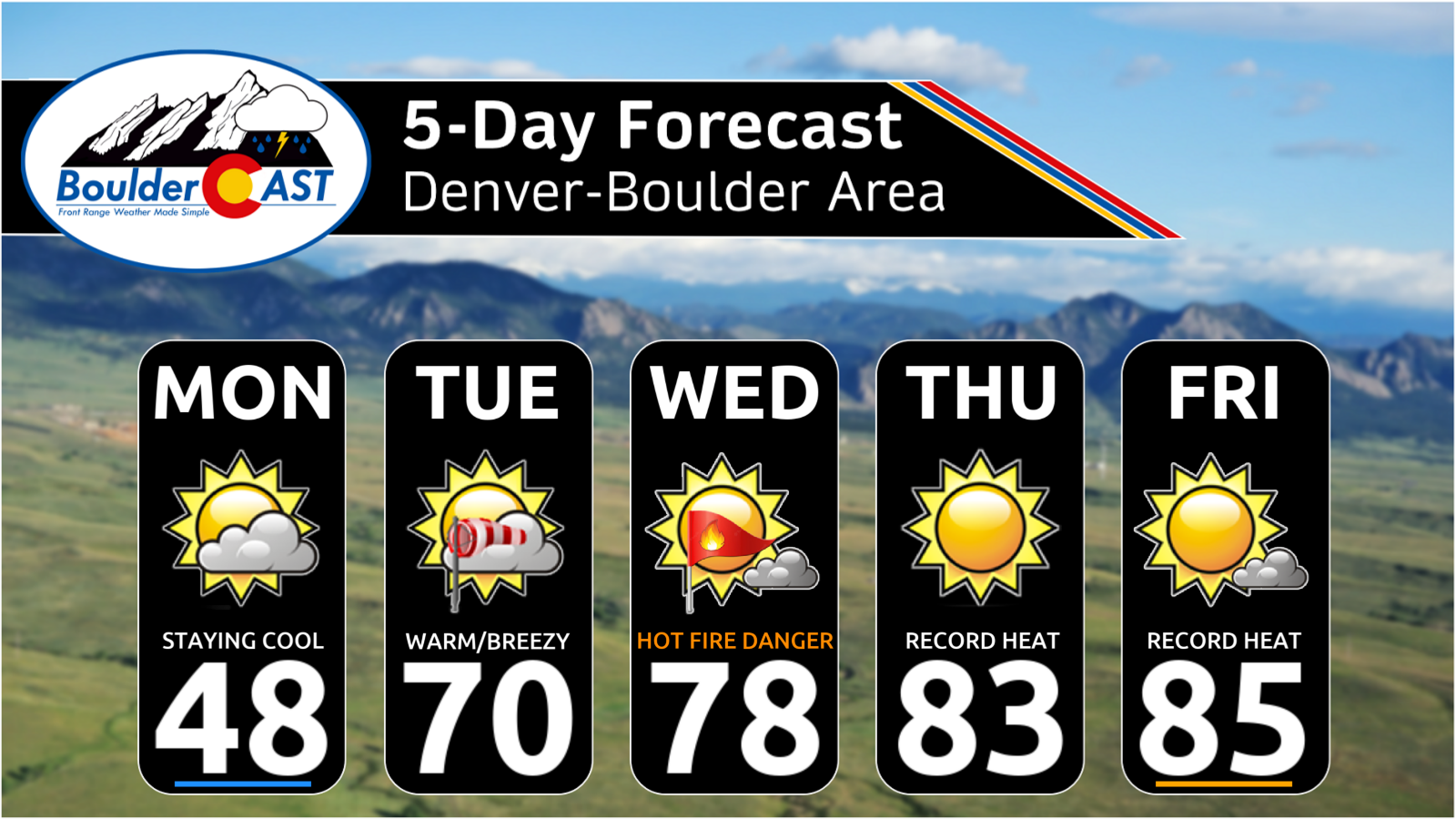
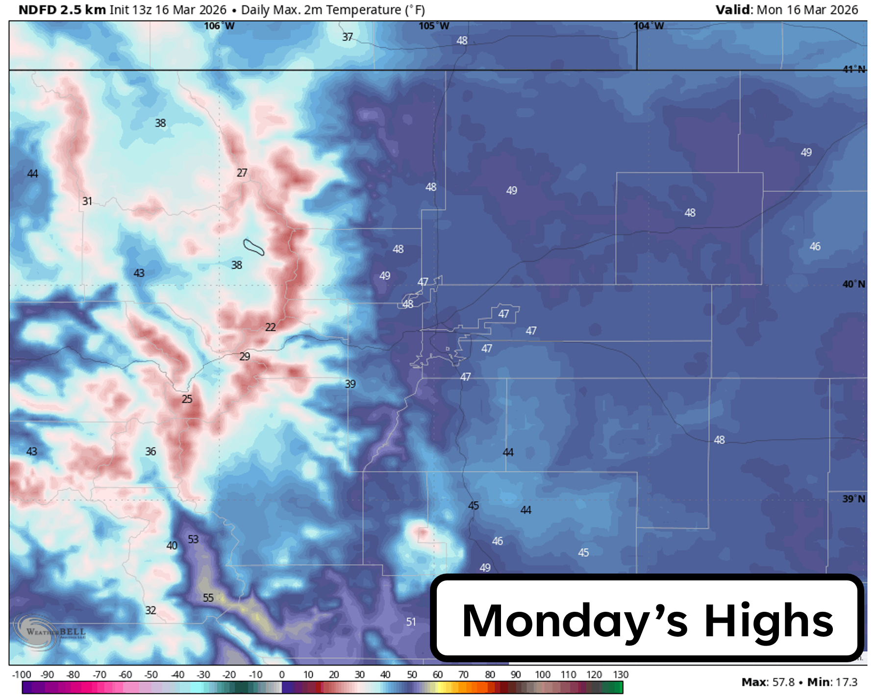
- 🌤️ Calm start for Colorado: Monday stays quiet and cool along the Front Range, with highs near 45–50° after a frigid teens start.
- 💨🔥 Downslope breezes & fire danger: Strengthening WNW flow Tuesday–Wednesday brings gusty downslope winds, highs in the 70s/near 80°, and elevated to near‑critical fire danger, especially north towards the Wyoming Border. Fire danger will remain elevated through the duration of the heatwave with at least light breeziness most afternoons.
- 🥵 Exceptional March heatwave incoming: A historic, highly anomalous ridge builds mid‑week, sending us into the low–mid 80s and setting the stage to shatter multiple daily and monthly March records.
- 📈 Ensembles show unprecedented warmth: Ensemble probabilities all highlight extreme, record‑level heat — well outside existing climatological databases.
- 🏆 Multiple records likely to fall: Boulder’s 83° March record (1910) is expected to be tied Thursday and broken Friday–Saturday; Denver’s 84° record (1971) is also at high risk.
- ⛓️💥 Heatwave breaks late weekend: A backdoor cold front may arrive Saturday night or Sunday, dropping highs into the 60s–70s, though the same warm airmass could return next week.
DISCLAIMER: This weekly outlook forecast is created Monday morning and covers the entire upcoming week. Accuracy will decrease as the week progresses as this post is NOT updated. To receive daily updated forecasts from our team, among many other perks, subscribe to BoulderCAST Premium.

Go Premium, get all the perks.
Daily Forecast Updates
Get our daily forecast discussion every morning delivered to your inbox.
All Our Model Data
Access to all our Colorado-centric high-resolution weather model graphics. Seriously — every one!
Ski & Hiking Forecasts
6-day forecasts for all the Colorado ski resorts, plus more than 120 hiking trails, including every 14er.
Smoke Forecasts
Wildfire smoke concentration predictions up to 72 hours into the future.
Exclusive Content
Weekend outlooks every Thursday, bonus storm updates, historical data and much more!
No Advertisements
Enjoy ad-free viewing on the entire site.
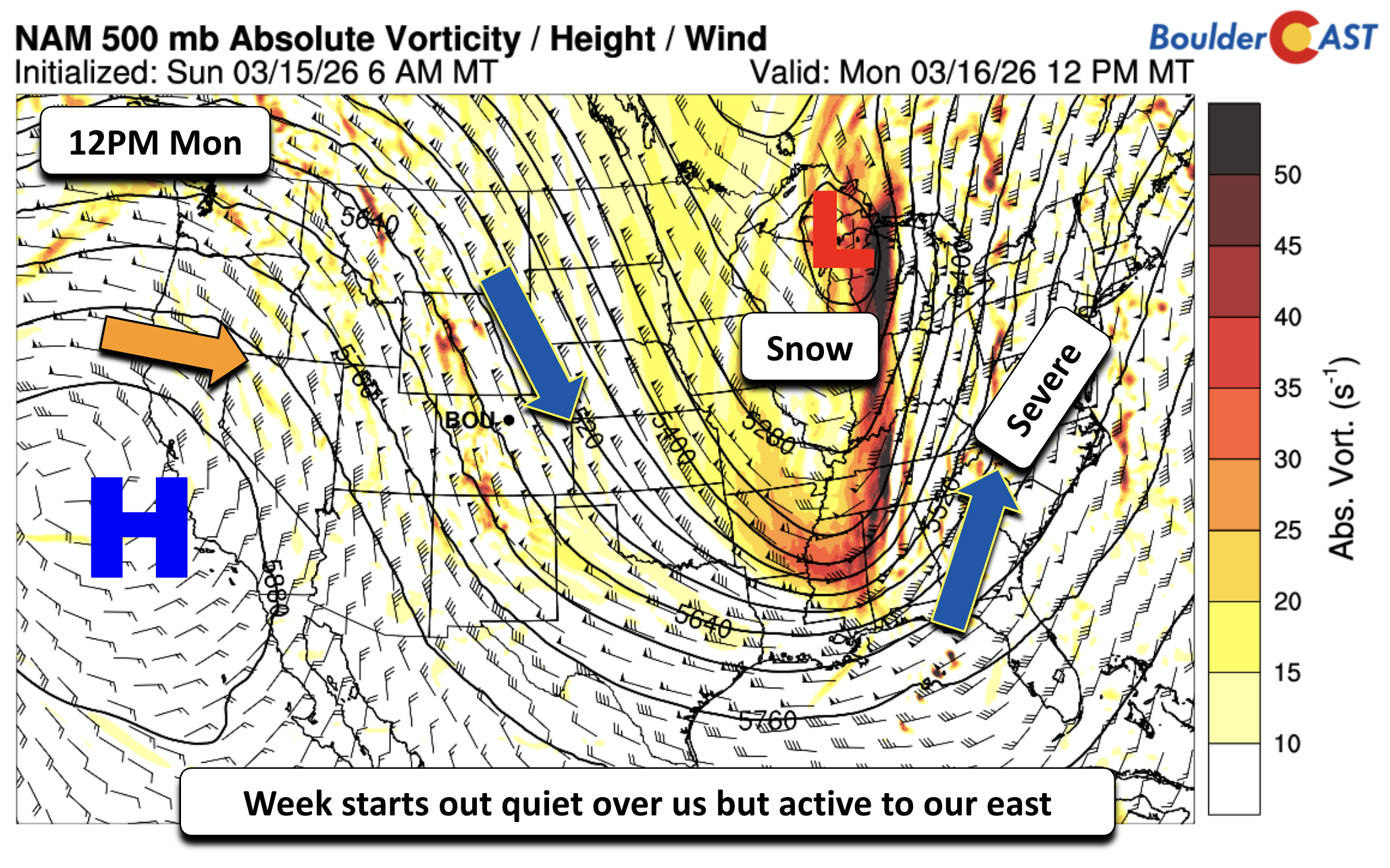
Cool and quiet Monday in Colorado, much more active for the rest of the nation
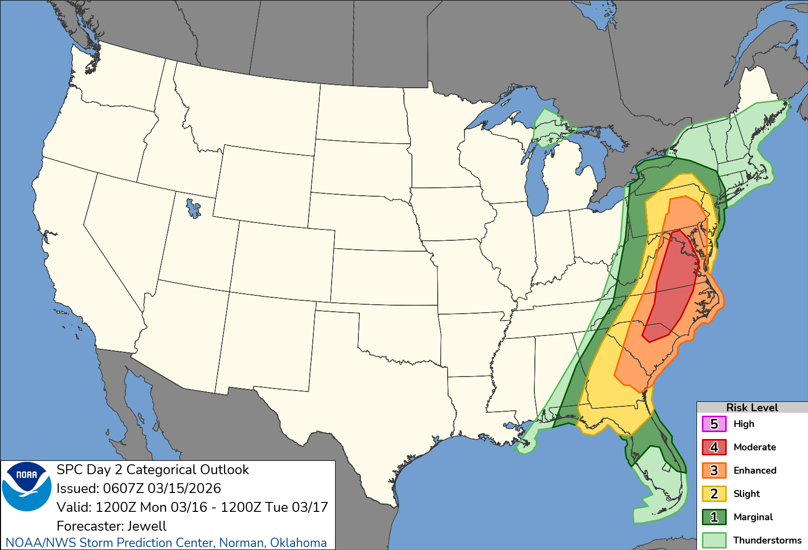
The week ahead starts relatively quiet over Colorado, but that is not the story to our east across the rest of the country. While we are in the wake of the cold air that is slowly filtering east in a WNW flow aloft, the real action is unfolding to our east, where a powerhouse storm system is tearing across the Great Lakes and Tennessee Valley and charging toward the Carolinas and Mid‑Atlantic today and tonight.
While we’re simply shaking off the leftover chill from yesterday’s cold front and snow, the rest of the country is dealing with a meteorological buffet:
- Heavy snow plastering Wisconsin and Michigan
- Late‑season cold gripping the Deep South
- Severe storms erupting across the Carolinas
It’s basically everything except calm east of the Mississippi.
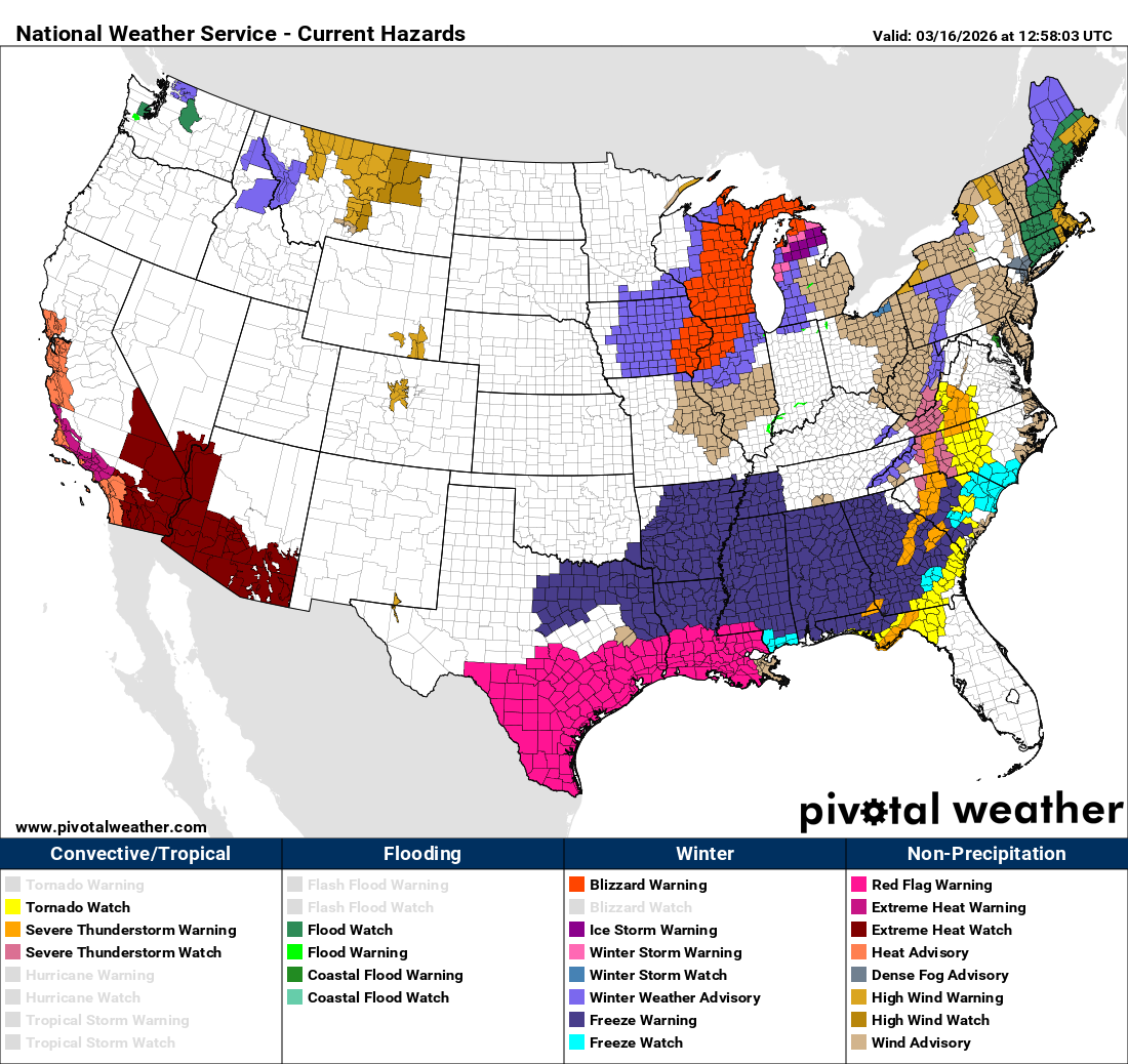
And the severe threat is no joke. The Storm Prediction Center has issued a Moderate Risk (Level 4 of 5) for the Southeast through the Carolinas and into the northern Mid‑Atlantic — a threat level that only shows up every 5–10 years in that part of the country. Strong tornadoes, destructive straight‑line winds, and pockets of large hail are all on the table. A very high‑end setup for mid‑March indeed!
Meanwhile… as mentioned, things are calm in the Front Range. We’ll enjoy a quiet Monday with highs in the 45–50° range after a frosty start in the teens.
A strengthening ridge, gusty downslope winds, and rising fire danger
Off the California coast, a ridge of high pressure is already gaining strength, and it’s going to be the dominant player in our weather for the rest of the week. Before it brings the truly unprecedented heat, we’ll spend Tuesday and Wednesday under a tightening west‑northwest flow as troughing lingers over the Upper Mississippi Valley.
That contrast — lower heights to our northeast, rising heights building into southern Nevada — is a classic setup for gusty downslope breezes along the Front Range. Expect breezy afternoons Tuesday and Wednesday, especially to our north closer to the Wyoming Border.
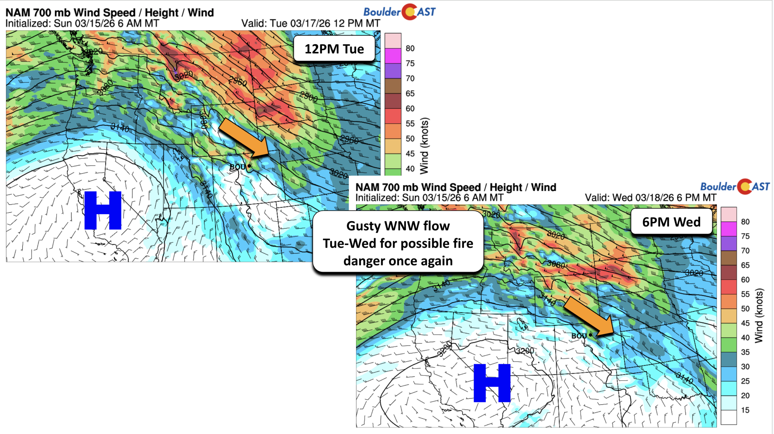
Temperatures will respond quickly to this downslope flow as well:
- Low 70s Tuesday
- Near 80° by Wednesday
Combine that with dry fuels and a landscape still parched from our long winter warm/dry spell, and we’re looking at elevated to near‑critical fire danger, especially Wednesday when temperatures spike. Some Red Flag Warnings may be issued along the Wyoming Border these days, but Boulder and Denver should stay just below criteria — helped slightly by our recent round of light snow. Still, it won’t take much to tip the scales, especially later in the week if the breeziness sticks around.
Exceptional heatwave begins Wednesday — and it’s one for the record books
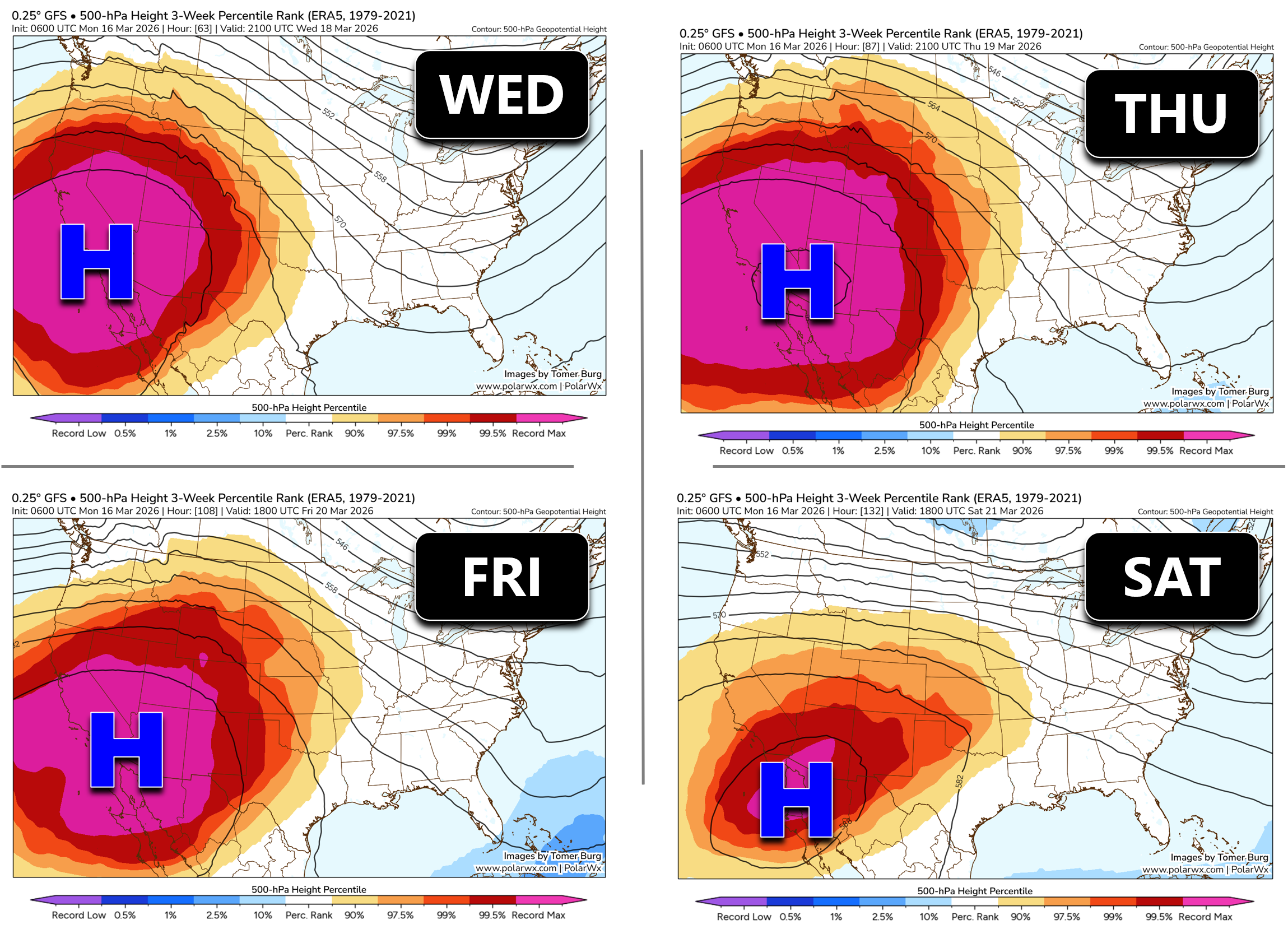
The mid‑ to late‑week pattern is nothing short of extraordinary. A massive, anomalous ridge will build inland from the Pacific and park itself near the Four Corners, sending temperatures across the Front Range skyrocketing.
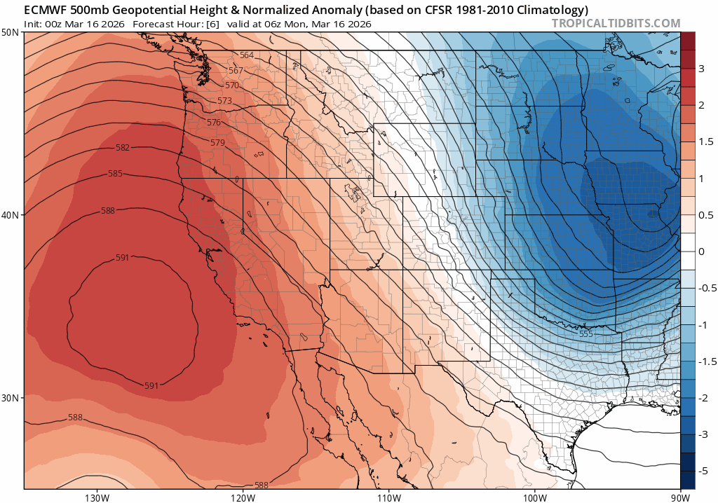
Euro model 500mb height anomaly forecast animation for Monday through Friday this week as the exceptional ridge holds over the Southwest.
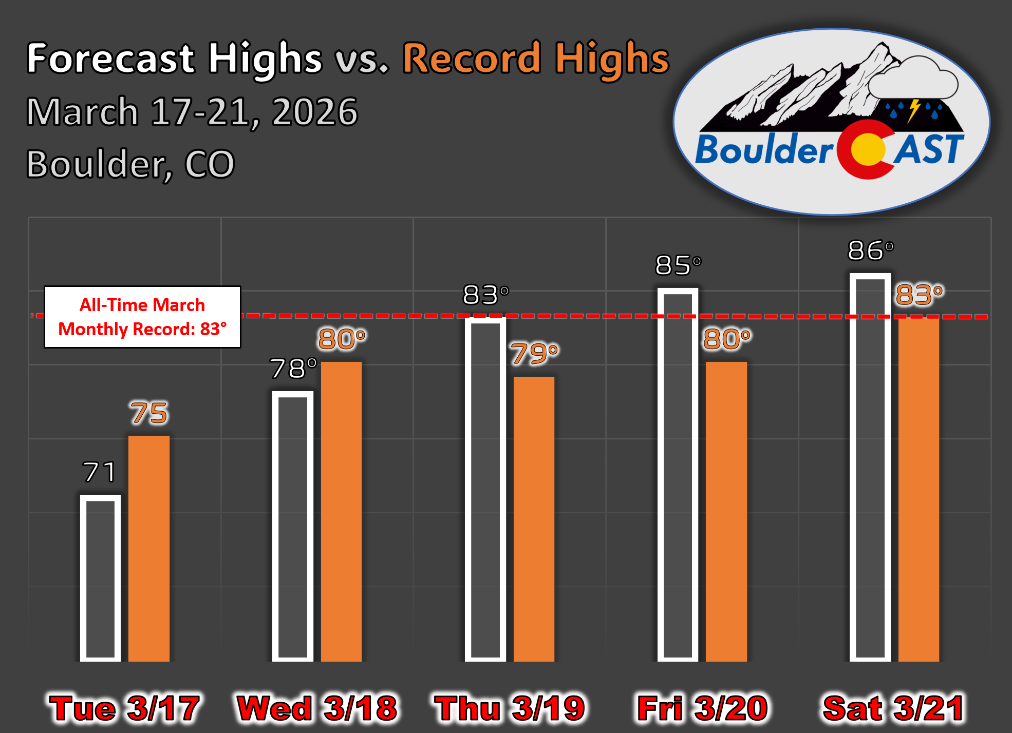
Below shows the daily temperature normals and records for March in Boulder. Circled in red are our record highs Wednesday through Saturday, ranging in the 79 to 83 degrees. As we’ll discuss shortly, a highly anomalous and extreme ridge will more than certainly blast away these record highs, where some of these records date back more than 100 years to 1910 and 1907.
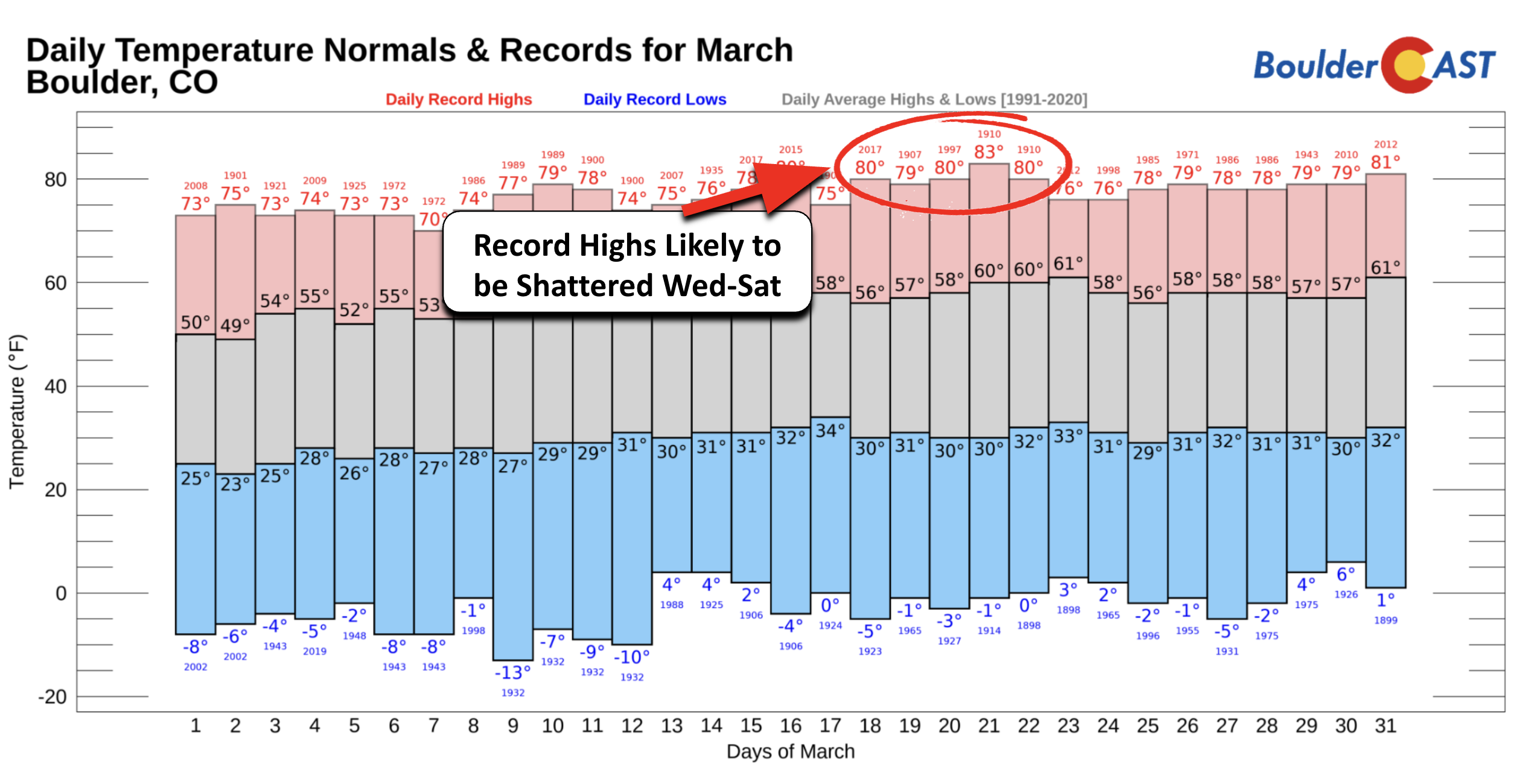
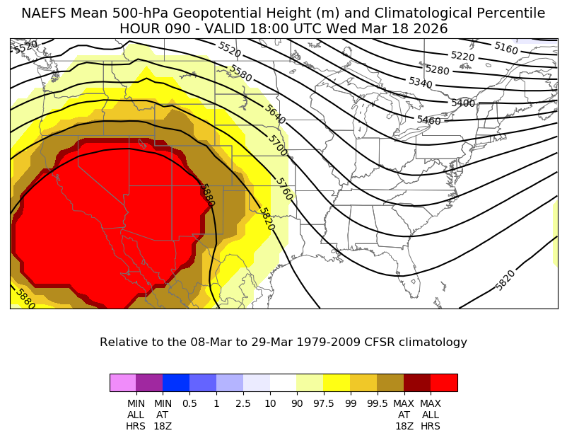
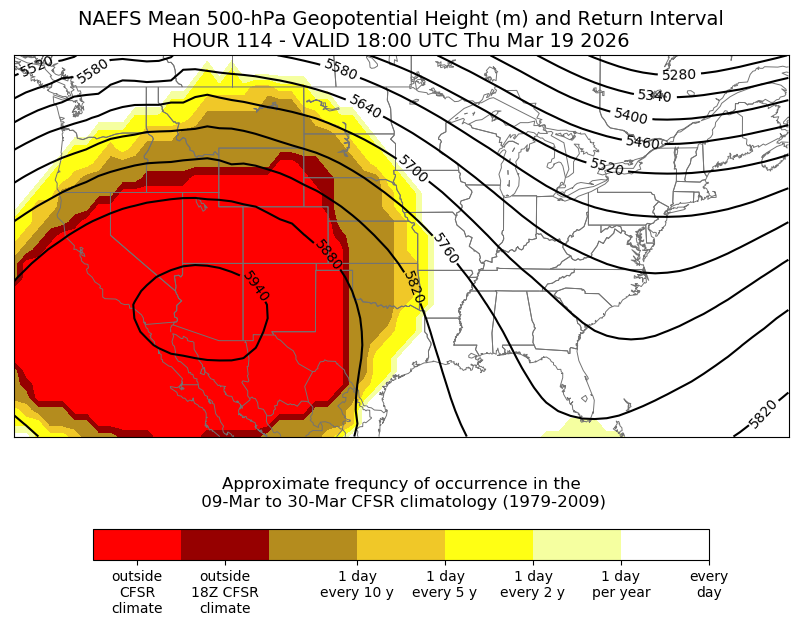
The ridge will be just southwest of the Four Corners by Wednesday. The NAEFS ensemble percentile graphics show a huge swath of “MAX” values for 500-mb heights — meaning the ridge is so strong it falls outside the 30‑year climatological record. By Wednesday, that extreme signal covers much of the Southwest and creeps into Colorado. Highs should surge towards 80 degrees, putting our 2017 record high in jeopardy.
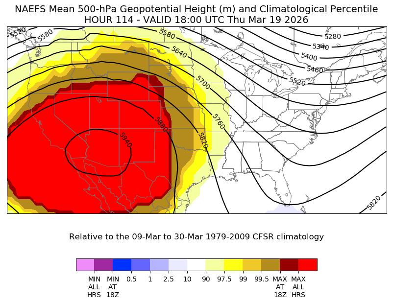
By Thursday, the ridge strengthens further, reaching 594 dm over Arizona — a height field typically reserved for mid‑summer, not mid‑March. “MAX” values expand across nearly all of Colorado, and Boulder should rocket into the low to mid‑80s, obliterating our 79° record.
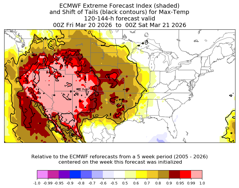
The European ensemble’s Extreme Forecast Index paints the same picture: nearly every member is screaming “record heat” for the Front Range Thursday and Friday.
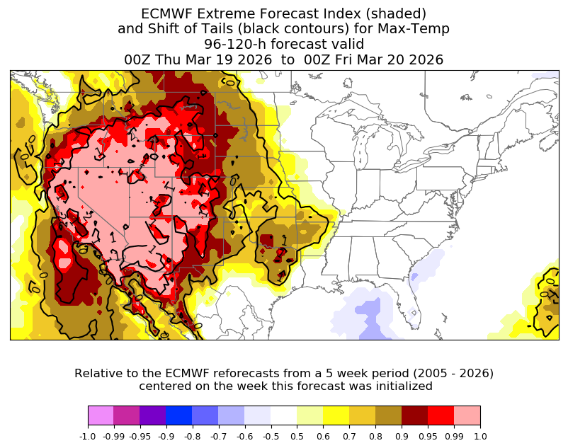
By Friday, EFI values approach 1.0 — essentially the model’s way of saying, “This is unprecedented.”
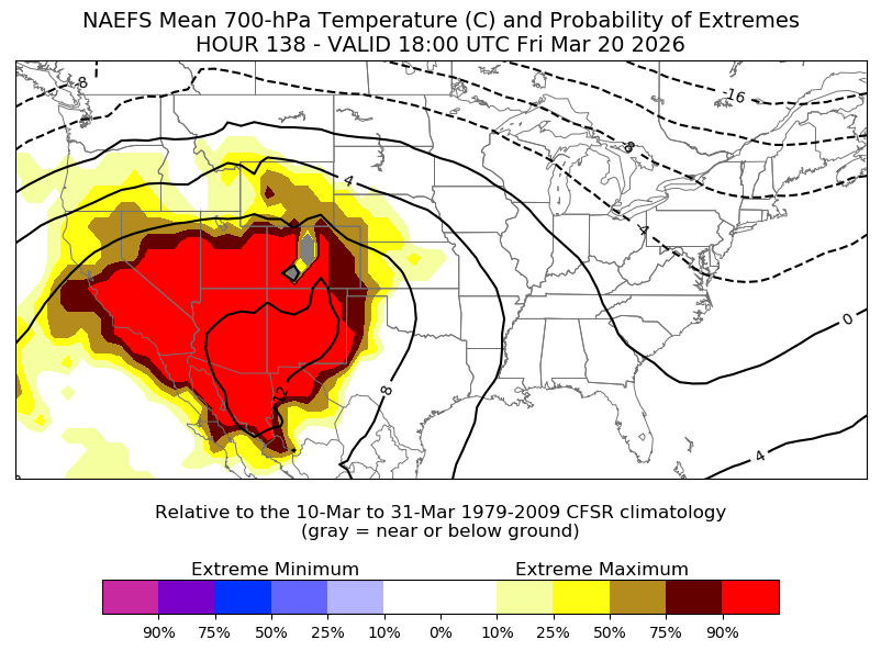
Even the 700‑mb temperature probabilities show >90% of ensemble members forecasting low‑level warmth above anything in the climatological record for this time of year. That’s the kind of signal you almost never see in March.
So, how extreme is this heat wave. One way to look at is via the return interval product, which asks the question, “how often do these forecasted conditions show up in the 30-year period of record?” The 500-mb (mid-level) heights are bright red over much of our state and the southwest U.S., meaning that the ensemble is forecasting an event that falls well outside the climatological record. So the heat this week is generally not seen a single time in at least a 30 to 50 year period. The probability of this occurring at any one time in March is roughly 2%, indicative of how rare and extreme this heat is for this time of year. To put it plainly: This heatwave is a once- or twice-in‑a-lifetime type of event for March.
By Saturday evening, most Front Range cities will likely have broken two to five consecutive daily records, with a strong chance of setting new all‑time March monthly records. Boulder’s March record is 83° (1910). Our forecast ties it Thursday, breaks it Friday, and then re-breaks it again Saturday. Denver’s March record of 84° (1971) is also on the chopping block.
When does the heatwave end?
Good news: Relief from the heat — or at least a pause — looks possible by late weekend.
By Saturday night into Sunday, the ridge will begin to flatten, opening the door for a backdoor cold front to slip into eastern Colorado.
Most ensemble members support this idea, though details remain fuzzy at this range. Sunday’s highs could fall back into the 60s or 70s, with some model scenarios even hinting at 50s. The ridge won’t rebuild in the same extreme fashion, but the hot airmass it previously cooked up will still be lurking to our southwest, ready to push back in next week if the pattern allows.
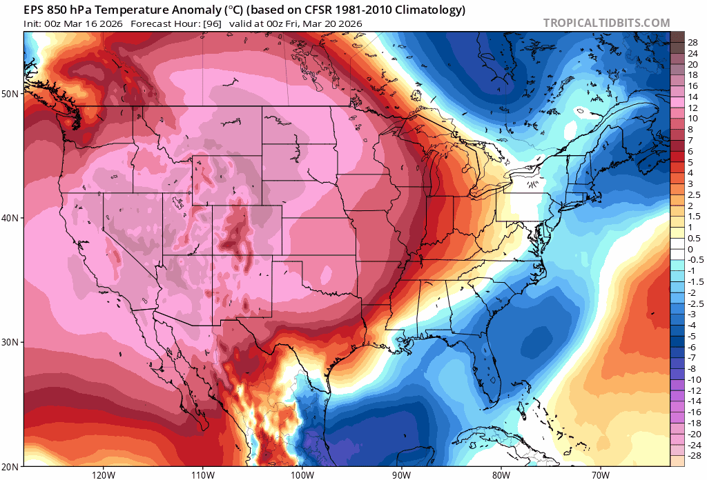
Mean 850mb near-surface temperature anomaly forecast animation from the Euro ensemble for Friday into Sunday showing the cool front coming into NE Colorado
For now, the message is simple: Plan for extreme warmth Wednesday through Saturday — multiple days near or above 80°, with some well into the 80s. There’s even a tiny, fading chance of a 90° reading. If that happened, it would obliterate the earliest 90° day on record for both Boulder (currently May 15) and Denver (April 30) by six to eight weeks! At this point, 90° seems out of reach, but the models have never seen this extreme of a pattern before so it is something to watch.
Forecast Specifics:
Monday: Cool, but not as cold with highs in the 40s to near 50 for the Plains and 40 in the Foothills. Partly cloudy skies.
Tuesday: Partly cloudy, warm and breezy. Highs warmer in the lower 70s on the Plains with upper 50s in the Foothills. Winds during the day will gust over 25 MPH, increasing fire danger especially north of Boulder.
Wednesday: Very warm and gusty with near-record highs on the Plains in the lower 80s, then upper 60s in the Foothills. Winds may gust over 30 MPH during the afternoon, favoring a heightened fire danger threat, mainly north of Bouder.
Thursday and Friday: Record-shattering highs in the mid 80s with mostly sunny skies. Depending on how breezy it is, fire danger may stay elevated to near-critical.
Weekend: Saturday stays hot for this time of year with another record-setting day likely in the middle to upper 80s. A cold front may approach late this weekend, likely dropping us below record territory into the 60s or 70s by Sunday, but still above normal.
DISCLAIMER: This weekly outlook forecast is created Monday morning and covers the entire upcoming week. Accuracy will decrease as the week progresses as this post is NOT updated. To receive daily updated forecasts from our team, among many other perks, subscribe to BoulderCAST Premium.
Go Premium, get all the perks.
Daily Forecast Updates
Get our daily forecast discussion every morning delivered to your inbox.
All Our Model Data
Access to all our Colorado-centric high-resolution weather model graphics. Seriously — every one!
Ski & Hiking Forecasts
6-day forecasts for all the Colorado ski resorts, plus more than 120 hiking trails, including every 14er.
Smoke Forecasts
Wildfire smoke concentration predictions up to 72 hours into the future.
Exclusive Content
Weekend outlooks every Thursday, bonus storm updates, historical data and much more!
No Advertisements
Enjoy ad-free viewing on the entire site.
Enjoy our content? Give it a share!


A fitting end to winter… don’t you think?
A fitting end to this winter, certainly.