
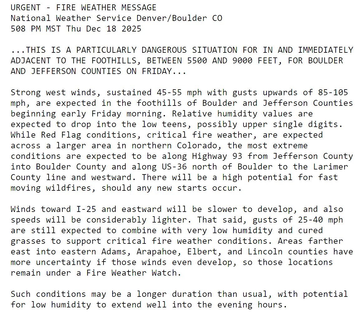
Updated (7AM Friday 12/19): Updated based on latest guidance adjusting timings and intensity of wind/fire impacts, and also made a stronger case for the extreme winds (and fire danger) to potentially stay mostly in the Foothills or very close to there. Lowered wind/fire risk in Boulder proper. This is still a very dangerous situation.
—
Boulder, the far western suburbs of Denver, and the Foothills are bracing for yet another powerful mountain wave windstorm Friday, with gusts likely topping 75–100 MPH and, this time, extreme fire danger will be layered on top. Forecast models show the strongest winds during the morning into the afternoon, coinciding with critically dry air and record‑challenging warmth. Power shutoffs, downed trees, and blowing dust are all on the table, but the bigger story is the fire risk—conditions are primed for rapid spread if any ignition occurs. Fortunately it now appears that most of the intense winds will stay largely in the Foothills, but there is some uncertainty how far downhill and east they will reach. Read on for the full breakdown of timing, impacts, and what you need to know to stay safe. We also briefly review the damaging wind event that just occurred on Wednesday.
What You Need to Know
- 🌬️ Another intense mountain wave windstorm on Friday: a classic atmospheric setup will be primed for extreme downslope winds for the second time in three days in our area.
- 💨 Peak gusts 70–105 MPH in the Foothills between 6 AM–5 PM, with a sharp gradient heading away from the Foothills. May not be too bad in Boulder, but stay alert!
- 🪵 Wind damage potential: downed trees, snapped limbs, blowing dust/haze reducing visibility.
- 🔥 Extreme fire danger this time: very dry air will overlap the strongest winds for hours, any fire ignition would spread rapidly eastward, especially in the lower Foothills.
- 🚨 Red Flag Warning 10 AM–Midnight (Foothills 5 AM–Midnight); residents urged to secure property, avoid sparks/flames, and stay evacuation‑ready.
- ⚡ Power impacts: Xcel will shutdown power for the high-risk areas early Friday (~5AM); those outages, and unplanned ones, will last into Friday night or beyond.
- 👜 Evacuation readiness: keep go‑bags stocked, know evac routes, and stay weather aware all day Friday and Friday evening

Go Premium, get all the perks.
Daily Forecast Updates
Get our daily forecast discussion every morning delivered to your inbox.
All Our Model Data
Access to all our Colorado-centric high-resolution weather model graphics. Seriously — every one!
Ski & Hiking Forecasts
6-day forecasts for all the Colorado ski resorts, plus more than 120 hiking trails, including every 14er.
Smoke Forecasts
Wildfire smoke concentration predictions up to 72 hours into the future.
Exclusive Content
Weekend outlooks every Thursday, bonus storm updates, historical data and much more!
No Advertisements
Enjoy ad-free viewing on the entire site.
NOTE: If you’re only here for the forecast for the Friday windstorm and extreme fire danger, scroll down quite a ways to the FORECAST section.
RECAP: The strongest windstorm for Boulder in 20+ years
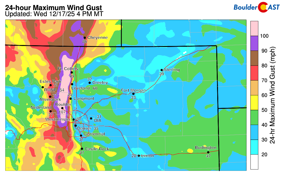
Yesterday’s windstorm was one for the record books. Boulder and the western Metro area sat under the brunt of a powerful mountain wave event, with sustained gusts in the 60–90 MPH range for nearly five hours from Noon to 5PM, which roughly aligned with our expectations and forecast.
Several locations reported hurricane‑force winds over 100 MPH, including a peak of ~108 MPH at NCAR Mesa in south Boulder.
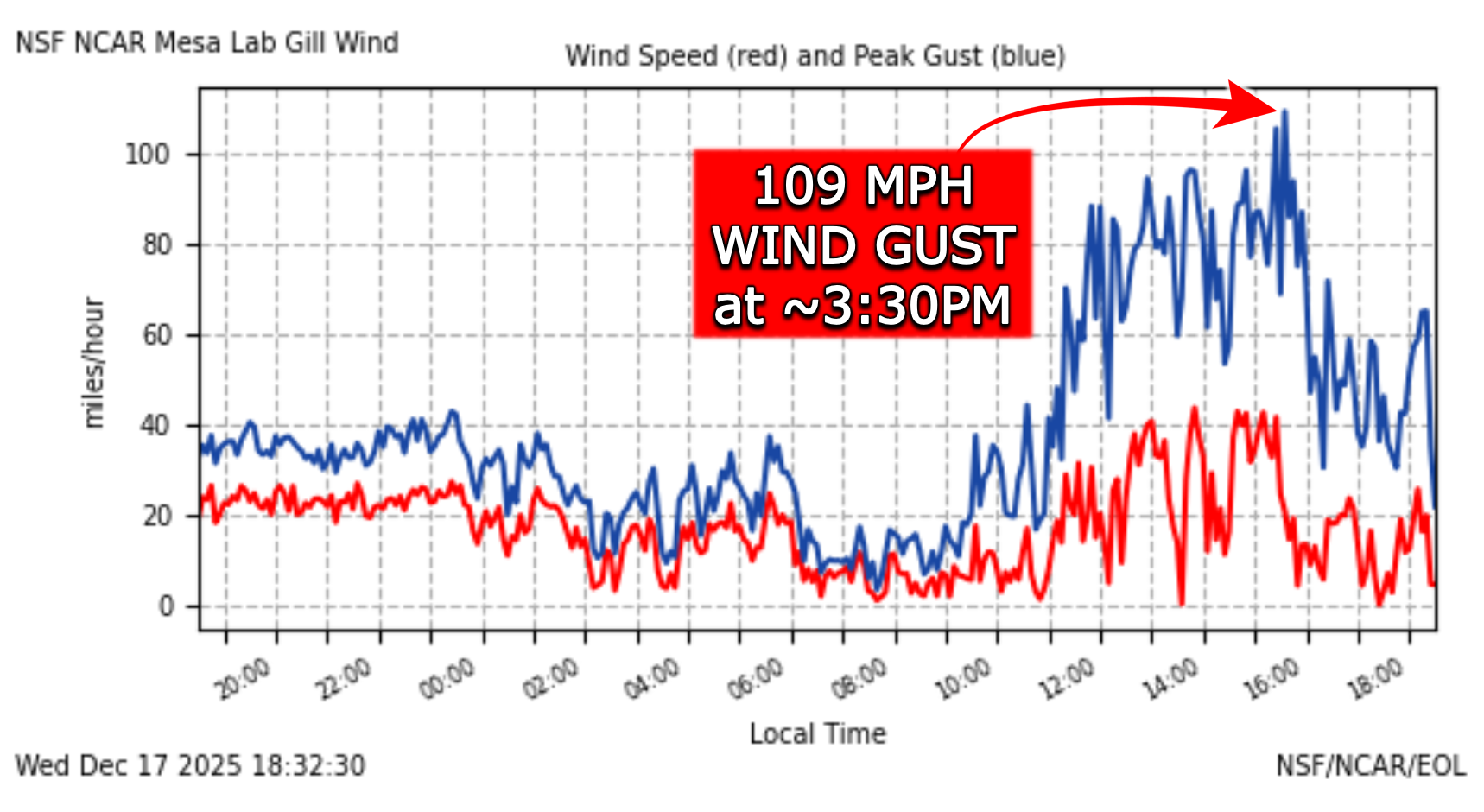
Boulder Airport had it’s strongest wind gust on record Wednesday afternoon—a gust of 87 MPH eclipsing the previous record by 13 MPH. Note that this particular automated weather station’s data record only goes back to 2010, so this was the strongest gust there in at least the last 15 years, but likely much longer.

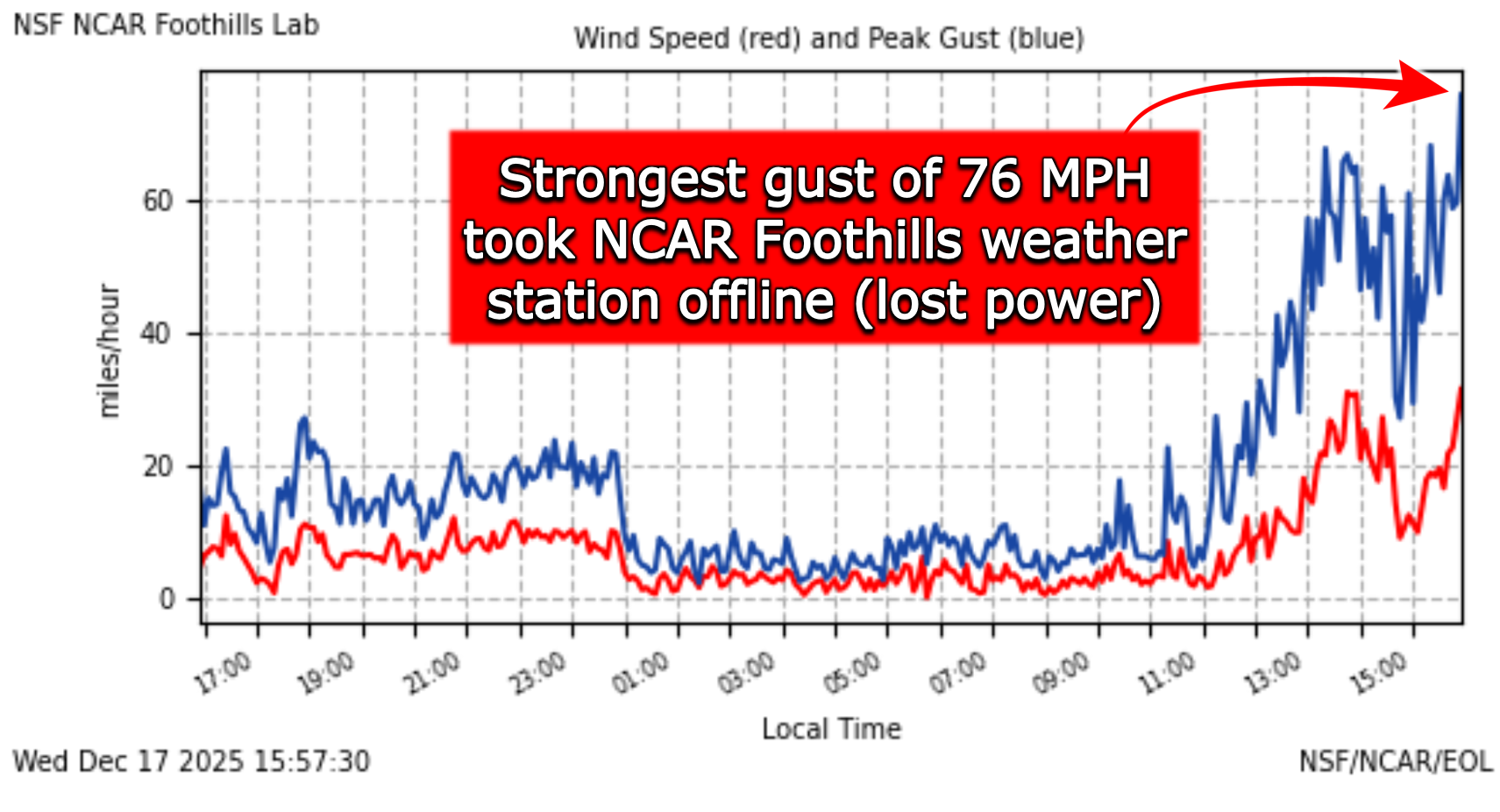
The NCAR Foothills Lab in east Boulder recorded its strongest gust of the day, 76 MPH, mere moments before the station lost power (and it still remains offline).
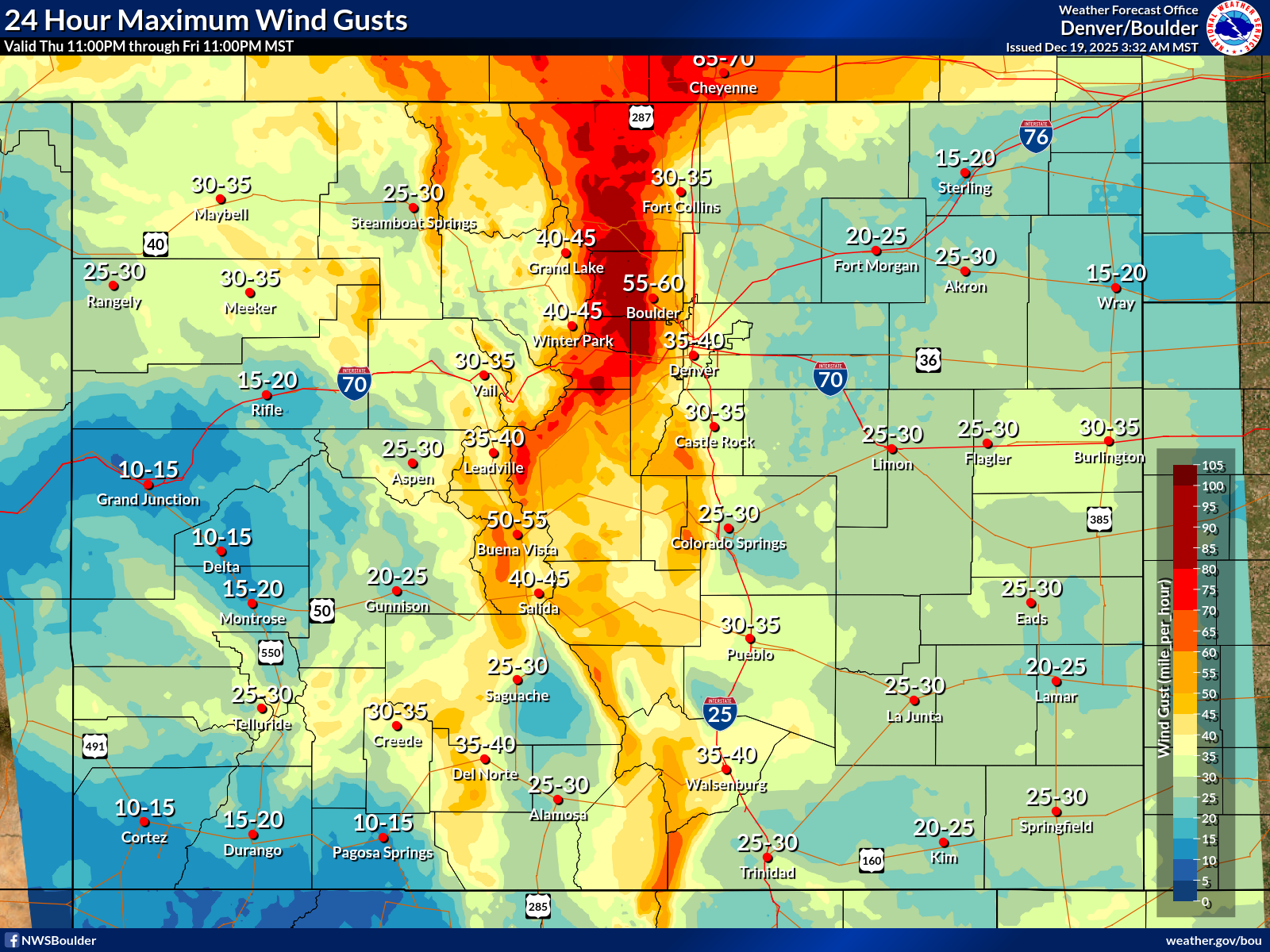
Looking more broadly across the Front Range, peak wind gusts were above 45 MPH pretty much everywhere, with the strongest gusts up to 110 MPH recorded in and near the lower Foothills where the mountain wave crashed down hardest and winds accelerated downhill. Equally strong 100+ MPH wind gusts were recorded further west on the peaks of a few mountains (including Berthoud Pass), but that’s not all that unusual.
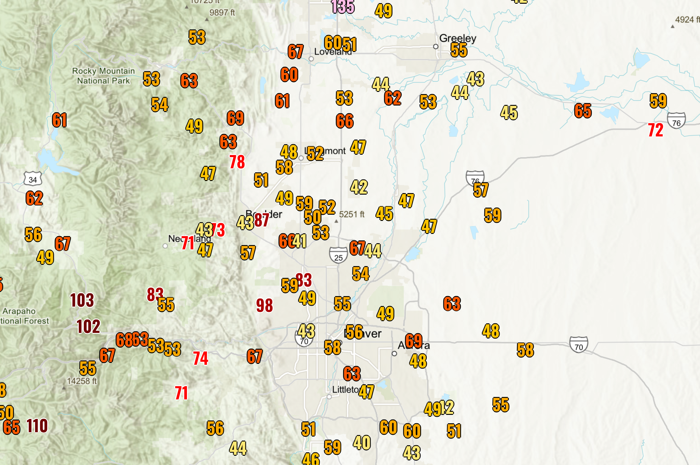
Here’s a closer look at Boulder and the northern Metro area’s peak wind gusts:

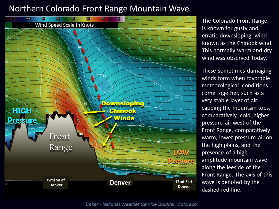
The high winds on Wednesday actually came in two waves from two separate atmospheric phenomena. The strongest winds of the day were observed right in and near the base of the Foothills via a mountain wave setup, where fast wind flowing across the Continental Divide, wind that would normally be 5,000-10,000 feet above the ground, gets forced down the surface and can accelerate downhill into the far western Metro area and Foothills. These are also known as Chinook winds in most cases.
This is exactly what happened during the bulk of the wind event on Wednesday, mainly before sunset. Peak wind gusts before 4PM show a strong mountain wave signature, with intense ~100MPH gusts parallel to the terrain along the interface between the Foothills and lower elevations. The slope of the terrain is important for these winds to propagate, so they often don’t extend too far away from the base of the Foothills. On Wednesday, they reached probably 5-7 miles eastward at most.
The second burst of wind that came Wednesday evening via what is known as a bora wind event, where cold, dense air spills down off the terrain and spreads out across the entirety of eastern Colorado. Additional downward momentum is injected into this setup from large-scale features, like troughs and jet-streaks. Notice how the peak wind gust map changed after the bora portion of our windstorm Wednesday evening. Everywhere east of Interstate 25 saw their strongest winds of the day from this secondary part of the storm, including some gusts of 80 MPH on the eastern Plains.
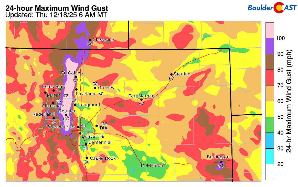
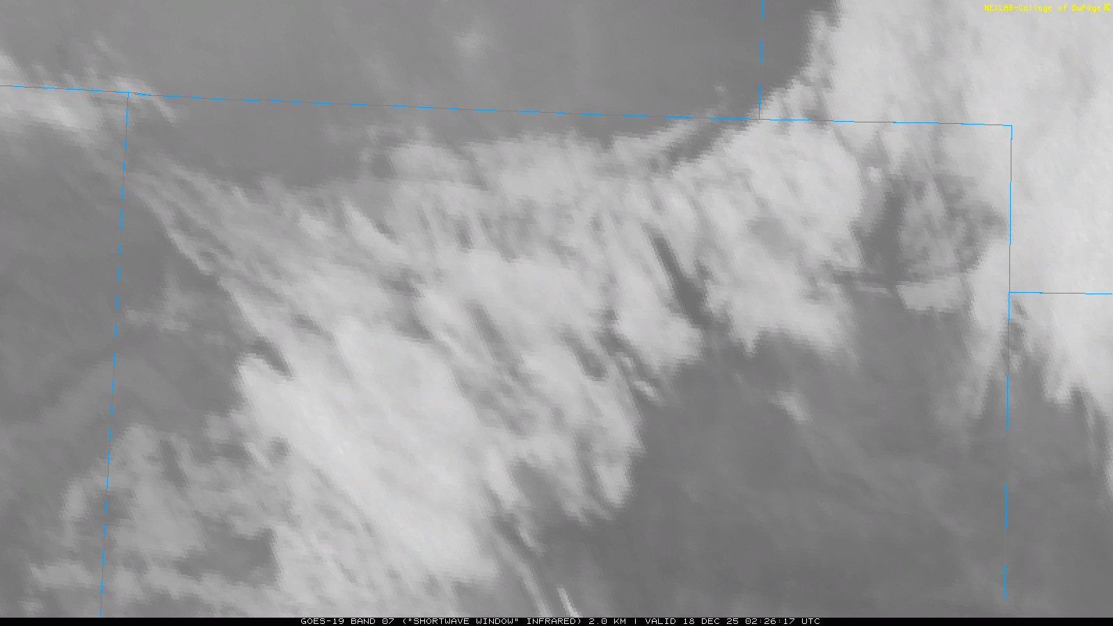
The extreme winds accompanying and just behind the cold frontal passage Wednesday evening sparked several large grassfires in far eastern Colorado, likely from falling trees taking down powerlines. The fires show up as black spots on the infrared satellite animation below from the time of the front and bora event was peaking (9PM to Midnight).
As of Thursday morning, there is only one wildfire still uncontained near Yuma in eastern Colorado, but it’s a doozy at 12,000 acres burned. Firefighters won’t just be battling the fire today, but also 70 MPH winds and blowing dust out there. Hopefully it can be contained but the winds will be fierce, making that difficult at least for Thursday.
Fortunately the rest of Colorado, especially the more populated Front Range, avoided any fire ignitions, undoubtedly at least in part due to the Xcel planned shutdowns. Xcel still lists nearly 90,000 customers without power statewide, with about 30,000 of those in Boulder County alone. If you haven’t seen just how many large, mature trees are toppled in Boulder, you’ll have to take our word for it when we say this would have been a lot worse if power lines have been energized. Damage across the western suburbs is extensive—downed trees, snapped utility lines and poles, fences flattened and heaps of unplanned power outages. Ryan Heiland, assistant director of Outdoor Services at CU Boulder, told us he’s never seen the raw power of the wind cause this much destruction on campus in his 23 years there. Some trees didn’t just fall over, they snapped in half like toothpicks.
Similar “toothpick snaps” were observed on power poles between Boulder and Golden, where nearby wind sensors also detected gusts around 100 MPH.
The cleanup from this windstorm will take many days, with Xcel’s power restoration efforts proceeding slowly and timelines generally unknown right now. Some of us could see power restored during the day Thursday, but many won’t and the bad news is another windstorm is brewing for Friday—one that will certainly cause more planned and unplanned outages in the very same communities.
FORECAST: Same strong winds, MUCH higher fire danger
Unfortunately, the atmosphere isn’t giving us much of a break. Another once-in-a-decade mountain wave windstorm is lining up for Friday, and this one looks like a more “classic” setup. A strong jet streak will nose into northern Colorado late Thursday night, with westerly cross‑barrier flow ramping up through Friday morning. A stout inversion just above the mountain tops will help trap and amplify winds down the leeward slope. Furthermore, by Friday afternoon, northern Colorado will land in the subsident right‑exit region of the jet leading to additional downward momentum transfer. All of the necessary ingredients are coming together for another round of extreme downslope winds in and near the Foothills.
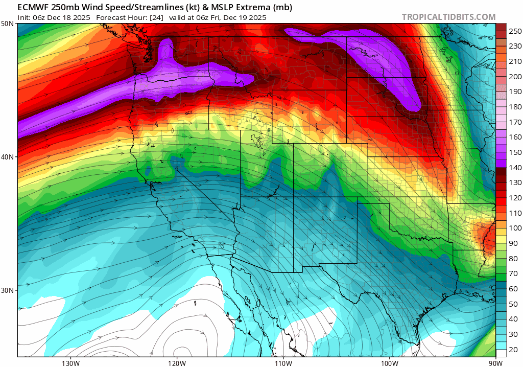
Jet stream forecast animation from the Euro model from late Thursday night into Saturday afternoon.
The models—yes, including our trusty HRRR—are already painting the picture. The mountain wave will begin to take shape after midnight Thursday night, first in the Foothills in the wee morning hours, with damaging gusts potentially spilling into Boulder by mid‑to‑late morning Friday. The bullseye window looks to be 10 AM through 4 PM in town, when peak gusts could once again roar into the 80–100 MPH range. That’s essentially the same intensity as Wednesday’s destructive storm, maybe even a notch stronger. Far western Boulder (west of Broadway) stands the best chance to see damaging winds again. The only real uncertainty is how far east the most ferocious winds will reach. Recent model runs have backed off slightly on the eastward extent, but the Foothills and areas within a mile or so remain at high risk. The way the models have trended, though, this could end up being not too bad for a majority of our readers, with the most extreme winds barely staying up in the Foothills to the west. The strongest winds for areas away from the terrain are expected to happen after dark when the wave begins to break down. As it weakens, it will propagate eastward bringing gusts up to 55 MPH as far east as Denver International Airport during the evening.
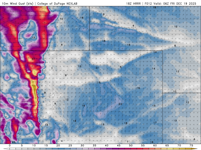
HRRR model wind gust forecast for Thursday night into Friday night. Extreme downslope wind signatures are indicated.
The HRRR is even showing signs of additional wave breaks lining up parallel to the terrain further east. This is a textbook signature of an upper echelon Chinook wind event about to unfold. This is a meteorology professors’ dream material, but for us on the ground, it’s a nightmare scenario.

Despite the encore of damaging winds, the bigger concern this time around is the fire danger. Wednesday’s storm did not overlap high winds with critically dry air for very long (or at all), which helped limit fire risk. Friday will be different. Much different. Relative humidities below 15% are expected to coincide with the strongest winds for several hours, creating conditions primed for rapid eastward fire growth. The dry air will extend well into the Foothills, overlapping perfectly with the extreme winds up there. Even after the mountain wave begins to break down Friday evening, gusty conditions will linger with bone‑dry air still in place. Fire danger won’t be quite as extreme after dark, but it will remain near‑critical well into the evening hours. 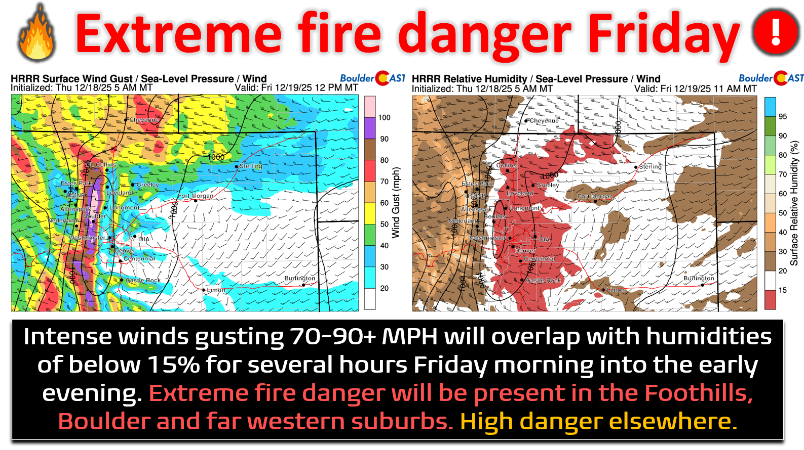
Relief won’t arrive until around midnight Friday night, when a cold front slides in from the northwest:
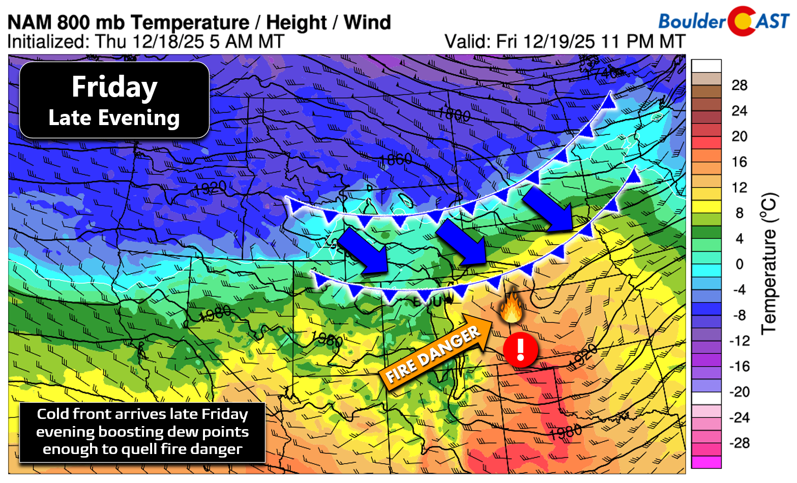
This front should quell most of the fire danger and bring safer conditions during the overnight hours, despite lingering gusty winds.
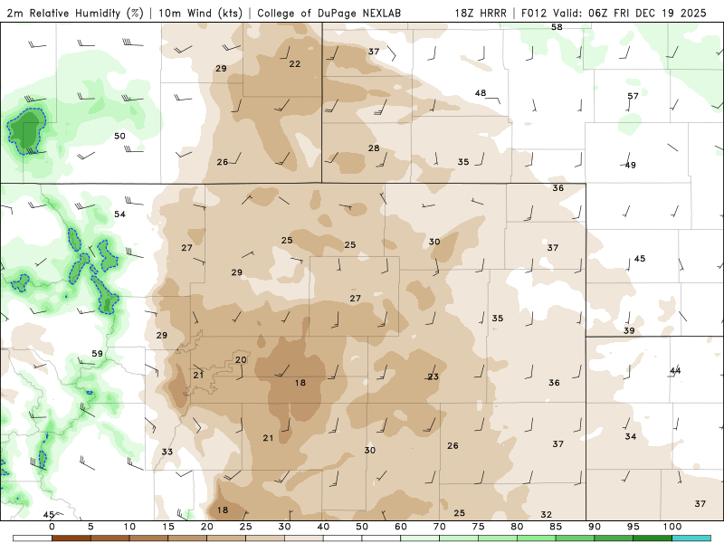
Relative humidity forecast animation for Thursday into Thursday night. Critically dry air will exist all day Thursday over our entire area.
A Red Flag Warning is in effect regionwide from 10AM to Midnight (5AM to Midnight in the Foothills), and this one has been given the very rare “Particularly Dangerous” distinction by the National Weather Service.


We’re not trying to scare or panic the public, but Friday’s setup is at least as primed for explosive fire behavior as the day of the Marshall Fire. The saving grace is that fuels are less abundant this year, and Xcel is proactively planning to de‑energize parts of the grid to reduce ignition risk. Still, fire danger will be about as high as it gets for the Front Range. We cannot afford any ignitions Friday—whether in the forests of the Foothills or the prairie grass of the flatlands.

Finally, compressional warming will push temperatures into the upper 60s to low 70s across the lower elevations Friday afternoon. Boulder’s December 19th record high of 69° (set back in 1979) is in jeopardy. The only thing keeping temps somewhat in check will be the extensive wave cloud cover.
Impact & Risk Timelines
Thursday’s cool, sunny and calmer weather a chance to repair the grid, but the reprieve is short‑lived. By midnight, the mountain wave starts to flex along the Divide. Through the early morning hours, extreme winds cascade downslope into the Foothills, reaching Boulder by mid‑to‑late morning. Impacts will be severe:
- Scattered power outages, both planned and unplanned
- Downed trees and snapped limbs—some trees broken clean like toothpicks
- Flattened fences across suburban neighborhoods (only in areas right up against the Foothill base)
- Blowing dust and haze reducing visibility
But again, the primary risk isn’t just the wind damage—it’s the fire danger layered on top. Extreme fire conditions will commence in the Foothills early Friday morning before sunrise, spreading into Boulder by late morning, and near‑critical fire danger will extend across the Denver Metro. Even lighter winds farther east won’t prevent rapid fire spread thanks to the same dry air mass.
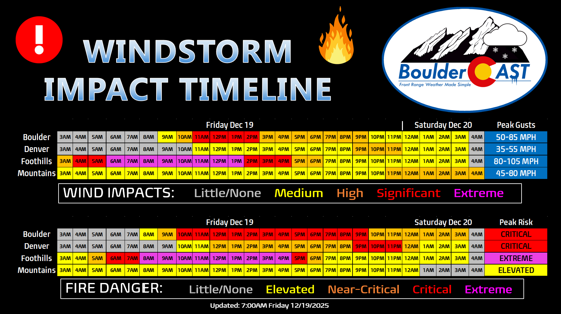
Expected Peak Wind Gusts
- Foothills and wind‑prone spots (Boulder, Rocky Flats, north Golden, far west Arvada): Peak gusts of 75–105 MPH are likely.
- Metro corridor near I‑25: Gusts of 25–45 MPH expected
- Farther east (DIA, Aurora, Parker): Mostly 20–40 MPH or less.
Probability of a least one wind gust exceeding various thresholds within 5 miles of BOULDER (mostly in the Foothills/west side of town):
- 60 MPH: 100%
- 70 MPH: 95%
- 80 MPH: 90%
- 90 MPH: 55%
- 100 MPH: 30%
- 110 MPH: 10%
Probability of a least one wind gust exceeding various thresholds within 5 miles of DENVER:
- 60 MPH: 40%
- 70 MPH: 10%
- 80 MPH: 0%
- 90 MPH: 0%
- 100 MPH: 0%
- 110 MPH: 0%
Planned Power Shutdowns
Xcel hasn’t made a final decision on the planned power shutdowns, but they have issued watches for areas that will likely go dark beginning early Friday morning around 5AM. There could be some staggered timing (earlier in Foothills, later for Boulder/Metro area), but we’re not sure yet. Areas highlighted in orange below are included in the potential shutoff plans for Friday. Plan for power to be shut off at least until 10PM, but it will likely be longer in some areas, perhaps pushing well into Saturday or later. Xcel has to have time to access and repair your grid sector before power will be restored. Depending on the extent of any damage, this could take a while. Less populated Foothills communities will be a lower priority.
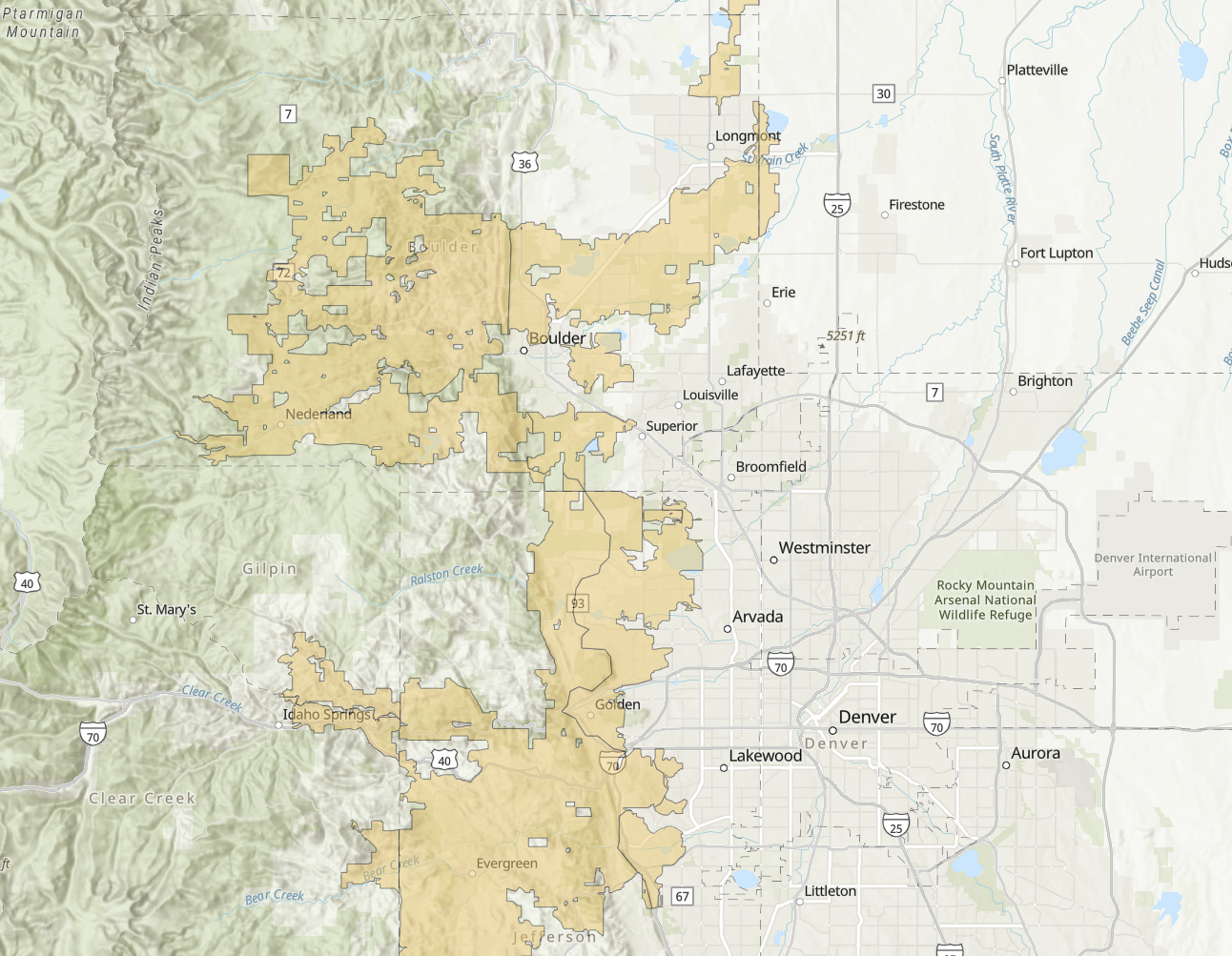
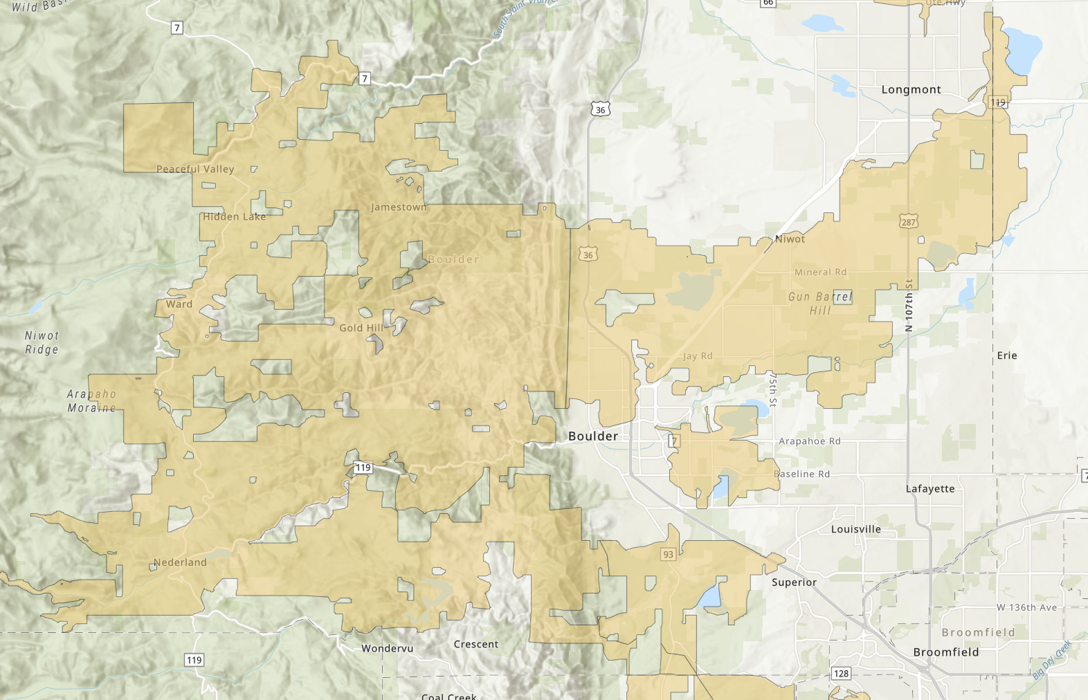
For updates on planned outages, check the Xcel website for:
Be Safe and Prepare!
Friday’s windstorm isn’t just another round of potentially damaging gusts—it’s a dangerous overlap of extreme downslope winds and critically dry air. The Foothills are staring down peak gusts in the 75–100 MPH range from the early morning through late afternoon, with relative humidities below 15% during the worst of it. That combination is primed for explosive fire growth. This is the kind of setup where even a single spark can turn into a fast‑moving blaze racing eastward across grasslands or downwind forests. Yes, just like the Marshall Fire.
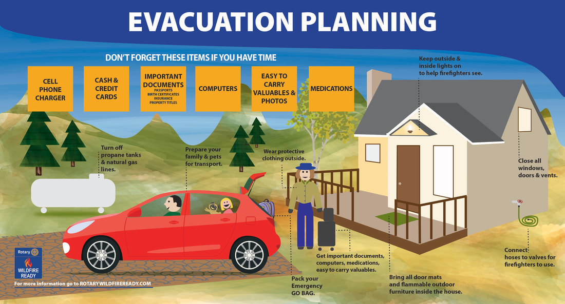
You should prepare for both wind impacts and fire danger:
- Secure your property: Tie down or bring inside anything that can blow away—patio furniture, trash bins, holiday decorations. These items can become projectiles in 80+ MPH winds. We’ve seen this already with window shattering on homes and cars on Wednesday.
- Plan for outages: Xcel WILL proactively shut off power in high‑risk areas starting early Friday morning. Have flashlights, batteries, and backup charging options ready. Assume outages could last well into the weekend or even longer.
- Fire safety is non‑negotiable: Absolutely no outdoor burning, grilling, or use of fire pits. Avoid smoking outdoors; if you must, do so responsibly and never discard butts outside.
- Vehicle precautions: Don’t park on tall grass or brush—hot exhaust systems can ignite dry fuels.
- Equipment awareness: Postpone any outdoor work involving tools that can spark (chainsaws, welders, grinders). Even lawnmowers can be risky in these conditions. A fire started in Boulder Open Space a few weeks ago from a lawn mower hitting gravel.
- Community vigilance: If you see smoke, call 911 immediately. Early detection is critical when winds can push flames miles in minutes.
- Evacuation readiness: Keep your go‑bag stocked and accessible. Know your neighborhood’s evacuation routes, especially if you live in the Foothills or anywhere butting up against prairie to the west.
Remember, this setup is more primed for fire spread than the day of the Marshall Fire. The saving grace is reduced fuel abundance this year and Xcel’s proactive grid management—but that doesn’t eliminate the risk entirely.
The message is simple: we cannot afford any ignitions on Friday. Share this information with neighbors, friends, family, and coworkers. The more people understand the risk, the safer our entire community will be. Be safe!
Spread the word, share our crazy Colorado weather:
Go Premium, get all the perks.
Daily Forecast Updates
Get our daily forecast discussion every morning delivered to your inbox.
All Our Model Data
Access to all our Colorado-centric high-resolution weather model graphics. Seriously — every one!
Ski & Hiking Forecasts
6-day forecasts for all the Colorado ski resorts, plus more than 120 hiking trails, including every 14er.
Smoke Forecasts
Wildfire smoke concentration predictions up to 72 hours into the future.
Exclusive Content
Weekend outlooks every Thursday, bonus storm updates, historical data and much more!
No Advertisements
Enjoy ad-free viewing on the entire site.


Thank you for specific details. Discussion of Chinook and Bora wind is interesting.
Thanks Cindy. Most folks are familiar with our Chinook winds, but bora, while more rare, can be just as interesting!
This was a fantastic post, so well worth the read, and what a lot of thorough work! Absolutely loved it, thank you for keeping atop this one, it’s very helpful.
Thanks Jenny, It was fun forecasting, but lots of devastation around town. Hope you survived the two windstorms this week.