Enjoy Wednesday’s sunshine while it lasts—it’s the calm before a complicated storm setup arrives tomorrow. A pair of low‑pressure systems are set to interact in a complicated manner late Thursday into Friday, leaving big questions about how exactly things will unfold across eastern Colorado. Read on for our latest thoughts on the developing late-week autumn storm headed for the Front Range.
What You Need to Know
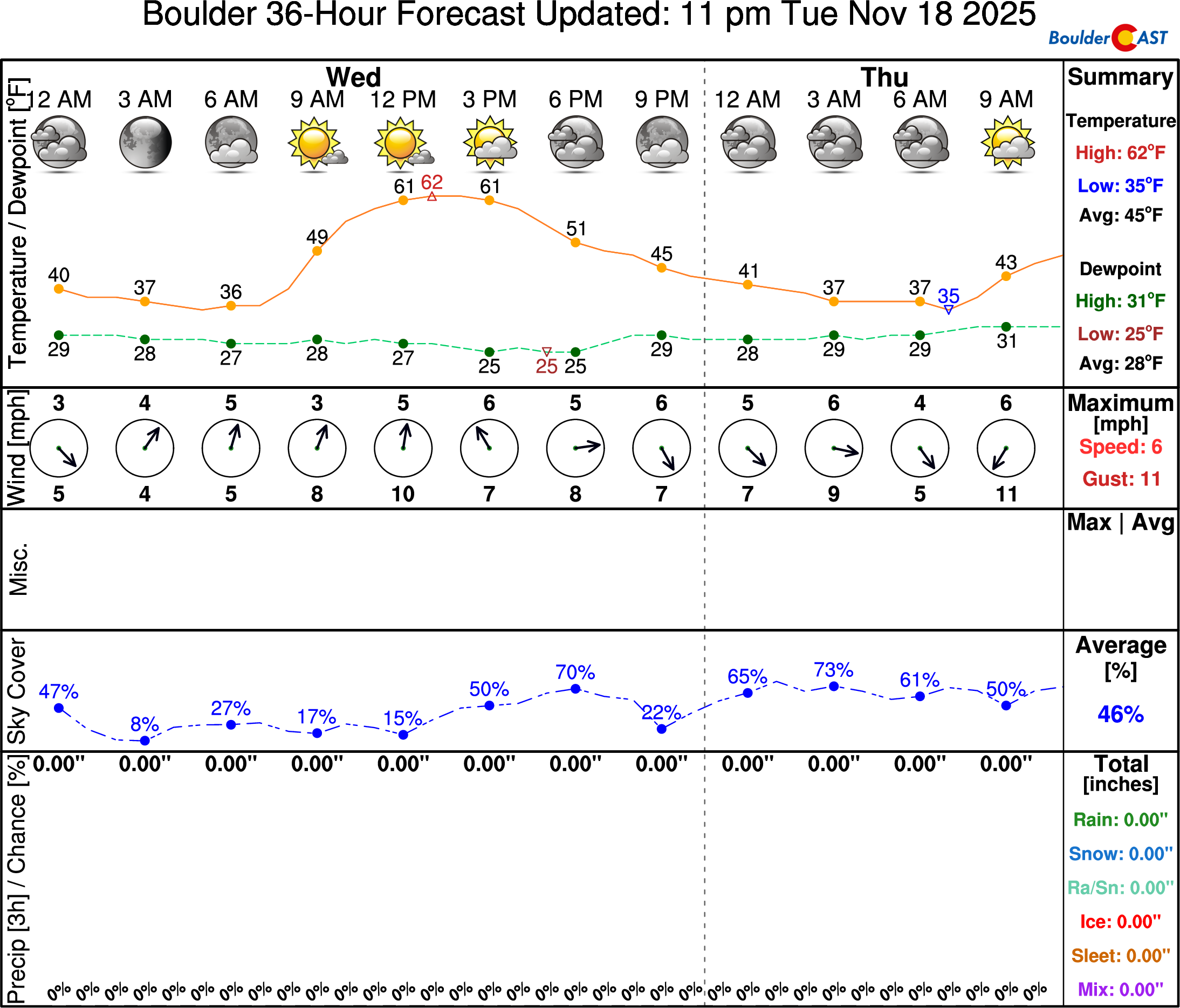
- Final mild day Wednesday: Sunshine dominates thanks to a narrow dry slot between two cloud streams; highs in the low–mid 60s.
- Storm setup: Cut‑off low near San Diego interacts with a stronger secondary West Coast low, creating a Fujiwhara effect that complicates the forecast.
- Thursday outlook: Cloud cover increases, highs capped in the lower 50s under partly to mostly cloudy skies.
- Precipitation timing: Rain most likely arrives between 6 PM and midnight Thursday as the low tracks across northern New Mexico and into position in southeast Colorado.
- Snow levels: Too warm for lower‑elevation snow; snow confined above ~7000 ft, possibly dipping to 6000 ft if colder solutions verify.
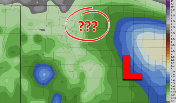
- Rain amounts uncertain: Boulder/Denver sit on the edge; ~0.25″ possible, up to 0.5″ east of I‑25, but model variability remains high.

Go Premium, get all the perks.
Daily Forecast Updates
Get our daily forecast discussion every morning delivered to your inbox.
All Our Model Data
Access to all our Colorado-centric high-resolution weather model graphics. Seriously — every one!
Ski & Hiking Forecasts
6-day forecasts for all the Colorado ski resorts, plus more than 120 hiking trails, including every 14er.
Smoke Forecasts
Wildfire smoke concentration predictions up to 72 hours into the future.
Exclusive Content
Weekend outlooks every Thursday, bonus storm updates, historical data and much more!
No Advertisements
Enjoy ad-free viewing on the entire site.
Wednesday Will Be Pleasant
Today looks to be the last truly mild and pleasant day before our incoming storm system begins to influence the area tomorrow. As of Wednesday morning, the cut-off low is parked near San Diego, barely budging from its position near Los Angeles yesterday. Ahead of this system, southwest flow continues to dominate over Colorado, pulling streams of moisture northward. On GOES-East infrared imagery, you can actually see two distinct bands of upper-level clouds—almost like twin conveyor belts of moisture. Conveniently, the Front Range sits in a narrow dry slot between them, which is why we’ll enjoy plenty of sunshine for our Wednesday.
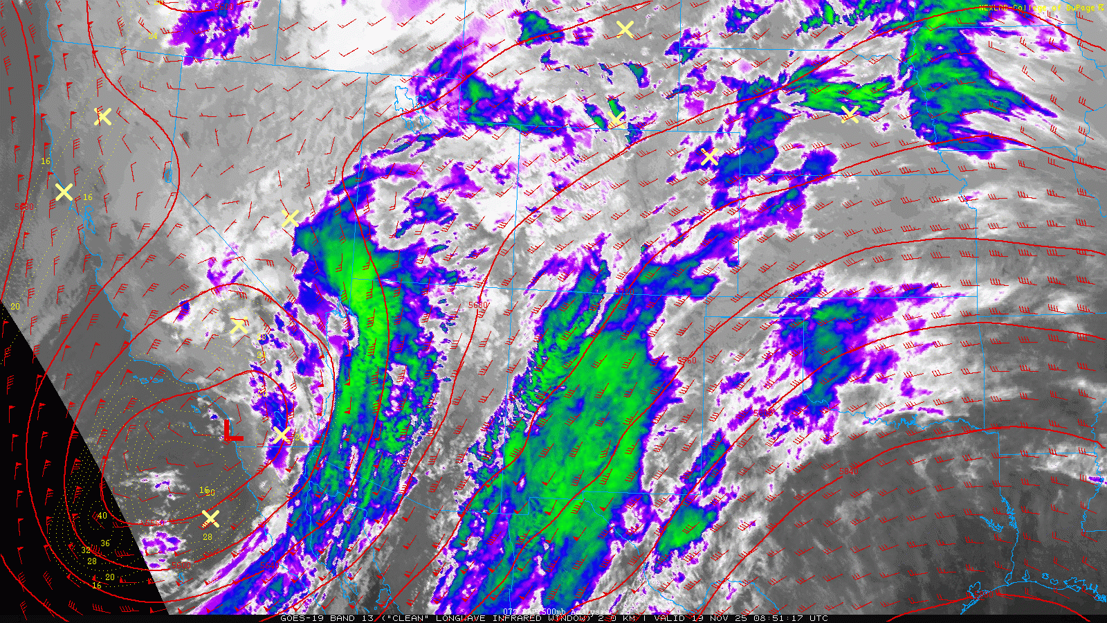
GOES-East infrared satellite animation from Wednesday morning
Temperatures will climb into the low to mid-60s again, very similar to yesterday. NowCAST is pegging Boulder at 62°, though given the sunshine, we wouldn’t be surprised to see readings a couple degrees warmer. Expect a mix of clouds and sun, but overall a very comfortable November afternoon.
A Complicated Storm Lies Ahead
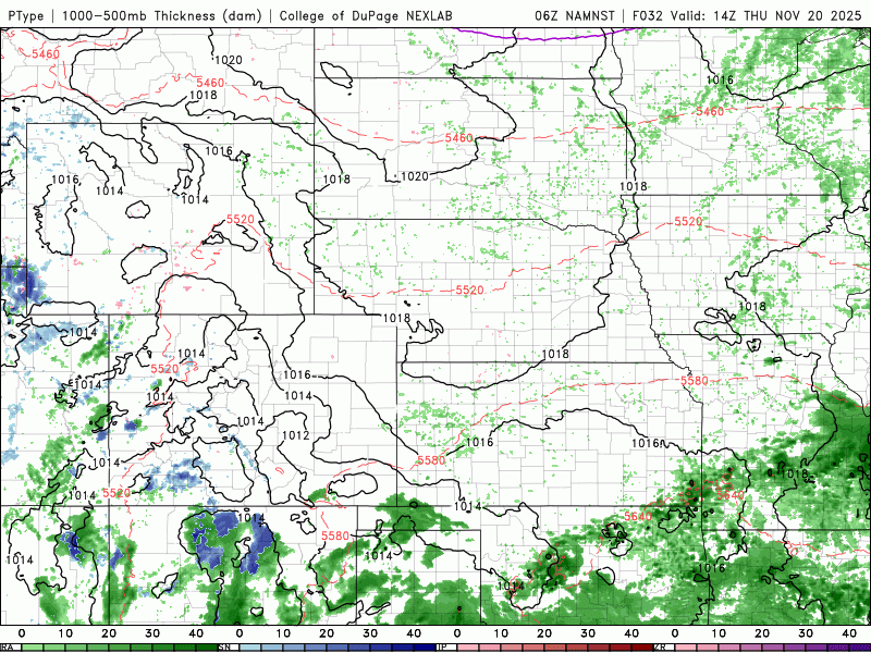
The forecast beyond today gets tricky. The track of our storm depends heavily on how it interacts with a stronger secondary cut-off low dropping down the West Coast. This interaction is a textbook example of a Fujiwhara effect—a phenomenon usually associated with tropical cyclones but applicable to any pair of nearby closed lows. In this case, the smaller storm (ours) will orbit around the larger one, weakening as it drifts east into the Oklahoma Panhandle by Friday morning. That dance between the two systems is why models are struggling to pin down precipitation amounts for the Front Range thus far. Each new run shifts the finer details, sometimes dramatically, and with our overall confidence remaining quite low still.
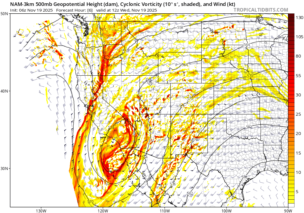
NAM-NEST 500mb height and vorticity forecast animation showing the interaction of the two low pressures through Friday afternoon
What We’re Confident About
- Thursday’s Weather: Expect a big uptick in cloud cover as the storm approaches. Highs will be capped in the lower 50s under mostly cloudy skies.
- Precipitation Onset: Rain chances increase Thursday evening as the low moves across northern New Mexico. The Boulder–Denver corridor should see precipitation commence sometime between 6 PM and midnight.
- Next to No Chance for Lower Elevation Snow: Temperatures will almost certainly be too warm for snow across the lower elevations. Snow levels likely stay above 7000 feet, but may drop down to 6000 feet if colder solutions verify.
- Precipitation Amounts: Still highly uncertain. The strongest signal is for heavier precipitation south and east of Denver, possibly toward the Kansas border. Boulder and Denver sit right on the edge, so totals could vary widely. Current thinking: ~0.25″ of rain is a reasonable expectation, with up to 0.5″ possible east of I-25. But lower totals remain just as plausible.
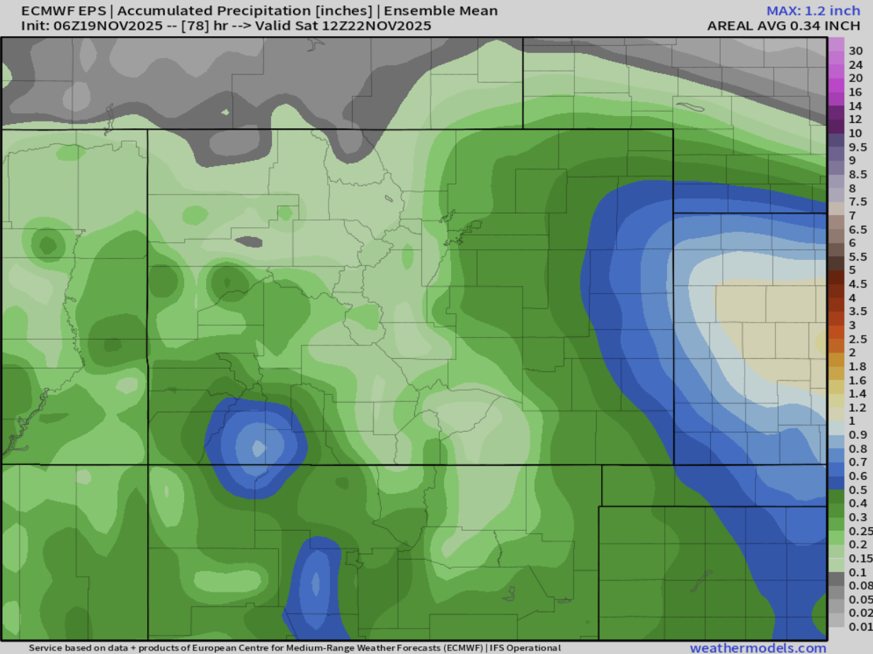
Euro ensemble mean precipitation forecast for Colorado
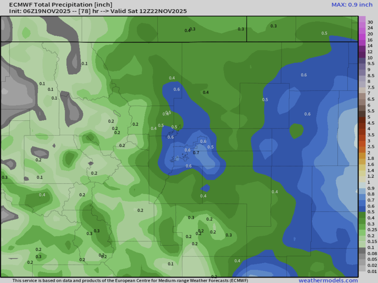
Latest run of the operational Euro precipitation forecast for Denver area
We Need Any and All Moisture
Any moisture will be welcome. Boulder County has already seen two small wildland fires in the past week. Both were quickly contained but this underscores how dry our vegetation is right now. Even a quarter inch of rain would help dampen fuels and reduce fire risk heading into late November.
Hopefully we get more clarity later today as the short-range guidance starts to get a look at the full extent of the storm. Still, given the complexity of this setup, we don’t expect all the uncertainty to vanish that easily. We’ll refine the details in tomorrow’s update. Stay tuned.
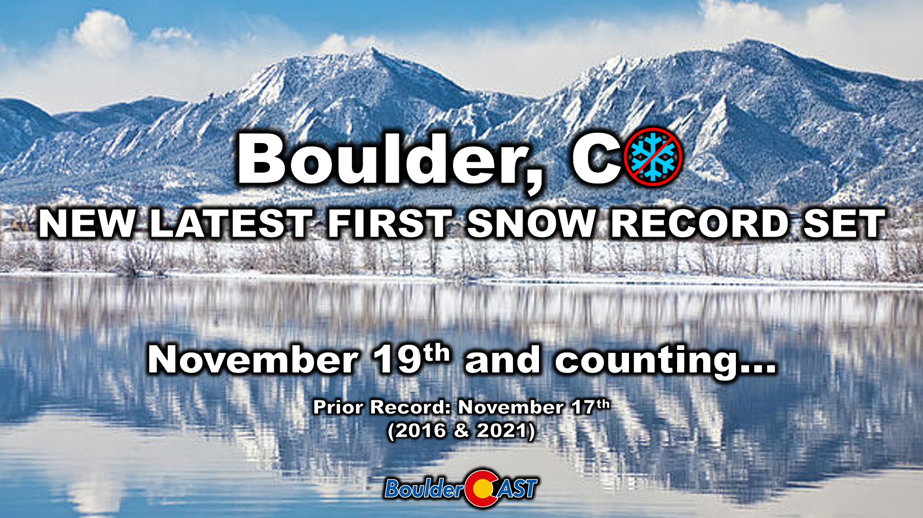
P.S. Yes, we have broken the record for the latest first snow in Boulder: November 19th and counting. With only rain expected from this incoming storm, our next chance for snow will not be until early next week.
Sadly, this means it ended up snowing in Hawai’i this year before Boulder and Denver!
Spread the word, share our crazy Colorado weather:
Go Premium, get all the perks.
Daily Forecast Updates
Get our daily forecast discussion every morning delivered to your inbox.
All Our Model Data
Access to all our Colorado-centric high-resolution weather model graphics. Seriously — every one!
Ski & Hiking Forecasts
6-day forecasts for all the Colorado ski resorts, plus more than 120 hiking trails, including every 14er.
Smoke Forecasts
Wildfire smoke concentration predictions up to 72 hours into the future.
Exclusive Content
Weekend outlooks every Thursday, bonus storm updates, historical data and much more!
No Advertisements
Enjoy ad-free viewing on the entire site.


You must be logged in to post a comment.