Recent monsoon rains have brought some improvement in the ongoing drought across our area. However, the weather this week in the Front Range will largely be focused around the passage of a couple dry cold fronts with minimal rainfall expected. Although temperatures will fluctuate from the upper 70s to the lower 90s at times, most of the week will hover near or slightly above normal. As we head into the upcoming holiday weekend, storm chances will increase somewhat as moisture-rich flow tries to re-exert itself over our area. All this and more in our latest weekly outlook!
This week’s highlights include:
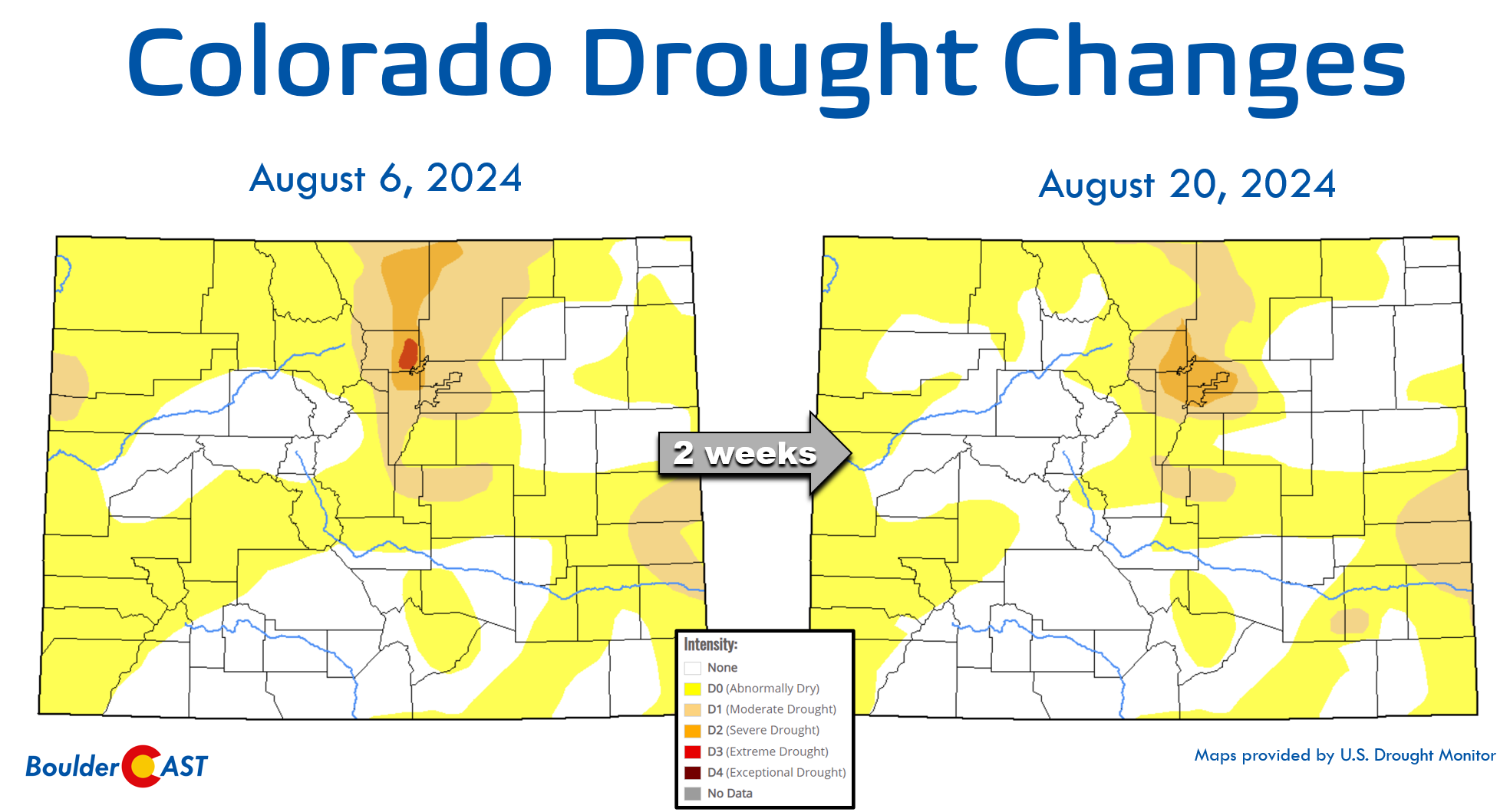
- Selective Drought Improvement: Recent wet weather the last few weeks has improved drought conditions over parts of Boulder and Larimer Counties, but Denver has worsened…
- Little to No Rain: Rain chances are minimal through much of the work week with a series of (mostly) dry cold fronts impacting the Front Range.
- Fluctuating But Seasonal Temperatures: Temperatures will hover on either side of normal for us, with the warmest day being Wednesday and coolest Thursday.
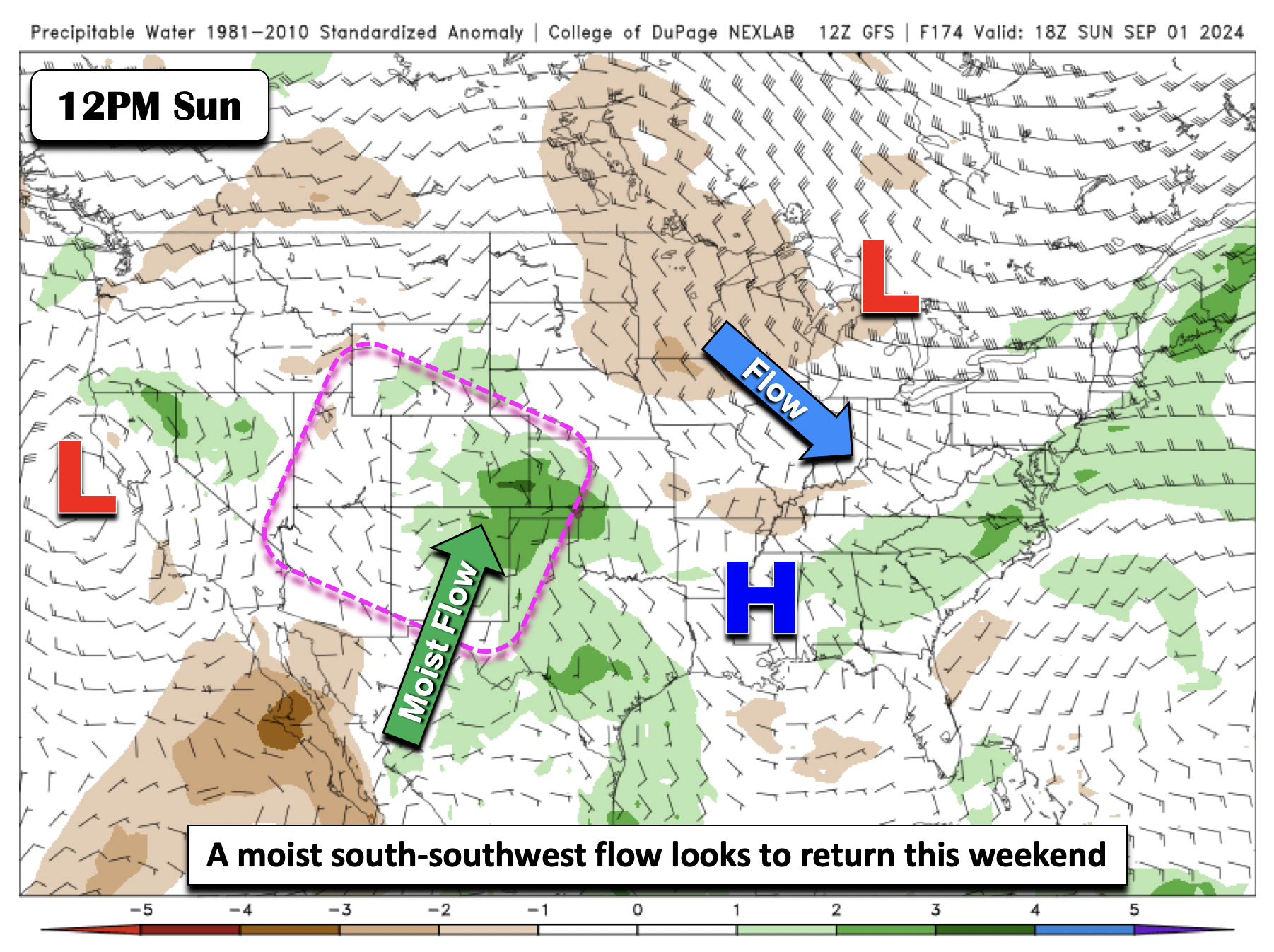
- A Wetter Labor Day Weekend Ahead: Moist south-southwest flow will re-exert itself late in the upcoming weekend favoring an uptick in storm chances Sunday into early next week.
DISCLAIMER: This weekly outlook forecast is created Monday morning and covers the entire upcoming week. Accuracy will decrease as the week progresses as this post is NOT updated. To receive daily updated forecasts from our team, among many other perks, subscribe to BoulderCAST Premium.

Go Premium, get all the perks.
Daily Forecast Updates
Get our daily forecast discussion every morning delivered to your inbox.
All Our Model Data
Access to all our Colorado-centric high-resolution weather model graphics. Seriously — every one!
Ski & Hiking Forecasts
6-day forecasts for all the Colorado ski resorts, plus more than 120 hiking trails, including every 14er.
Smoke Forecasts
Wildfire smoke concentration predictions up to 72 hours into the future.
Exclusive Content
Weekend outlooks every Thursday, bonus storm updates, historical data and much more!
No Advertisements
Enjoy ad-free viewing on the entire site.
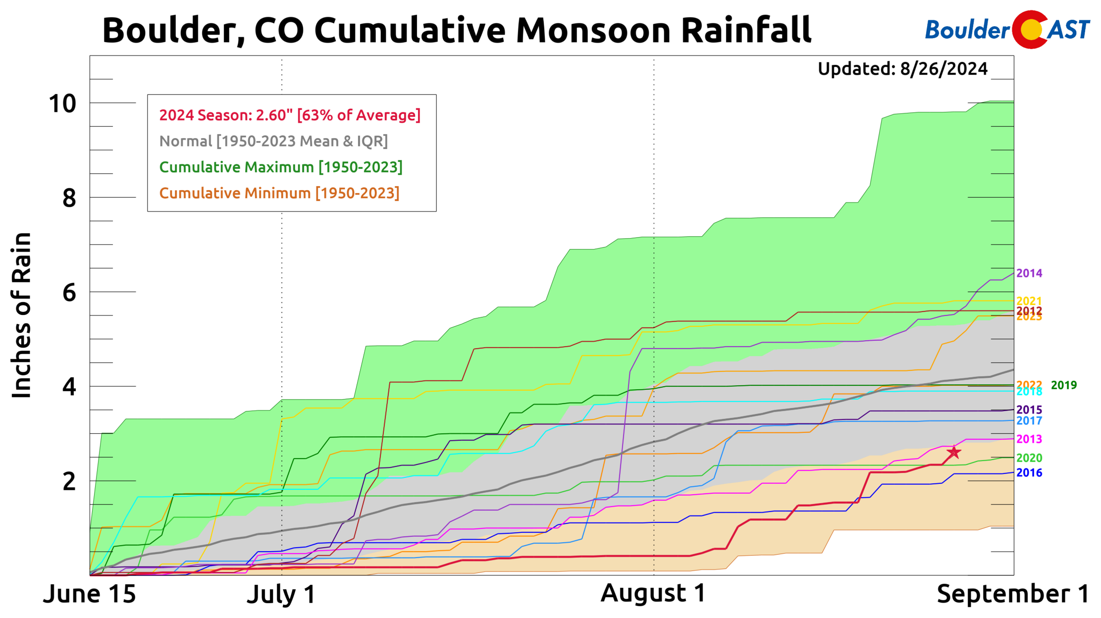
Late-season monsoon has helped the drought in some areas
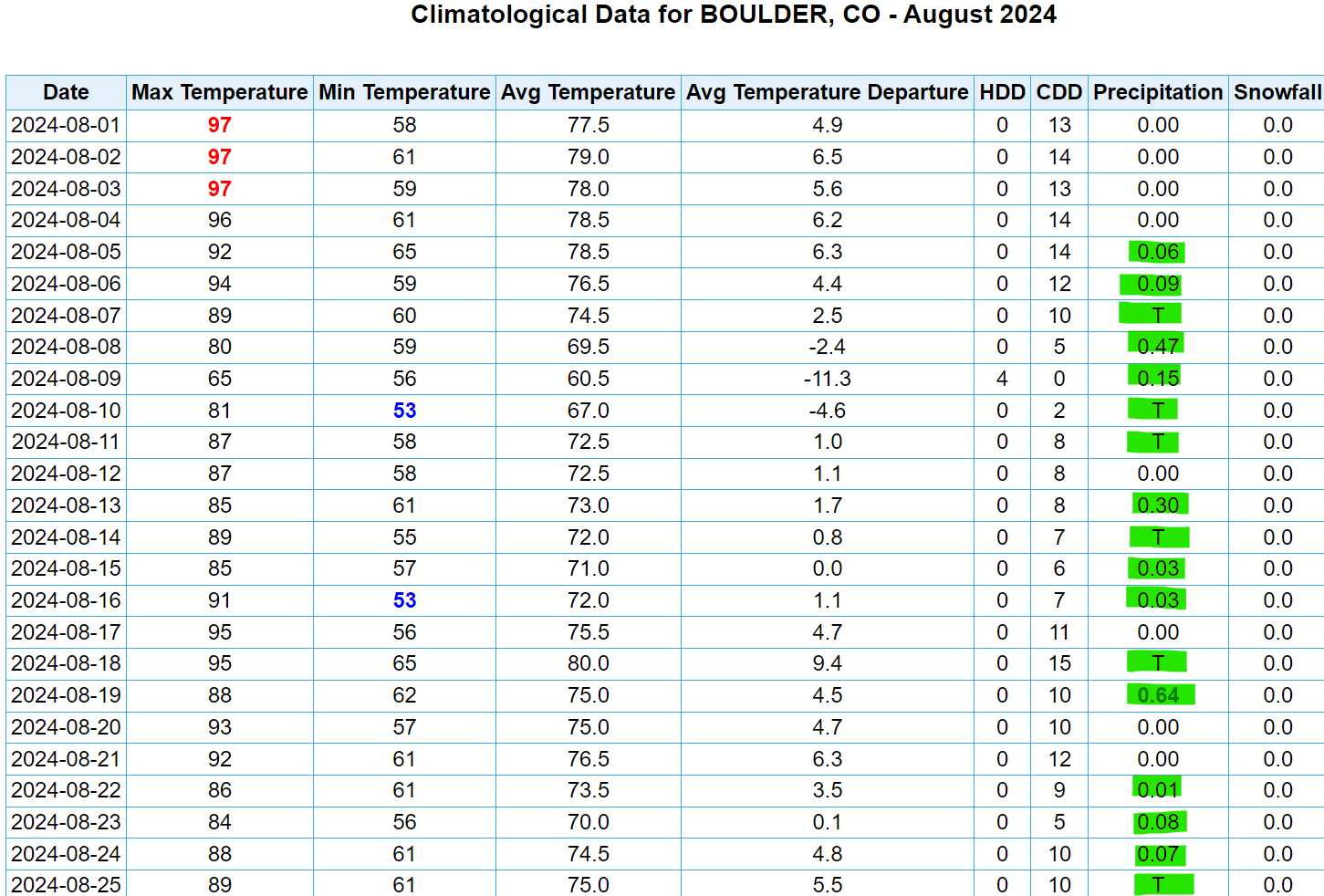
Despite the historically dry late spring and summer in Boulder, a late-season push by the monsoon has delivered a more normal amount of rainfall to the region in August — even above normal in some cases. Officially, rain has occurred in Boulder 17 out of the last 21 days, totalling 2.19″ of rainfall month-to-date (including widespread light rain that fell last night).
The somewhat soggy last few weeks in the Front Range has brought positive news regarding the ongoing local drought, with the previously bone dry portions of Boulder and Larimer Counties showing at least one or two categories of improvements. However, drought in the core of the Denver Metro area has worsened though where rain has been more scarce in August. The worst drought in Colorado is now squarely centered over Denver and Boulder.
Unfortunately, as you will soon see, the recent wetter trend will not continue for the upcoming week with only minimal chances to see additional rainfall as August comes to a close.
A largely dry week with temperatures on either side of normal
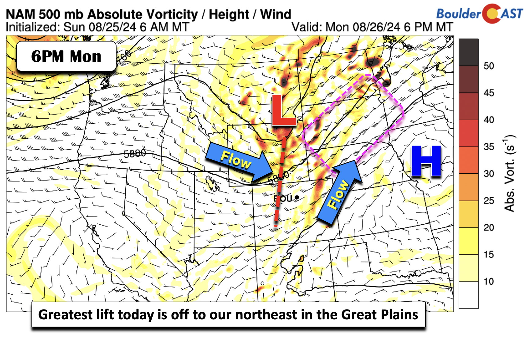
Rain chances this week will be fairly minimal across the Front Range. However, that does not mean that the weather at mid-levels will be quiet. On the contrary, it will be fairly active and transient with a series of troughs set to influence our weather throughout the week. The first trough impacts us on Monday. It’s location will be across eastern Montana and northeastern Wyoming by Monday afternoon. The main axis of lift with the trough will be well to our east, centered on northern Nebraska and over South Dakota.
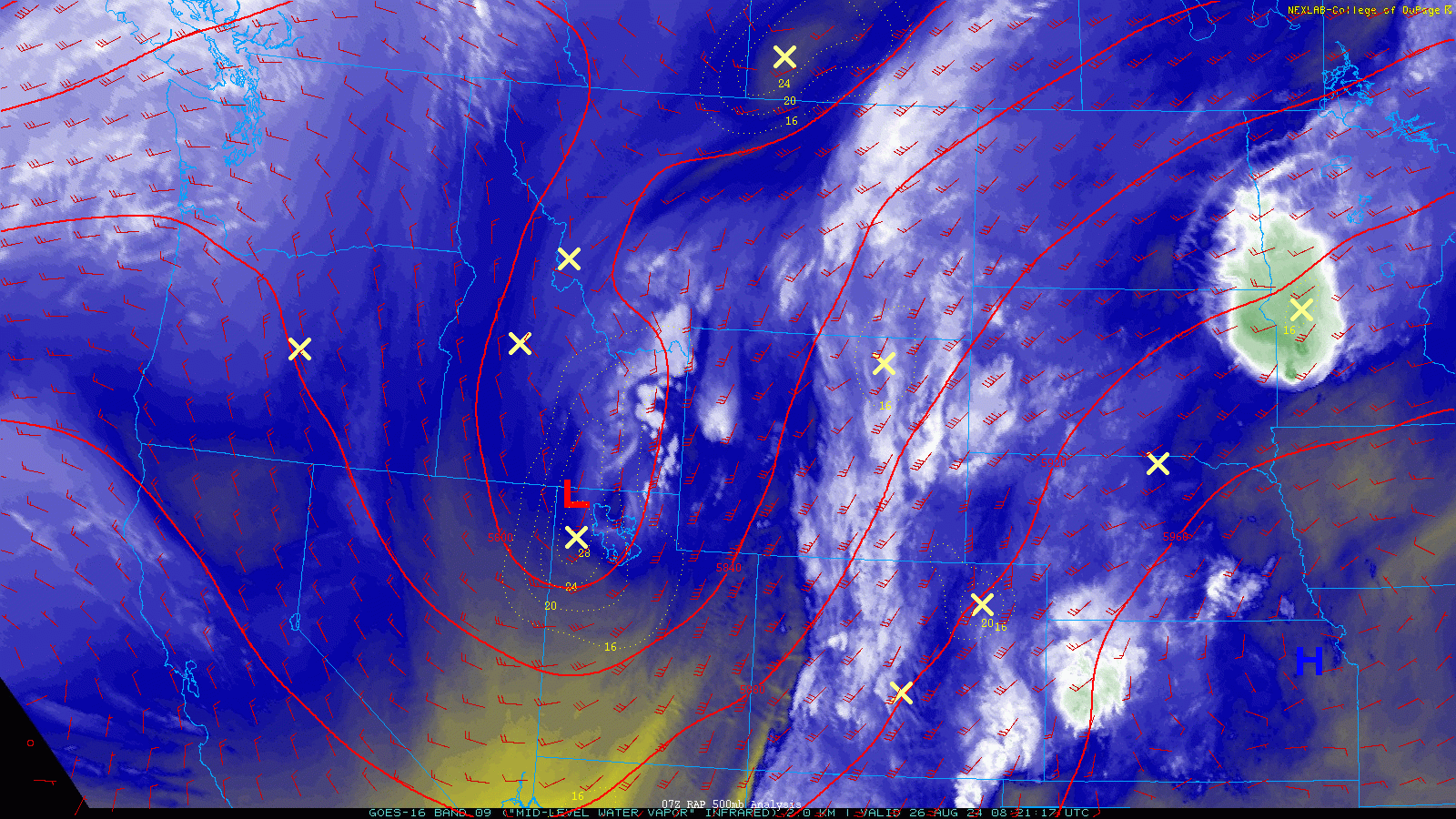
This vigorous shortwave can been seen just north of Salt Lake City in the GOES-East water vapor animation below from Monday morning. This is the the same storm system which brought accumulating summer snow to the higher elevations of California a few days ago.
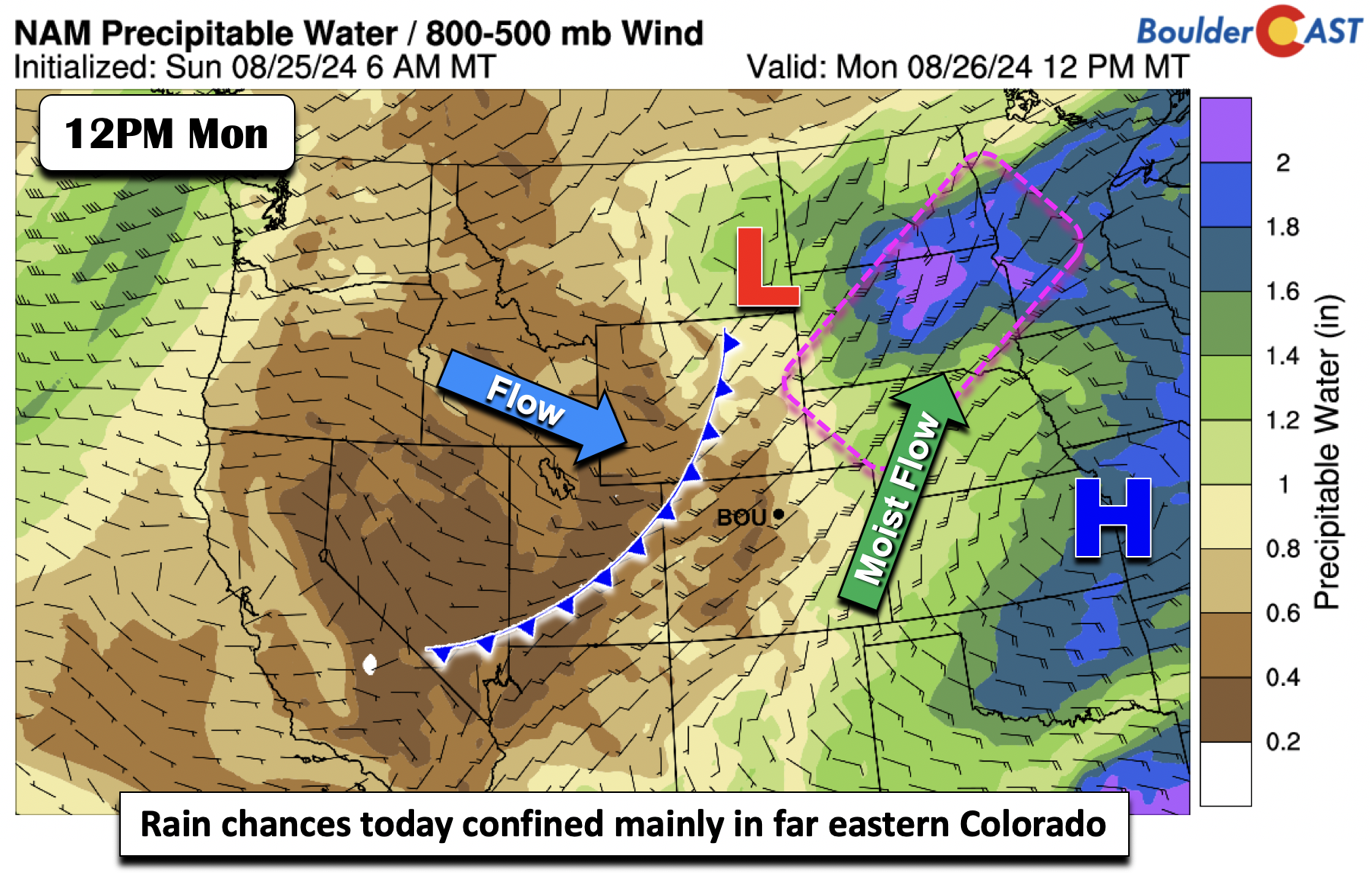
Deep moisture transport will also collocate over the Dakotas with the greatest mid-level energy, where precipitable water values exceed 2 inches. Over Colorado, the moisture belt will largely reside over far eastern Colorado. Drier air will be present from central to western Colorado, with precipitable water values near 0.5 inches or lower. A cold front will initiate storms to its east, but mainly across the central and northern Great Plains, leaving us largely dry on Monday. The front moves through overnight Monday night.
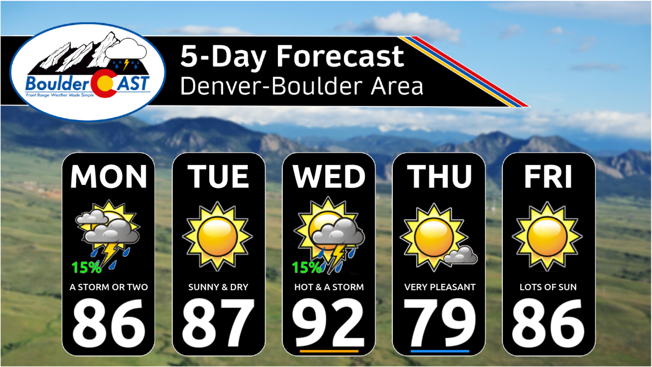
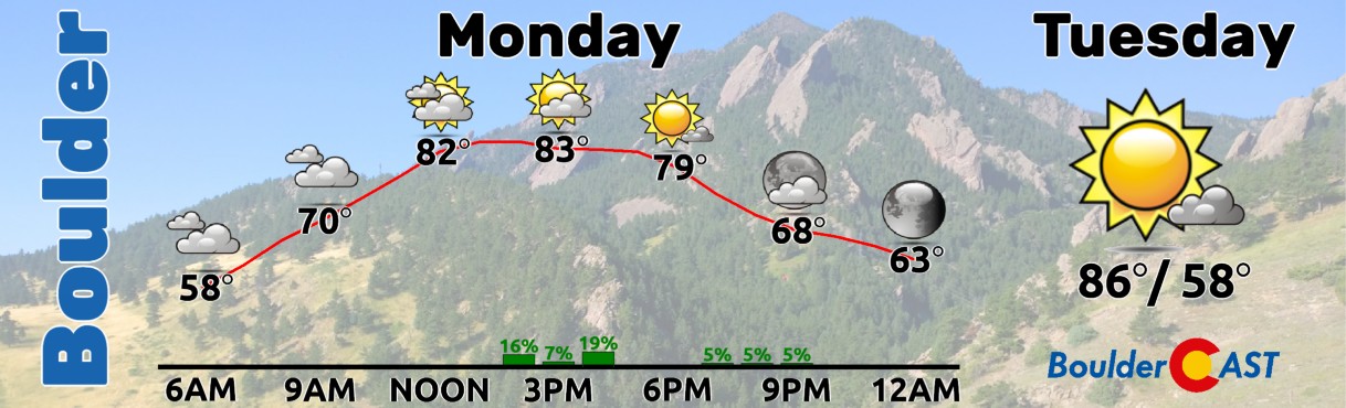
For Monday, we’ll see highs in the mid to upper 80s, with only about a 10-20% chance of some afternoon isolated storms.
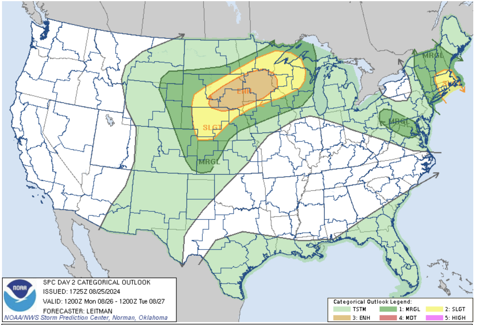
The Storm Prediction Center has an Enhanced Risk of severe storms over the Dakotas and Upper Mississippi Valley. This is tied to the strong shear collocated with deep moisture and instability ahead of the cold front. Damaging winds and hail are the primary threats in this area, but tornadoes cannot be ruled out. A couple storms may also turn severe in eastern Colorado, mostly out near the Nebraska border.
Tuesday’s weather will be quiet. The airmass behind the front isn’t really that much colder. As a result, highs Tuesday will be similar in the mid to upper 80s, slightly above our seasonal normals which are the middle 80s.
Come Wednesday, a secondary but more vigorous trough will make its way into a very similar region as the one prior, over the Montana and lower Canada domain. Another cold front will be tied to this trough, with the front forecast to move through the Denver Metro area late Wednesday night or early Thursday.
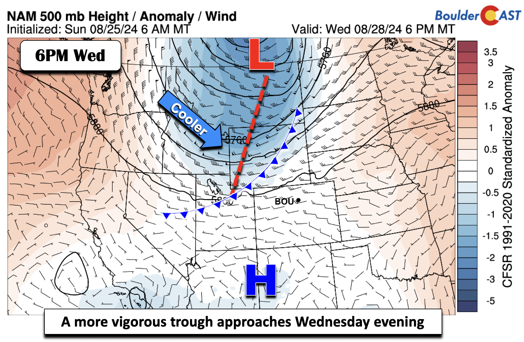
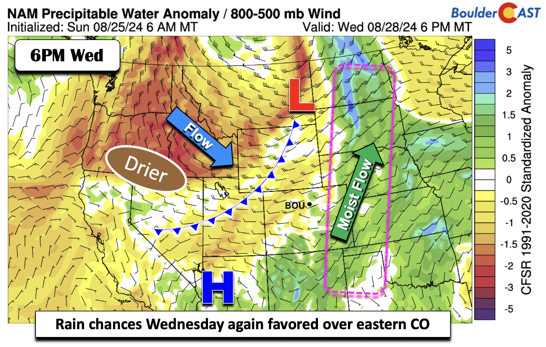
Much of what happens on Wednesday will be similar to that on our Monday. That is, the main moisture axis will be confined from Kansas to Nebraska to the Dakotas. This setup will leave Colorado in between this moist region and drier air advecting in behind the cold front (Idaho, Montana, and Oregon/Washington). We still are forecasting a 10-20% chance of some storms, but they will be few and far between, unless there is a dramatic shift in the forecast pattern. Wednesday should be our hottest day of the week with warm advection well in-place ahead of the front. Highs in the lower 90s are expected.
By Thursday and Friday, the cold front will be well south of us and things will be very quiet in the Boulder-Denver area. Thursday’s highs will be the coolest of the week, slightly below normal in the upper 70s to lower 80s. Dry weather should continue as sinking air and less overall moisture stymies any storms. The one exception would be over south-central Colorado, where the front may linger for isolated coverage. The next five days of weather sure do look great!
An uptick in storms this weekend?
Heading into the weekend, although there is some uncertainty this far out, most ensemble data is indicating that some form of a trough will be present off the California coast. At the same time, a ridge will be loosely centered over the Deep South. Troughing will reside over the Great Lakes to Ohio Valley into the Northeast US. For Colorado, this pattern would lead to a more south to southwest flow which would favor storms returning to the forecast as Pacific moisture tries to encroach on the area. There could even be some weak tropical waves embedded in the flow.
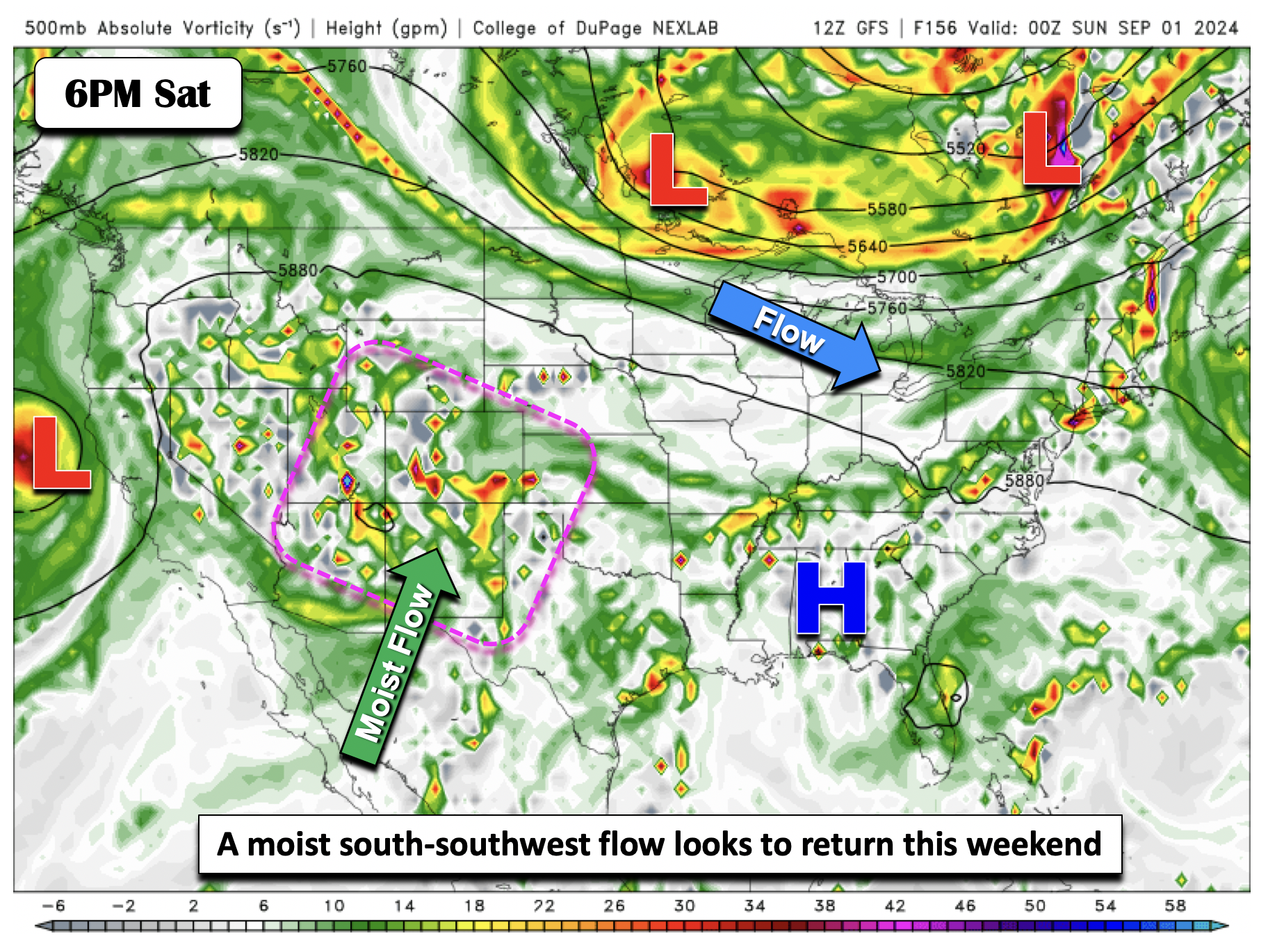
Moisture anomalies will trend toward the positive side, at no surprise, especially late in the upcoming weekend. As a result, we should see an uptick in storm chances, especially for Sunday into early next week — not great news for those planning outdoor activities for Labor Day Weekend. Temperatures will be seasonal in the 80s at least.
Enjoy the gorgeous weather this week!
Forecast Specifics:
Monday: Partly cloudy with a 10-20% of a few isolated storms. Main storm action will be well east of the Denver Metro where one or two storms may turn severe. Highs in the mid to upper 80s on the Plains and mid to upper 70s in the Foothills.
Tuesday: Mostly sunny with highs in the mid to upper 80s for the Plains and mid to upper 70s in the Foothills.
Wednesday: Increasing clouds with a 10-20% chance of afternoon storms. Highs in the lower 90s on the Plains and lower 80s across the Foothills.
Thursday: Mostly sunny and notably cooler with highs around 80 degrees on the Plains with upper 60s in the Foothills.
Friday: Lots of sunshine and near normal with highs in the middle 80s for the Plains and lower 70s in the Foothills.
Weekend: Rain and storm chances will increase, especially Sunday into early next week. High temperatures for the Plains look to be in the 80s with 70s in the Foothills.
Get BoulderCAST updates delivered to your inbox:
DISCLAIMER: This weekly outlook forecast is created Monday morning and covers the entire upcoming week. Accuracy will decrease as the week progresses as this post is NOT updated. To receive daily updated forecasts from our team, among many other perks, subscribe to BoulderCAST Premium.
Go Premium, get all the perks.
Daily Forecast Updates
Get our daily forecast discussion every morning delivered to your inbox.
All Our Model Data
Access to all our Colorado-centric high-resolution weather model graphics. Seriously — every one!
Ski & Hiking Forecasts
6-day forecasts for all the Colorado ski resorts, plus more than 120 hiking trails, including every 14er.
Smoke Forecasts
Wildfire smoke concentration predictions up to 72 hours into the future.
Exclusive Content
Weekend outlooks every Thursday, bonus storm updates, historical data and much more!
No Advertisements
Enjoy ad-free viewing on the entire site.
Enjoy our content? Give it a share!


You must be logged in to post a comment.