
An impending pattern shift is expected to bring record-breaking triple-digit temperatures to the Front Range this weekend. This latest round of extreme heat is due to a superheated airmass moving into Colorado from the Desert, an airmass which has already produced all-time record highs in other western states. We review the climatology for rare triple digit heat, discuss why Denver is often several degrees warmer than Boulder during the summer, go over the forecast for just how hot it will get this weekend and look ahead to when we may finally cool off.
Key Highlights from This Post:
- Heat Dome Spreads Eastward: A superheated airmass that has been bottled up under high pressure along the West Coast since late June will spread into Colorado beginning Thursday
- Triple Digit Heat: Boulder and Denver are expected to experience several days of triple-digit temperatures this weekend, with record highs likely to be tied or broken.
- Heat Advisories Posted: A Heat Advisory is in effect for the Denver Metro area and northern Front Range from Friday into Sunday.
- Air Quality Will Decline: Elevated ozone levels and increasing wildfire smoke will make this weekend especially dangerous for sensitive groups when combined with the extreme heat.
- Cooling Trend & Rain Chances Early Next Week: While we won’t see a significant cold front arrive to crack this heatwave, slightly cooler temperatures will unfold Monday into next week with highs falling back into the 90s and chances for rain returning
Help support our team of Front Range weather bloggers by joining BoulderCAST Premium. We talk Boulder and Denver weather every single day. Sign up now to get access to our daily forecast discussions each morning, complete six-day skiing and hiking forecasts powered by machine learning, first-class access to all our Colorado-centric high-resolution weather graphics, bonus storm updates and much more! Or not, we just appreciate your readership!

Why will it be so hot?
As foreshadowed in our weekly outlook posted back on Monday, cities up and down the Front Range will have an excellent chance to reach triple-digit temperatures this weekend, perhaps even across multiple days in some cities, as a dominant ridge of high pressure builds into Colorado from the west. This pattern shift can be seen in the European ensemble 500mb height anomaly forecast animation below. Notice that the center of the ridge sits near Las Vegas right now and also how it will wobbles eastward into Utah by Saturday and eventually into southwest Colorado by Sunday.
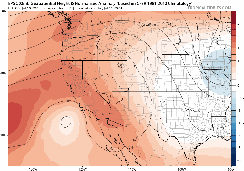
This high pressure center has already been responsible for the breaking of numerous ALL-TIME record high temperatures to our west, including places like:
- Palm Springs, California: 124°F on Friday July 5th
- Las Vegas, Nevada: 120°F on Sunday July 7th
- Reading, California: 119°F on Sunday July 7th
- Honorable Mention: Death Valley, California: 129°F on Sunday July 7th (one degree shy of the all-time record high for PLANET EARTH)
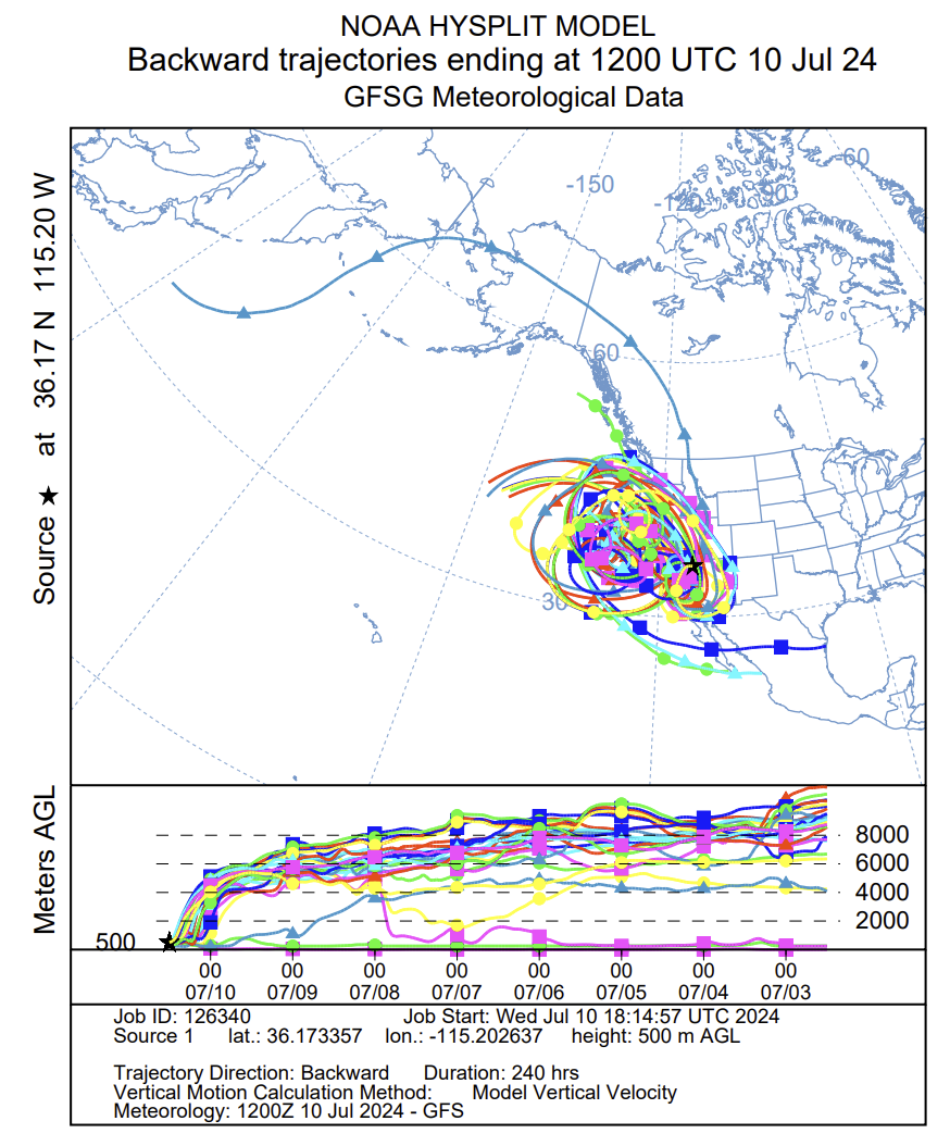
The “heat dome” sitting under this ridge has garnered exceptional warmth due to it remaining essentially stationary since late June in one of the most scorching hot parts of the country. This has allowed the airmass to linger for two long weeks in dry and subsident conditions with limited cloud cover. The stagnant airmass warmed up slightly each successive day of sunshine, with only minimal mixing occurring with nearby, cooler airmasses. The graphic below shows a backward trajectory analysis for the air currently sitting over Las Vegas — each colored line is a run from a separate model ensemble member. By using a combination of atmospheric observations and ensemble model data from the previous days, we can determine where the air over Las Vegas has been in recent times. This trajectory analysis shapes a telling story — the airmass has been swirling clockwise along the West Coast and Desert Southwest for at least the last TEN days. It looks like a giant spiraling spider web!
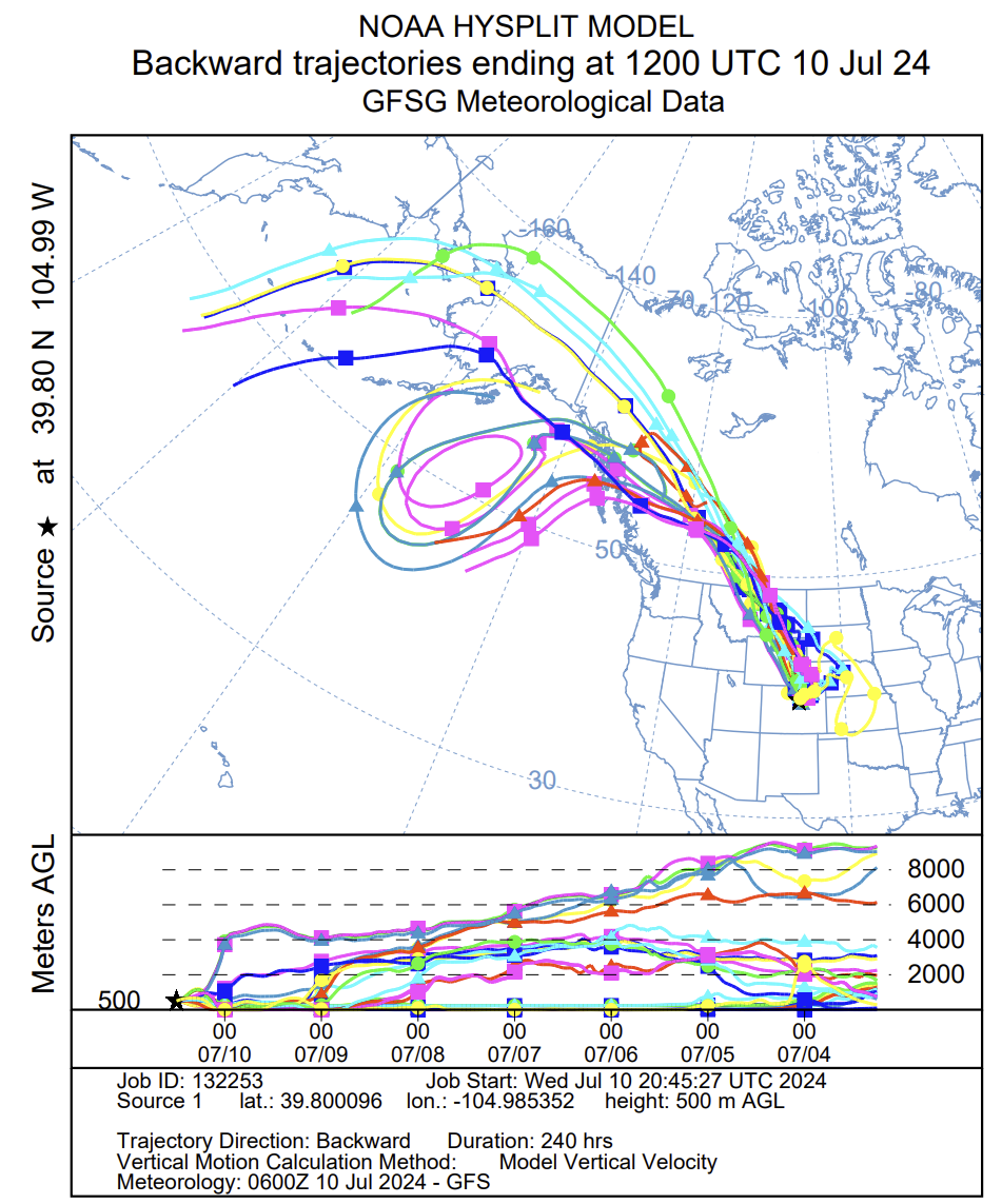
This prolonged swirling of air is far from a typical situation. For example, below is the backward trajectory analysis for the air over Denver on Wednesday. The “cool” airmass we had yesterday was previously found in the Bering Sea and the Gulf of Alaska about ten days prior. That’s a fairly normal situation. Of course the air coming our way from Alaska would moderate slowly as it moved to lower latitudes and gets entrained with air from other areas.
How will this record-setting, hot blob of air moving eastward into Colorado impact the Front Range the next few days? Let’s take a look…
Historical heatwaves and our forecast for this one
First, just for some context, the hottest temperature so far in 2024 in Boulder was 99°F reached back on June 13th…
'Twas a new record high in Boulder on Thursday, 99°F 🔥 #COWx #Boulder #Boulderwx pic.twitter.com/bXSTZRY5vM
— BoulderCAST Weather 🏔️❄️ (@BoulderCAST) June 15, 2024
…while the hottest temperature in Denver this summer was 100°F back on June 25th, a day when Boulder only reached 98°F. It may come as a surprise, but Boulder is almost always cooler than Denver during the summer months, usually by several degrees. There are a few notable reasons for this temperature shortcoming:
- CLOUDS: Summertime cumulus clouds and storms routinely build over Boulder earlier in the day than Denver as they almost always initiate over the higher terrain first and move eastward. This allows Denver to capitalize on more solar heating during the late morning and early afternoon.
- ELEVATION: Boulder is slightly higher in elevation than Denver, which has cooling implications in the daytime. For summer heat, lower elevation is better. Just look at Death Valley!
- TERRAIN PROXIMITY: Boulder’s closeness to the Foothills tends to produce a weak upslope breeze during summer mornings which has a slight cooling effect. As the sun rises to the east, it strikes the eastern slopes of the Foothills/Mountains at the most efficient angle. This creates what is known as a valley breeze which is similar to a sea breeze. Both are created due to differential heating of two nearby locations. It’s not until around midday that the sun rises high enough to reduce the differential heating and kill off the valley breeze.
- HEAT ISLAND EFFECT: Denver has extensive urban development with dense buildings, roads and infrastructure which creates a strong heat island effect due to land use changes. Sure, Boulder is also dense, but it is on a smaller scale than Denver as the city is surrounded by miles of open space on all sides.
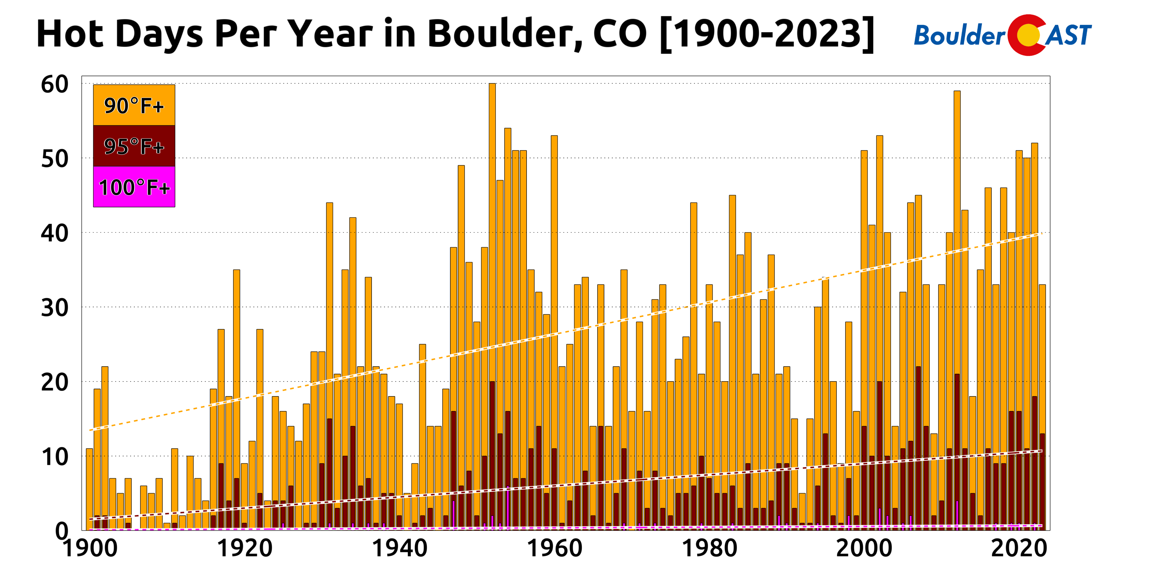
While Denver averages almost one 100-degree day per year, Boulder sees only about one every two years. As shown in the graphic below, there have been 37 100°+ days in the last 74 years in Boulder. The most common window for triple digit heat is from late June through late July, but they have been known to occur as early as June 12th and as late as September 2nd (twice!). Our most recent 100°F day was back July 19, 2022 — so we are about due!
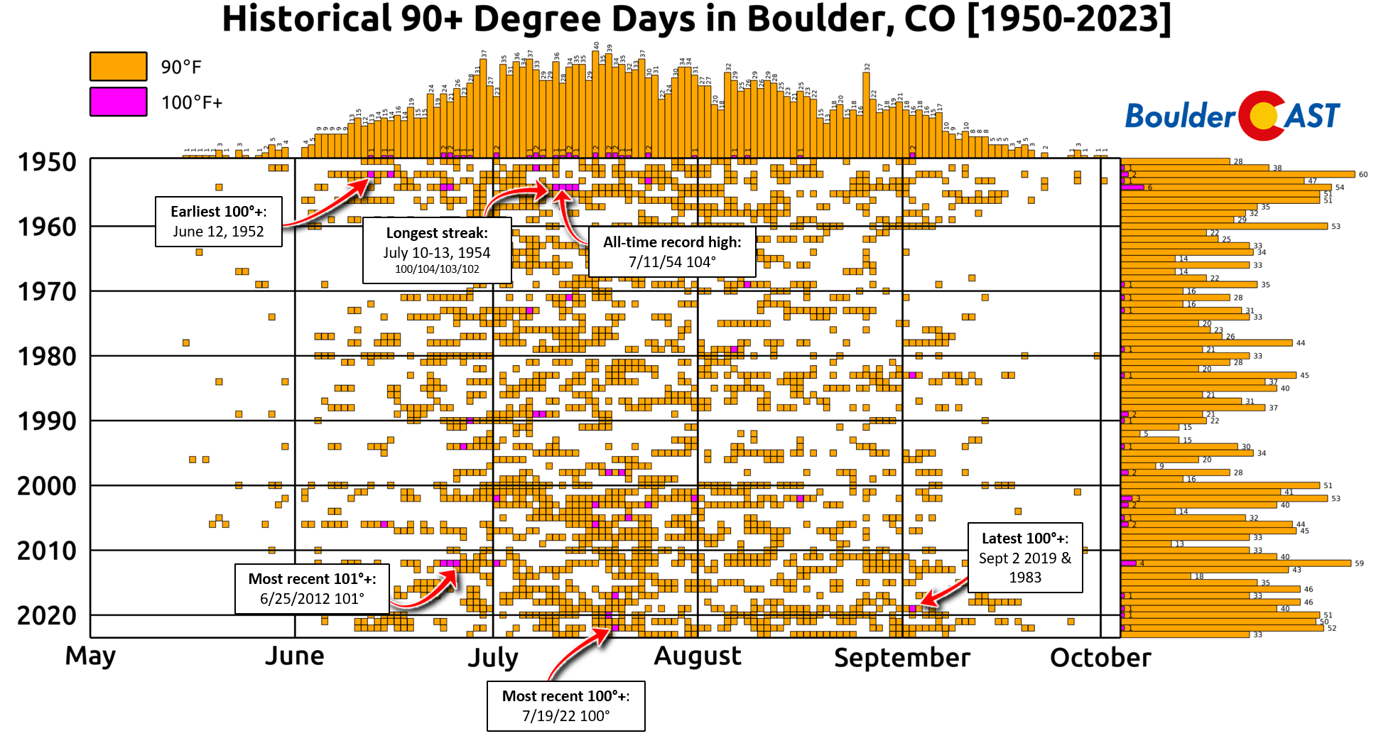
Click to enlarge!
Shockingly, it’s been more than 12 years since the city last hit 101°F — that happened the day before the Flagstaff Fire ignited in the brutally hot and dry June 2012.
🔥Today is the 11 year anniversary of the Flagstaff Fire in #Boulder. It was sparked by a monsoon lightning strike amidst a terrible statewide drought. In the end, the wildfire burned about 350 acres and forever changed the landscape of Bear and South Boulder Peaks! #COWx pic.twitter.com/Cl69x1bZPs
— BoulderCAST Weather 🏔️❄️ (@BoulderCAST) June 26, 2023
As you’d undoubtedly expect, the number of hot days in Boulder is indeed increasing through the decades as our planet warms. The early 1900s usually had 10 to 20 90-degree days each summer — now we’re lucky to see less than 35!
Let’s move into the forecast!
As expected, temperatures have been creeping up a few degrees each day this week, and that trend will continue into Thursday and Friday as the anticipated “heat dome” edges into Colorado. Highs Thursday will reach towards uncomfortable territory into the middle 90s.
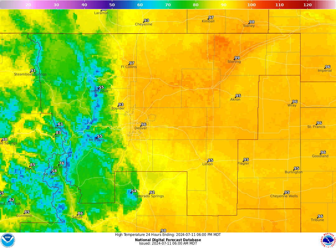
Forecast highs on Thursday July 11th
It’s not until Friday, though, that the truly hot airmass will arrive from the west-southwest. As it does so, we will make a run at 100 degrees across all of eastern Colorado, including Boulder and Denver. There is a chance some areas only reach the upper 90s, though.
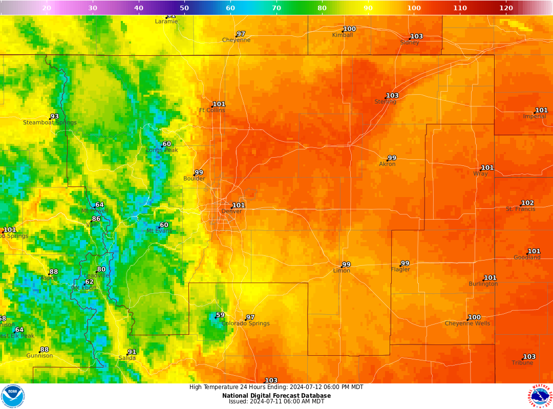
Forecast highs on Friday July 12th
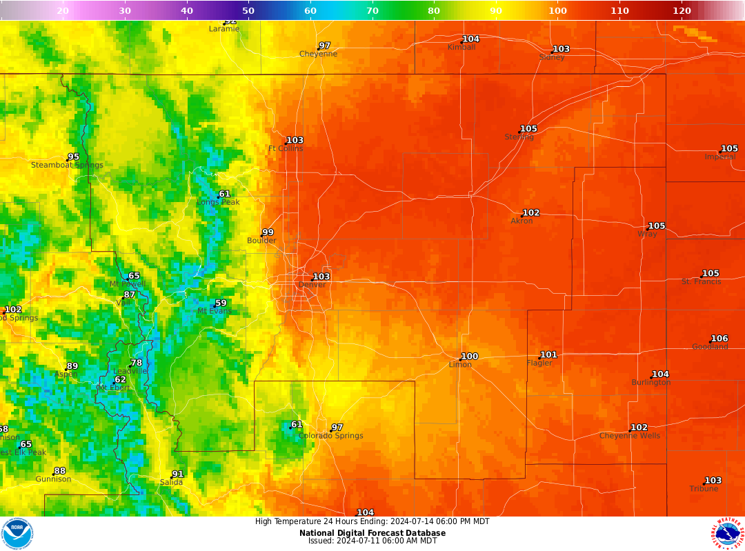
The prolonged heatwave will maximize over the upcoming weekend for northeast Colorado. Almost every city is expected to reach triple digits both days. Anywhere between 100 and 105°F will be commonplace Saturday and Sunday.
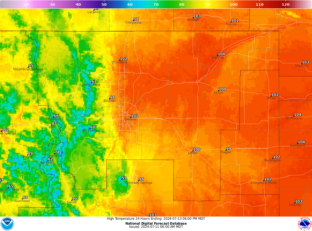
Forecast highs on Saturday July 13th
Forecast highs on Sunday July 14th
On Monday we will begin to see the longstanding ridge weaken slightly and split into two parts. Notice below how much weaker the ridge signature will be on Monday compared to Saturday:
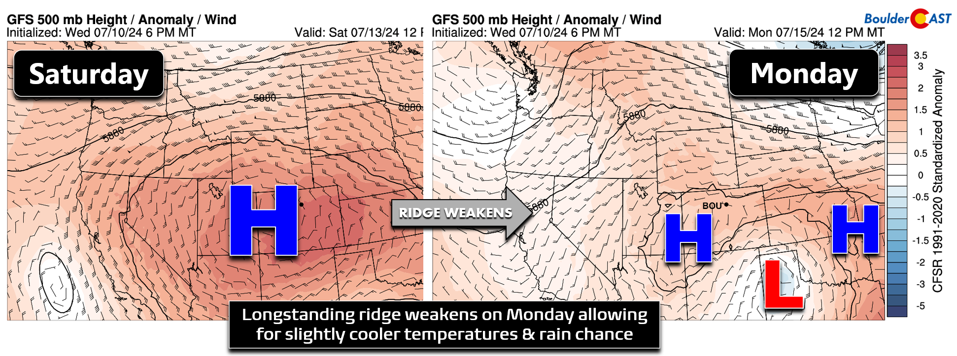
The weakening ridge (and return of some moisture to the area) will allow for more clouds and some storms to develop late on Monday. In addition to the rain chance, the net result will be slightly cooler temperatures on Monday, but don’t celebrate that statement too much. We will still be well above normal in the mid to upper 90s with isolated late-day storms.
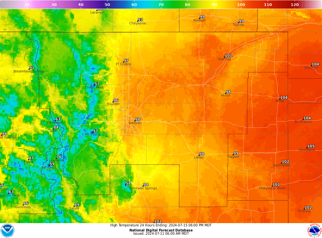
Forecast highs on Monday July 15th
Beyond Monday, the ridge is expected to weaken further, but we want to be clear here — there is no magical cold front in the pipeline coming to fully end this heatwave. Yes, we will begin to turn cooler Monday and into the next week, mainly a product of increased clouds and storms, but temperatures are likely to remain above normal throughout all or most of next week as well with highs generally staying in the 90s.
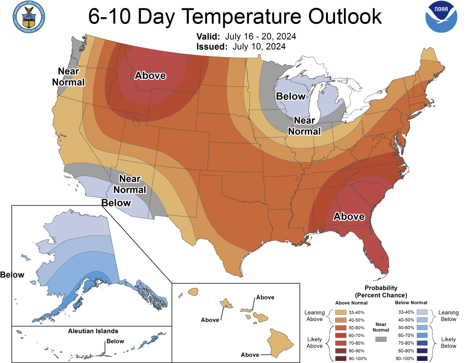
This continued heat in the long-range forecast is echoed by the Climate Prediction Center’s temperature outlook for next week:
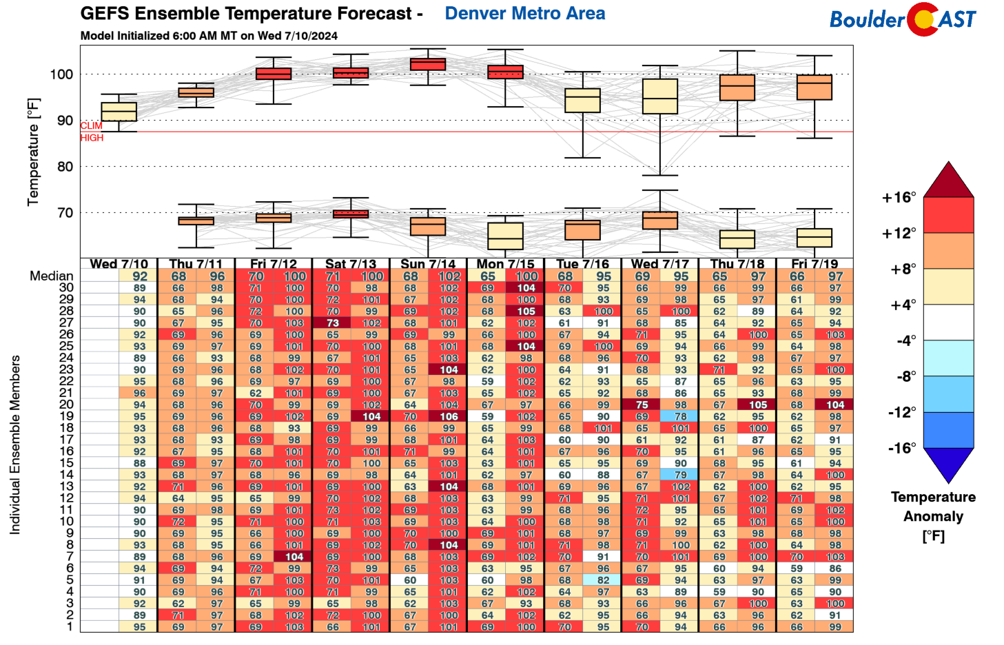
For now, the most pressing concern is the impending, prolonged and dangerous heatwave sporting the triple-digit temperatures that lie ahead. Here’s a look at the BoulderCAST forecast through Monday below.
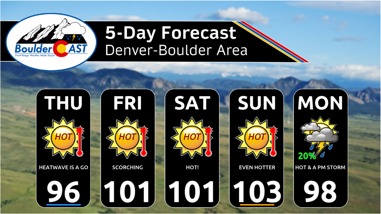
We are currently predicting a trifecta of triple-digit high temperatures on Friday, Saturday and Sunday — with Sunday looking to be the hottest outing right now. Depending on whether or not the ridge breaks down a tad sooner, we could see a small chance of rain Sunday but for now we’ll keep the forecast dry. If rain does enter the picture, that could lead to a slight reduction in temperatures during the back half of the weekend.
Our current forecast highs would only lead to one new daily record temperature being broken in Boulder on Monday July 15th. The previous record of 99°F set back in 1931 has a high chance of being toppled. Also, consecutive 100°F days hasn’t happened in Boulder since 2012 and that looks to be a somewhat safe bet this weekend. We may even line up three or four!
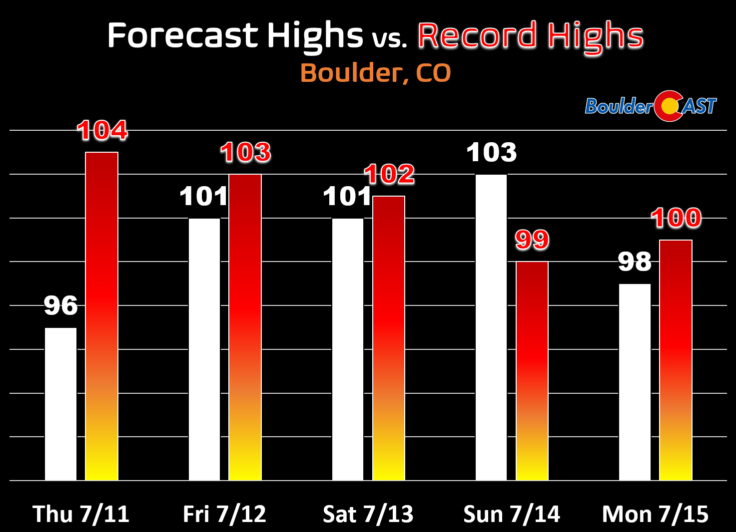
Other records that could fall this weekend include:
- All-time record high temperature in Denver (105°F, reached 5 times, last in 2018): Sunday will offer the best chance to possibly tie or break this record, though it could occur other days. Denver International Airport often gets surprisingly hotter than models are predicting.
- All-time record high temperature in Boulder (104°F reached twice in 1954): Sunday again will give us the best chance at this record, but we’re currently not expecting Boulder to get this warm.
- Longest Streak of 100°+ days in Boulder (4 days): Our current forecast calls for three in a row, but it’s possible Monday may reach 100 depending on the rain/storm cloud situation.
- Longest Streak of 100°+ days in Denver (5 days, 3 times with most recent in June 2012): Again, we’re currently not forecasting this many, but it is possible that Thursday and Monday could hit 100 at DIA
- General daily record highs in both Boulder and Denver any day: Though our current forecast does not call for additional daily record highs, we will be in the right ballpark almost every day. It’s possible that one or two additional daily record highs are broken through Monday.
A Heat Advisory has been posted for the entire Denver Metro area and northern Front Range. The advisories will be in effect Friday, Saturday and Sunday from 10AM to 8PM daily. Air Quality Alerts for ozone are also in effect and will likely remain so through Monday.
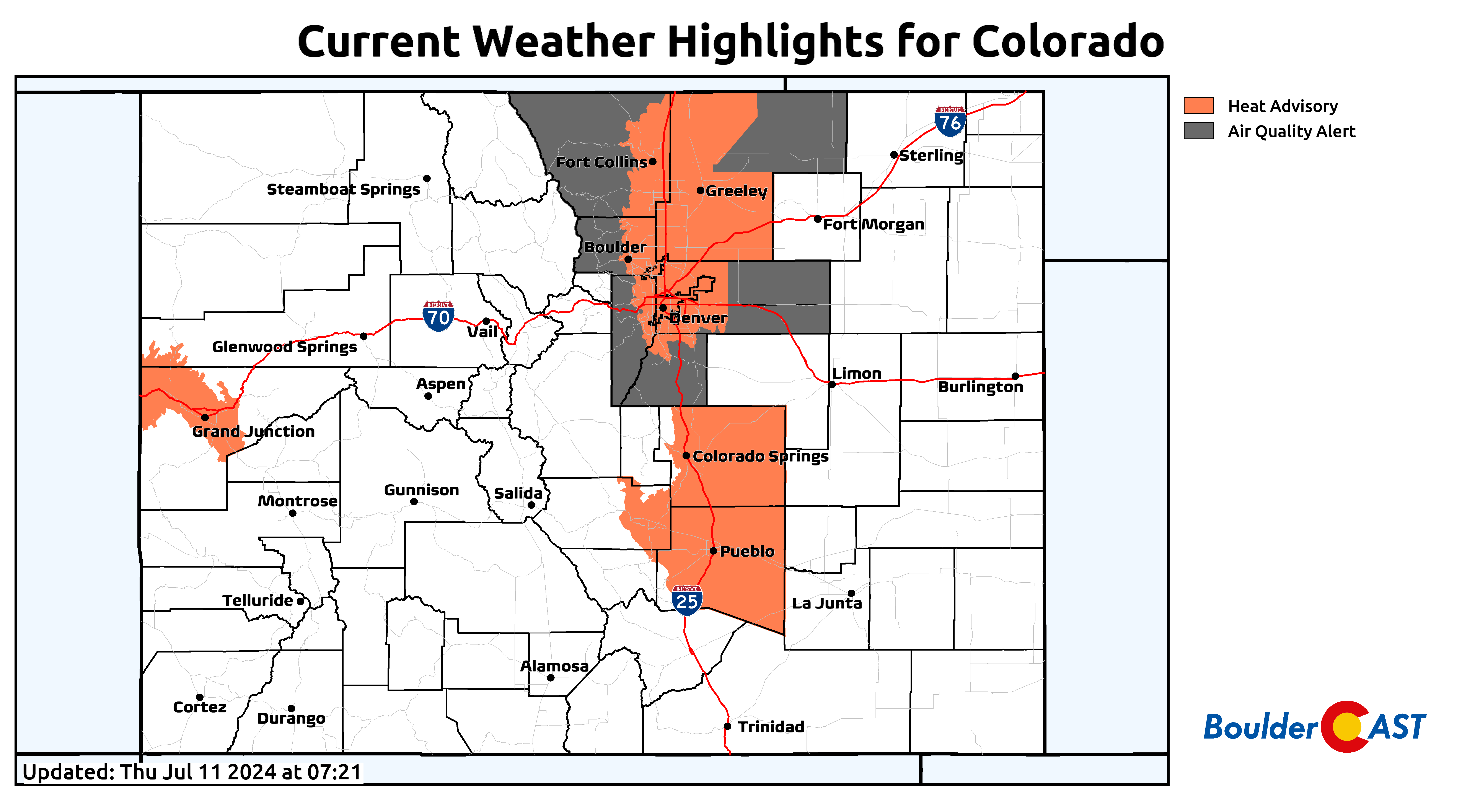
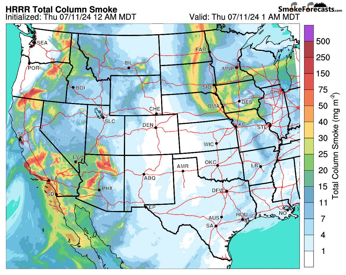
With elevated ozone overlapping the extreme heat, the next few days will be especially dangerous for sensitive groups. Furthermore, we will also see an uptick in wildfire smoke entering the region in the coming days. We’ve been pretty lucky of late dodging most of the smoke, but that’s primarily because all of the fires burning in the West were under the epic stalled ridge. With that ridge now shifting eastward and set to weaken next week, more and more smoke will work into the Front Range over time. Latest model forecasts show smoke increasing each day beginning Thursday. By Saturday and Sunday, visibility will be notably reduced in our area as thicker smoke works in, especially over the Mountains. All those tiny smoke particulates floating in the atmosphere above would bring a net cooling effect on our surface temperatures as a portion of the sun’s energy is scattered, absorbed and reflected away. Despite this, the expected smoke content is probably not high enough to substantially cut into our heatwave more than a degree or so some days.
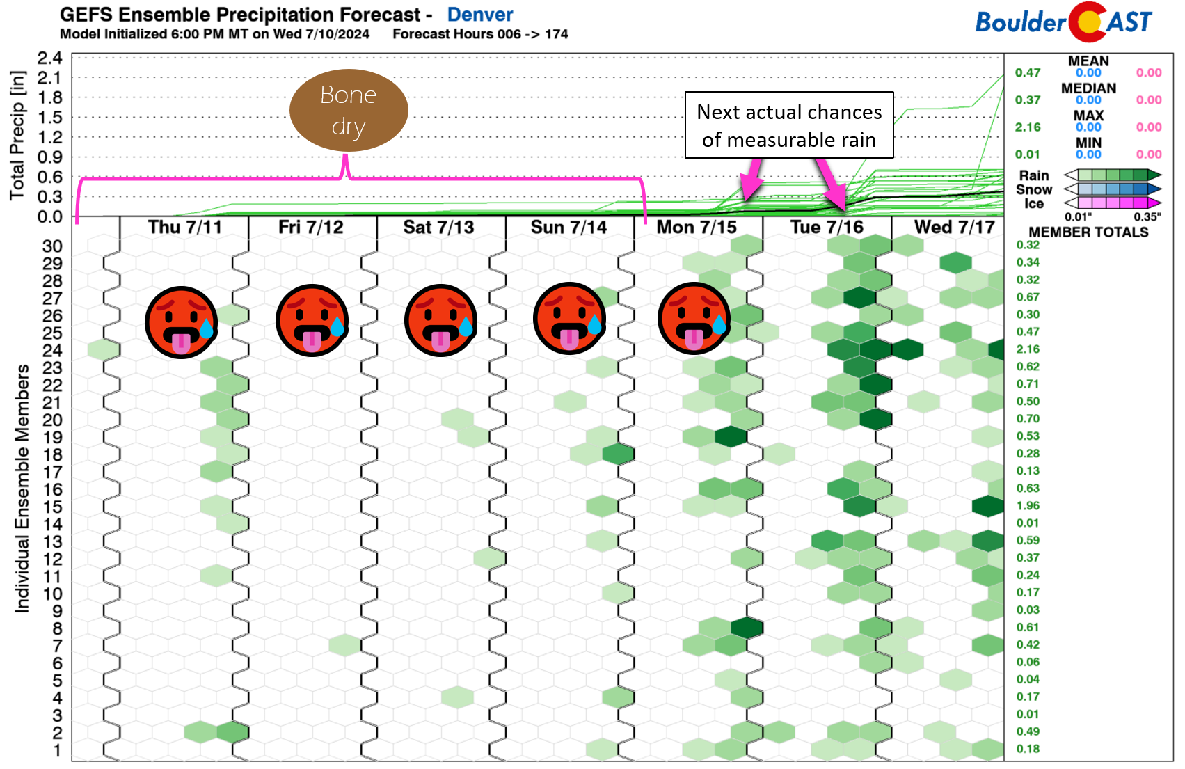
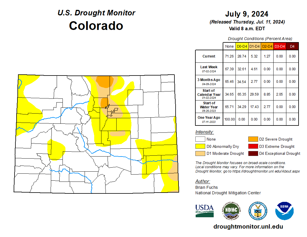
More bad news: just today portions of Boulder, Larimer and Weld Counties were upgraded (downgraded?) to Severe Drought status by the USDM, which is no surprise given the lack of rainfall the last two and a half months. This is terrible news considering there will be almost no rain for us in the next five days as the heatwave rages on. Even worse, we’ve already explained why we expect the summer monsoon to be largely absent this year from Colorado. We can’t really stress much more how troubling the situation is in the Front Range right now. It’s only a matter of time before significant (e.g. fiery) impacts start to catch up with us, but that’s a post for another day…
That’s all we have for now. Be smart this weekend and don’t push yourself too much in the extreme heat and don’t start any new wildfires. Stay cool!

Stay up to date with Colorado weather and get notified of our latest forecasts and storm updates:
We respect your privacy. You can unsubscribe at any time.

Go Premium, get all the perks.
Daily Forecast Updates
Get our daily forecast discussion every morning delivered to your inbox.
All Our Model Data
Access to all our Colorado-centric high-resolution weather model graphics. Seriously — every one!
Ski & Hiking Forecasts
6-day forecasts for all the Colorado ski resorts, plus more than 120 hiking trails, including every 14er.
Smoke Forecasts
Wildfire smoke concentration predictions up to 72 hours into the future.
Exclusive Content
Weekend outlooks every Thursday, bonus storm updates, historical data and much more!
No Advertisements
Enjoy ad-free viewing on the entire site.
Enjoy our content? Give it a share!


You must be logged in to post a comment.