More snow is on the way to the Front Range for midweek, but it comes with strong winds beforehand. An Arctic front will slam the area on Wednesday bringing a rapid drop in temperatures alongside some moderate to heavy bands of snow across the entire area. We discuss how strong the winds will be, when the frigid airmass and snow will arrive, and how much snow will pile up.
Premium Storm Update (1/5/22 7:00AM): We do a final check on the latest model runs and confirm that the rift in outcomes still exists. We give our final thoughts on the storm and how the model disagreement plays into forecast snow amounts . READ HERE.
At a Glance:
- Downslope winds will impact the entire area on Tuesday with gusts up to 80MPH in the Foothills, up to 65 MPH in Boulder and up to 50 MPH in Denver
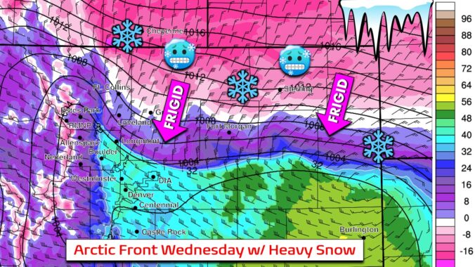
- A strong Arctic front will slam the area during the day Wednesday dropping temperatures from the 40’s into the single digits quickly
- Pockets of heavy snow will follow the front Wednesday afternoon/evening with lighter snow later on — likely impacts on Wed PM commute
- The Mountains will get hammered again with another 1 to 2 feet along and north of Interstate 70
- Snow accumulations across the lower elevations are somewhat uncertain right now, but we’re thinking 1-3″ in Denver and 3-6″ in Boulder
We discuss Boulder and Denver weather every single day on BoulderCAST Premium. Sign up today to get access to our daily forecast discussions every morning, complete six-day skiing and hiking forecasts powered by machine learning, access to all our Front Range specific weather models, additional storm updates and much more!

Strong winds on Tuesday
With a potent northwesterly jet streak overhead and a favorable setup for mountain wave development, strong winds will gust across the Front Range during the day Tuesday. We talked more about the specifics of this wind event in our Premium forecast discussion this morning. However, the high-level summary is that winds will increase during the morning, maximize around midday or early afternoon Tuesday and then wane after sunset. Peak gusts will be around 85 MPH in the Foothills, 70 MPH in Boulder, and 55 MPH in most of the Denver area. Certainly not as strong as the wind event last week that spread the Marshall Fire, but still a significant event. Fire danger is thankfully very low due to the recent snowfall still blanketing the ground just about everywhere.
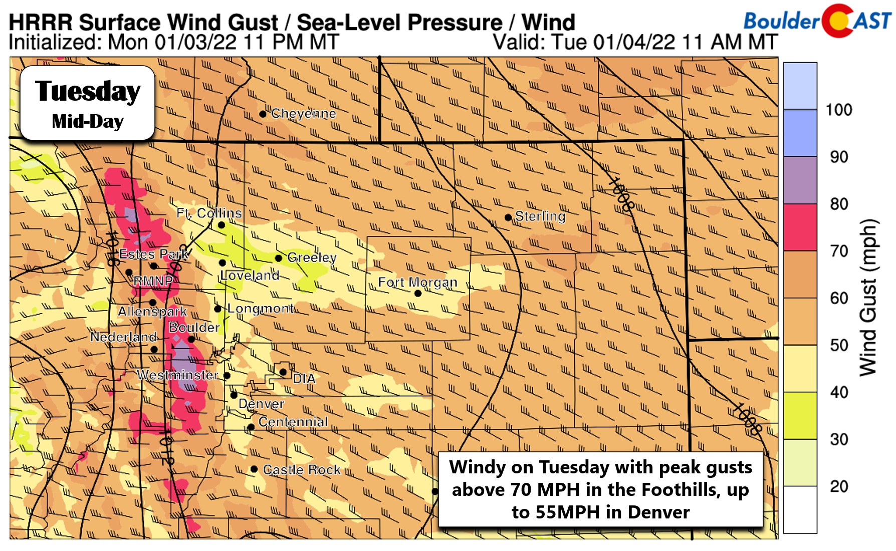
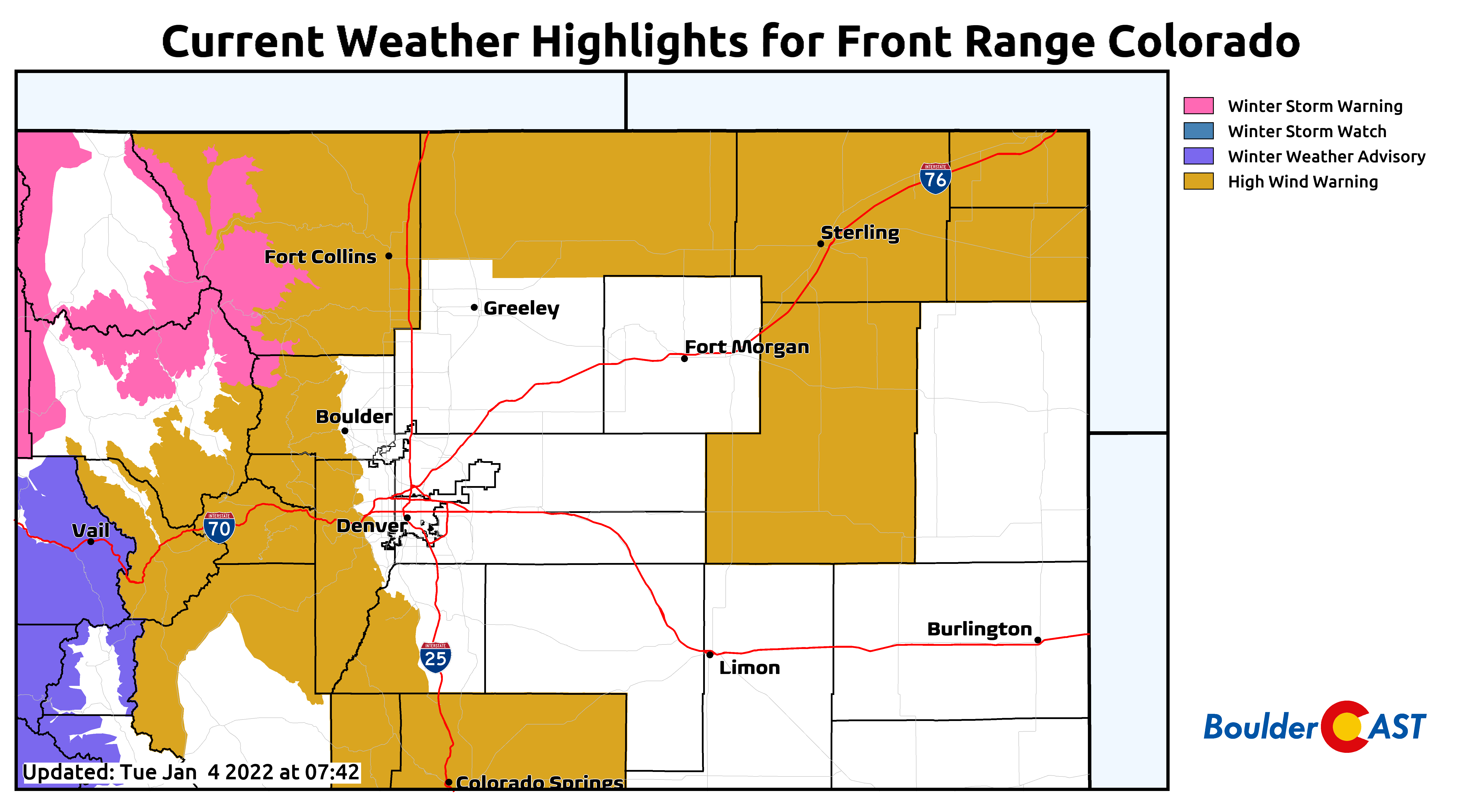
High Wind Warnings are in effect for the Mountains and Foothills through 5PM Tuesday, as well as areas along the Wyoming border. Winds could be nasty along Highway 93 again between Boulder and Golden, so be careful in any high-profile vehicles.
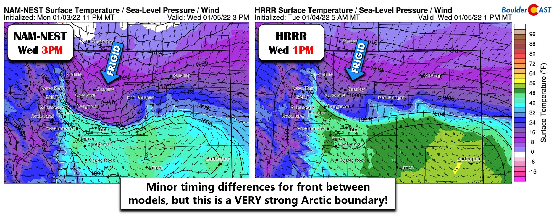
Bitter cold and heavy snow bands Wednesday
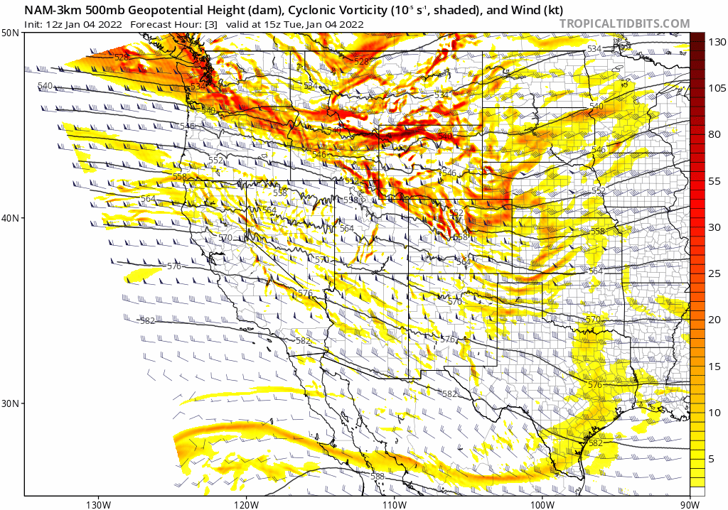
Tuesday’s wind is just the precursor to the fast-moving wintry storm system headed this way from the northwest which will only brush northern Colorado Wednesday into Wednesday night. As noted in the 500mb vorticity animation below, there’s not really much to this storm with barely a dip in the height lines. Thus, there won’t be much large-scale lift as it moves through to facilitate widespread snowfall.
However, this glancing blow will usher a VERY strong cold front through the Front Range on Wednesday with temperatures dropping like a rock. This front is the most intense we have seen this season by a long shot. High-resolution models currently have a few hours of variation on the timing into Denver, but these type of Arctic boundaries tend to come in faster than models expect. For now, plan on this front arriving sometime in the late morning to early afternoon timeframe. Before the front, gusty west winds will be around with temperatures in the 40’s. After the front, temperatures tumble rapidly into the teens and single digits with winds flipping around to northeasterly.
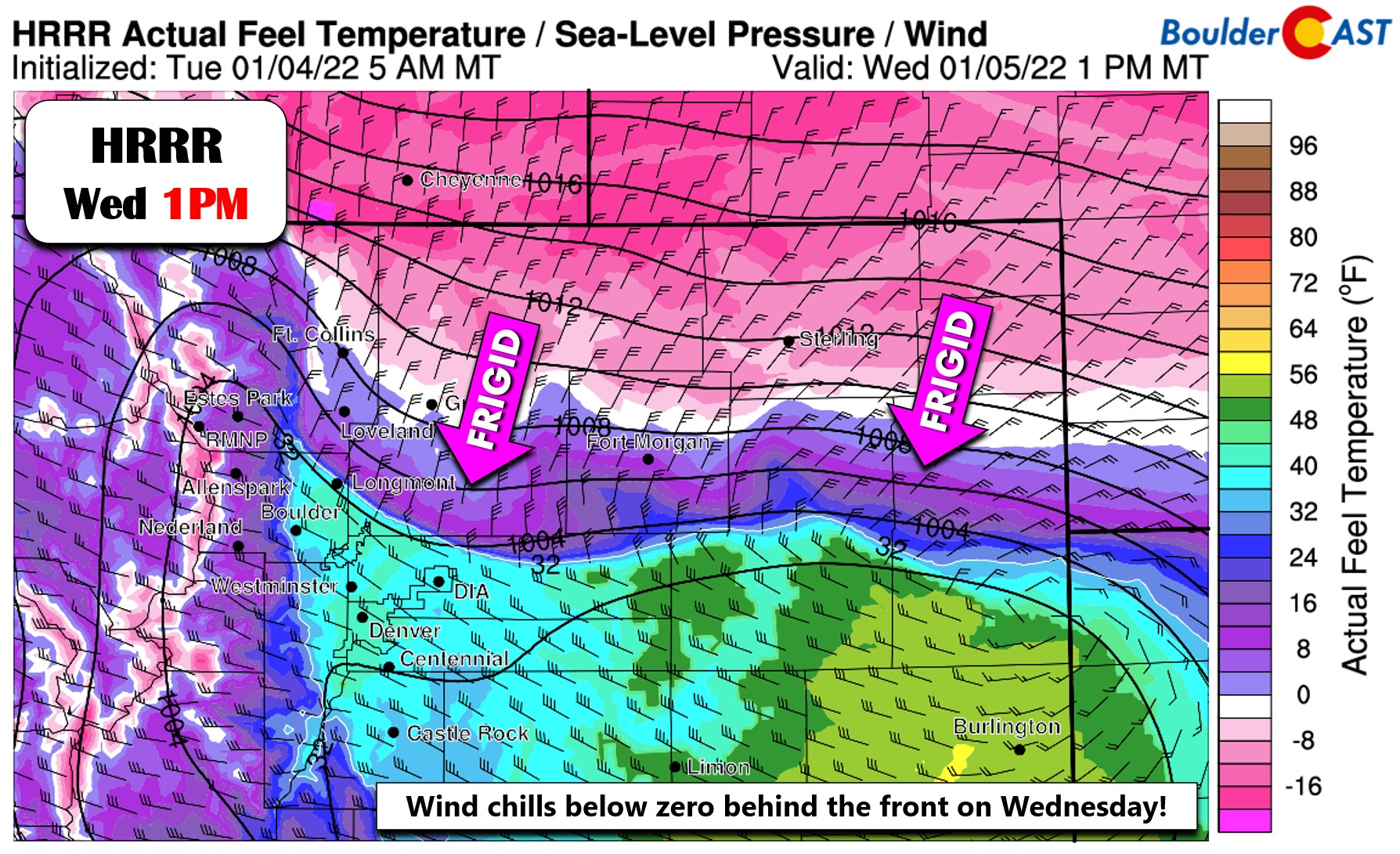
Even more shocking than the drastic drop in temperature will be the wind chills behind the front. They plummet almost immediately below zero and even close to 20 below zero further northeast.
At the same time the front is plowing through, a potent jet streak will be oriented in such a way that puts the Denver Metro area in the favorable left-exit region for banded snowfall.
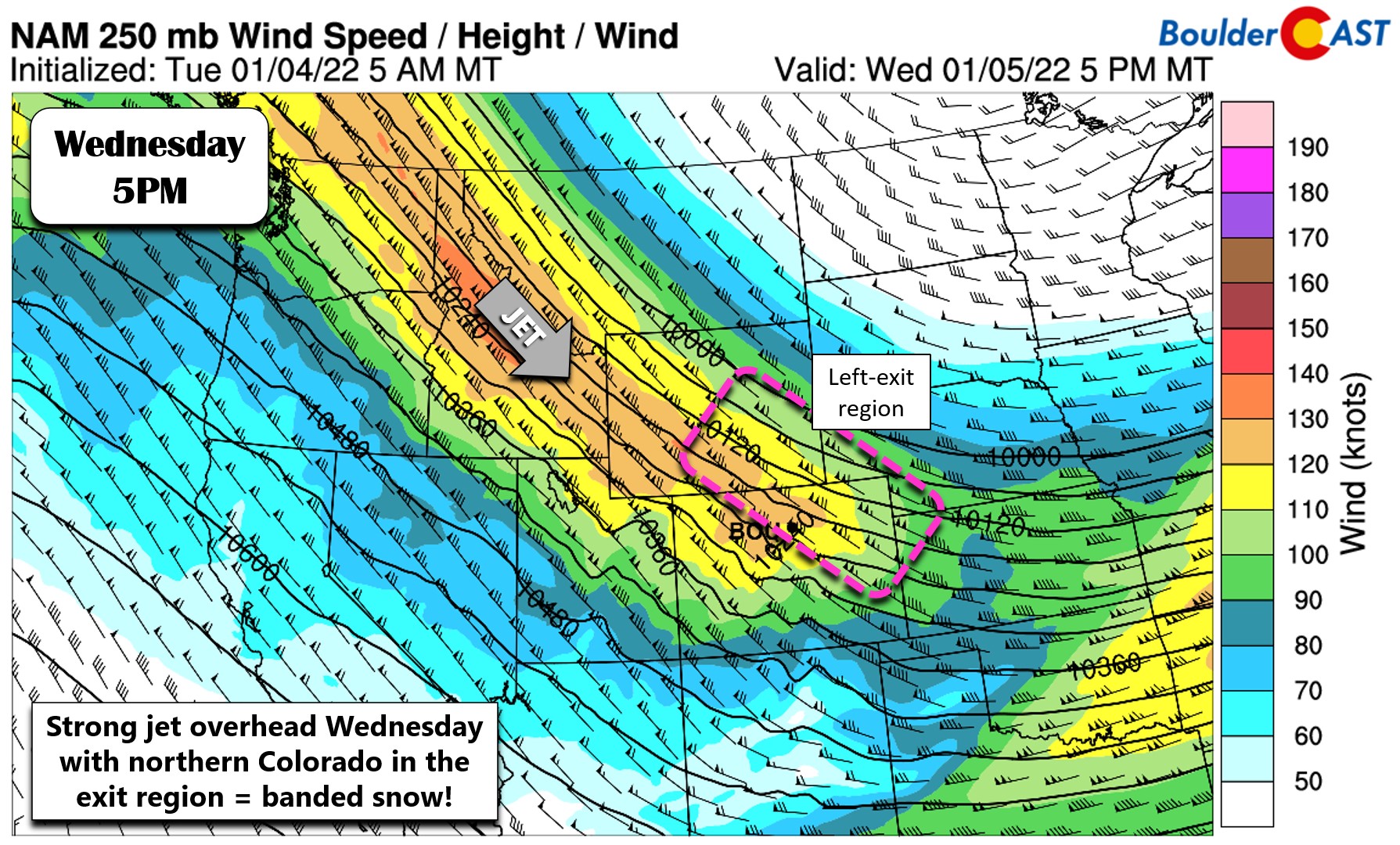
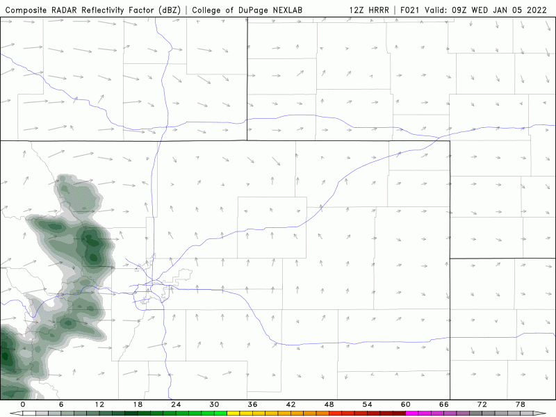
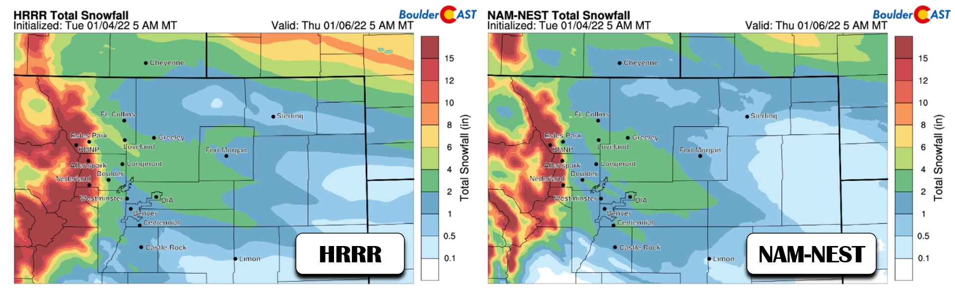
Between the strong frontal forcing and jet streak forcing, we are quite confident that banded snow will develop over northern Colorado and sag southward across the entire Denver Metro area during the afternoon into the evening hours on Wednesday. Below is a simulated radar animation from the HRRR model. These bands will produce bursts of moderate to heavy snow and will hit during the afternoon into early evening which, depending on the exact timing, could put a wrench into the Wednesday evening commute.
The jet and frontal forcing will only be around for a few short hours, after which very shallow and bitter cold upslope may keep very light snow going into the evening hours, fully ending after midnight.
This system will also work its orographic magic along and west of the Divide where a dumping of powder is expected beginning Tuesday afternoon and continuing into Wednesday night. The northern Mountains will be favored for 12 to 24″ from this storm (heaviest during the morning and afternoon Wednesday), but the central Mountains including the I-70 ski resorts, should also do well from this event — we’re thinking 10-15″. The west-northwesterly direction to the fast winds aloft will also favor the higher Foothills above 8500 feet elevation which should see anywhere from 4 to 12″ through Wednesday night from spillover off the Continental Divide.
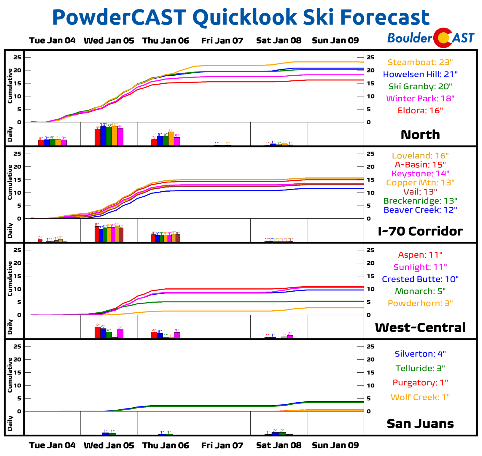
Across the lower elevations, due to the brevity of the heavier bands, we’re expecting lighter accumulations of a few inches. It will be fluffy snow though considering the bitter cold temperatures behind the front. Our two favorite high resolution models show generally 1-5″ across the Denver area.
The global models are a little more bullish on snow amounts overall. The Euro, for example, dumps close to a foot of snow in Boulder from this event! The GFS is closer to 6″. Usually the global models would struggle to even resolve this feature at all, so we do think there is some credence to these higher projected totals.
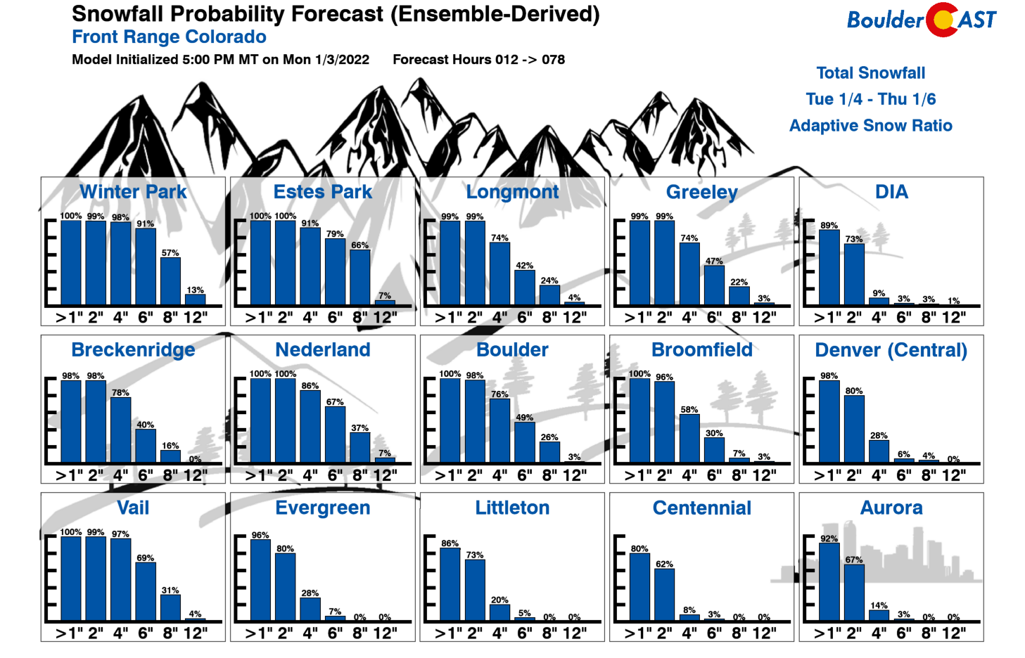
Our ensemble-derived snowfall probabilities definitely lean towards the higher amounts, with about a 50% chance of 6″ in Boulder, but only a 28% chance of 4″ in downtown Denver.
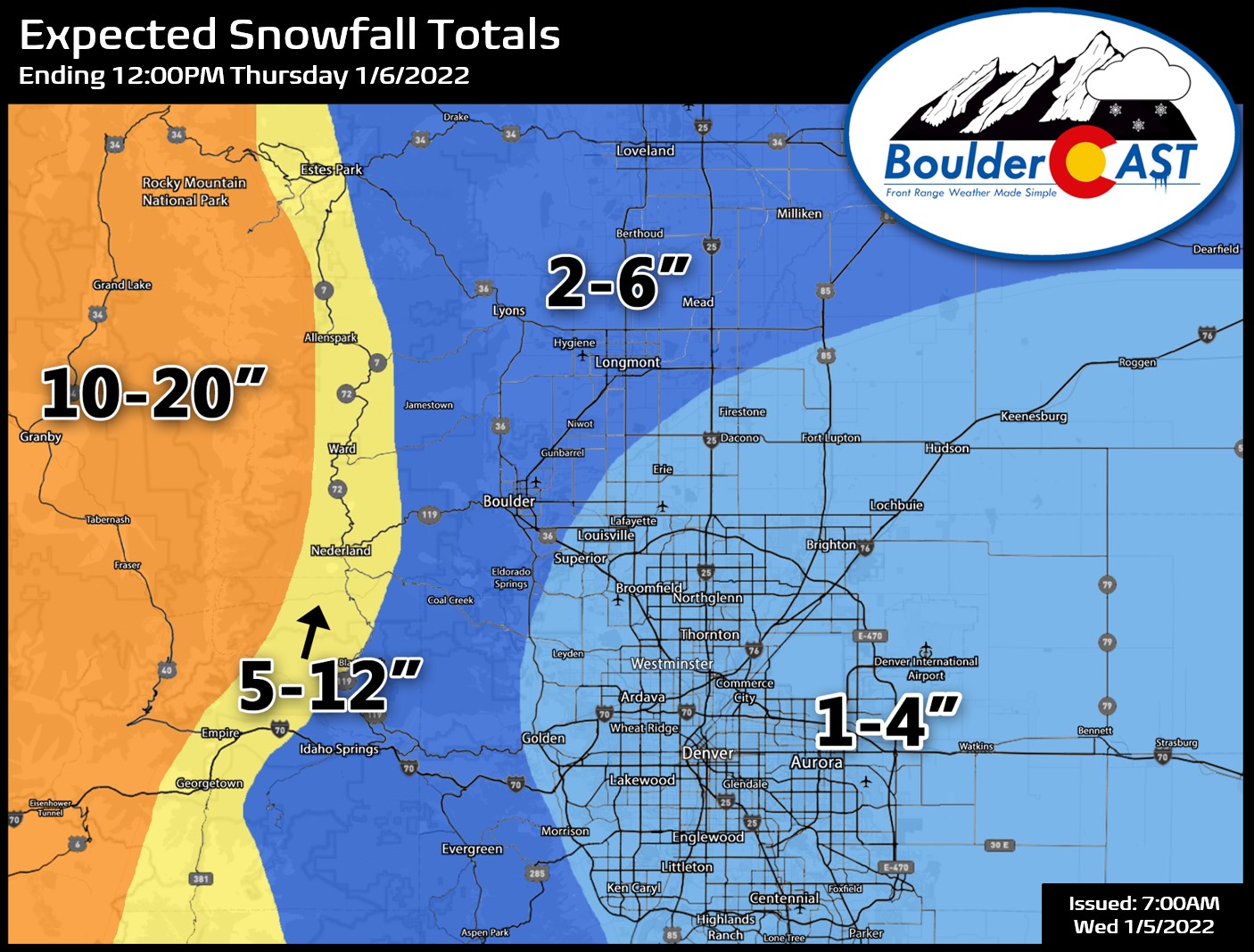
We must say that uncertainty is still quite high on amounts across the lower elevations right now. We’re not sure exactly how hot these bands will come into our area and how long they will persist exactly. With snowfall rates of 1 to 2″ per hour, slight differences in timing and location will mean big shifts in snowfall amounts. Our latest thinking on this event has been translated into our snowfall forecast map shown below covering all snowfall through Wednesday night. After the snow, temperatures fall close to zero degrees by sunrise Thursday and stay below freezing during the day. We should warm up quickly Friday back even into the 50’s.
There’s a decent chance we will need to update our snow map later tonight or early Wednesday morning depending on how things are looking (updated already!). We may even do so just to narrow down the ranges a little since they are broad at the moment. For now, stay tuned and subscribed:
Get BoulderCAST in your inbox:
Help support our team of Front Range weather bloggers by joining BoulderCAST Premium. We talk Boulder and Denver weather every single day. Sign up now to get access to our daily forecast discussions each morning, complete six-day skiing and hiking forecasts powered by machine learning, first-class access to all our Colorado-centric high-resolution weather graphics, bonus storm updates and much more! Or not, we just appreciate your readership!
Enjoy our content? Give it a share!


You must be logged in to post a comment.