The week will end with a bang as snow is headed to the Denver Metro area on Friday thanks to a quick-moving storm system diving across the state. A front will pass through early Friday morning bringing colder temperatures for the day with snow developing late in the afternoon into evening. This event will be headlined by the risk of heavy jet-forced snow bands which could wreak havoc on the evening commute. Let’s take a look at the atmospheric setup, timing of the first flakes and heaviest snow, and our snowfall forecast map.
At a Glance:
- A cold front will blow through during the early morning hours on Friday bringing northerly winds and a significant cool down
- It will take a while, but snow is expected to develop during the afternoon and linger through the evening
- Bursts of heavy snow possible in and around the evening commute on Friday creating troublesome travel
- Generally 1 to 5″ of snow expected, though locally higher totals are possible in the heavier bands
- Dry and warmer weather then takes over for the weekend into next week as a ridge keeps us sunny
We discuss Boulder and Denver weather every single day on BoulderCAST Premium. Sign up today to get access to our daily forecast discussions every morning, complete six-day skiing and hiking forecasts powered by machine learning, access to all our Front Range specific weather models, additional storm updates and much more!

A
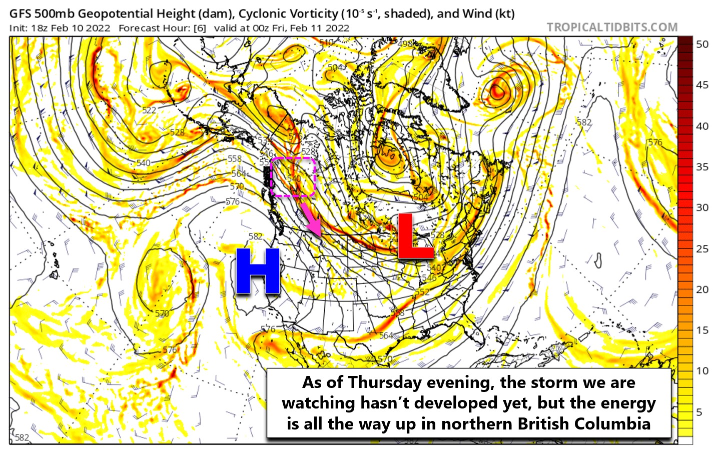
s discussed in our Monday outlook, this week has already been plagued by several quick-hitting but ultimately weak storm systems which have dropped straight south out of Canada into Colorado. So far they have not amounted to much for us — just a few periods of slightly cooler temperatures and a couple spotty snowflakes Wednesday night. This active pattern rolls on with another system diving into Colorado on Friday. This is the one we’ve been most hopeful would produce some Front Range snow throughout the week and it looks to be well on the way to delivering just that.
The storm system in question actually hasn’t even formed yet. However, the atmospheric energy that will eventually morph into our snow-maker is located all the way up in northern British Columbia as of writing Wednesday evening. This area is highlighted in the pink box below.
While it may not look like much yet, we know what’s coming thanks to the magic of numerical weather prediction models! The animation below shows the trough forming and moving across Colorado Friday into Friday night from the north.
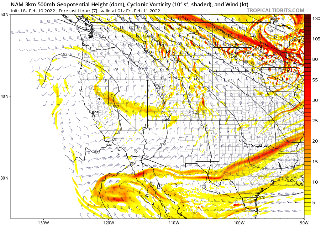
Much like the other systems this week, the incoming storm will be absolutely screaming southward through our state, not leaving too much of a window for snow in the process — just about 5 to 8 hours at most. However, we’ve got more moisture to work with this time around and there are some interesting dynamics in play which will lend to the potential for pockets of heavier snow .
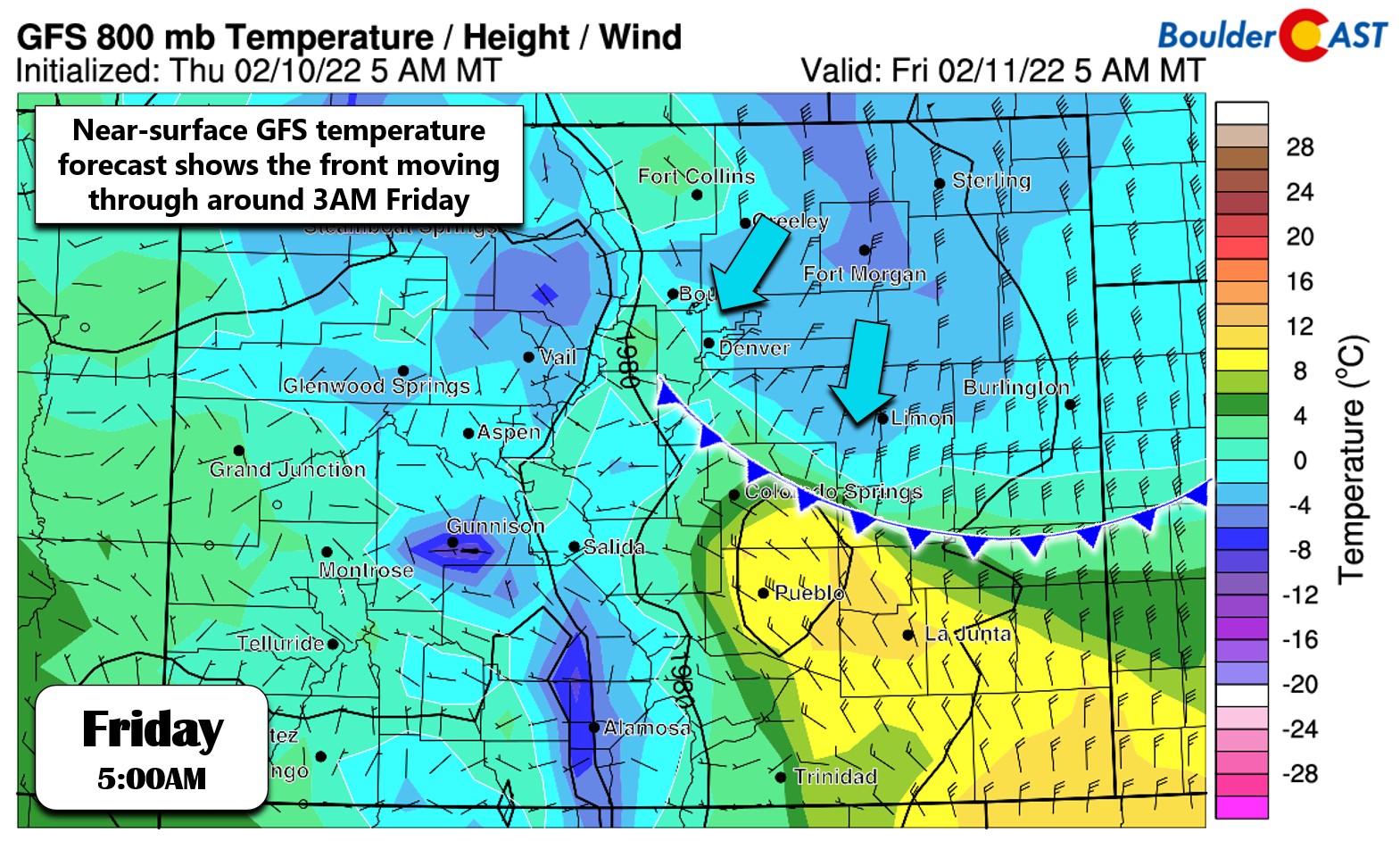
Let’s start off with the cold front. That will arrive early Friday morning bringing mostly northerly winds to the region. In the immediate Denver Metro area, winds will take on more of a northeasterly upslope component (see below). As a result of this upslope, we may see some very light stratiform snow or flurries break out through the morning hours as the lower atmosphere begins to moisten up. This won’t accumulate.
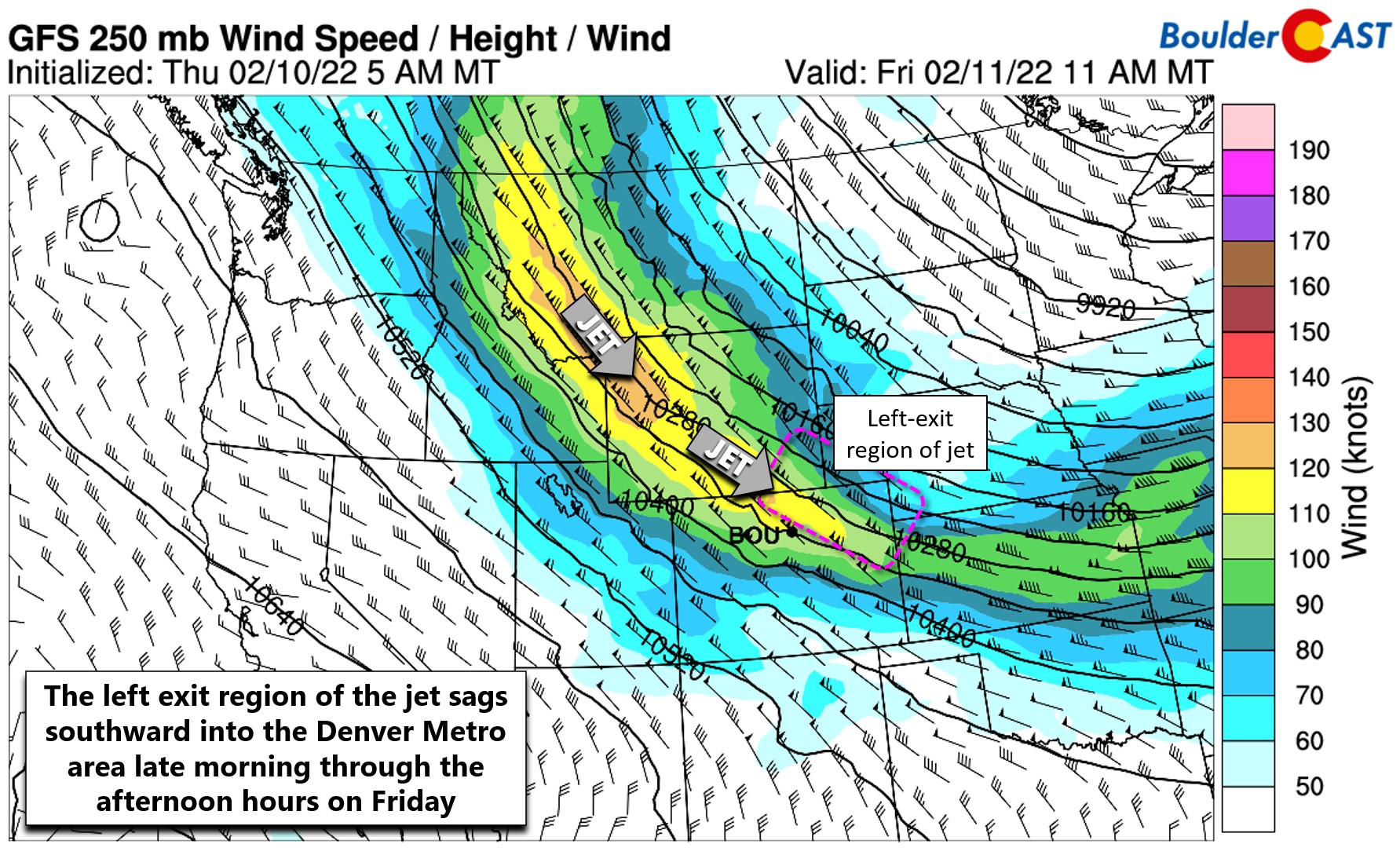
However, this cold front alone isn’t enough to generate much snow across our area. We’ll have to wait until afternoon for the jet stream to arrive and up the ante further. We’re seeing excellent model support now that the Denver Metro area will end up in the left-exit region of a jet streak sagging southward during the day Friday (shown below). It’s quite difficult to predict these type of fine-scale jet features many days in advance, but we’ve had a good handle on this setup for a while now. Thus, we’re fairly confident that jet-forced snow bands will develop across the Front Range later on Friday.
Furthermore, lapse rates turn marginally unstable by evening which increases our confidence for heavy snow, even if the best fetch of instability in the atmosphere remains beneath the dendritic snow growth zone. The lack of strong lift lining up with the snow growth layer is one reason (among many) that we dont expect significant snow potential from this system. A few other reasons include the brevity of the event and the relatively warm temperatures at ground-level early on (middle 30’s falling into the 20’s).
The jet will arrive first to the far northern Front Range by late morning, reaching Boulder around early to mid afternoon and then into Denver by late afternoon. As this happens, banded snowfall will sag southward and overtake the area. Again, this isn’t an ideal setup for winter weather exactly, though this could very well be the most jet-driven snow event we’ve seen so far this season. The HRRR model-simulated radar animation below shows the snow bands sagging southward through the day. In particular, this model is indicating a pretty nasty snow band parked over Boulder and Denver in the evening — maybe even directly aligning with rush hour!

HRRR model-simulated radar animation for Friday showing the heavy snow bands possible across the area
As the trough axis rapidly races south across Denver during the mid to late evening, snow will abruptly come to an end. Things will dry out quicker than that northeast of Denver.
SNOWFALL AMOUNTS
Snowfall amounts for this event have been creeping up through the week as more and more models have gotten on board with things. It now looks like a safe bet than most of us will see between 0.1 and 0.4″ of moisture on Friday. The GFS precipitation forecast is shown below.
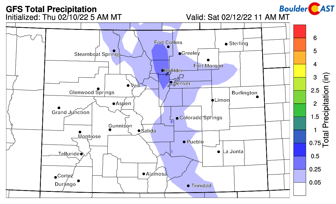
GFS total precipitation forecast through Friday night. Not a huge event for us, but a little snow for everyone!
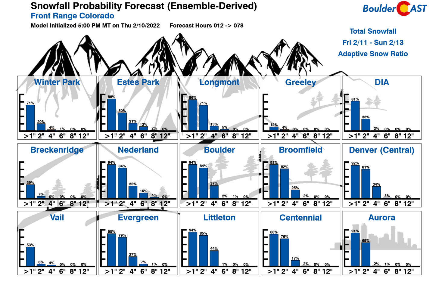
Given the warmer temperatures, snow ratios will be lower than we’ve seen in any in the slew of January snow events — on the order of 14:1 this time. Simple math alone puts potential snow totals in the 1-5″ range for the region. This matches with the latest snowfall forecasts from the operational Euro and GFS models:
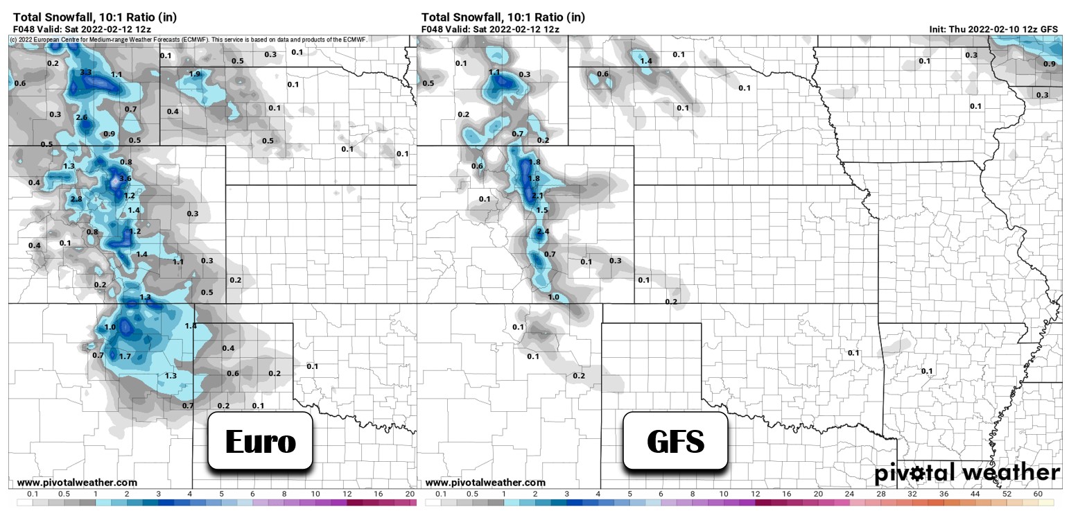
We feel that our latest Snowfall Probabilities capture the range of potential outcomes quite well. Basically a good chance most areas pick up at least 2″, but minor chances for exceeding 4″ as well.
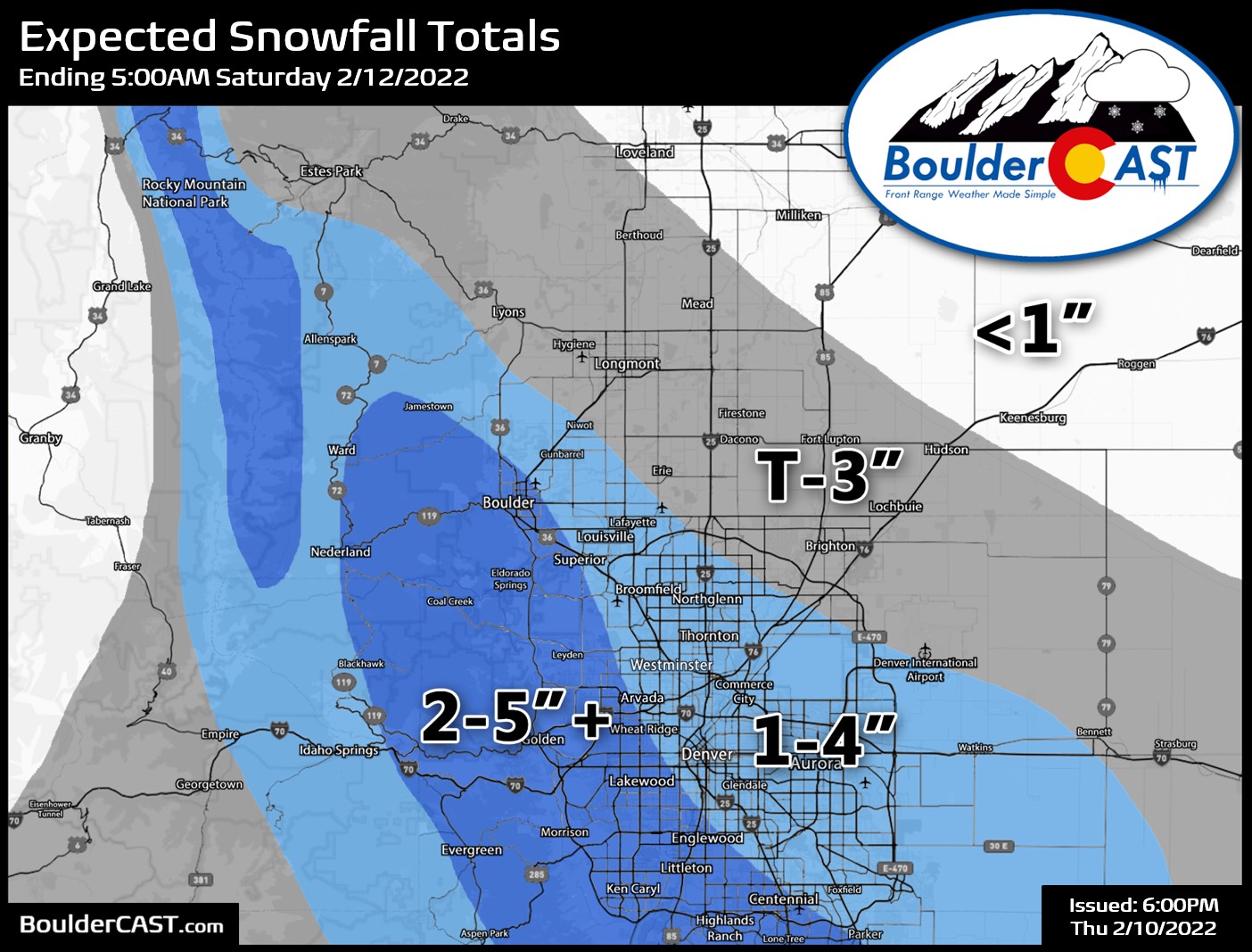
Our snowfall forecast map for the event is shown below. The very nature of jet-forced snow bands should lend to fairly variable totals across the area. Locally higher amounts are certainly possible with this event, mainly in the locations that end up stuck under a band of heavy snow for a couple hours.
TRAVEL IMPACTS
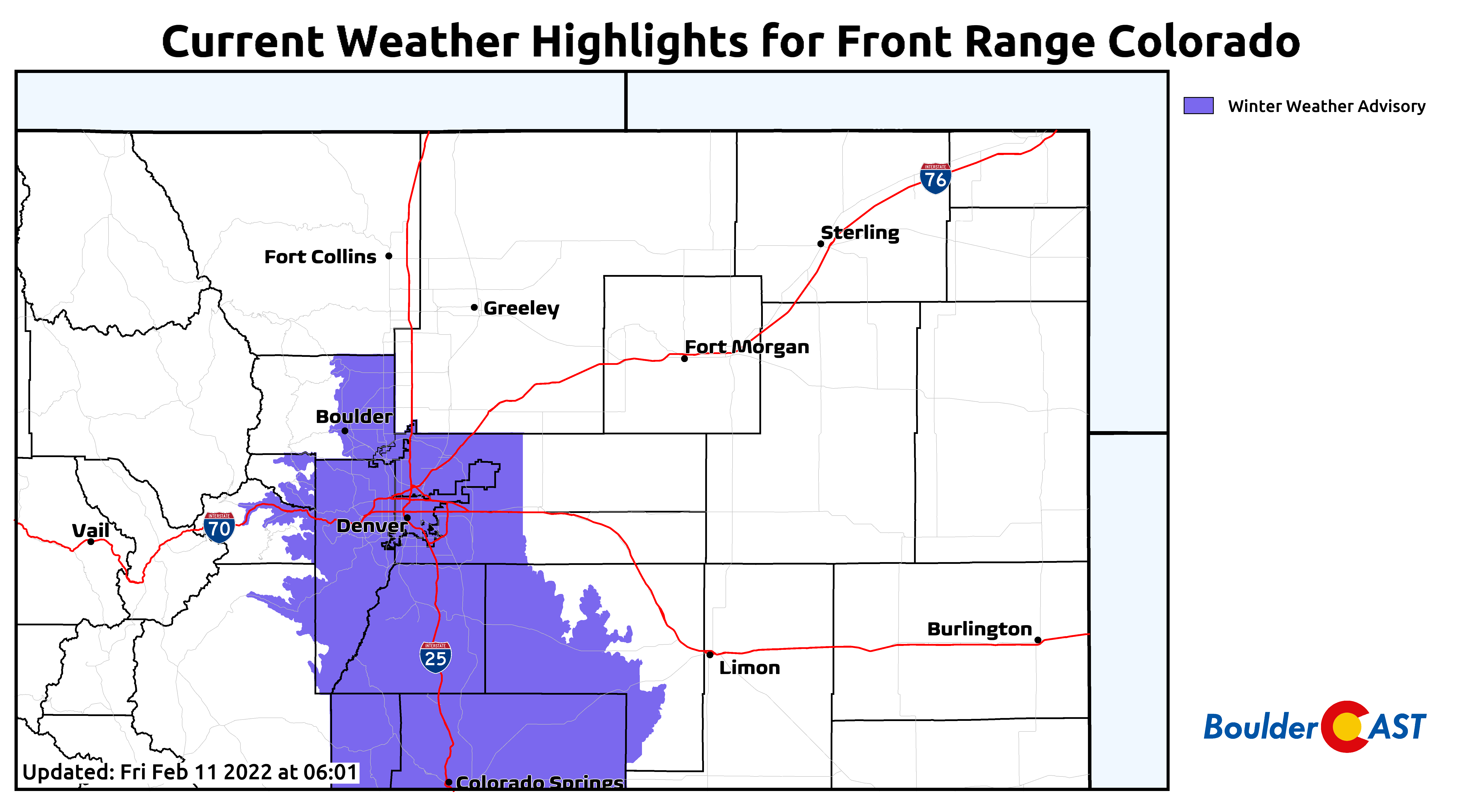
With snow beginning in the afternoon hours and ramping up into the evening, there is a strong potential for Friday’s evening commute to be impacted especially in those areas most slammed by heavier snow bands. We’re not expecting anything too bad due to the warmer road temperatures, but don’t be surprised to see slushy or snowy conditions for the ride home on Friday or if you are headed out and about in the evening. As of writing, the National Weather Service has yet to issue any winter weather highlights for the Front Range. However, it seems possible if not likely that something will get posted considering the evening commute impacts alone. We shall see! (Update: Advisory has been posted)
After this round of snow, we dry out and warm up heading through the weekend into next week as a broad high pressure center passes west to east across the Rockies. We may even be able to string together several 60-degree days here soon!
We may put out an updated snowfall forecast map tomorrow if things look drastically different or need revised. Stay tuned and stay subscribed…
Get BoulderCAST updates delivered to your inbox:
Help support our team of Front Range weather bloggers by joining BoulderCAST Premium. We talk Boulder and Denver weather every single day. Sign up now to get access to our daily forecast discussions each morning, complete six-day skiing and hiking forecasts powered by machine learning, first-class access to all our Colorado-centric high-resolution weather graphics, bonus storm updates and much more! Or not, we just appreciate your readership!
Enjoy our content? Give it a share!


You must be logged in to post a comment.