After the surprising minor wallop of snow earlier this week and a brief reprieve on Wednesday, things turn wintry again quickly Thursday into Friday as an Arctic cold front blasts across the Front Range. Shallow but prolonged upslope will produce a period of light, fluffy snow accompanied by bitter cold temperatures. The area in and around Boulder is most favored during this event. In this winter weather update, we discuss the timing of when snow starts and stops, how much snow to expect, which commutes will be impacted most, and just how cold it will get.
Premium Storm Update (11/17/22 7:00AM): Overnight model runs have stuck to their guns and forecast confidence remains high regarding the incoming fluffy snow that will develop this morning and continue roughly 24 hours into early Friday! We provide a brief update on the timing of the snow, check in on the all the overnight model runs, and discuss a few changes we’re making to our snowfall forecast amounts — hint: they are going up a tad! READ HERE
At a Glance:
- Wednesday will be quiet and partly sunny as Colorado resides between weather systems
- An Arctic cold front arrives early Thursday morning with tumbling temperatures expected through the day — 20’s and dropping!
- Shallow upslope behind this Arctic front will force light snowfall for an extended period — beginning Thursday morning and continuing into Friday morning
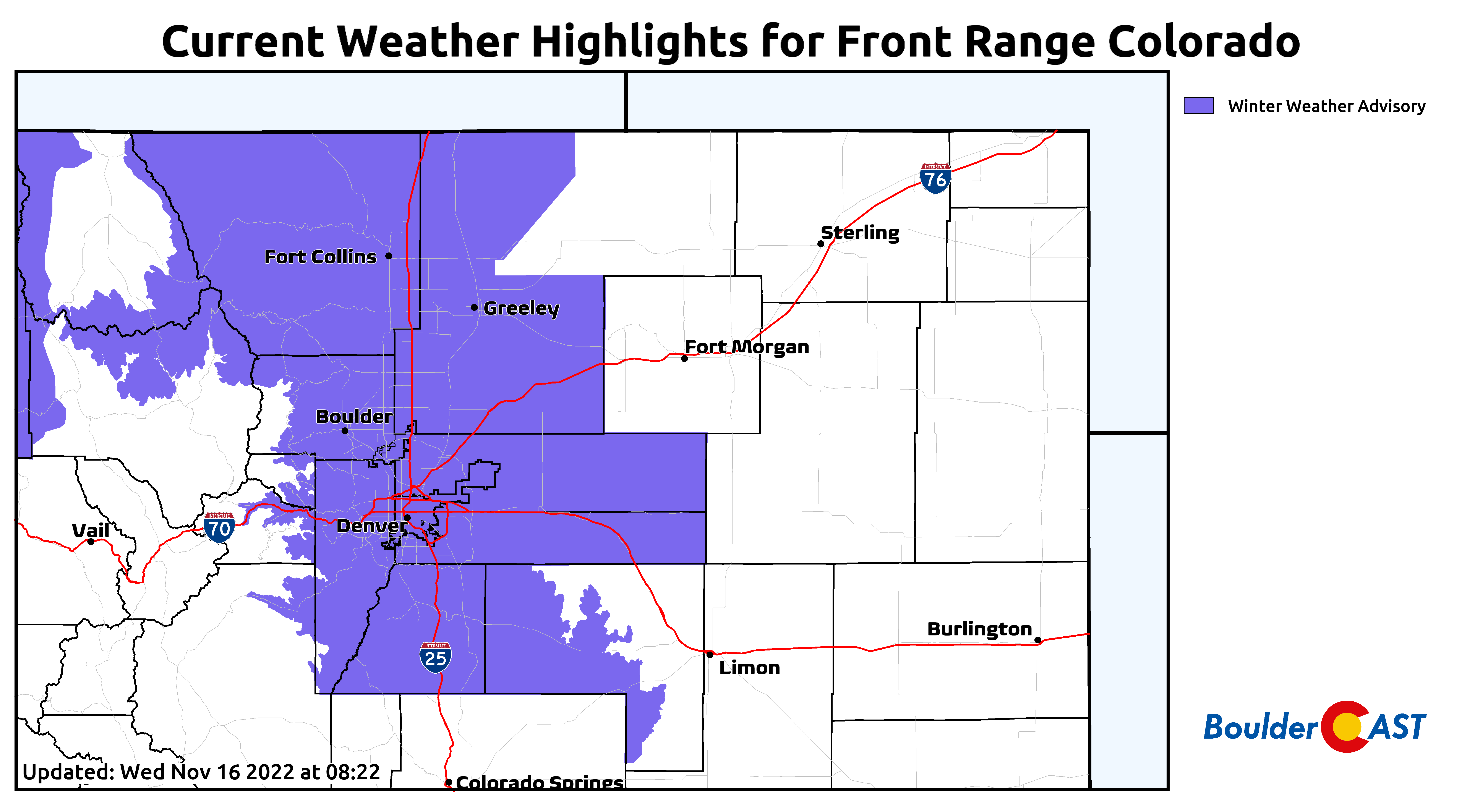
- Due to the shallowness of the upslope, areas in and along lower Foothills of Boulder and Larimer Counties will see the most snow — 6 to 11″
- The Denver area and the higher Foothills will see less snow — 2 to 7″
- Temperatures struggle to leave the teens on Friday and remain entirely below freezing until Saturday afternoon
Be prepared for the winter ahead!
We discuss Boulder and Denver weather every single day on BoulderCAST Premium. Sign up today to get access to our daily forecast discussions every morning, complete six-day skiing and hiking forecasts powered by machine learning, access to all our Front Range specific weather models (including smoke forecasts), additional storm updates and much more!

Many hours of light snow & sub-freezing temperatures ahead
Wednesday will be a decent day as Colorado resides ever-so-briefly between shortwave wintry systems. The one to watch for Thursday is dropping south out of Canada and has Arctic air on its backside. This is just one of many disturbances embedded in the northwest flow across the center of the country right now. Another one already to our south produced the booming snow totals Tuesday morning.
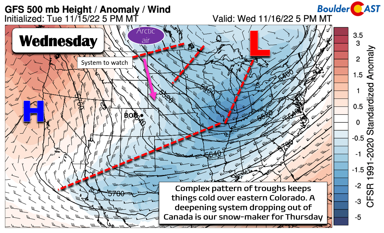
While we won’t be warming up that much Wednesday, it will be the warmest day of the week as temperatures rise in to the lower 40s by afternoon under partly cloudy skies.

The bottom falls out Thursday, though, as a doozy of an Arctic front is expected to move through in the early morning hours across the Denver area. This timing has been shifting earlier over the last few days and means temperatures will not get above freezing at all on Thursday — a perfect situation to help cool ground and road temperatures to prime them for accumulating snow…
The broader pattern across North America right now has a highly-amplified ridge of high pressure over Alaska, a pattern that is notorious for producing bitter cold weather across eastern Colorado. The big fetch of northerly flow east of this ridge in Alaska effectively “slingshots” the dense Arctic airmass southward into the United States. This is exactly the setup unfolding in the days ahead.
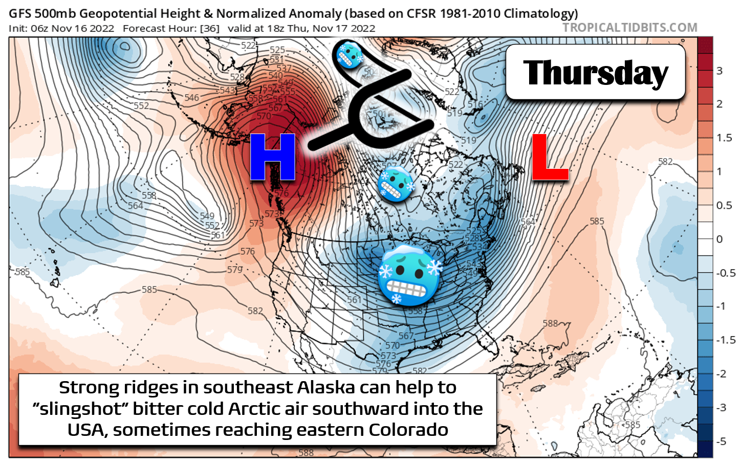
Similarly, this setup will set the table for an interesting snow event overall — one that will be forced mostly by a massive 1,050 millibar Arctic high dropping through Montana. The bitter cold, clockwise flow around this high pressure system will drive upslope into the Front Range for roughly a 24-hour period beginning early Thursday and continuing into early Friday.

Below is a closer look at forecast of the wind fields around this high pressure for Thursday night. Note how all the winds across eastern Colorado are blowing from the east which is upslope for everyone east of the Continental Divide, including the Denver Metro area.
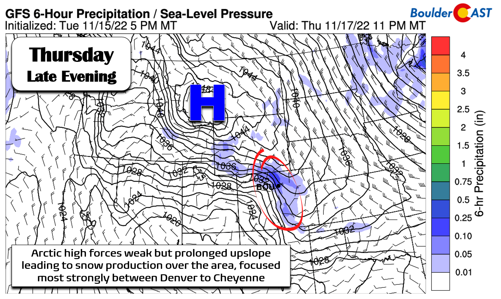
The long-lasting period of easterly winds will keep light snowfall going for upslope-favored areas for ~24 hours straight. The best upslope will be across Boulder and Larimer Counties which tend to benefit most from this type of setup due to the orientation of the terrain there. This is where we are expecting the biggest dump of snowfall from this event. Most models have 0.25 to 0.5″ of precipitation in and near the Foothills of this area, including in Boulder and Fort Collins, with lesser amounts south and east including around Denver.

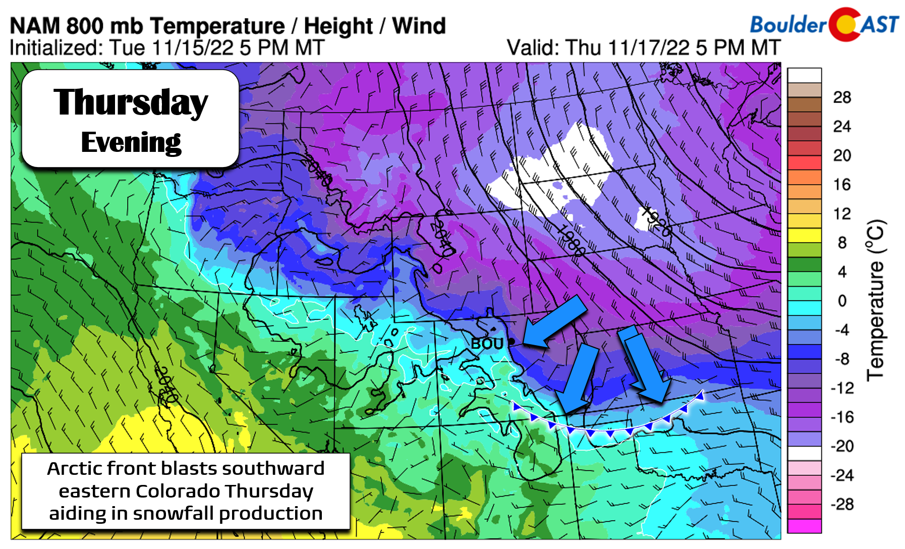
One key consideration is just how shallow the upslope will be Thursday into Friday — a result of that cold, dense Arctic airmass hugging the ground. If we take a look at the temperature and wind forecast for roughly 6500 feet elevation (the 800mb level) Thursday evening, we spy beautiful healthy upslope (see below). Almost due easterly winds will be banking up against the terrain just west of the Metro area — a perfect setup to help squeeze moisture out of the relatively dry Arctic airmass.
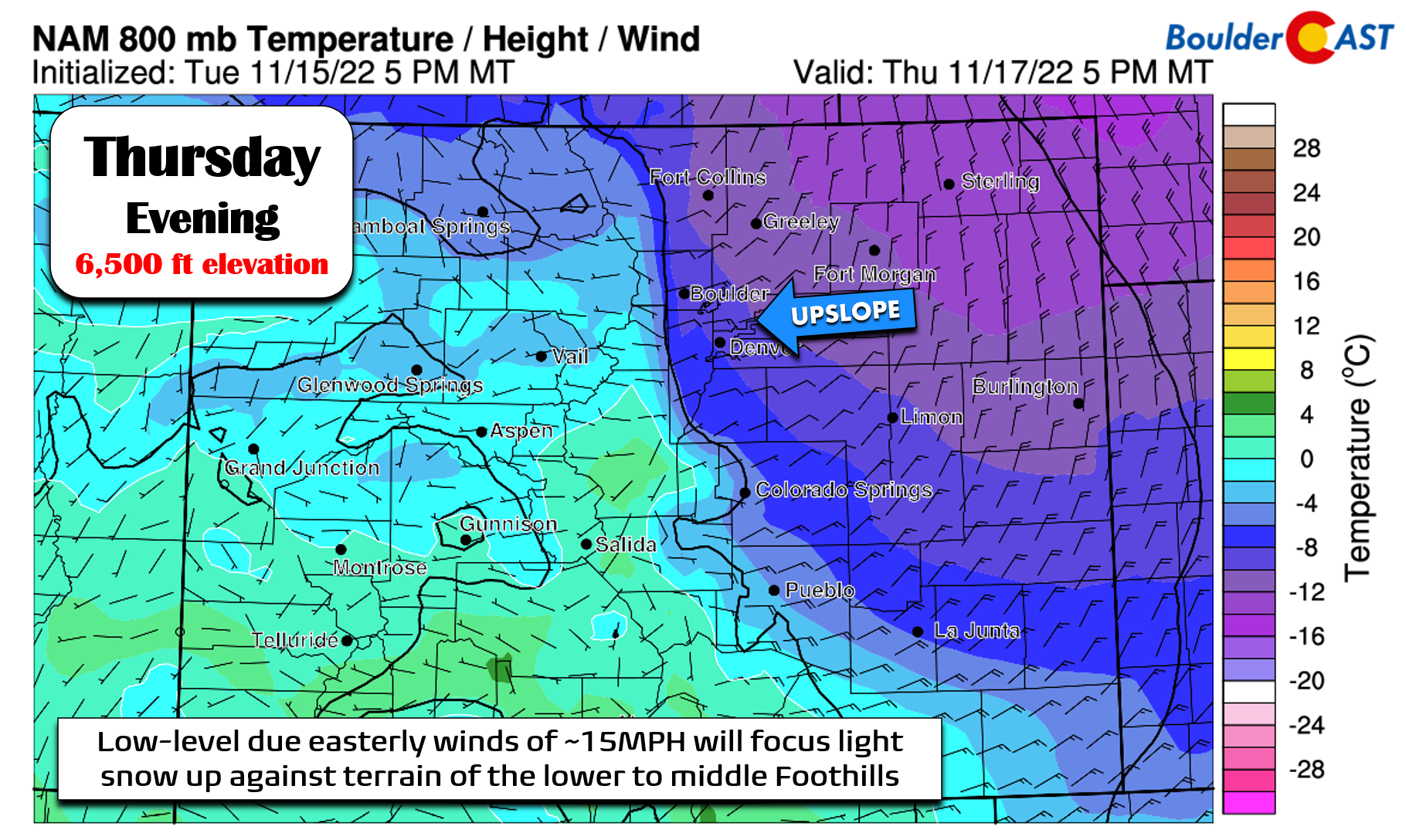
However, if we scoot up to 10,000 feet elevation (the 700mb level), we see there’s no upslope to speak of! Equally strong, almost due westerly winds are noted. The true Arctic air is not reaching this level. It’s too shallow and downslope here will inhibit snowfall production for the higher Foothills and eastern faces of the Continental Divide.

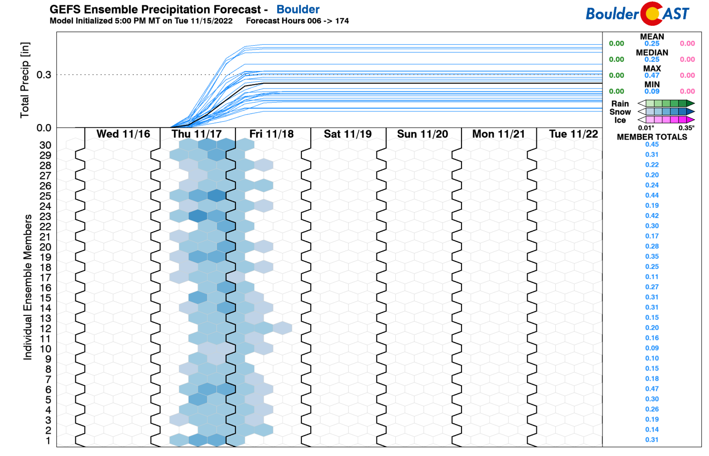
A look at the latest GFS plumes shows Boulder is well-positioned to received around 0.25″ of liquid equivalent precipitation from this event. With snow ratios of 17:1 or even a bit higher, this will translate to about 5″ of snow. We actually believe the GFS could be slightly underestimating just how efficient the upslope will be producing snow in Boulder (other models like the Euro are higher), so 5″ is perhaps on the low side.
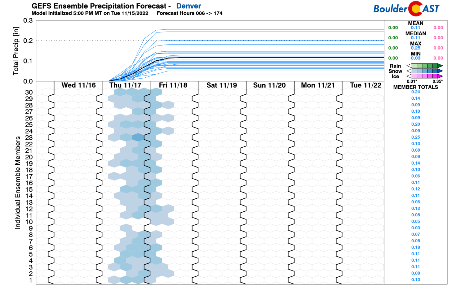
Denver will receive notably less white stuff than Boulder from this event. The plumes indicate around 0.15″ of moisture there, translating to about 2 to 3″ of snow.
All things considered, Boulder and the lower Foothills below ~7500 feet elevation are most favored from this storm due to the shallowness of the Arctic airmass and upslope. With the cold air lending to fluffy snow ratios, we are expecting 6-11″ in these areas. Elsewhere, 2-7″ will be common, with much of the central/eastern Denver Metro likely on the lower end of that range. Our snowfall forecast map for the event is shown below, summarizing graphically the things we have discussed so far (map updated 11/17/22 7:00 AM):

Expect light snow to drop southward across the area through the day Thursday. It will be snowing around Fort Collins before sunrise and should reach Boulder and Denver during the morning hours. This timeline could accelerate a bit, given how the models have been racing this front through of late. Expect at least moderate impacts to the Thursday evening commute. The most significant commute impacts will come Friday morning which will follow a long night of persistent snowfall accumulating on very cold roadways. Due to the potential travel impacts, the National Weather Service has issued a Winter Weather Advisory for the entire Front Range. Travel will be hampered anywhere from Castle Rock to Cheyenne through Friday morning.
The other story with this event will be the cold temperatures — certainly the coldest air of the season thus far. In fact, temperatures could drop into the single digits by sunrise Friday — especially in areas that have lesser snow falling. The last single-digit temperature reading in Boulder was way back on March 11th. Yes, brace yourself now for the coldest temperatures we’ve had in more than eight months! Snow should wrap up during the morning hours Friday as the Arctic high pressure weakens and upslope fades. Highs on Friday will struggle to get out of the teens despite some sunshine developing during the afternoon. We won’t get back above freezing until sometime Saturday afternoon — some 66 hours or so after we first dropped below that mark.

For our Premium subscribers, we’ll post another storm update on the situation later this evening or tomorrow morning summarizing our final thoughts and latest model trends before the snowflakes start flying, so do check back.
Stay warm and enjoy the Arctic blast!
Get BoulderCAST updates delivered to your inbox:
Enjoy our content? Give it a share!


You must be logged in to post a comment.