Mother Nature just won’t cut us a break in 2022! Can you believe that another Arctic blast is headed our way with more snow and even colder temperatures. The Arctic front arrives before dawn on Wednesday and will be followed by an extended period of snow. Snow could be heavy at times Wednesday afternoon into the evening, and may not fully wrap up until Thursday afternoon. We discuss the setup, timing, and likely snowfall amounts as another frigid airmass ominously descends on the Front Range.
Premium Storm Update (3/9/22 7:00AM): Overnight model runs have further confirmed the chance for scattered heavy snow bands to develop Wednesday afternoon and evening. We discuss the latest on the storm as snow has already begun falling from Boulder County northward. READ HERE
At a Glance:
- Yet another Arctic blast will engulf the Front Range Wednesday through Friday with much colder temperatures and you guess it…snow!
- A cold front surges through the area before sunrise Wednesday morning with temperatures in the teens thereafter
- Flurries/light snow develop Wednesday morning, but the main event will be Wednesday during the afternoon and evening when scattered heavy snow bands will be possible
- Light upslope snow lingers across the northwestern Metro area into Thursday, perhaps not ending until the afternoon hours
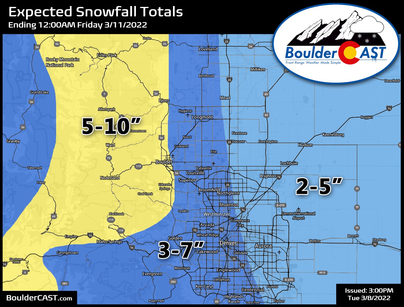
- Expected snowfall totals of 5 to 8″ in Boulder, 2-5″ in Denver, and 5-10″ in the Foothills
- Travel safe! The Wednesday PM and Thursday AM commutes will be slick and snowy
- Bitter cold temperatures through Friday with a chance at below zero readings Friday morning
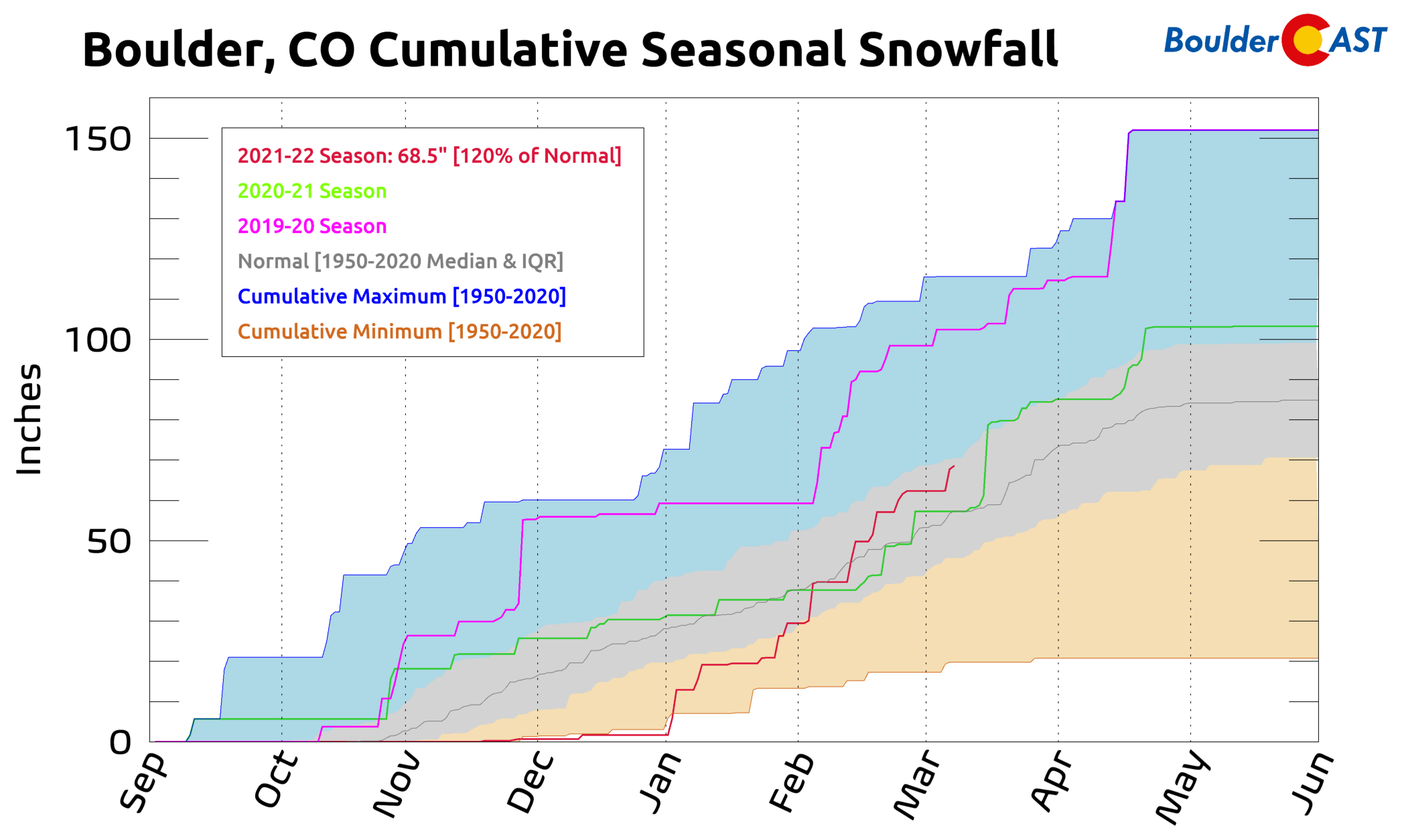
Thanks to this past weekend’s snowstorm, both Boulder and Denver are now sitting pretty with above normal snowfall for the season so far!
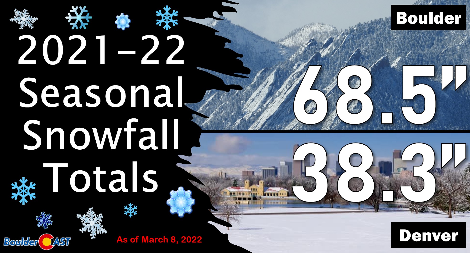
Boulder has remarkably seen 68.5″ of snow this season — most of which came since December 31st. This is about 10″ above normal as of March 7th. As you can see below, the amount of snow that has fallen in 2021-22 (red line) is higher than last winter at this point (green line), but far below the record-setting 2019-20 season (magenta line).
As we touched on in our weekly outlook, more white stuff is headed our way Wednesday as yet another Arctic airmass eyes the Front Range — coming straight to us from central Canada. In addition to more accumulating snow, bitter cold temperatures will take over Wednesday through Friday. The forecast animation below shows the evolution of the broad trough across the Rockies. The system develops quickly but takes a few days to fully push south and east across Colorado. Get ready for a multi-day stretch of winter weather!
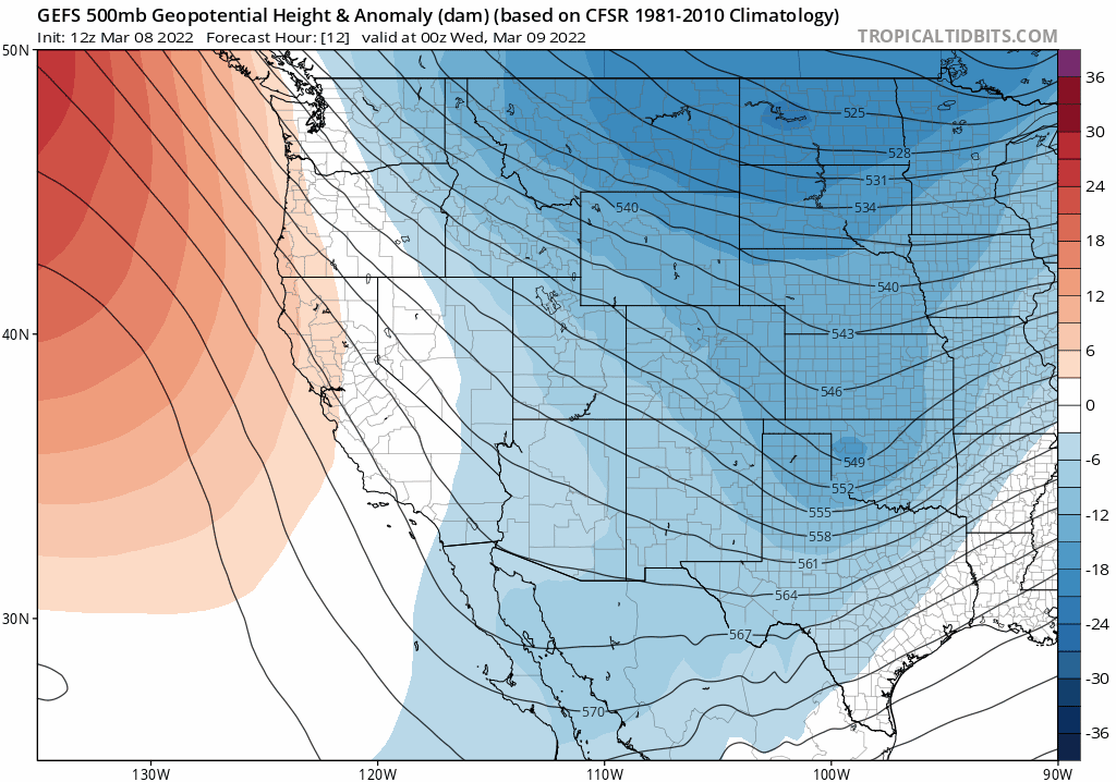
GFS ensemble mean 500mb height anomaly forecast showing the potent trough dropping straight south into Colorado out of Canada
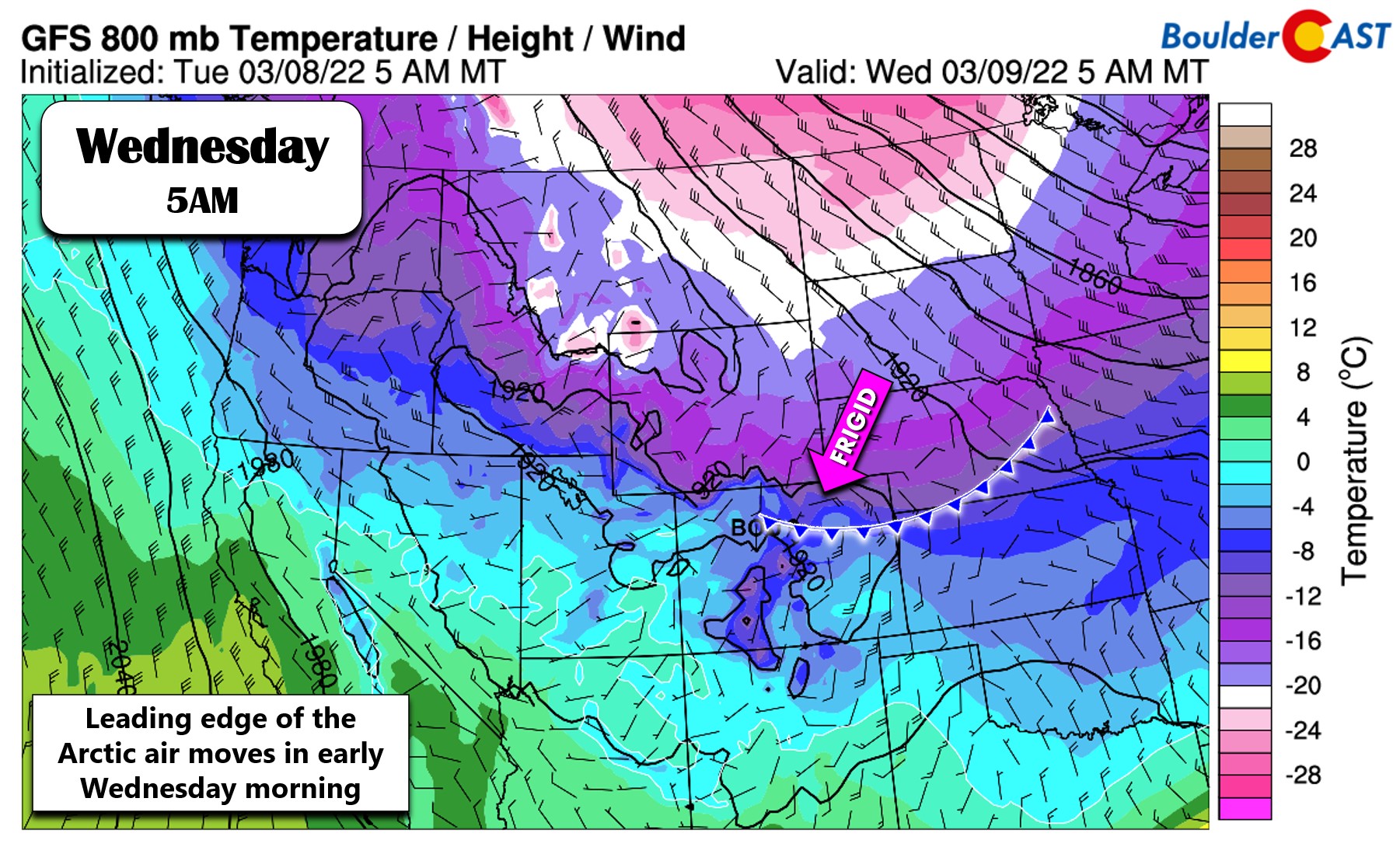
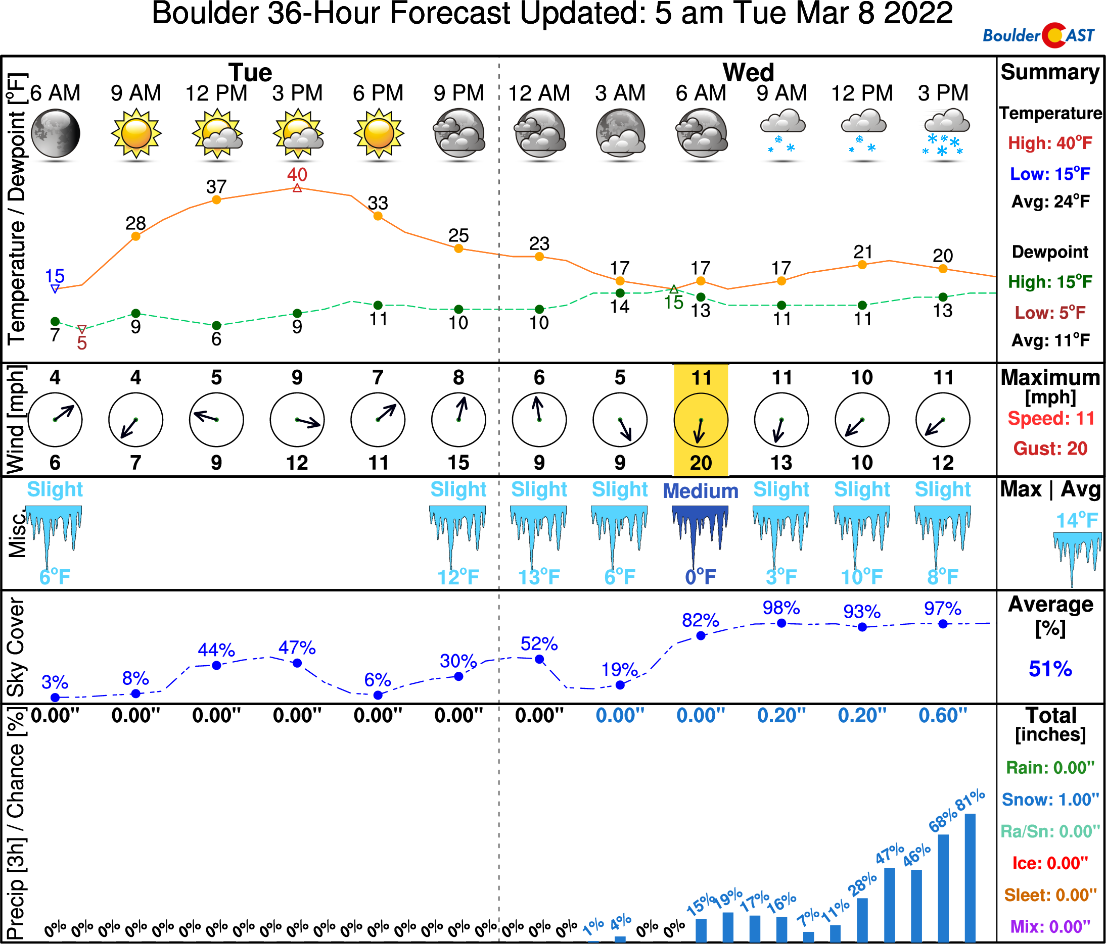
The Arctic airmass has been slowly sagging southward through Wyoming on Tuesday and will arrive into the Denver area early Wednesday morning, likely before sunrise. Models continue to trend earlier and colder with this front. High temperatures will occur in the pre-dawn hours and will only be in the 20’s. Frigid air will work in from the north keeping temperatures largely in the teens during the day Wednesday. It will get even colder into the single digits Wednesday night with sub-zero wind chills in some locations. The graphic below shows the approximate position of the cold front at 5:00AM on Wednesday as forecast by the GFS model.
It will take several hours once the front passes before snowfall commences across the Denver area. Once the atmosphere moistens up, we should see flurries or light snow break out during the morning hours on Wednesday from north to south. We talked previously about the potential for freezing drizzle at the onset of this event, but that doesn’t appear to be in the cards anymore because of how quickly the atmosphere cools — precipitation with this system will be all snow!
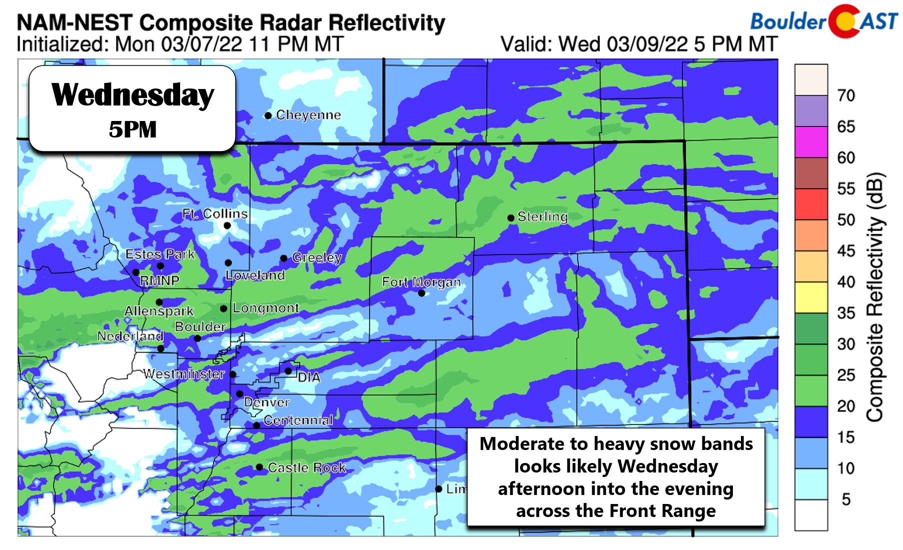
Things begin to get interesting during the afternoon into the evening on Wednesday, with all signs pointing to the potential for scattered heavy snow bands across the Denver Metro area. The main forcing will be the slow-moving cold front — enhanced frontogenesis will lead to a situation where southeast and northwest flow clash right over northeast Colorado. Steep lapse rates from the surface up to 11,000 feet elevation will supply some instability to the mix as well. There also could to be some jet forcing or even coupling involved which will help to boost the chances for banding. The most likely window for bursts of heavy snow is from 1PM to 8PM on Wednesday. We know… that’s a fairly broad range, but there still is some model variation on timing. We do expect deteriorating travel conditions before and during the evening commute. Plan for a slow and slick drive home on Wednesday evening!
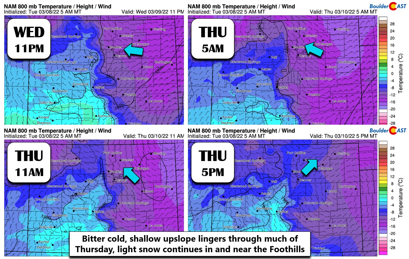
After the best forcing exits towards southeast Colorado, upslope will still be present across the Front Range through Wednesday night and much of Thursday. This will be enough to keep light snow going across the area, with the best enhancement west of Interstate 25 and north of Interstate 70. The panels below show the low-level winds and temperatures Wednesday night into Thursday evening. Note that initially winds are close to easterly Wednesday at 11PM — that’s good upslope! However, winds veer to southeasterly on Thursday. This transition will push the lingering upslope snow northward, with much of the snow focusing on Boulder and Larimer Counties during the back half of the event. Eventually by Thursday evening upslope will be essentially gone and snow should come to an end fully for the area.
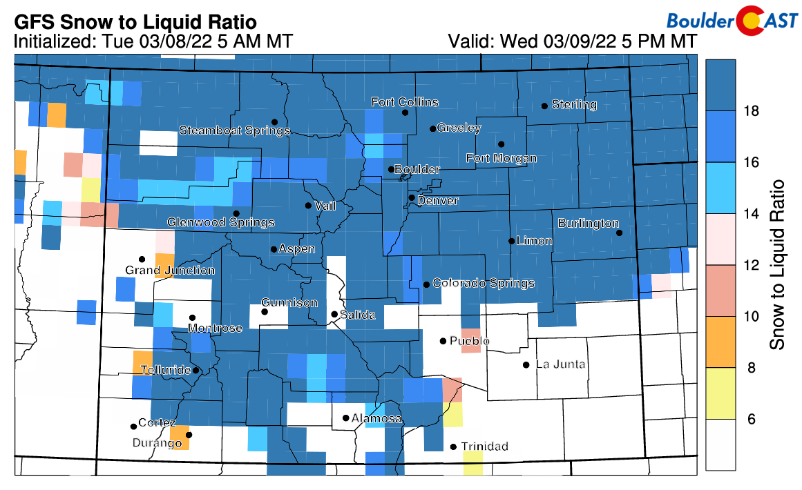
The snow that falls will be very fluffy — something that seems to be a running theme this winter — a result of most storms being accompanied by frigid Arctic air. This event will be no different. We’re anticipating snow ratios of 17:1 or higher Wednesday into Thursday. The graphic below shows our algorithm forecasting snow ratios Wednesday evening. Bring on the fluff!
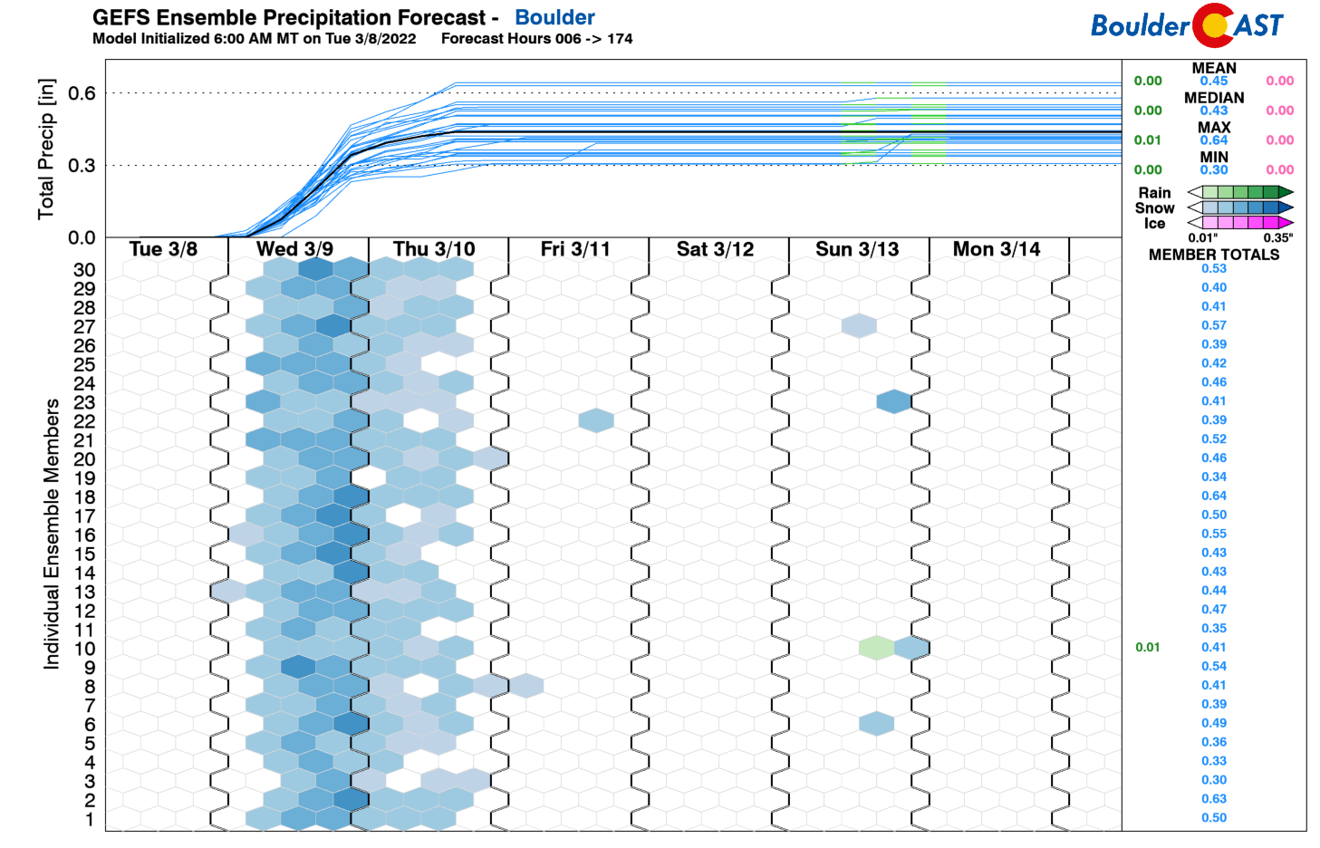
In terms of snowfall amounts, we’re looking at several inches up and down the Front Range. In fact, we expect snow to blanket most of Colorado from this system! The GFS ensemble precipitation forecast for Boulder is shown below. Ensemble members are clustered between 0.3 and 0.5″ of liquid — a healthy dose of moisture indeed!
Downtown Denver is a bit lower with a range from 0.15 to 0.3″ of liquid.
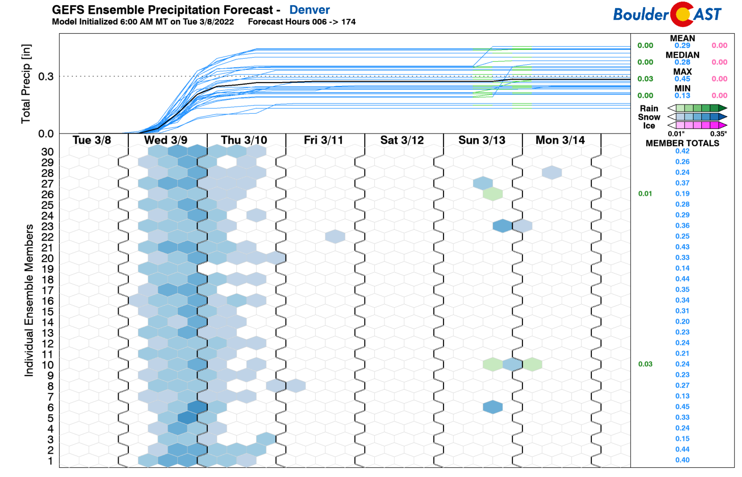
Just using the simple 17:1 snowfall ratio, this all produces totals of 5 to 9″ in Boulder and 2 to 6″ in Denver. Most of the weather models, from the GFS and Euro, to the higher-resolution ones like the RAP and HRRR, land in this range as well increasing overall confidence on amounts.
Our snowfall forecast map for this event is shown below. Remember this is a long duration snowstorm, especially for Boulder and the northern Foothills. Snow could begin as early as Wednesday morning but may not fully cease until Thursday afternoon or so — that’s a 30-hour period of snow!
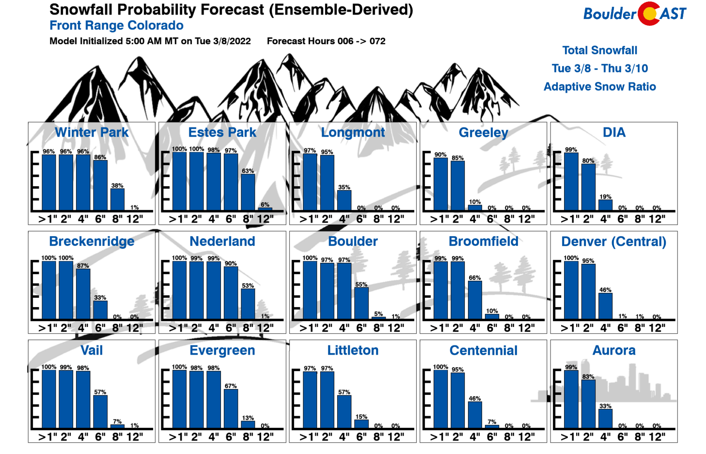
Back by popular demand, here are the snowfall probabilities: There’s a near 100% chance of at least 4″ in Boulder, with a 55% chance of 6″ or more.
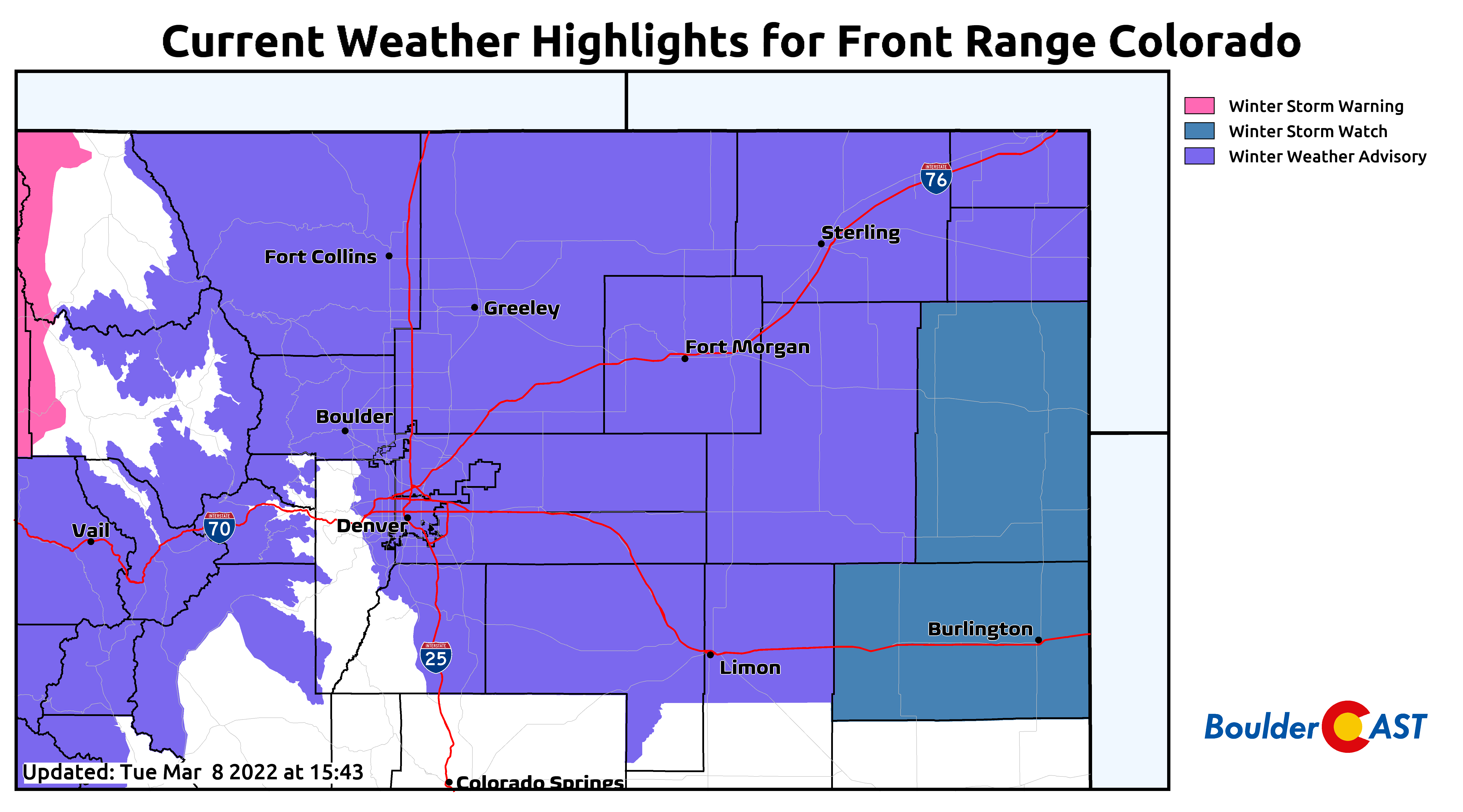
Finally, we must mention that the National Weather Service has issued Winter Weather Advisories for nearly all of northeast Colorado (everywhere but the Jefferson County Foothills). There are no Winter Storm Warnings in our neck of the woods due to the prolonged and light nature of the snow. Curiously, the National Weather Service lumps Boulder in with Denver predicting only 2-5″ of snow by Thursday evening. That may be an okay forecast for Denver, but we think Boulder is all but guaranteed at least 5″ from this event given the upslope duration and high snow ratios alone. We shall see…
In addition to the snow, temperatures will be darn cold for the next few days as well as the Arctic airmass once again tightens its grasp on the Front Range. Look for daytime highs in the teens Wednesday and Thursday and then “warming” back to near freezing for Friday. We also have a decent chance of tumbling below zero Friday morning if skies clear out enough and winds stay light. That’s not a given though.
Stay toasty and have a good rest of the week!
Get BoulderCAST updates delivered to your inbox:
Help support our team of Front Range weather bloggers by joining BoulderCAST Premium. We talk Boulder and Denver weather every single day. Sign up now to get access to our daily forecast discussions each morning, complete six-day skiing and hiking forecasts powered by machine learning, first-class access to all our Colorado-focused high-resolution weather graphics, bonus storm updates and much more! Or not, we just appreciate your readership!

Enjoy our content? Give it a share!


You must be logged in to post a comment.