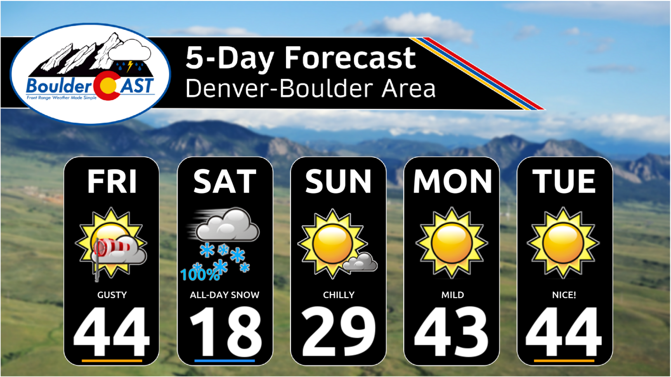
We haven’t really seen much melting of the more than a foot of snow that fell last weekend in Boulder, but additional white stuff is indeed on the way this weekend! A slow-moving storm system will bring relatively light but long-lasting snow to the area Friday night into Saturday night, with a heavy focus on the northern Front Range this time (Boulder and Larimer Counties). Some locations could see upwards of a foot of snow as temperatures plummet back into the teens for Saturday. Let’s take a look!
At a Glance
- A weak storm system will stall out across Colorado Friday night through Saturday leading to a long-duration cold and fluffy snowfall event for the Front Range
- The best forcings will be present north and west of Denver, with Boulder and Larimer Counties highly favored for the most snow from this event
- Snow will spread into the Mountains Friday evening and into the Metro area after midnight Friday night, with snow eventually waning Saturday evening
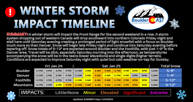
- Snowfall totals of 5-12″ are expected for Boulder and the Foothills, with 1-6″ elsewhere in the Denver Metro area, lowest east and south.
- Travel will be difficult late Friday night through Saturday with snow-covered roadways widespread as temperatures sit in the teens
- Sunday and into early next week will be quiet with temperatures slowly moderating.
Daily Forecast Updates
Get our daily forecast discussion every morning delivered to your inbox.
All Our Model Data
Access to all our Colorado-centric high-resolution weather model graphics. Seriously — every one!
Ski & Hiking Forecasts
6-day forecasts for all the Colorado ski resorts, plus more than 120 hiking trails, including every 14er.
Smoke Forecasts
Wildfire smoke concentration predictions up to 72 hours into the future.
Exclusive Content
Weekend outlooks every Thursday, bonus storm updates, historical data and much more!
No Advertisements
Enjoy ad-free viewing on the entire site.
Another bout of weekend snow
We’ve been discussing this incoming snow chance since our weekly outlook posted back on Monday, with cautious optimism that this system would hold together and deliver yet another helping of snow for the Front Range. That’s exactly what we are here to discuss today, though some of our readers will get much more snow than others with this one!
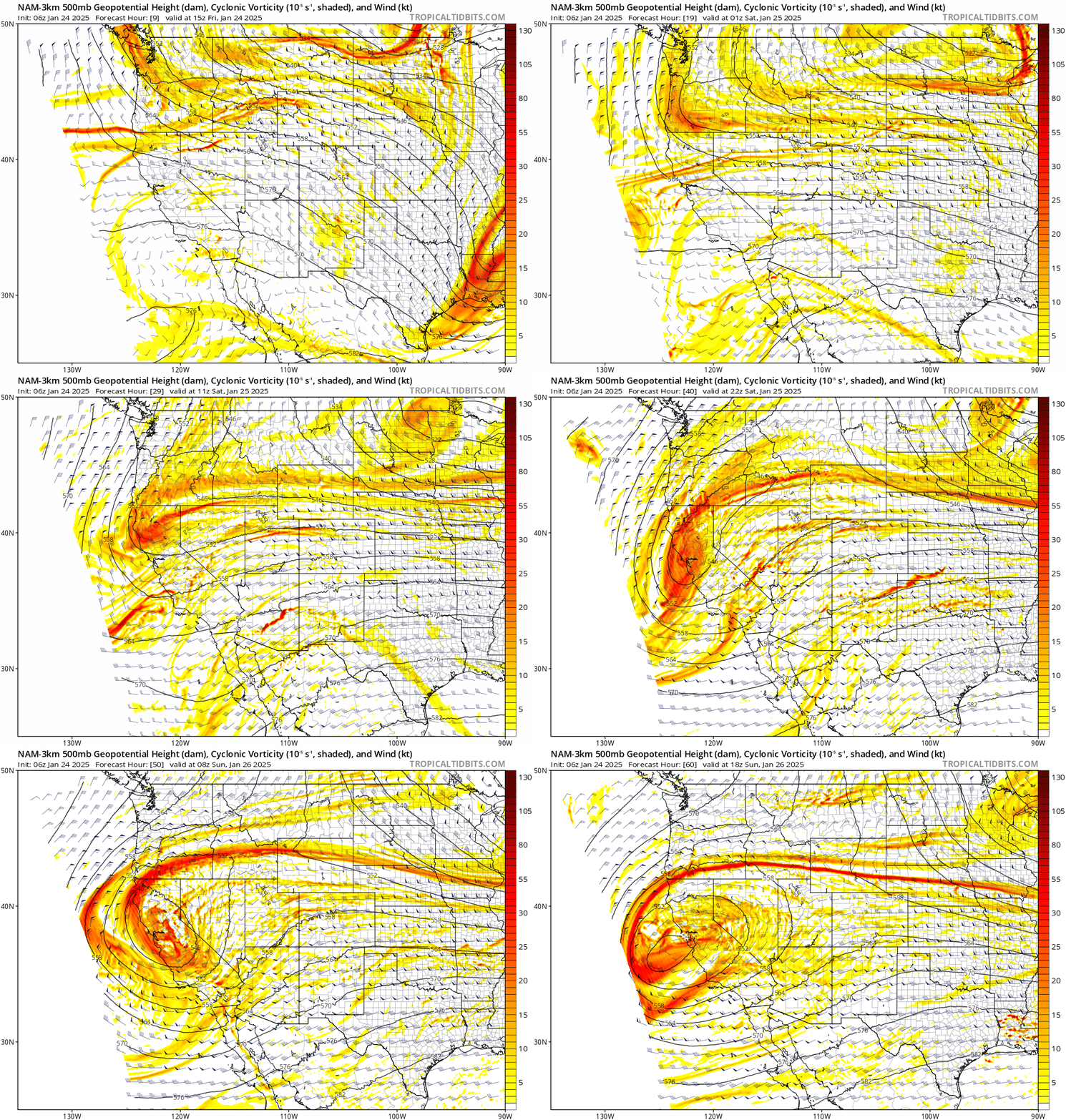
The broader atmospheric pattern is quite different than what accompanied last weekend’s Arctic Blast and one-two punch of snowstorms. During the day Friday into Friday night, a weak trough will dig southward across the Intermountain West before stalling almost perfectly through northern Colorado while at the same time a cut-off low leisurely forms in northern California into Saturday night. As this upper-level pattern unfolds, a surface cold front, packed with cold Canadian air on its backside, will blast into eastern Colorado Friday evening setting the stage for a prolonged period of light snow.
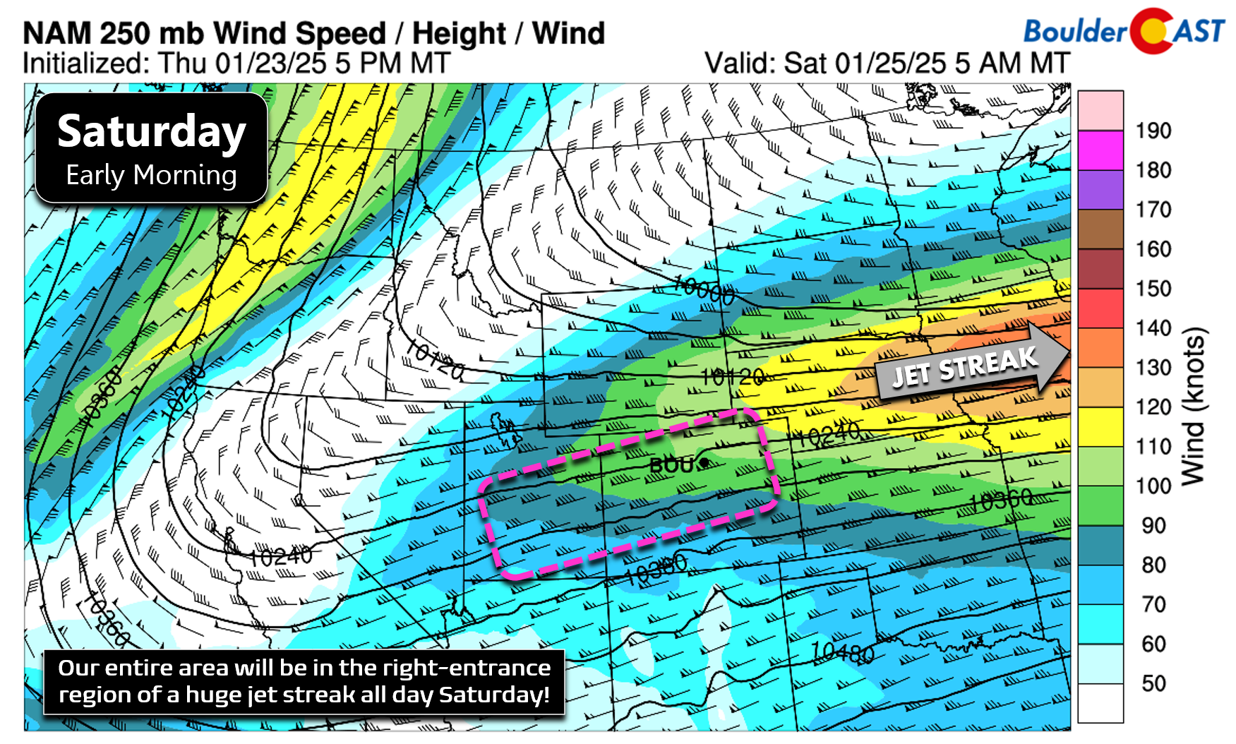
Despite the initial cold front arriving during the afternoon/evening hours on Friday, the lower atmosphere east of the Mountains will remain quite dry initially, with snow not likely to be break out until after midnight for Boulder and Denver as things all come together. The air will moisten up much quicker in the Mountains so snow will be starting up there by Friday evening. We must admit that all of the factors forcing the snowfall with this event area relatively weak — shallow upslope flow, the lift from the stalled trough axis, and weak dynamics introduced by a nearby (also stalled) jet streak — all of them are lackluster but together will allow for a lengthy period of snow in the Boulder area as the ingredients basically stall over our area for nearly 24 hours before waning Saturday evening.
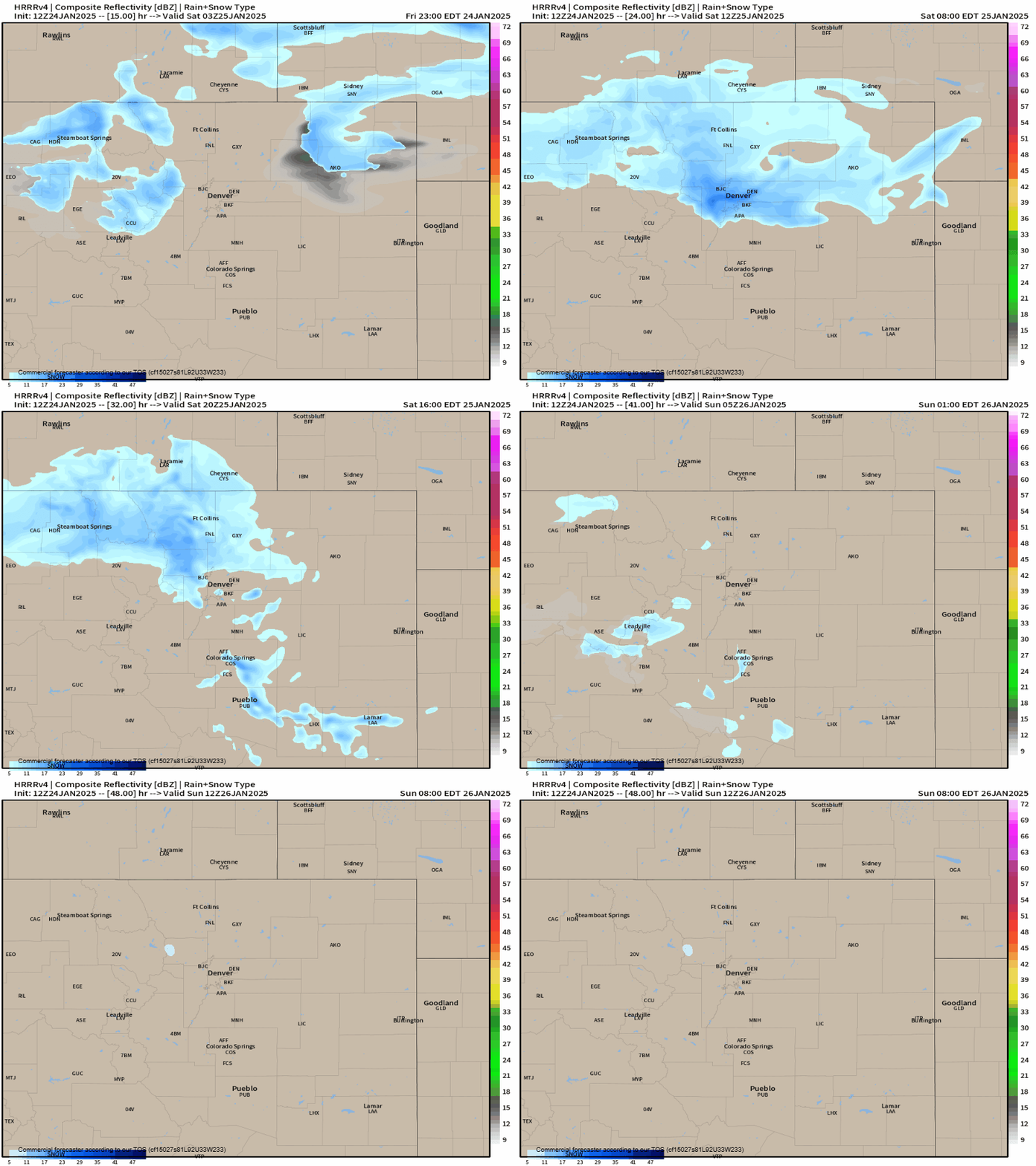
The HRRR model-simulated radar forecast below shows us how the event ahead may unfold. A band of snowfall is expected to blast southward across the Front Range after midnight Friday night — this band is associated with a secondary push of much colder air allowing for a brief period of frontal forcing and heavier snowfall rates, perhaps up to 1″ per hour during the wee morning hours on Saturday. This secondary front will also help to moisten the low-levels to allow for widespread snow on its backside. The aforementioned weak forcing factors will the remain on the table throughout the day Saturday keeping light snowfall going through most of the day.
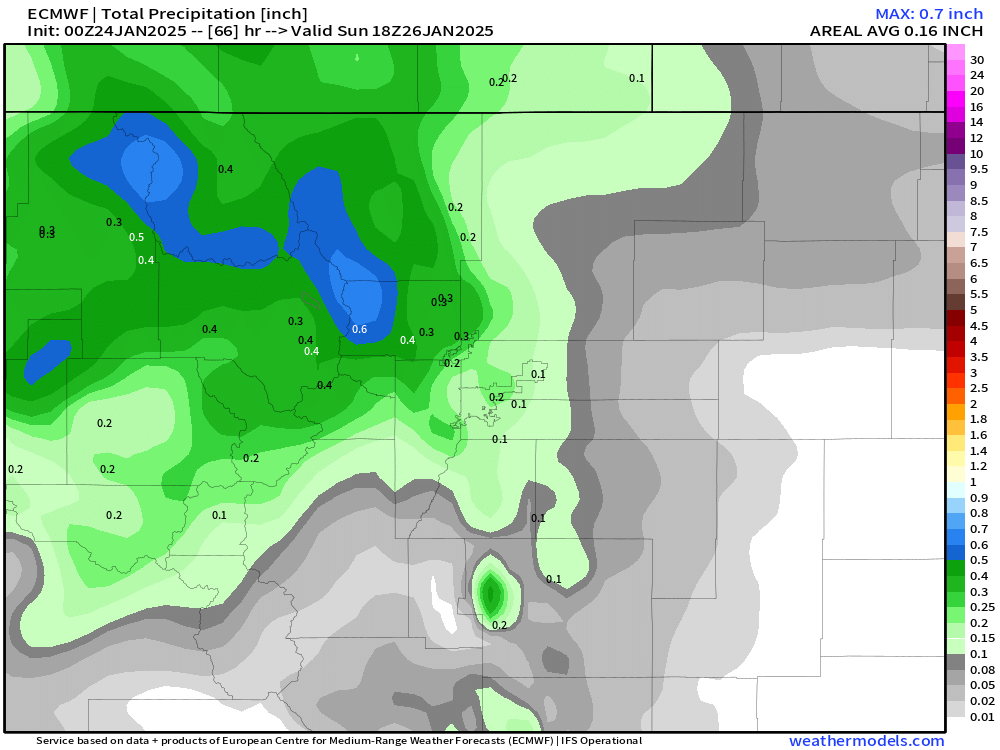
Because of the way the broader trough stalls out precisely across northern Colorado and southern Wyoming, this event will heavily favor areas north of Interstate 70 and west of Interstate 25, with much less snow falling elsewhere. Models have been very consistent the last few days with a precipitation bullseye targeting Boulder and Larimer Counties. The latest run of of the Euro model below demonstrates this facet. We’re expecting greater than 0.5″ of moisture in the Foothills of Boulder and Larimer Counties, but generally only 0.1 to 0.2″ in other parts of the Denver Metro area.
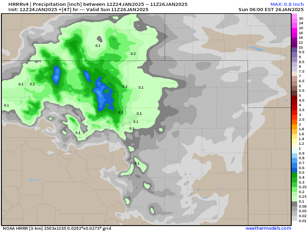
This precipitation distribution is also echoed by the ensembles and short-range guidance, with the HRRR model even including Boulder in the exclusive 0.5″ club:
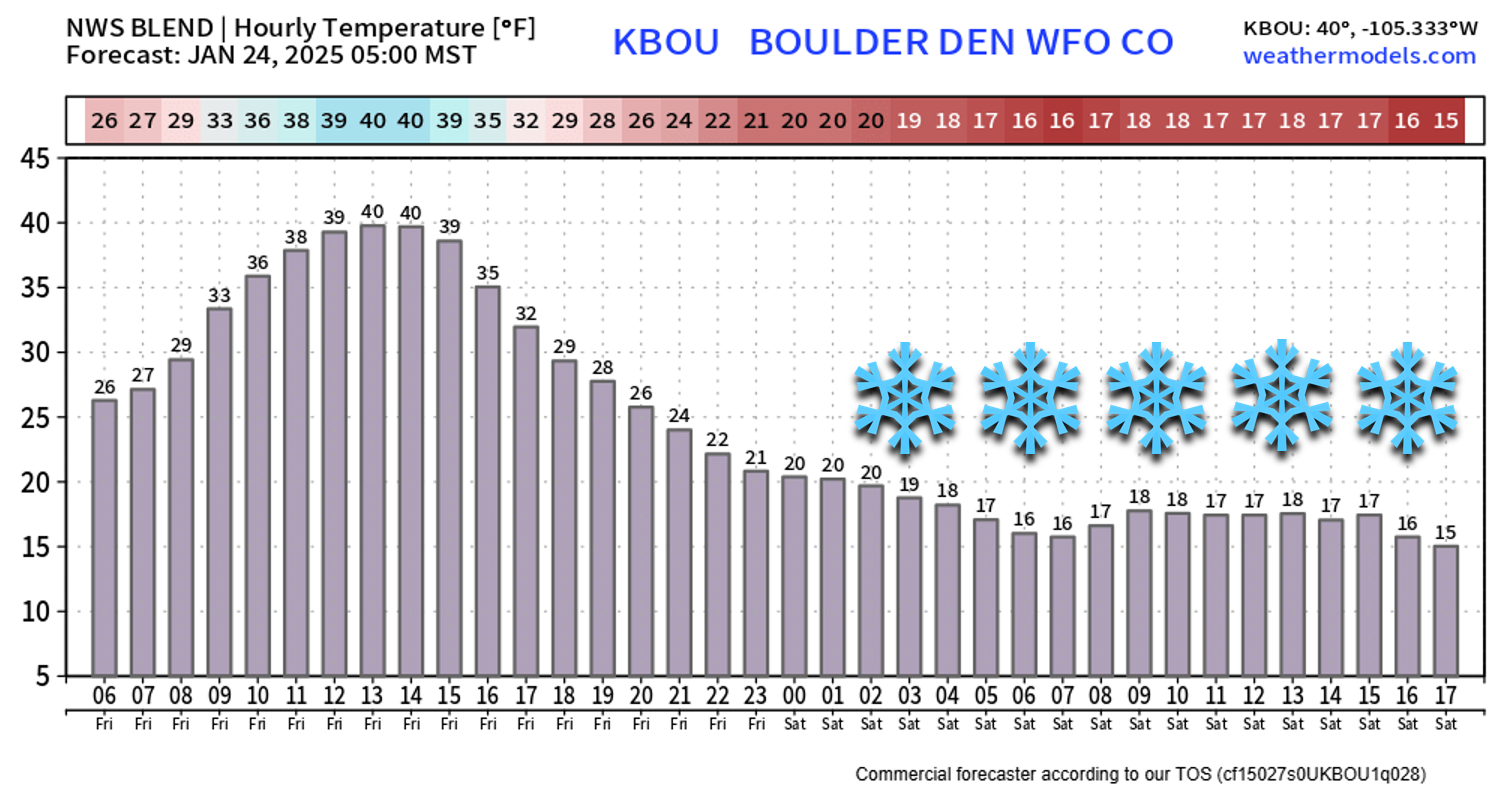
Temperatures on Saturday will be bitter cold as snow falls across the area, once again allowing for fairly generous snowfall ratios of ~15:1 or higher. High temperatures on Saturday will occur at midnight (around 20°F) before falling into and remaining in the teens throughout the day.
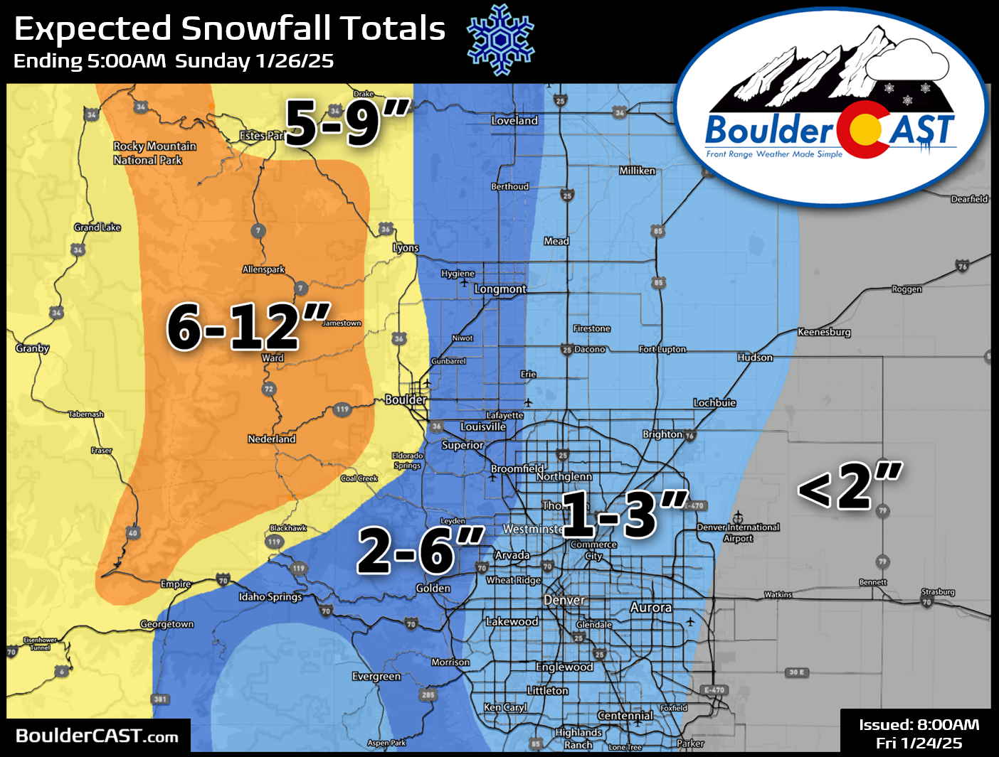
Our snowfall forecast map for this event is shown below. The highest amounts will be across the Foothills of Boulder and Larimer Counties, including immediately adjacent lower elevation cities like Boulder, where 5 to 12″ of snow is expected! Elsewhere, totals of 1-3″ will fall in Denver and areas south of Interstate 70. The in-between region will see 2-6″, including Longmont, Broomfield, and Golden .
Snowfall will begin in the Mountains Friday early evening and will eventually spread across the Metro area after midnight Friday night. Pockets of some heavier snow may occur during the wee morning hours, but for the most part snowfall rates will remain light but persistent, especially around Boulder. Travel will be slick throughout much of Saturday, especially in and near the Foothills. With snow lessening by late Saturday afternoon and evening, travel should become easier though likely with slick/snowy spots in Boulder County through Saturday night.
The back half of the weekend will fortunately be much quieter with sunny skies on Sunday and temperatures topping out just shy of freezing. This nice weather will carry us into next week with moderating, but still below normal, temperatures through Tuesday.
That’s all for today’s update. Come join us on Twitter, Bluesky, Facebook, and Threads for impromptu weather updates as this snowstorm unfolds, or subscribe to get notified of our long-form updates here. Stay warm and enjoy what will be yet another weekend snow day!
Get BoulderCAST updates delivered to your inbox:
Daily Forecast Updates
Get our daily forecast discussion every morning delivered to your inbox.
All Our Model Data
Access to all our Colorado-centric high-resolution weather model graphics. Seriously — every one!
Ski & Hiking Forecasts
6-day forecasts for all the Colorado ski resorts, plus more than 120 hiking trails, including every 14er.
Smoke Forecasts
Wildfire smoke concentration predictions up to 72 hours into the future.
Exclusive Content
Weekend outlooks every Thursday, bonus storm updates, historical data and much more!
No Advertisements
Enjoy ad-free viewing on the entire site.
Enjoy our content? Give it a share:





You must be logged in to post a comment.