After the recent freezing drizzle event that glazed the entire area in ice, our attention quickly turns to an approaching winter storm that will bring a round of snow to the area on Friday. We discuss the setup, timing and expected snowfall amounts in what will be an all-snow upslope event for mainly the western Denver Metro area.
Premium Storm Update (1/21/22 7:00AM): We do a final check on the latest model runs and discuss the potential for heavier bands of snow now appearing in the short-range models. We give our final thoughts on the storm and discuss the slight changes being made to our snow forecast amounts. READ HERE.
At a Glance:
- A winter storm system will drop sharply from western Canada into the Las Vegas area by Friday evening
- A cold front and interesting alignment of the trough will create a period of upslope for portions of the Front Range on Friday
- Upslope will exist mainly only in Boulder and Jefferson Counties with a strong focus in the Foothills
- Expect spotty light snow showers during the day Friday, but watch for the best upslope in the late afternoon to evening timeframe
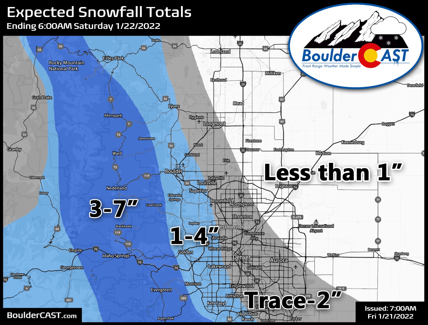
- 3-7″ of snow in the favored Foothills, but lower totals of up to 4″ in Boulder and 2″ in Denver
We discuss Boulder and Denver weather every single day on BoulderCAST Premium. Sign up today to get access to our daily forecast discussions every morning, complete six-day skiing and hiking forecasts powered by machine learning, access to all our Front Range specific weather models, additional storm updates and much more!

H
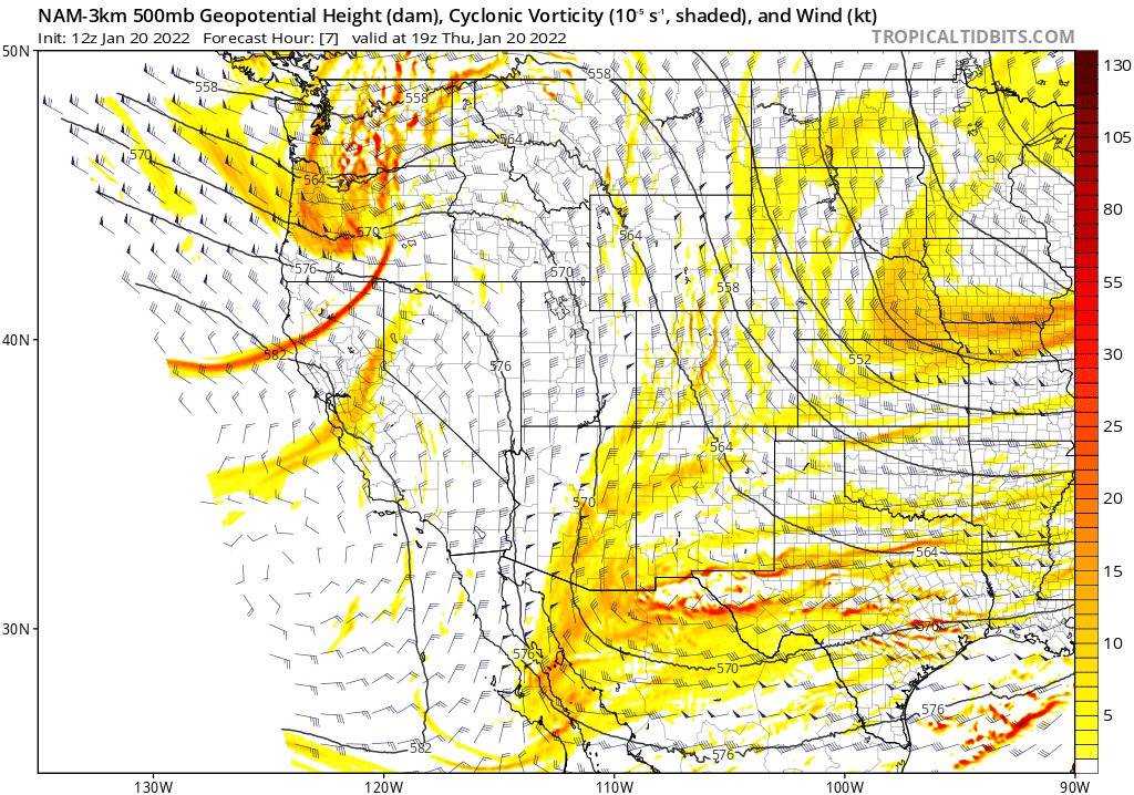
ot on the heels of the freezing drizzle event that encased everything in ice on Wednesday, another winter storm will impact Colorado during the day on Friday. This one comes in the form of essentially pure upslope — upslope which will be deeper this time allowing for an all snow affair. There will be no rain or freezing drizzle to worry about! The incoming storm is currently located way up in British Columbia as of Thursday afternoon but it will dive southward rapidly over the next 24 to 36 hours. Interestingly, this system will largely bypass Colorado. Most of the energy will follow alongside a cut-off low pressure that pinches-off near Las Vegas on Friday before taking a vacation to southern California for the weekend.
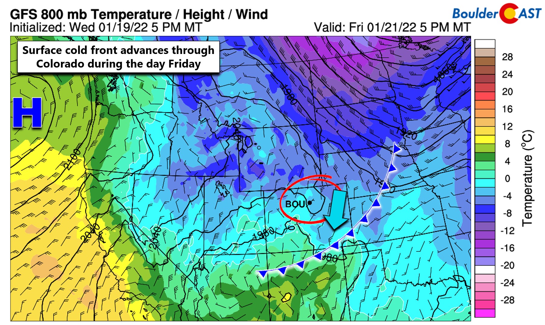
Despite how far away the storm will be, a surface cold front will still be moving southward through all of Colorado Friday morning. Note the colder temperatures and slight upslope in the near-surface forecast for Friday at 5:00PM below. At this time, the front will already be entering New Mexico.
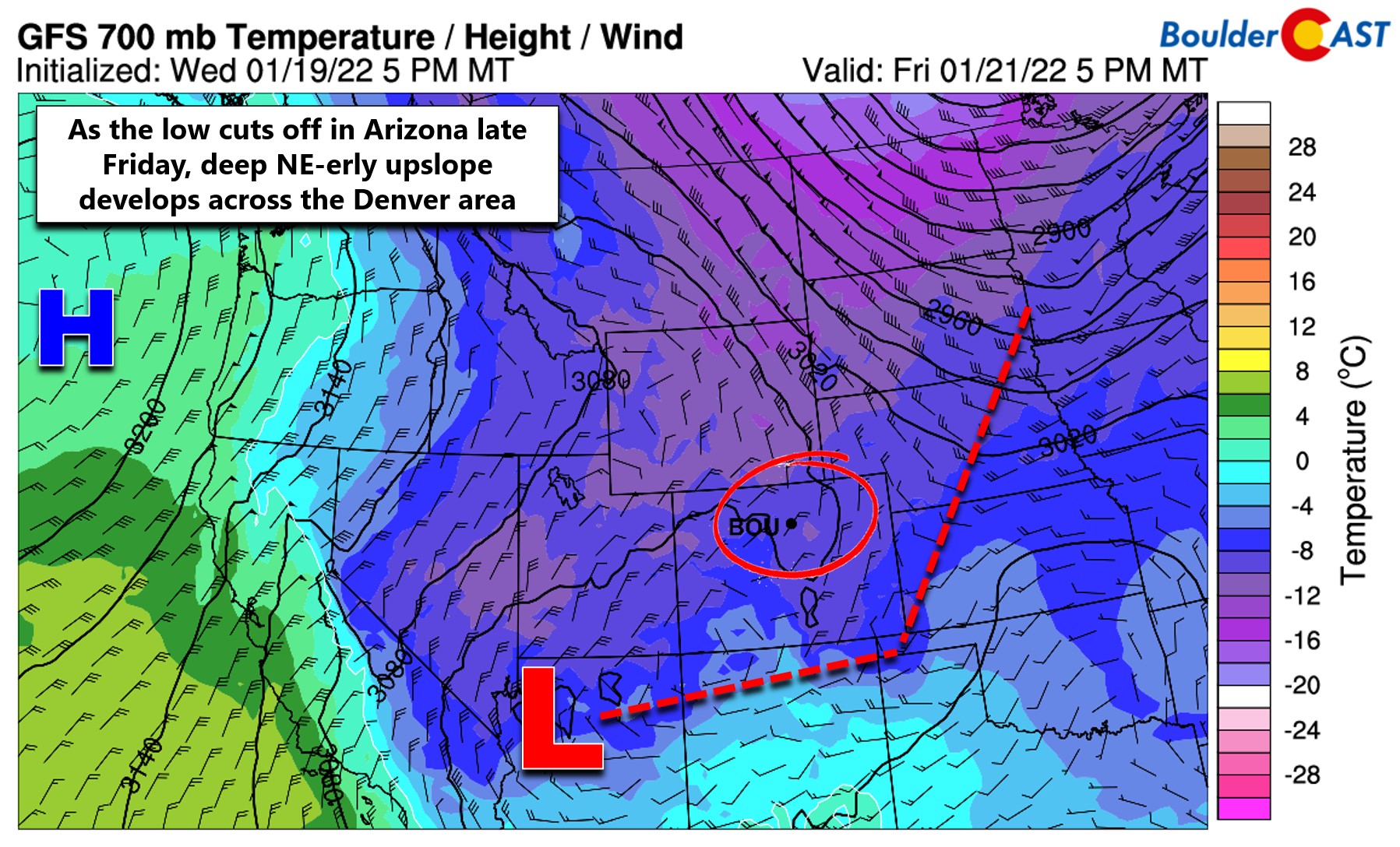
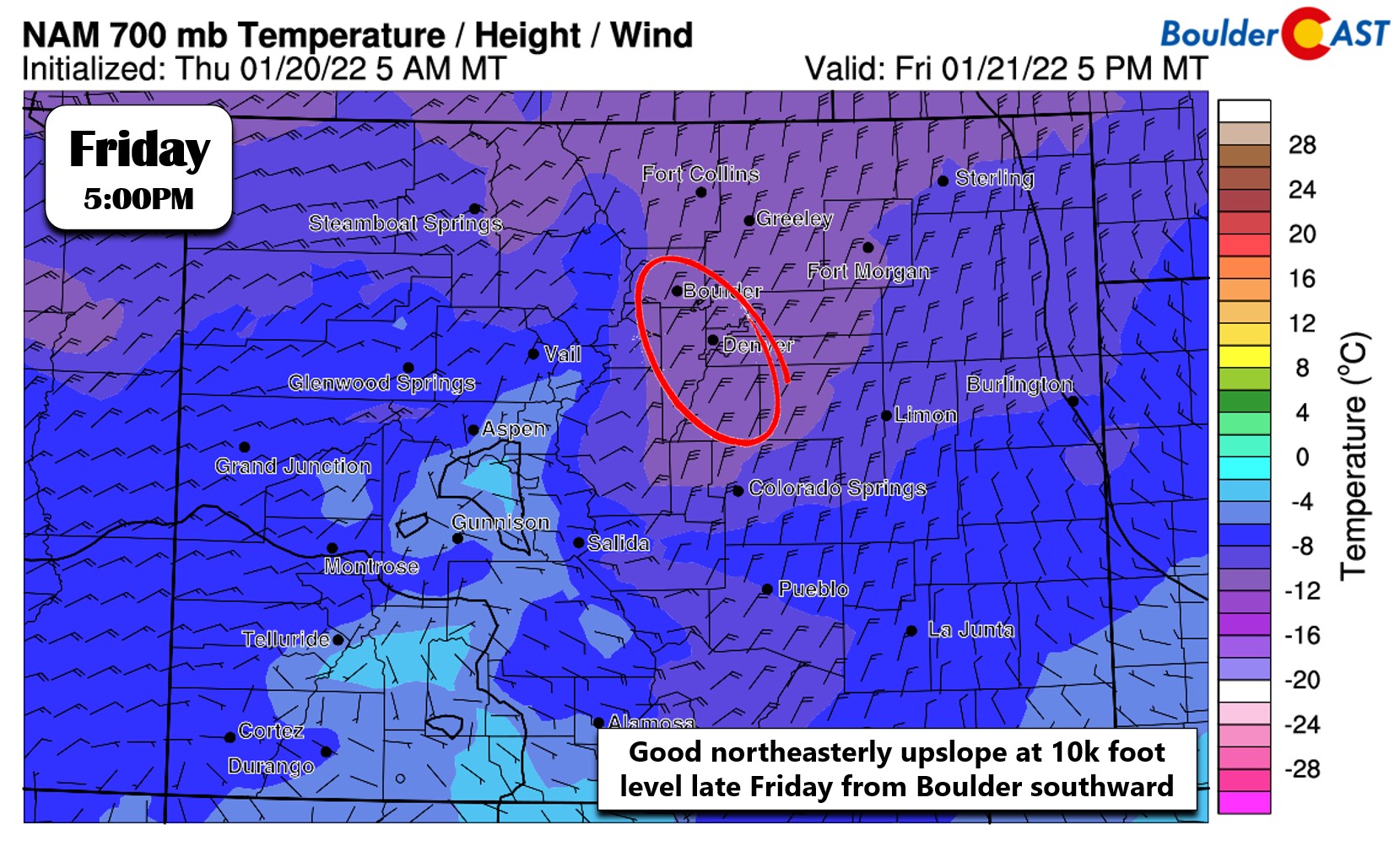
The upslope in our neck of the woods is even stronger higher up in the atmosphere on Friday. The temperature and wind forecast below is for approximately 10,000 feet elevation.
Let’s zoom in a little and take a closer look at what is happening across Colorado specifically. We see a strong surge of upslope headed to the Denver area late afternoon into the evening hours on Friday. This should produce a decent wave of snowfall, mainly focused in and near the Foothills of Boulder and Jefferson Counties, but also across the Palmer Divide. Further north, from Longmont to Fort Collins, winds will be northerly which is not upslope. Instead this is actually downslope off the Cheyenne Ridge along the Wyoming border. We’re not expecting much if any snow to fall up that way as a result.
The way the winds are lining up now, the most snow (up to several inches) from this storm will occur in the Foothills, while just meager accumulations are expected across the lower elevations. Some light and spotty snow showers may accompany the cold front during the morning to midday timeframe anywhere across the Front Range. That won’t amount to much accumulation — just a 1/2″ or less in most cases. The main wave of snow will occur in the late afternoon to evening timeframe as the strongest surge of upslope clashes with the terrain from the northeast. This will focus pockets of moderate snowfall into the Foothills and immediately adjacent Plains, possibly creating some hindrances to the evening commute in the western and southwestern suburbs. Our snowfall forecast map for the event is shown below (updated 1/21/22 7:00AM). This event could very well turn out similar to the storm exactly one week ago!
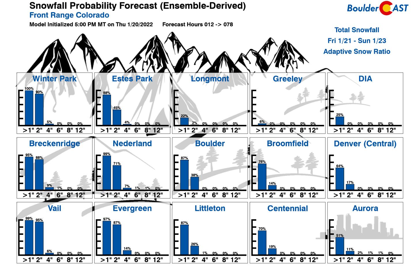
As always, we like to show our Snowfall Probabilities to give you an idea of the potential spread in outcomes for your general area (updated 1/21/22 7:00AM). Boulder has an 87% chance to pick up 1″ of snow on Friday, but things drop off rapidly from there. Compare that to downtown Denver and DIA which have only a 87% and 25% chance to see 1″ of snow, respectively. This will clearly not be a major snow event for the Denver Metro.
Models have been trending further south and west with the main storm system over the last few days. Any further and this would wipe most of the snow off the table for our area. Check back (or subscribe below) as we may update our forecast early Friday if anything major changes.
Things will clear out after midnight Friday night and early Saturday with above average temperatures returning post-haste by Sunday.
Get BoulderCAST updates delivered to your inbox:
Help support our team of Front Range weather bloggers by joining BoulderCAST Premium. We talk Boulder and Denver weather every single day. Sign up now to get access to our daily forecast discussions each morning, complete six-day skiing and hiking forecasts powered by machine learning, first-class access to all our Colorado-centric high-resolution weather graphics, bonus storm updates and much more! Or not, we just appreciate your readership!
Enjoy our content? Give it a share!


You must be logged in to post a comment.