March is definitely coming in like a LION this year! We discuss the wintry forecast across the Front Range this weekend and provide our snowfall forecast map. Spoiler alert: BIG snow totals are possible in some areas alongside extremely cold temperatures for early March.
N
o real changes are needed to the preliminary forecast we issued yesterday. Today’s discussion is more of a confirmation of what we expect to transpire over the next 72 hours as a very cold airmass and snow overtake our region.
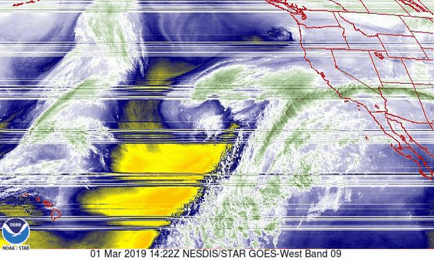
Moisture from an atmospheric river event in California is already spilling into the Mountains of Colorado. This moisture will be keeping things saturated across the state in the mid and upper levels of the atmosphere through Sunday. Water vapor imagery from GOES-West shows a deep tropical moisture plume stretching into the southwestern United States on Friday.
GOES-West water vapor animation Friday morning
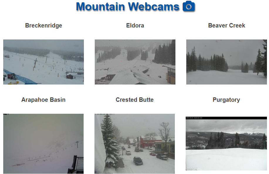
Light to moderate snow is already falling just about everywhere in the Mountains near and west of the Divide.
Two cold fronts will impact eastern Colorado with this event. The first front is somewhat tame and will enter the picture Friday afternoon to the Metro area. The secondary front is Arctic in nature and is the main player for our snow this weekend. It won’t arrive into the Boulder/Denver area until late morning or early afternoon Saturday. Temperatures behind this front will fall quickly into the lower teens and single digits.
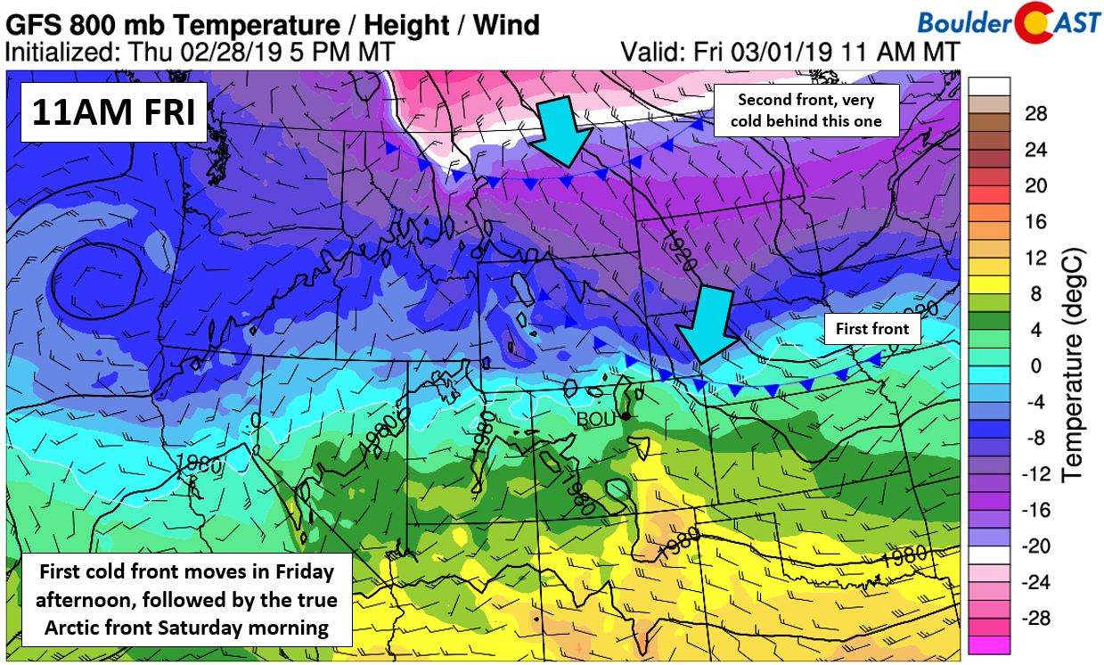
GFS 800 mb temperature map for mid-day Friday. Two fronts will be moving into our region.
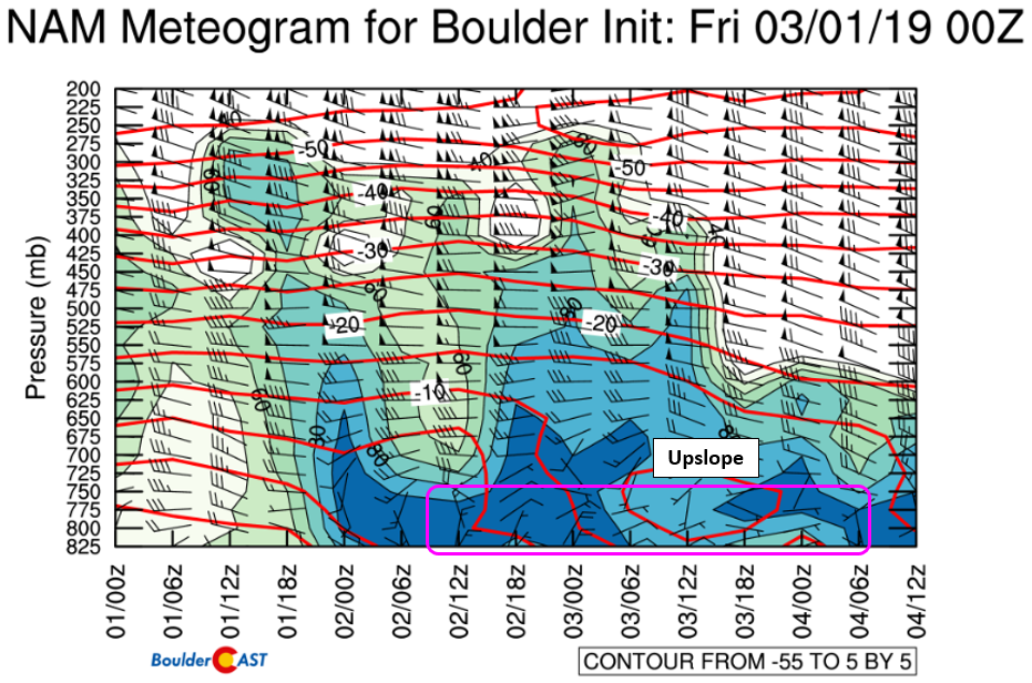
Low-level upslope will commence following the passage of the first front. However, it won’t be until the second front passes Saturday that stronger, moist northeasterly upslope will ensue. The time-height wind forecast graphic from the NAM model below shows that the most potent upslope will be from Saturday late morning until midnight Saturday night. Beyond this, though, weak low-level upslope could linger much longer, possibly all the way into Monday morning or afternoon for Boulder which will keep at least light snow in the forecast through Monday morning.
Probably the most complicated and uncertain aspect of the forecast this weekend will be the splitting sub-tropical jet stream overhead. There isn’t great agreement between any of the models right now on how this split evolves. We do know that the jet will be close enough to produce intermittent forcing to support moderate to heavy snow bands Friday night through Saturday night in our general area. However, given the uncertainty in the split-jet positioning and timing, pinning down where exactly these bands form is nearly impossible.
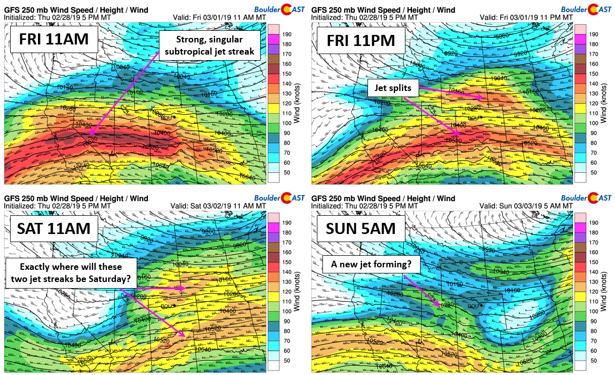
GFS 250 mb wind forecasts from Friday morning through Sunday morning
We are fairly confident that Friday night the banded snow will set up north of the Metro area which will be in the left exit of the jet. Thus, most of us should expect little to no snow accumulation Friday night. However, from Boulder northward, we could see some banding develop that puts down a quick inch of snow. From Fort Collins to Cheyenne, banding will be more widespread with 1 to 4″ expected by Saturday morning.
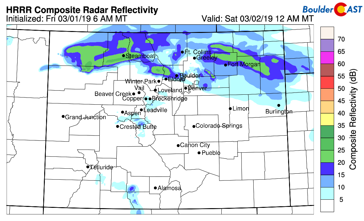
HRRR simulated radar reflectivity for midnight Friday night. Banding is expected mainly north of Denver.
As the secondary Arctic front shows up late-morning Saturday (plus or minus a few hours), we expect snowfall to become widespread across the Front Range from north to south. With efficient low-level upslope, energy from a passing trough, and the threat of the overhead jet, snowfall Saturday afternoon and evening could be heavy at times. It looks like anywhere up and down the Front Range could have the chance for these embedded bursts of heavier snow.
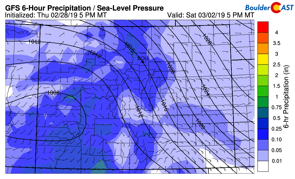
GFS pressure, surface wind, and precipitation for Saturday afternoon. Widespread snowfall is expected across the Metro area.
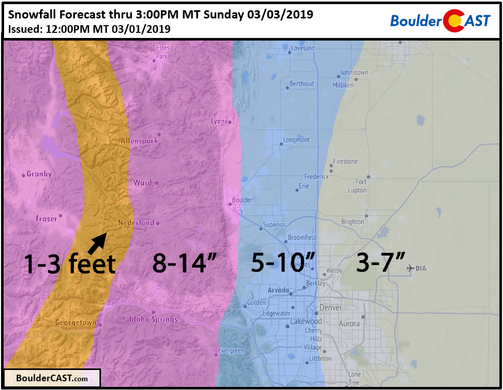
Snowfall amounts
This storm has the potential to be the biggest snow-producer for the Metro area so far this winter. Besides mostly missing out on the first wave of jet snow Friday night, we are hard-pressed to find any aspect of the storm that would tend to curb snow amounts for the Boulder/Denver area. There is PLENTY of moisture, a LONG duration of efficient upslope, periods of GOOD mid-level forcing, very COLD air, HIGH snow ratios, and the BOOM potential offered by the overhead jet stream being nearby.
The GFS model is definitely the most bullish on snow amounts right now, but the Euro and NAM are only slightly lower. At worst, we’re looking at about 0.5″ of liquid in Boulder, and 0.3″ in Denver. At best, close to 1″ in Boulder and 0.6″ in Denver. With snow ratios ranging from 15:1 to 20:1 for the event, the snow will really pile up.
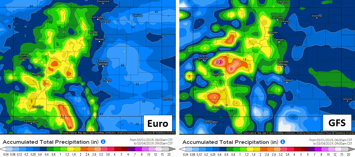
Our snowfall forecast map below covers the snow potential through Sunday afternoon. If there is enough moisture and upslope left Sunday afternoon into Monday (as many of the models are showing), a few inches of additional fluffy accumulation may be possible across the western suburbs and Foothills. Do note that our forecast is substantially higher than current highlights posted by the National Weather Service. They have a prediction of 4 to 7″ for entire Front Range lower elevations…far too low in our opinion, especially around Boulder.
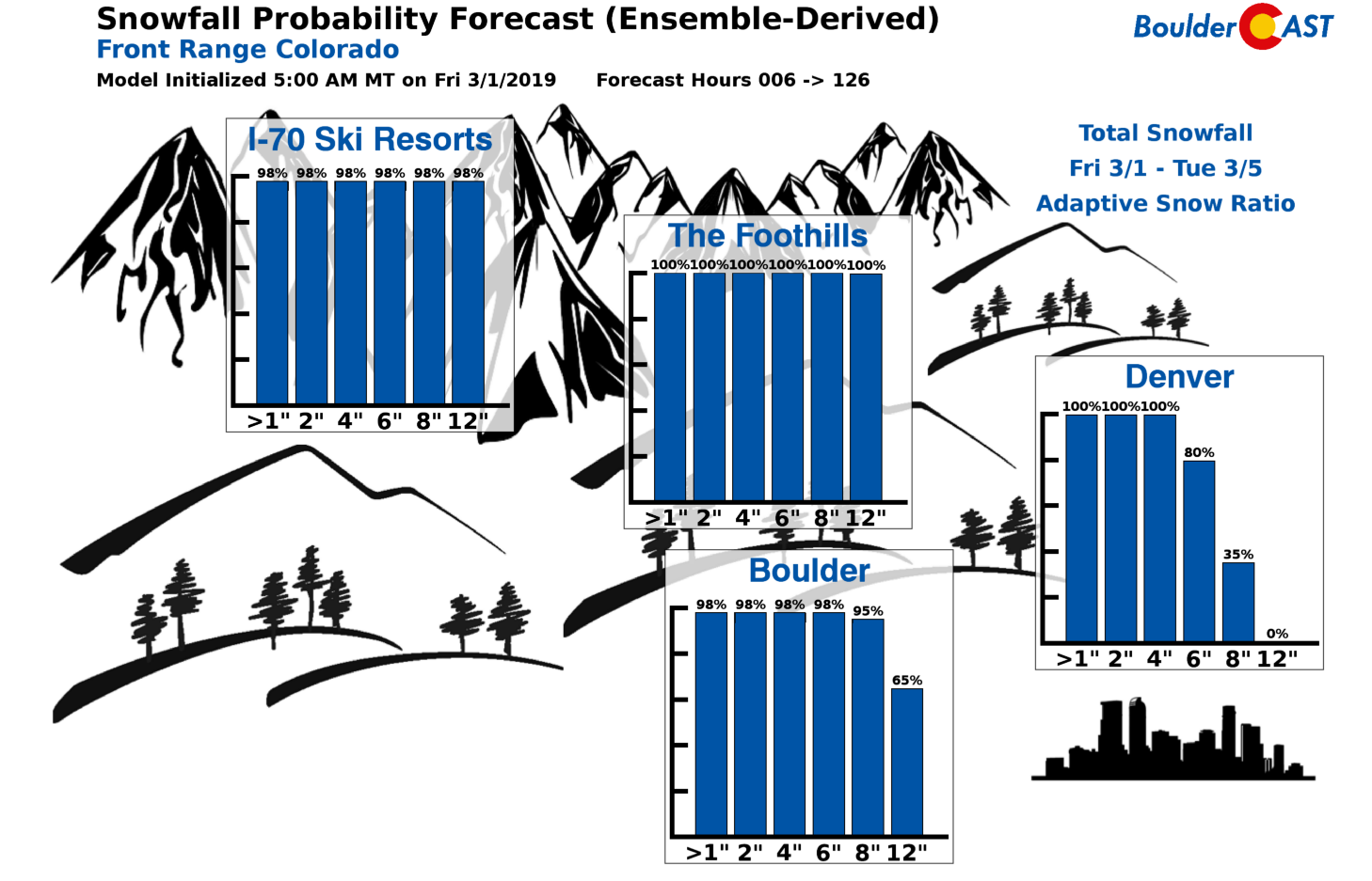
The snowfall probability charts match up quite well with our expectations for this storm:
While not impossible for early March, the lengthy period of very cold temperatures this weekend into early next week is significant in its own right. Highs Saturday will only be in the 20’s (and falling!), then we’ve got teens on Sunday and possibly Monday, with a slight moderation heading into the middle of next week.
Travel impacts will be substantial in the Mountains and Foothills late Friday night into Sunday, as well as across the lower elevations if totals push towards the upper bounds of our forecast. The skiing will be awesome. The traffic and dangerous travel, not so much. Be safe! March is indeed coming in like a lion for the Front Range!

Finally, in celebration of our new partnership with CU Boulder and the winter storm at hand, we’ve offering a 30% off discount to join BoulderCAST Premium. Now through Monday March 4th, get one year for only $27.99 using promo code SNOW. Join now to get the complete BoulderCAST experience, including our daily forecast discussions every morning, complete 6-day skiing and hiking forecasts, access to all of our Colorado-centric weather models and maps, additional storm updates and much more! If you love weather, you’ll love Premium. We promise! Plus it truly helps support our team’s efforts to add new features and content on a regular basis.
.
Spread the word, share our forecast:
.


You must be logged in to post a comment.