
With Friday being the first day of March, spring is just around the corner! The first several days of the month will NOT look or feel like it, however. Another Arctic front is headed our way bringing potentially the coldest air so far this winter to the Front Range alongside widespread accumulating snowfall. We take a detailed look at the weather set-up this weekend and provide our preliminary snowfall forecast.
T
here is a lot going on weather-wise in the coming days for northern Colorado…
First, we have an atmospheric river event developing across California, with residual moisture from this expanding into Colorado Friday and Saturday along with the subtropical jet stream.
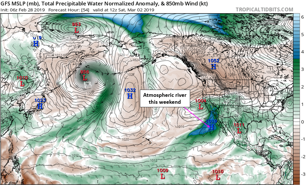
GFS moisture anomaly forecast for Saturday morning
This moisture combined with westerly flow will produce heavy snow in the High Country Thursday night into Sunday morning, with one to three feet of powder possible across Colorado’s mountains. Any day in the near-term should offer excellent ski conditions at virtually any of the resorts.
At the same time, a formidable 1054 mb Arctic high pressure system will drop south out of Canada into Montana and the Dakotas this weekend. This high could come within 10 millibars of the all-time sea-level pressure record for the continental United States (which is 1064 mb in Montana in 1983). The pressure only gets this high in the core of extremely cold airmasses during the winter! The forecast graphic below shows the pressure anomaly for Sunday morning.
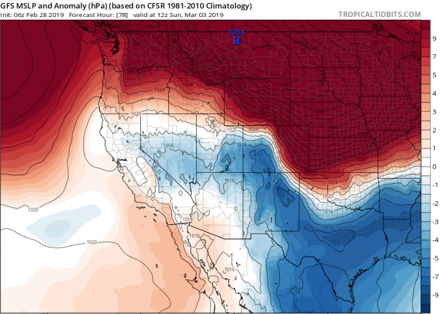
GFS sea-level pressure anomaly forecast for Sunday morning
But wait…doesn’t high pressure usually signify pleasant weather? In this case, it won’t for Colorado. Not only are we expecting possibly the coldest air so far this winter to overtake eastern Colorado, the “strong” clockwise flow around the high will bring upslope snow to the Front Range.
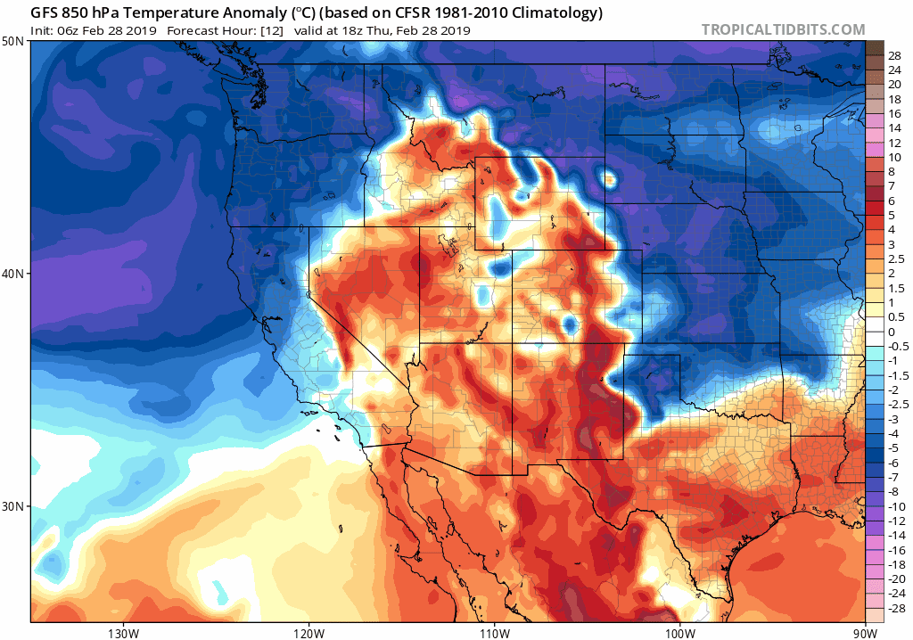
GFS 850 mb temperature anomaly animation through Monday night
Let’s step through this complicated forecast for the weekend…
FRIDAY: PLEASANT EARLY, CHANCE OF SNOW IN EVENING AND NIGHT
We’ll hang onto one last “seasonal” day before the preliminary cold front arrives to the Front Range by late afternoon or early evening. Highs will top out in the 40’s to lower 50’s. By evening, the nose of a 170 mph subtropical jet will enter the picture with moisture on the increase to the Mountains. In addition to the front, northern Colorado will be in the left exit region of this jet during the evening and overnight hours, and thus a few isolated rain or snow bands could clip the northern Metro area as a result.
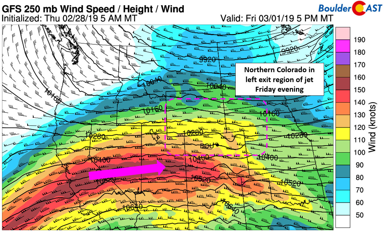
GFS 250 mb wind forecast for Friday evening
The best forcing Friday evening and night will end up north of the Metro area, with the region from Fort Collins to Cheyenne catching the brunt of the jet-forced snow. The GFS and European models generally paint this area with a broad brush of 2 to 5″ by Saturday morning. Given the banded nature of the snow, we think amounts will be considerably more variable.
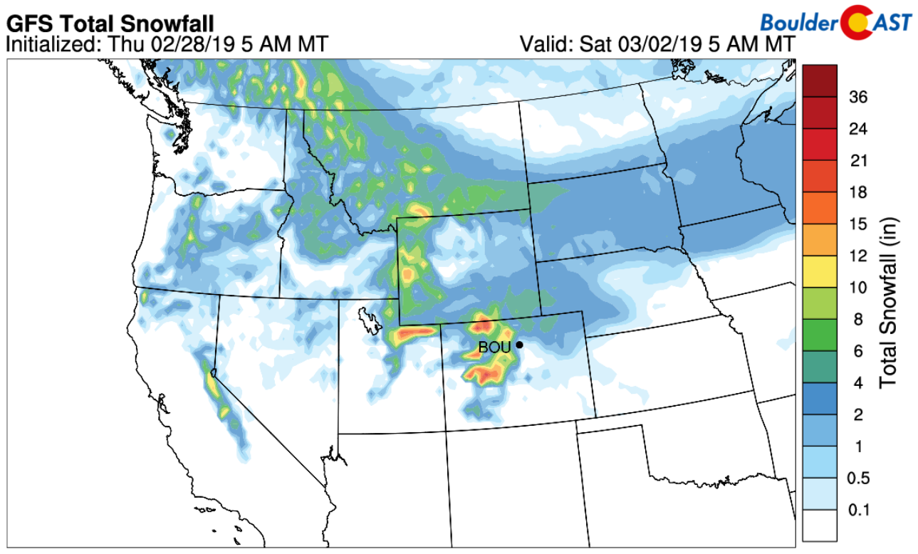
GFS model snowfall forecast through Saturday morning
As far as the immediate Denver and Boulder area, we’ll probably miss out on the action Friday night. We can’t rule out an isolated band or two putting down a quick inch of snow, but overall, most areas will likely see little to no accumulation.
SATURDAY: SNOW DEVELOPING, HEAVY AT TIMES
All the ingredients come together across Colorado on Saturday…..the remnant moisture from the atmospheric river, low-level upslope driven by the approaching Arctic high, and a mid-level storm system. These together will spell out widespread snow for the Front Range. Hooray!
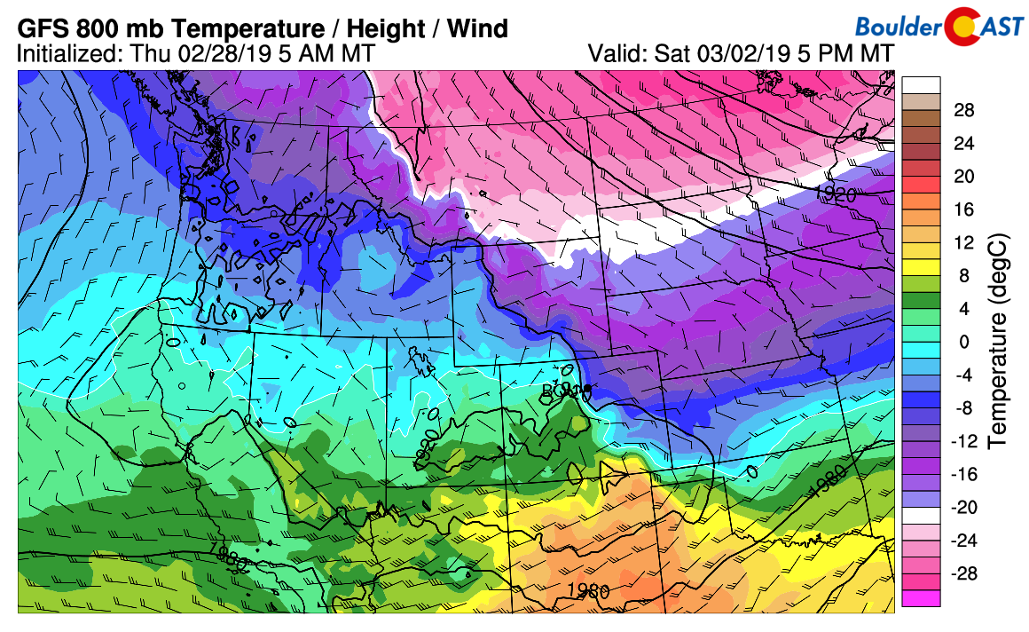
GFS 800 mb temperature and wind forecast for Saturday evening
Highs on Saturday will be in the upper 20’s to lower 30’s. Currently, the Arctic front is scheduled for around mid-day or early afternoon with snowfall breaking out for most of the Metro area around this time into the evening hours. Upslope and instability will be strongest Saturday afternoon and evening. We could see embedded moderate to heavy snow showers during this time. Shallow upslope will then keep light snow going into early Sunday morning. Models do not show the upslope growing too deep, generally remaining below 750 mb (8500 feet elevation). In these type of scenarios, areas near the interface of the Foothills/Plains tend to do best on snow amounts (i.e. Boulder, Golden, and Foothills below 8,000 feet). The one bad aspect is the duration….we’re only looking at about 12 to 18 hours of snow potential.
Our initial thoughts on snowfall amounts for Saturday afternoon into Sunday morning are as follows:
- Boulder area: 5-10″
- Denver area: 3-7″
- Foothills: 6-12″
As you can see, this event stands to be a fairly significant one for our region.
SUNDAY: A BITTER COLD DAY, LINGERING LIGHT SNOW
The bitter-cold Arctic airmass will be very much entrenched across Colorado under light easterly flow which will help keep very light snow going in the Metro area. Depending if we see some breaks in the clouds Sunday or not, highs may remain in the single digits across the lower elevations. Best case scenario? Lower to middle teens.
MONDAY: STILL COLD
With fresh snow and the potential for partially clearing skies, Monday morning could see temperatures drop below zero across the region. Highs will warm marginally back into the teens with a mix of clouds and sun.
We’ll continue to refine the forecast in the coming days. We’ll post an update with our official snowfall map sometime Friday evening or Saturday morning so check back then. For now, feel free to preemptively dust off those soup recipes!
P.S. It’s been a very cold February…
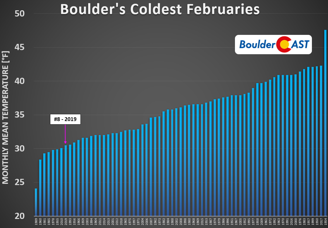
Coldest Februaries in Boulder since 1950
Spread the word! Share this forecast update:
.


You must be logged in to post a comment.