
A massive and complex storm is set to slam the entire western United States over the next several days. The Front Range will catch the bitter cold and snowy side of the storm with up to a foot of snowfall possible by Wednesday night alongside record-challenging frigid temperatures. We discuss the latest timing of things, just how cold it will get, the most likely snowfall amounts for the area, and the overall impacts expected from the looming winter storm.
Premium Storm Update (2/21/23 7:00PM): After a beautiful time in the 60s Tuesday, things are starting to look more stormy out there as the sun sets behind darkened clouds. It’s hard to believe, but snow will be falling in less than 12 hours in most areas with temperatures dropping into the single digits and teens in a flash! We run through a final check of the models looking at snow amounts, travel impacts and those cold temperatures. READ HERE
Bitter cold and more snow follow a beautiful Tuesday
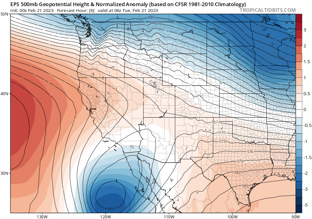
One heck of a storm is set to slam the entire western United States the next few days as an extremely anomalous trough digs southward from the Pacific Northwest and stalls over the central Rockies. From high winds, to big coastal waves, to heavy snow and bitter cold — this massive storm will bring it all the next few days! The Front Range will mainly catch the snowy and cold impacts from this event — a result of a remnant atmospheric river from the Pacific Ocean over-running a surge of Arctic air at the surface sourced from central Canada.
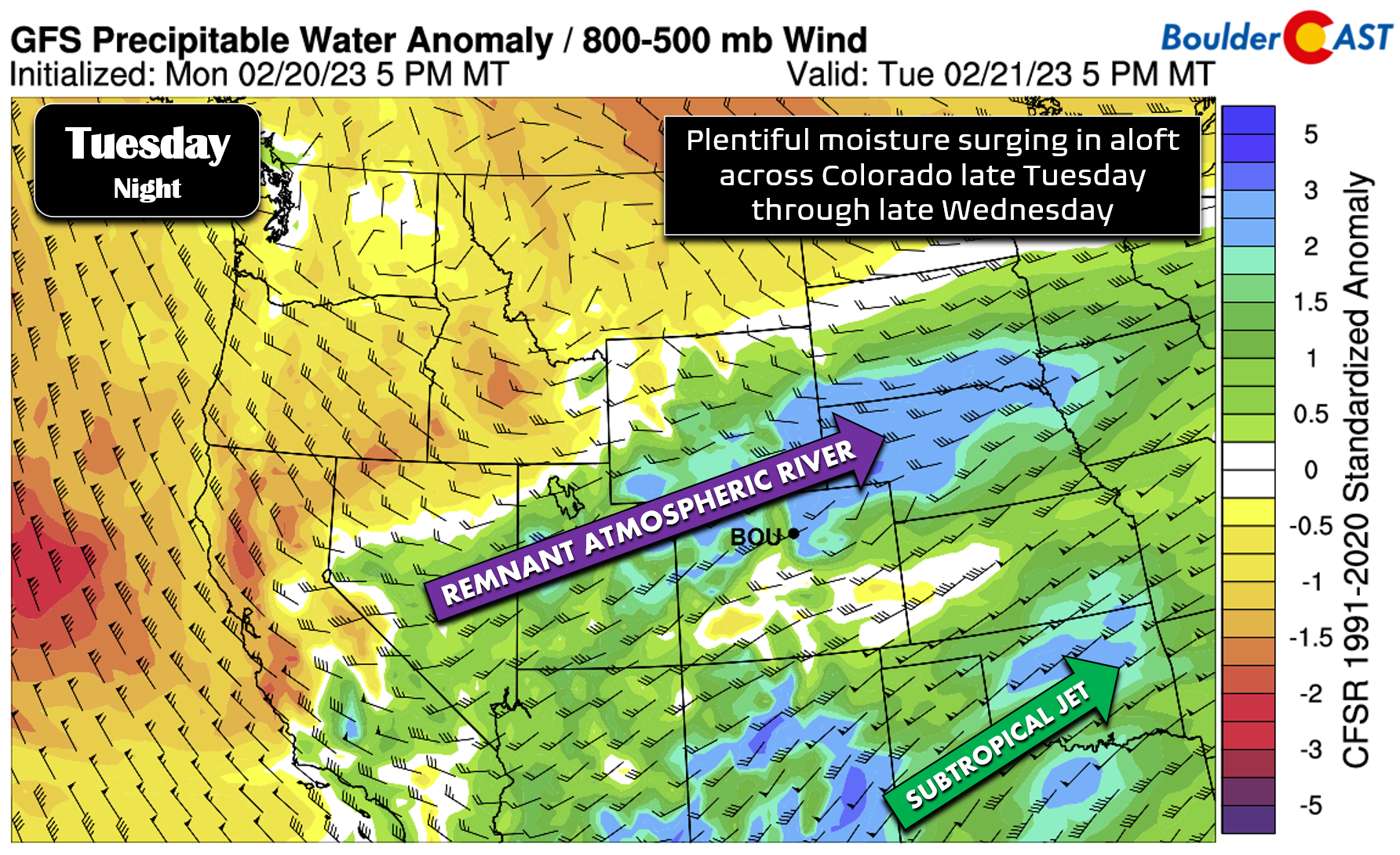
The GFS precipitable water anomaly forecast below identifies two players helping to supply moisture to the region for this event — 1) a remnant atmospheric river from the Pacific and 2) the subtropical jet stream. The ladder will mainly be a factor for heavy snow as the system kicks out into the upper Midwest Thursday and beyond. The former will mostly benefit our Mountains with orographics producing good powder over the next 48 hours for west and southwest facing slopes.
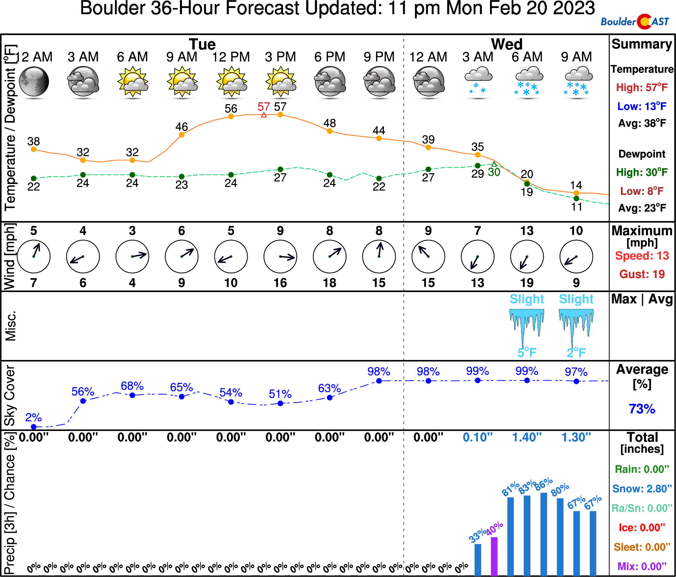
In the short-term, Tuesday will be a continuation of the “warm before the storm” with temperature soaring towards the 60-degree mark in the Metro area, with some spots in the heart of Denver pushing into the middle 60s. Gusty west-northwest winds will be around through the day, but it won’t be as windy as it was on Monday which was just brutal here in Boulder…

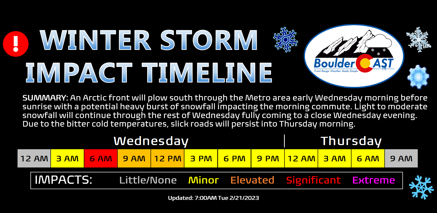
The aforementioned Arctic front will arrive early Wednesday morning under the cover of darkness. Current model trends bring the front into Boulder and Denver between 3 and 6AM on Wednesday. You’ll know when it arrives! Before the front, it will be a mild overnight in the 30s or even lower 40s across the area. After the front, temperatures immediately drop into the teens and single digits where they will remain the rest of Wednesday.

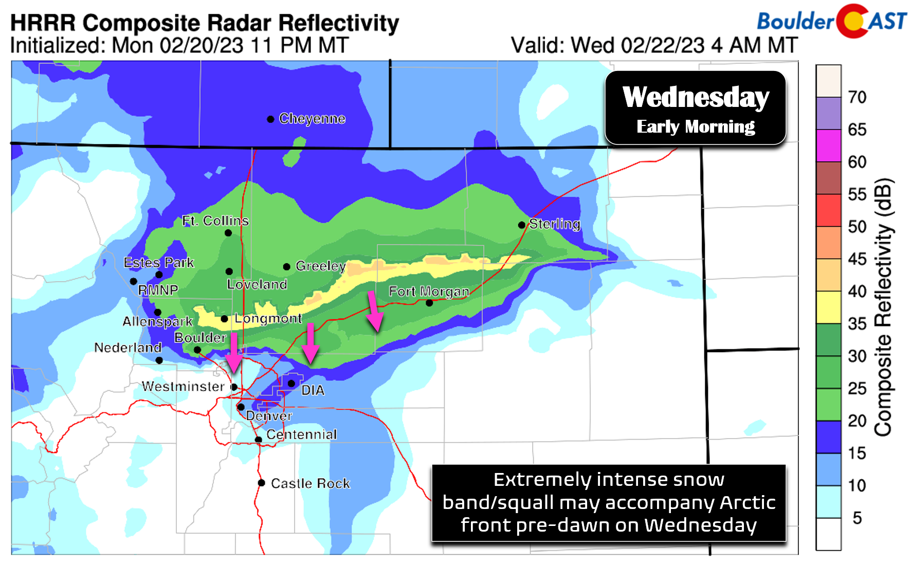
The initial blast of the Arctic front will provide intense lift aided by terrain interaction. High-resolution models are showing a very potent band of snowfall accompanying the front as it plows through the Denver Metro area early Wednesday. This band could easily have snowfall rates of 2 to 3″ per hour alongside gusty north winds creating whiteout conditions and dangerous travel in a hurry. Fortunately the timing looks to occur early enough that it shouldn’t hit smack in the middle of rush hour, but any delay in the front’s arrival could be a travel disaster for our area. You need to watch this situation closely if you have travel plans early Wednesday! Nonetheless, Wednesday’s morning commute will likely be icy and/or snowy for many of us!
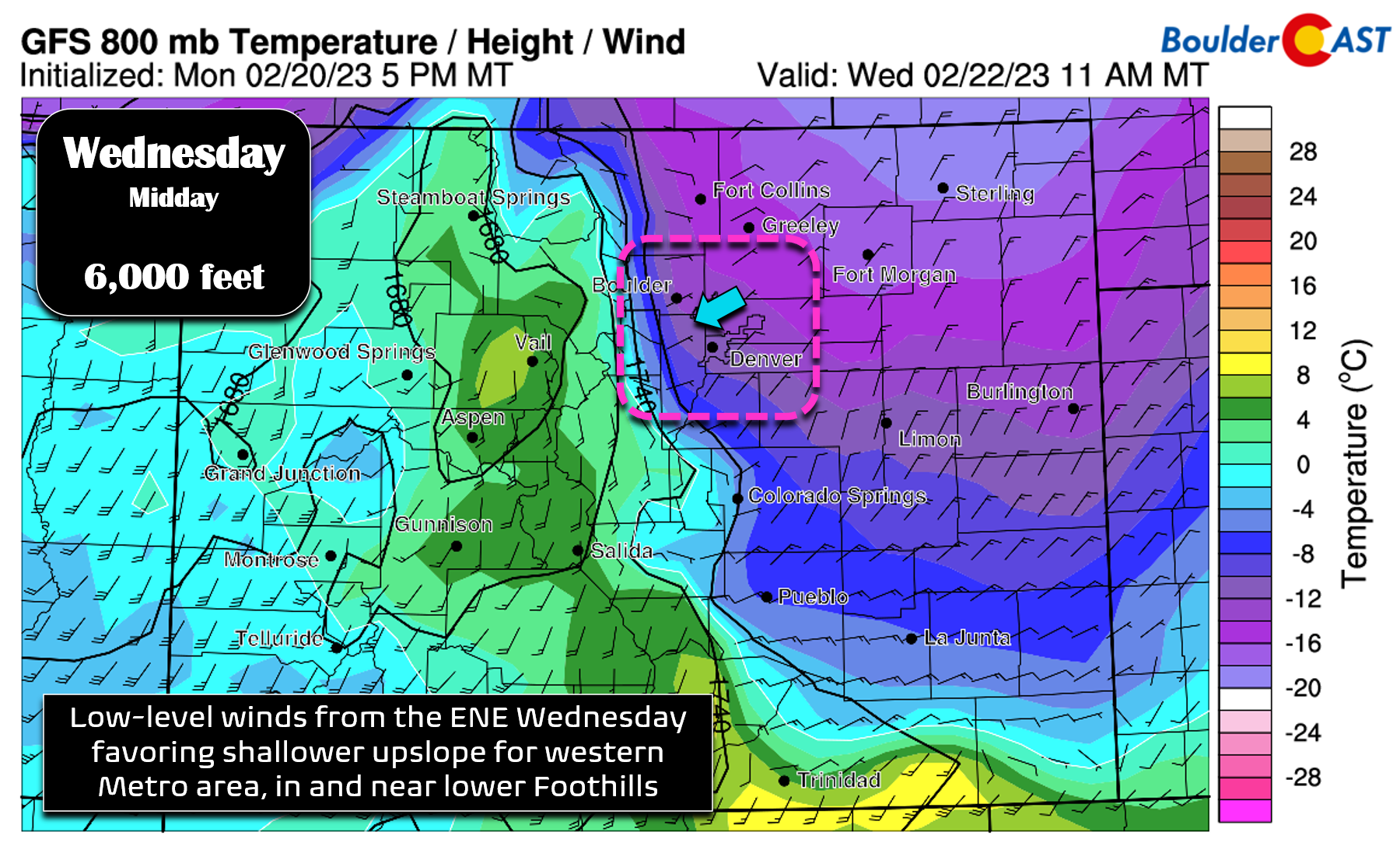
After the initial frontal surge, there will be a period of upslope-enhanced fluffy snowfall across the Front Range lasting most of the day Wednesday into the evening as temperatures plummet into the single digits. Here’s a look at the winds and temperatures at 6000 feet elevation on Wednesday. We see very healthy east-northeasterly upslope across the entire area, albeit it is on the weaker side (just 5-10 MPH).
However, moving up in the atmosphere to near 10,000 feet elevation things look much less favorable with predominantly southerly or southeasterly winds across the Front Range. This direction favors Larimer County. With the best and deepest upslope expected to stay closer to the Wyoming Border; that is also where the heaviest snow totals will likely be with this event.

Despite this, the combination of the burst of heavy snow in the morning and then the prolonged shallow upslope aided by some instability and jet-forcing will lead to a nice blanket of snow across the Front Range. This is yet another winter storm where Boulder and the lower Foothills will pile up the most snow due to the shallowness of the upslope and their slightly warmer temperatures. Snow ratios will tank a bit higher up given colder temperatures near or even below zero in the higher Foothills. Something similar happened earlier this winter season during an Arctic blast in mid-November.
Here’s a look at forecast snowfall totals from a recent GFS model run which targets portions of Boulder and Larimer County for the heaviest snow (close to a foot).

The HRRR model is more in-line with our thinking that the heaviest snow will land in Boulder and Larimer Counties between 5500 and 8000 feet elevation.

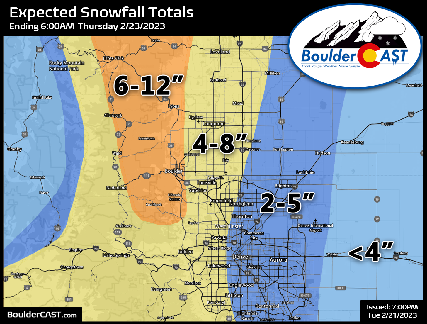
Our snowfall forecast map for the impending event is shown below, covering all snowflakes falling Wednesday morning into Wednesday night (map was updated 2/21/23 7PM). 6 to 12 inches snow is expected in and near the lower Foothills including in Boulder and Lyons. Elsewhere, 2 to 8 will fall with the highest totals west of Interstate 25 and closer to the Foothills.
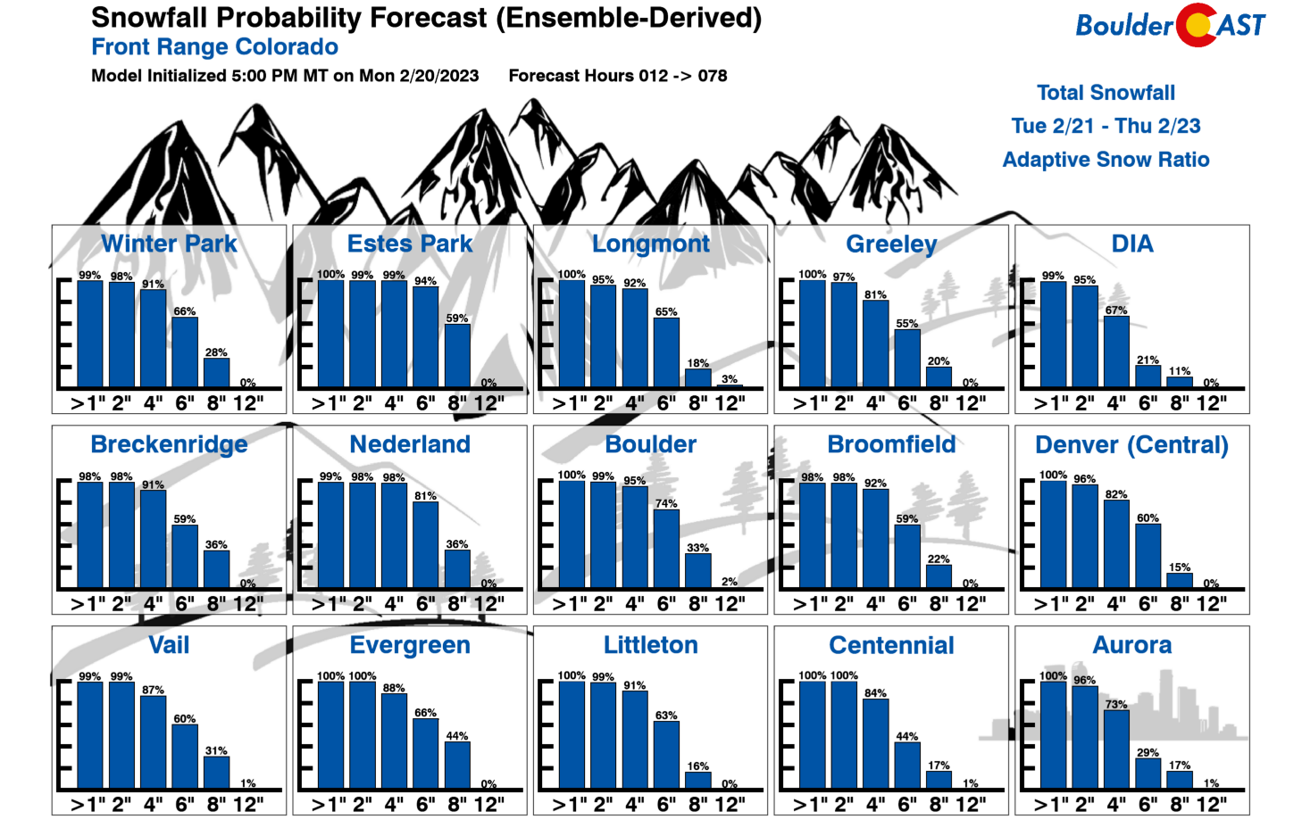
Our latest Snowfall Probabilities show that everyone has a great chance to see at least 2 to 6″ of snow. Boulder has a 33% chance of 8″ or more, while greater than 12″ is unlikely. As usual, DIA has the lowest odds of all snow amounts which made bode well for any airport go-ers on Wednesday…
There could be some brief rain showers or drizzle Tuesday night, but things really don’t get going until that front arrives early Wednesday morning at which point temperatures nosedive and snow then becomes the only possible precipitation type.
The greatest impact on travel will occur Wednesday morning, especially if the potential heavy snow band decides to hit in the middle of the commute window. Most guidance has the heaviest snow arriving before sunrise, but that’s not a given at this point. Bitter cold temperature and falling snow through all of Wednesday will keep travel slick and snow-packed making for cumbersome Wednesday evening and Thursday morning commutes as well.
As of writing, Winter Storm Warnings are posted for all of Boulder and Larimer Counties and along the Wyoming border. Winter Weather Advisories are posted for the rest of Denver and go into effect near or just after midnight Tuesday night.

If you are traveling elsewhere in the coming days, don’t overlook the fact that impacts from this ginormous winter storm will reach well beyond the borders of Colorado…

Finally, as snow comes to an end Wednesday night and skies begin to clear over the fresh snow cover, record-setting cold temperatures will be challenged across the Front Range. Boulder’s record low to beat on Thursday (February 23rd) is -5°F set back in the late 1800s. As long as the clouds dissipate as expected, this long-standing record will be in jeopardy. For those keeping track, this would equate to a roughly 70 degree temperature drop in the Denver area over the course of just about 39 hours (65°F 3PM Tuesday to -5°F 6AM Thursday! Thursday’s high temperature will only be in the teens to lower 20s at best. There’s a chance of getting above freezing on Friday, but odds are not looking overwhelming at the moment.

We’ll post one final discussion of the updated model data later today on BoulderCAST Premium. For now, feel free to take full advantage of the warmth on Tuesday ahead of the looming Arctic blast and snow!
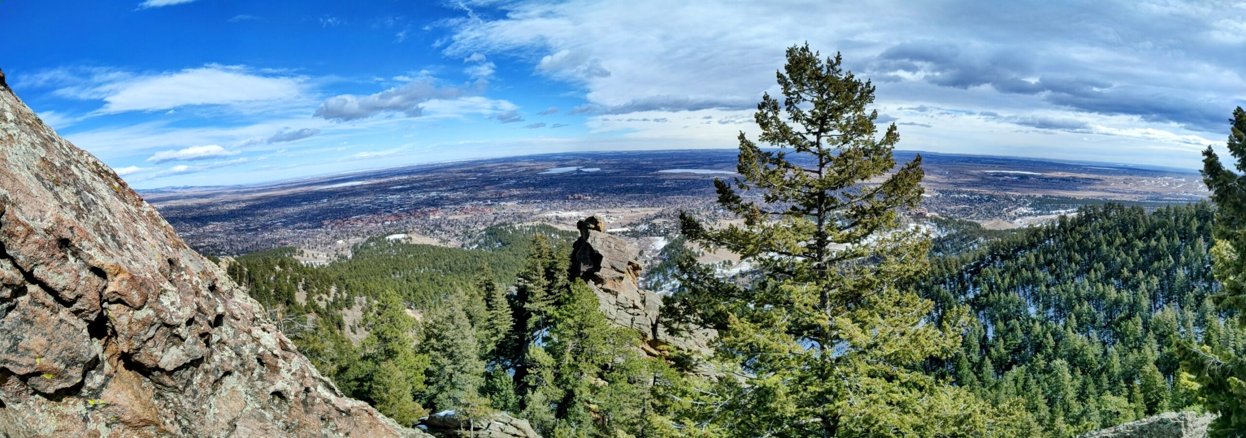
Photo overlooking Boulder from Monday afternoon (2/20/2023)
Get BoulderCAST updates delivered to your inbox:
Enjoy our content? Give it a share!


You must be logged in to post a comment.