Hold onto your hats, Colorado—today’s forecast isn’t just another breezy afternoon. A fast‑developing mountain wave event is lining up to deliver some of the strongest winds we’ve seen in quite some time, with Boulder squarely in the bullseye for this event. We’re talking winds that can go from calm to extreme in minutes, near-critical fire danger with every gust, and even the likelihood of planned and unplanned power outages. Add in mountain snow squalls and a sharp cold front tonight, and it’s definitely a busy day in Colorado weather. Read on for the full breakdown of timing, impacts, and what you need to know to stay safe as the event unfolds.
What You Need to Know
- 🌬️ Extreme Winds: Downslope winds ramp up late morning, peaking during the afternoon at 70–90 MPH in Boulder/foothills, 45–70 MPH as far east as I‑25. Winds begin to relax by early evening.
- 🕒 Timing: Boulder hit hardest between 12PM-6PM, Denver 3-5PM
- ⚡ Power Outages: ~50,000 Xcel customers in mainly Boulder/Jefferson Counties will be shutoff beginning at 10AM (for unknown duration). Scattered unplanned power outages expected elsewhere in Metro area.
- 🌲 Other Impacts/Risks: Downed trees, toppled fences, tractor trailers tipped, blowing dust and tumbleweeds across the Plains.
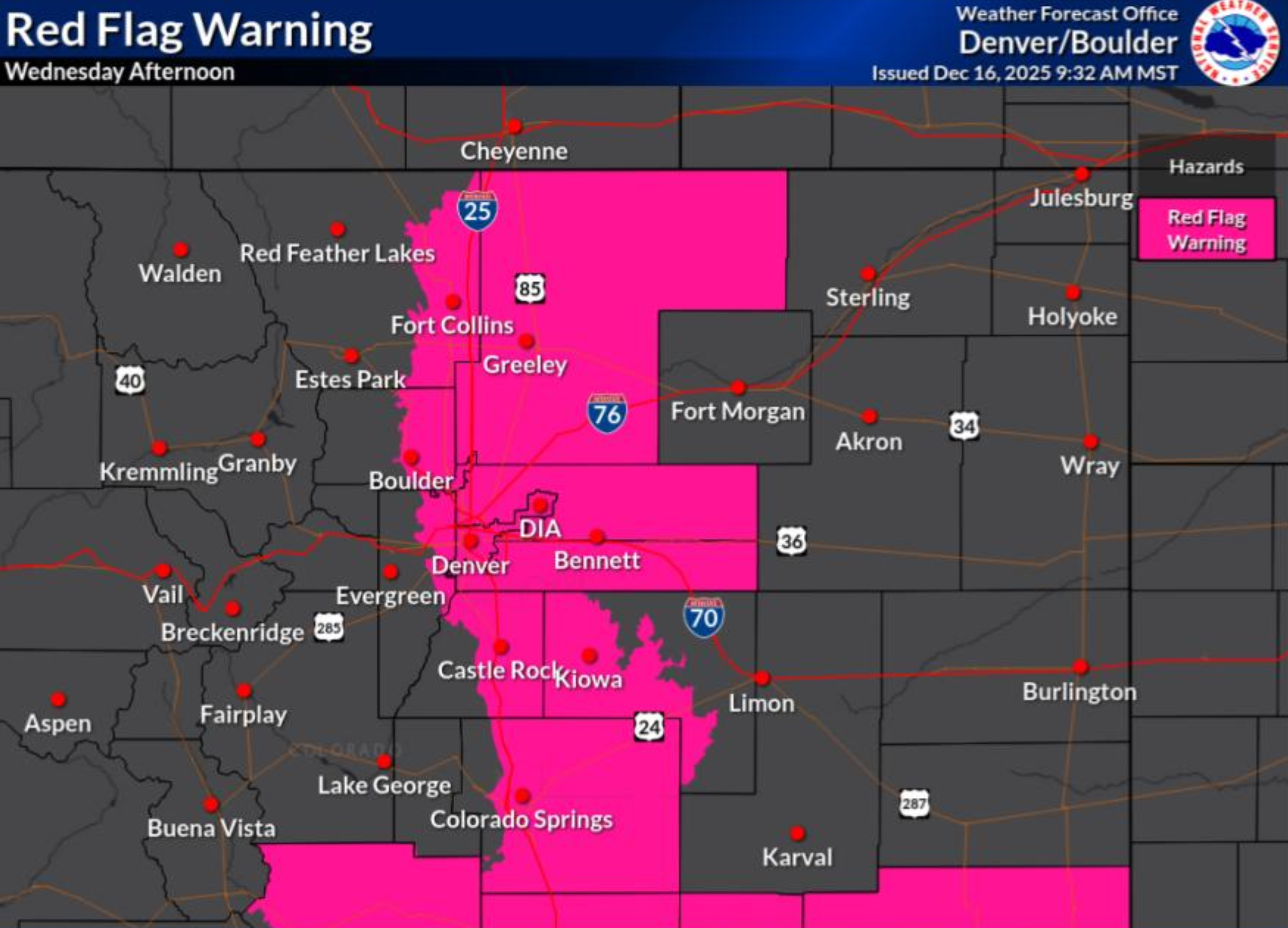
- 🔥 Fire Danger: Red Flag Warnings 11 AM–6 PM below 6000 ft; near‑critical fire risk with dry fuels and extreme gusts.
- ❄️ Mountain Snow: Jet‑forced bands may drop up to 6″ north of Indian Peaks into RMNP; blizzard‑like travel conditions this evening and tonight.
- ♻️ Another Windstorm Friday? We’re already tracking another potential high wind event for Friday which could have similar impacts, though it’s still not certain.

Go Premium, get all the perks.
Daily Forecast Updates
Get our daily forecast discussion every morning delivered to your inbox.
All Our Model Data
Access to all our Colorado-centric high-resolution weather model graphics. Seriously — every one!
Ski & Hiking Forecasts
6-day forecasts for all the Colorado ski resorts, plus more than 120 hiking trails, including every 14er.
Smoke Forecasts
Wildfire smoke concentration predictions up to 72 hours into the future.
Exclusive Content
Weekend outlooks every Thursday, bonus storm updates, historical data and much more!
No Advertisements
Enjoy ad-free viewing on the entire site.
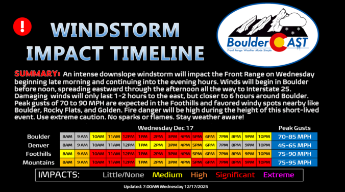
Damaging winds begin late morning to early afternoon
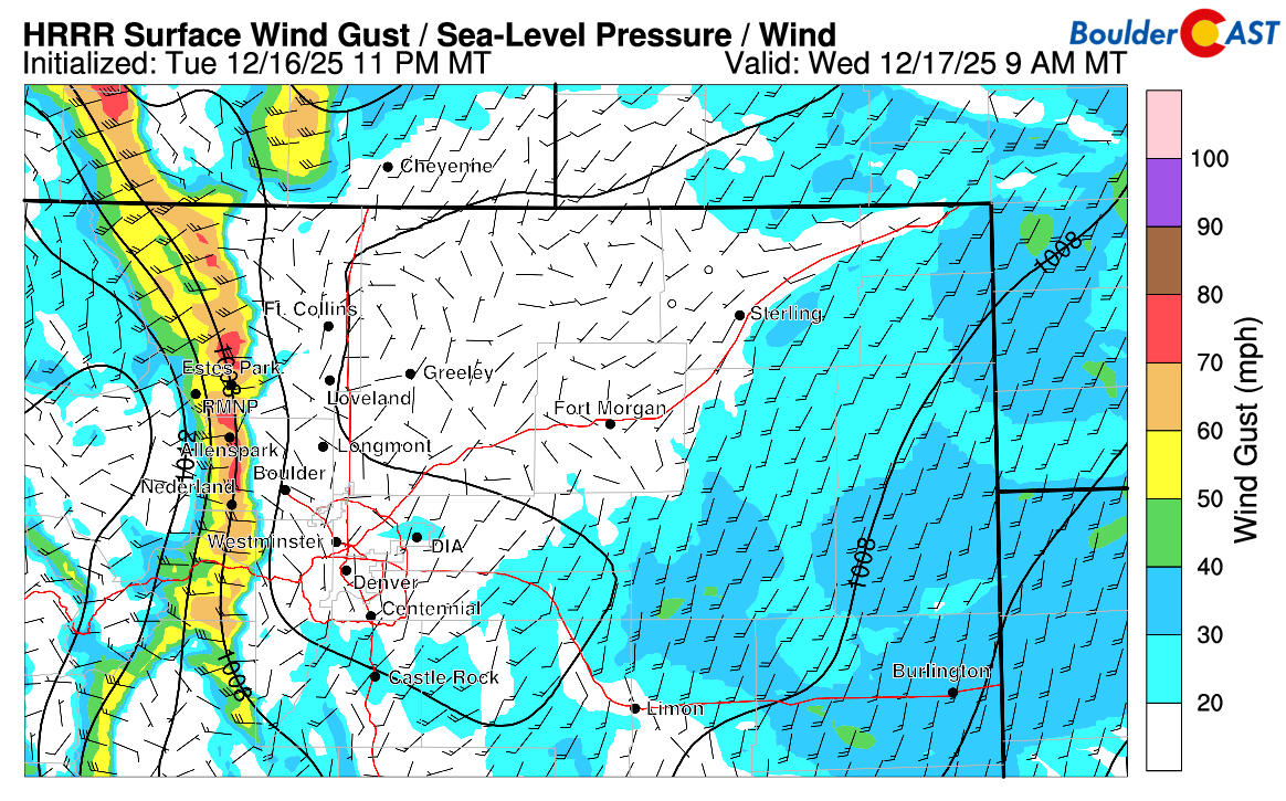
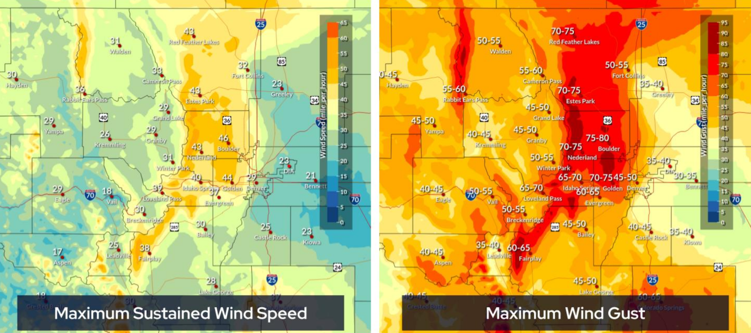
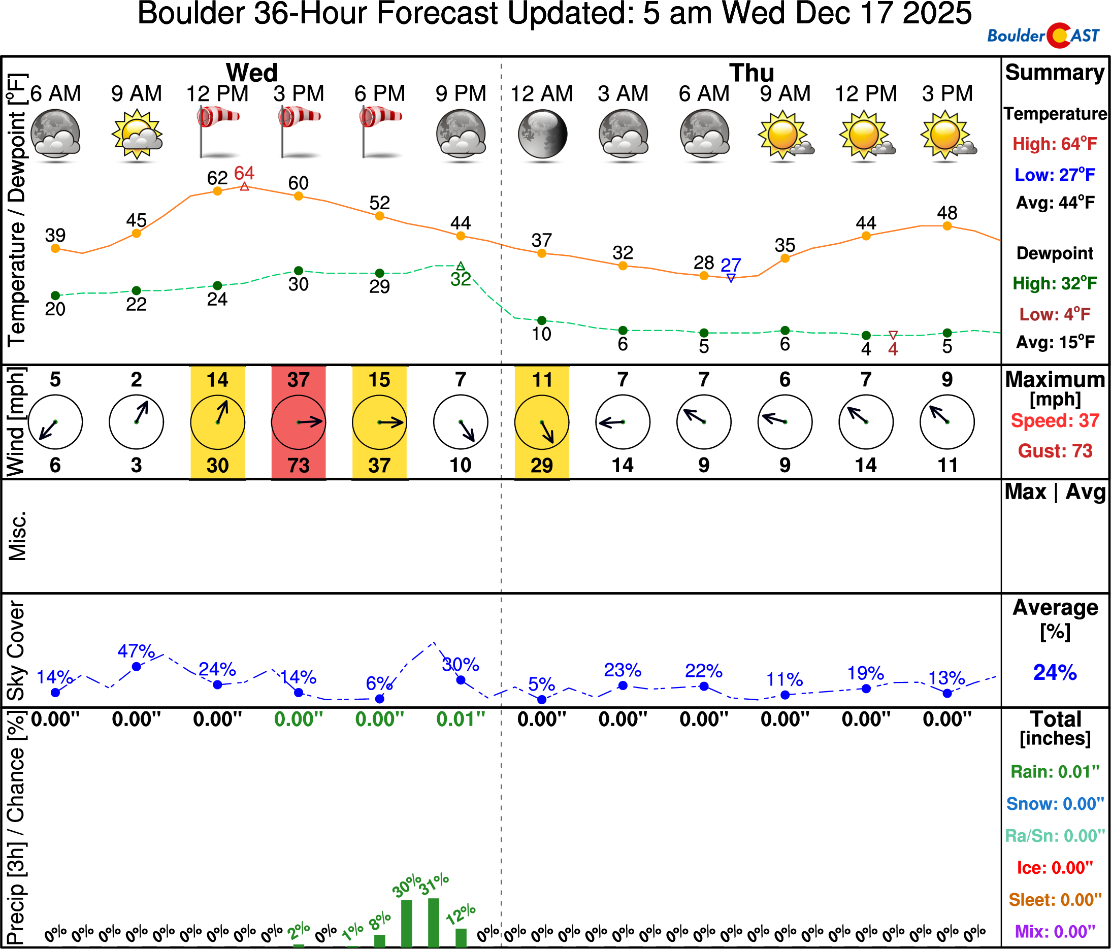
Model guidance continues to line up on a widespread but short-lived high‑impact windstorm today, beginning around midday and lasting into the early evening. The setup features a strong mountain wave: as air rushes over the Rockies, it accelerates down the eastern slopes of the Front Range. By late morning, conditions will come together quickly, sending a surge of powerful downslope winds into the Denver Metro area. Boulder will be one of the first—and hardest hit—locations, with winds potentially ramping from calm to extreme in just minutes sometime between about 10 AM and 1 PM.
Once the winds get going, they’ll spread eastward through the afternoon. Damaging gusts over 55 MPH are expected to reach as far as Interstate 25. East of I‑25, the strongest winds will fade quickly, but Boulder will see a much longer window—roughly six hours—of damaging wind potential compared to just one or two hours farther east.
 Peak Wind Gusts
- Foothills and wind‑prone spots (Boulder, Rocky Flats, Broomfield Airport, west Arvada): Peak gusts of 70–90 MPH are likely.
- Metro corridor near I‑25: Gusts of 45–70 MPH expected.
- Farther east (DIA, Aurora, Parker): Winds drop off quickly, mostly 30–40 MPH or less.
Probability of a least one wind gust exceeding various thresholds within 5 miles of BOULDER:
- 60 MPH: 100%
- 70 MPH: 85%
- 80 MPH: 70%
- 90 MPH: 25%
- 100 MPH: 5%
Probability of a least one wind gust exceeding various thresholds within 5 miles of DENVER:
- 60 MPH: 70%
- 70 MPH: 20%
- 80 MPH: 10%
- 90 MPH: < 1%
- 100 MPH: 0%
Expected Impact Timing
- Scattered unplanned power outages
- Lots of downed trees and/or tree limbs
- Flattened suburban fences
- Blowing dust (mainly east of Denver)
- Tumble weed activity
Expect the most disruptive winds during the late morning through early evening. These events rarely follow the clock exactly, but the cold front arriving tonight will shut down the mountain wave and bring somewhat calmer conditions (but still blustery). Denver should quiet down by 5–6 PM, with Boulder following an hour or two later. The graphic below highlights the periods to watch for peak winds today when most of the impacts will occur. Use this as an approximation, not a hard timeline due to uncertainties.

Fire Danger Peaks with the Wind
The other big concern today is fire risk. Even though humidity will hover between 15–25%, the extreme winds combined with dry fuels (no precipitation since the snowstorm two weeks ago) will push fire danger to near‑critical levels.
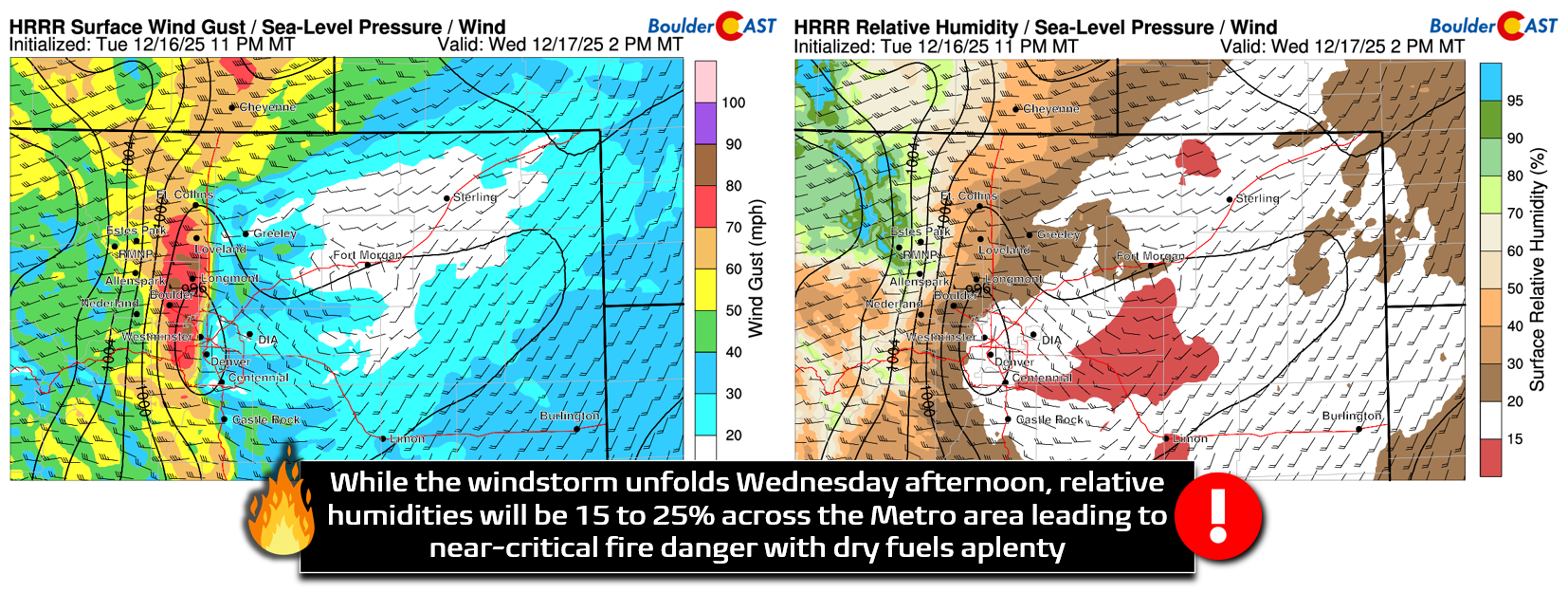
Red Flag Warnings are in effect from 11 AM to 6 PM below 6000 feet elevation. This covers a huge area: Fort Collins, Longmont, Boulder, Denver and suburbs, DIA, Castle Rock, Colorado Springs, and Pueblo. With millions of people across more than a dozen counties, the hope is for no new ignitions—but that’s a tall order.
Xcel Energy Shutoffs
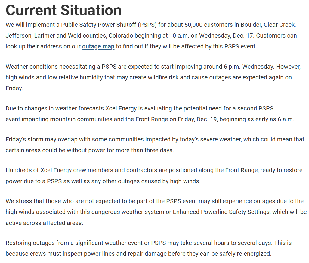
Xcel Energy will be doing their (controversial) part today by de-energizing many communities in the western Metro area which are forecast to have the strongest downslope winds. The planned shutoff will begin at 10AM and will impact the shaded areas below, which is about 50,000 customers Xcel says. You can verify whether your address is affected over on the Xcel Outage page. Plan for power to be shut off at least until 6PM, but it will likely be longer in some areas, perhaps pushing well into Thursday or later. Xcel has to have time to access and repair your grid sector before power will be restored. Depending on the extent of any damage, this could take a while.
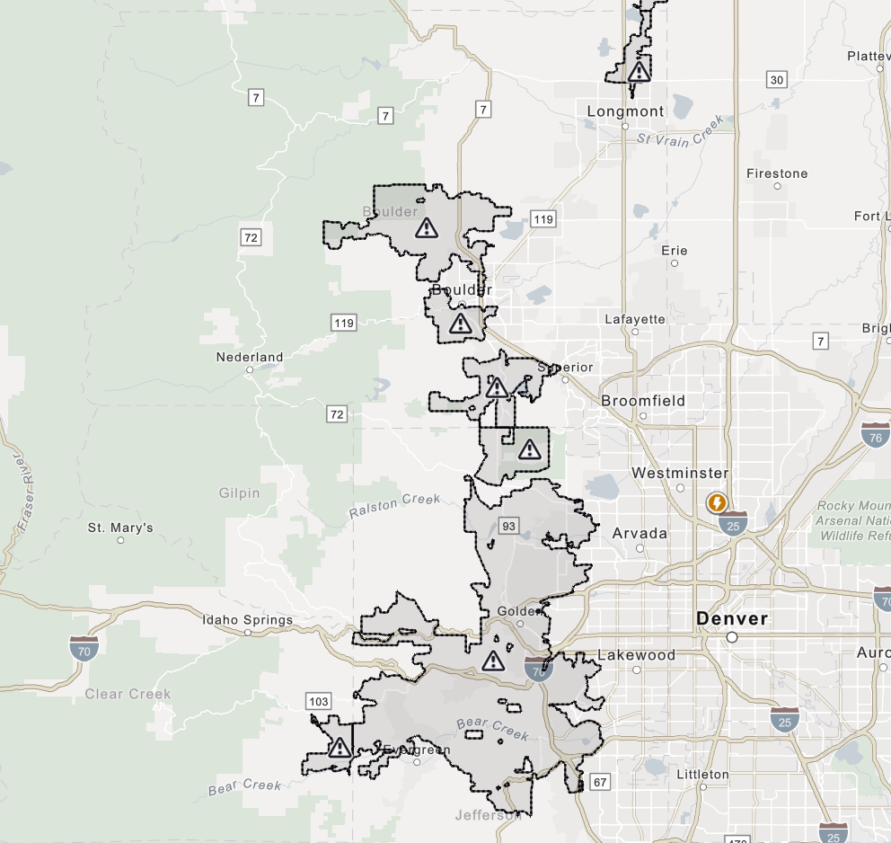
Xcel shutdown map for the Denver Metro area.
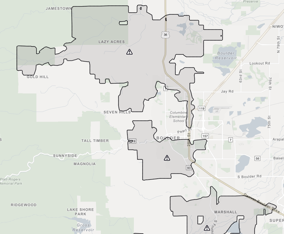
Potential Xcel shutdown map for the Boulder area (updated Tuesday evening). This may not be the final map.
Xcel is also already advertising another potential shutoff event on Friday, with potentially some customers remaining completely without power for 3+ days. The latest information from the Xcel website for today’s event and how Friday’s shutoff may go is included below.
Mountain Snow and Metro Showers
Meanwhile, the mountains will see several inches of snow as the trough and moisture pulse move through this afternoon and evening. Jet‑driven snow bands could dump over an inch per hour along and west of the Divide, creating blizzard‑like conditions with 90 MPH wind gusts thrown into the mix. Travel into the High Country tonight is strongly discouraged, especially around Rocky Mountain National Park and into the Park Range near Steamboat.
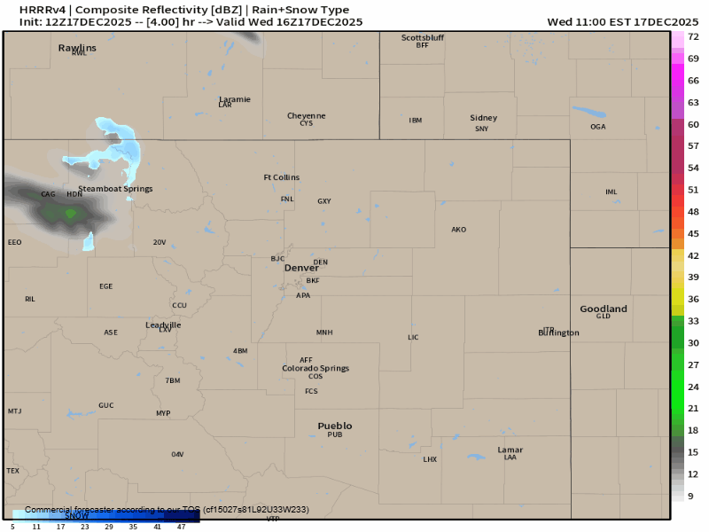
Some rain/snow showers will drop across the lower elevations as well alongside the evening cold front, but they will be fighting the downslope winds and thus will be unimpressive and spotty. Showers will mainly be in the form of rain, but some snowflakes could mix in late in the evening if any showers remain. The primary window for quick a raindrop or snowflake is from 5 to 10PM during the evening.
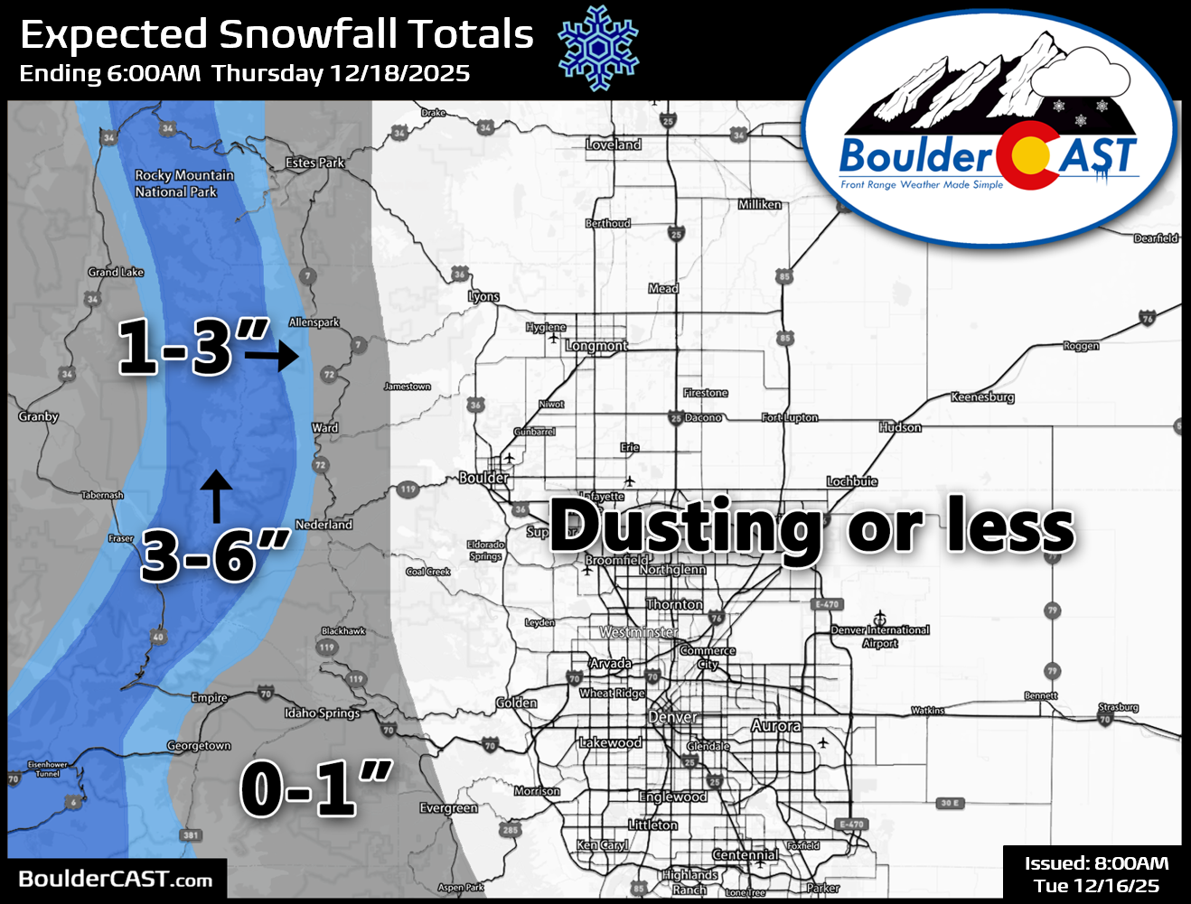
Our snowfall forecast map remains unchanged, with generally 3 to 6 inches expected in the high Mountains, and basically nothing sticking or falling to the east.
Outside of the extreme windstorm, high fire danger, chance of showers this evening and the Mountain snow squalls, today will be pretty nice for the area with highs reaching the middle 60s in Boulder and Denver. Thanks to the cold front, Thursday will be colder, topping out in the upper 40s. Unfortunately it looks like we are going to see another strong windstorm on Friday, but there’s lots of uncertainty regarding intensity and how far east those winds may reach.
Wrap-up
Secure anything that can blow around, expect power disruptions, and absolutely avoid outdoor activities that could spark a fire. The Boulder area and Foothills will bear the brunt of this event, but impacts will ripple across the Front Range. Stay safe, and let’s hope the storm comes in on the lower end of model forecasts and we can avoid any new fire starts.
Spread the word, share our crazy Colorado weather:
Go Premium, get all the perks.
Daily Forecast Updates
Get our daily forecast discussion every morning delivered to your inbox.
All Our Model Data
Access to all our Colorado-centric high-resolution weather model graphics. Seriously — every one!
Ski & Hiking Forecasts
6-day forecasts for all the Colorado ski resorts, plus more than 120 hiking trails, including every 14er.
Smoke Forecasts
Wildfire smoke concentration predictions up to 72 hours into the future.
Exclusive Content
Weekend outlooks every Thursday, bonus storm updates, historical data and much more!
No Advertisements
Enjoy ad-free viewing on the entire site.


You must be logged in to post a comment.