The Pineapple Express was back at it again this past weekend. Another round of soaking rain struck California, with all that tropical moisture translating into heavy mountain snow across northern Colorado.
The atmospheric river (AR) event this past weekend produced significant precipitation from California into the Pacific Northwest, all the way to the mountains of Colorado. Yes big rain and snow totals were observed, but 2 to 6″ of precipitation is far from historic by AR standards.
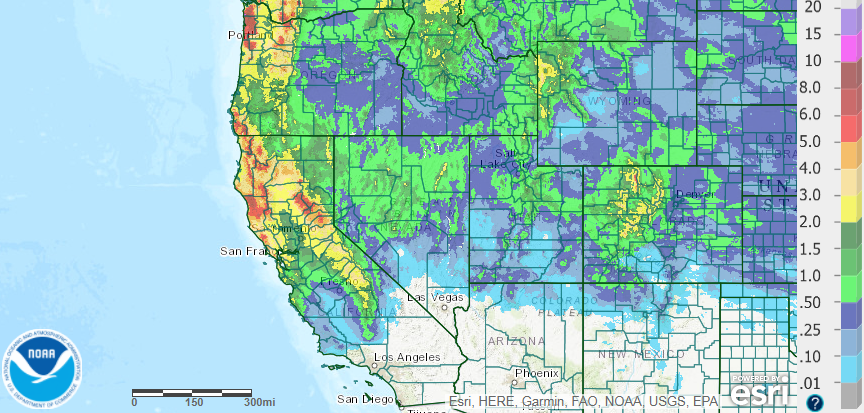
Precipitation totals from the atmospheric river event – April 5-8, 2018 (Source: NOAA)
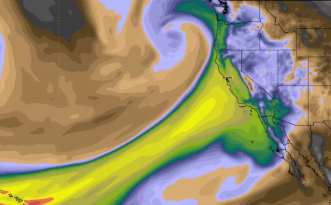
However, when considering just the absolute moisture content in the air (i.e. precipitable water), the event was one of the most significant to impact California and the southwestern United States ever measured. The animation below shows the GFS moisture anomaly for the time period of April 5-8, 2018. The surge of tropical moisture into California is obvious. The very white-ish blue colors in the core of the AR indicate moisture content was more than six standard deviations above normal, and over a huge area!
GFS forecast for moisture anomaly from April 5-8 2018 (Source: Tropical Tidbits)
If the moisture content was so historic, why were precipitation totals not more extreme? Moisture is only one piece of the puzzle that goes into an AR. Just like here in Colorado, both low-level wind speed and direction are important as the tropical moisture comes ashore and collides with the steep terrain in California. The faster the winds and the more direct the flow is into the terrain, the more moisture that can be “squeezed” out of the atmosphere. This particular AR event was non-ideal from a dynamical perspective. That is, the winds were weaker which limited the overall efficiency of the river.
Despite reports of three feet of snow in the higher Sierras, a significant amount of moisture made it into Colorado as well over the weekend. Saturday evening’s weather balloon launch in Grand Junction turned-up a precipitable water value of 0.90″. This set a new all-time record for the month of April…by a HUGE margin. Remember that precipitable water is just a fancy term for how deep the layer of water would be if you condensed all the moisture out of the entire atmosphere above. We have added Saturday’s measurement to the climatology of precipitable water below (green star). The noisy red line is the historical maximum moisture value for each day of the year.
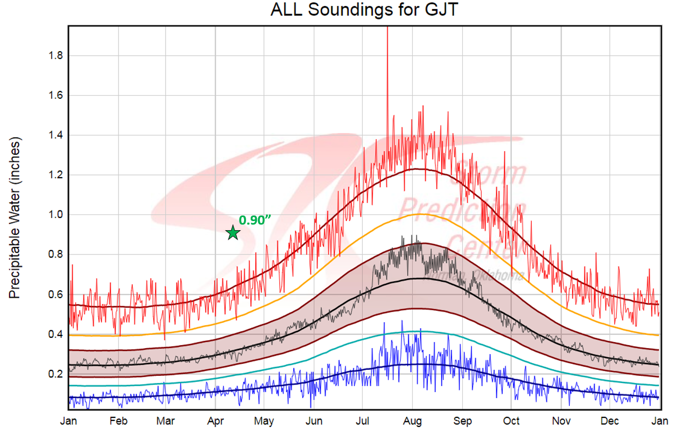
Grand Junction, CO climatology of precipitable water measurements taken from historical radiosondes. (Source: NOAA Storm Prediction Center). April 7 2018 measurement of 0.90″ is shown by a green star.
The moisture plume also made it into the Metro area. Denver’s weather balloon measured 0.57″ of atmospheric moisture overhead Saturday evening. This literally came within a millimeter of the daily record (see below), but wasn’t nearly as extraordinary as western Colorado’s moisture.
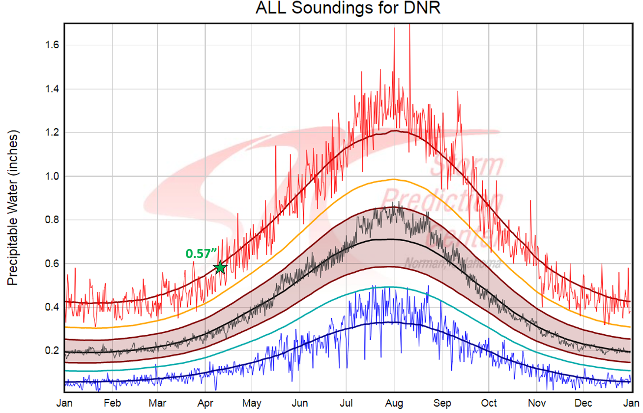
Denver, CO climatology of precipitable water measurements taken from historical radiosondes. (Source: NOAA Storm Prediction Center). April 7 2018 measurement of 0.57″ is shown by a green star.
While this moisture brought only a few sprinkles of rain to Boulder and Denver, the higher northern Mountains saw their biggest snows of the year during this time. Here are some of the ski resort snow reports from over the weekend:
- Copper – 36″
- Breckenridge – 33″
- Winter Park – 32″
- Loveland – 31″
- A-Basin – 25″
- Aspen – 19″
- Vail – 17″
These 1 to 3 foot snow totals are remarkable given how warm the air was within the moisture-laden atmospheric river. Snow levels were generally above 11,000 feet for most of the event. This definitely was not champagne powder. It was a water-rich sludge with a low snow-to-liquid ratio. If you decided to go skiing after or during this recent dumping, I’d wager you didn’t enjoy it as much as you expected to!
The weather models actually did a great job forecasting the heavy mountain snow, despite their bias to typically overestimate snowfall when warm and moist southwest flow descends on our region. This event once again mainly benefited the northern half of the state, with snowpack across southern Colorado remaining worryingly low….
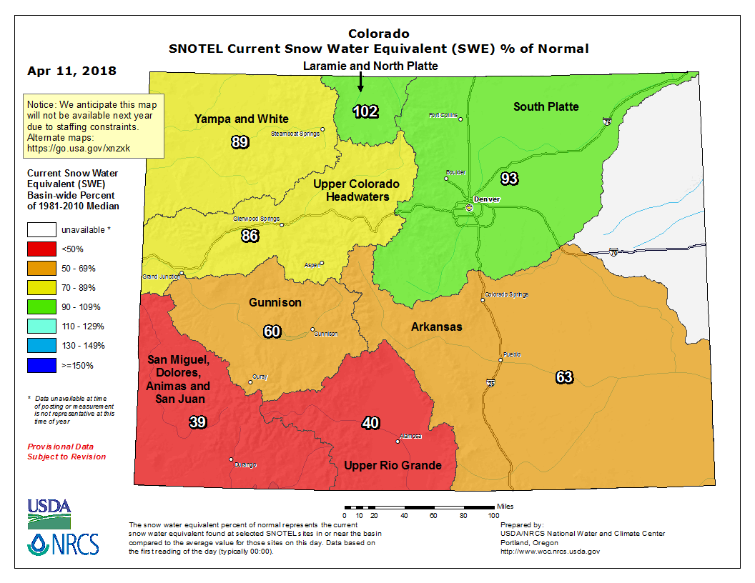
Current snowpack across the river basins of Colorado in terms of percent of normal snow water equivalent for this time of year.
The “season” for these AR events is behind us now. In fact, this past weekend’s AR was already way late to the party. We’ll need to rely on the typically active April and May storm track to deliver precipitation as we move through the rest of spring.
FYI: UC-San Diego has a great site for forecasting and monitoring AR events before and as they happen. Check it out!
SHARE THIS POST:
.


You must be logged in to post a comment.