Models have stuck to their guns overnight and our confidence has increased that a widespread, significant winter storm will impact the Front Range Friday into Saturday. This system could produce more than 2″ of much-needed moisture across the area. Unfortunately, a good chunk of this will be falling in the form of heavy wet snow which will have damaging impacts across the area from downed trees and power outages. Sub-freezing temperatures are also expected to impact sensitive plants. Here’s the latest on the storm, including how much snow to expect, how cold it will get, and a few ideas to prepare for this late-season taste of winter!
We discuss Boulder and Denver weather every single day on BoulderCAST Premium. Sign up today to get access to our daily forecast discussions every morning, complete six-day skiing and hiking forecasts powered by machine learning, access to all our Front Range specific weather models, additional storm updates and much more!

T
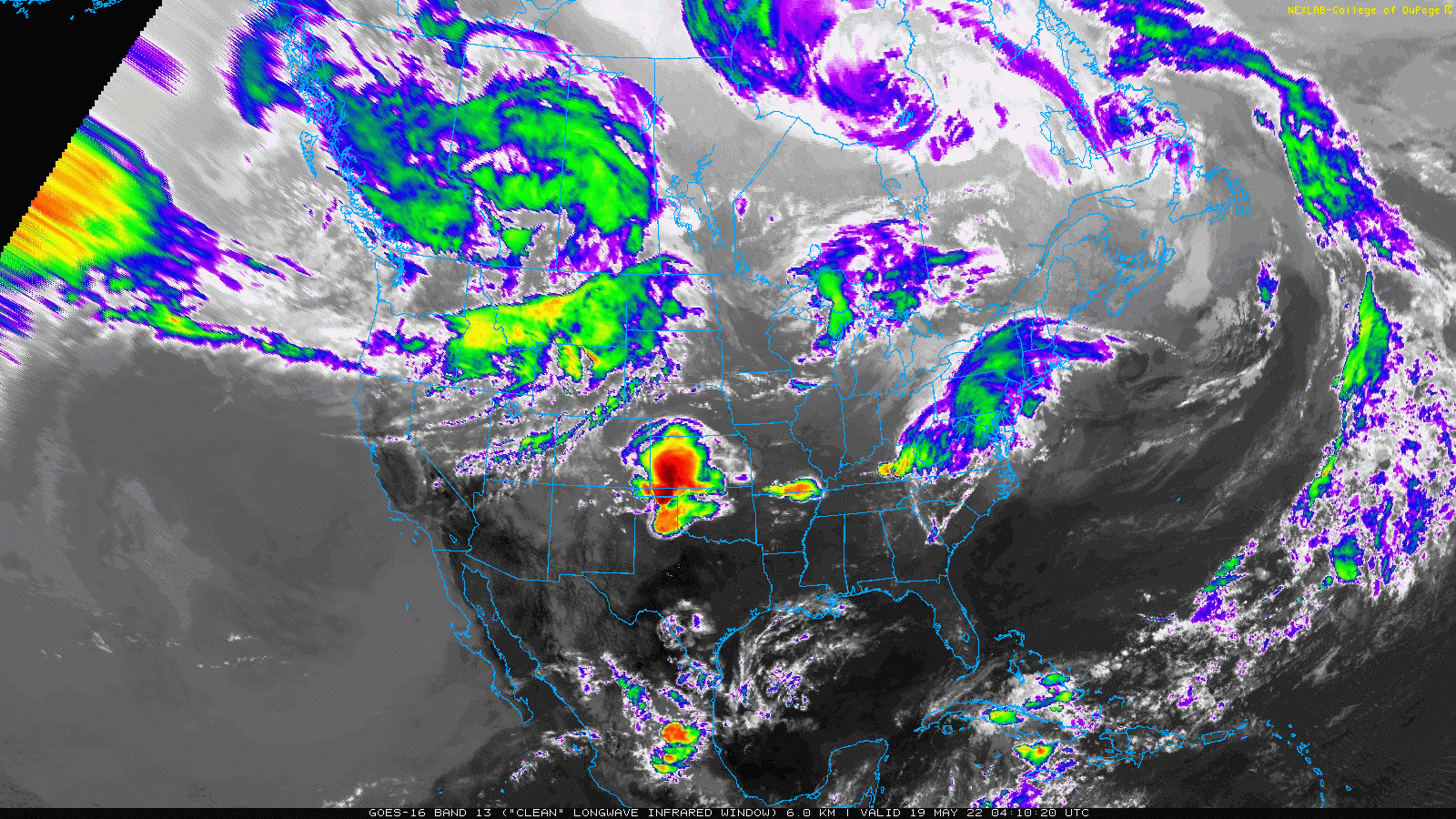
he general trend over the last day or two has been for a colder and stronger storm overall, thus leading to slightly higher predicted snowfall totals across the board for the Front Range. Our storm is gaining strength along the Canadian border early on this Thursday morning. It will spread southward into Colorado Thursday night and be with us into Saturday leading to an extended period of unsettled and cold weather. The incoming storm system looks rather foreboding from space this morning — check out the well-defined spinning low pressure in western Canada in the animation below.
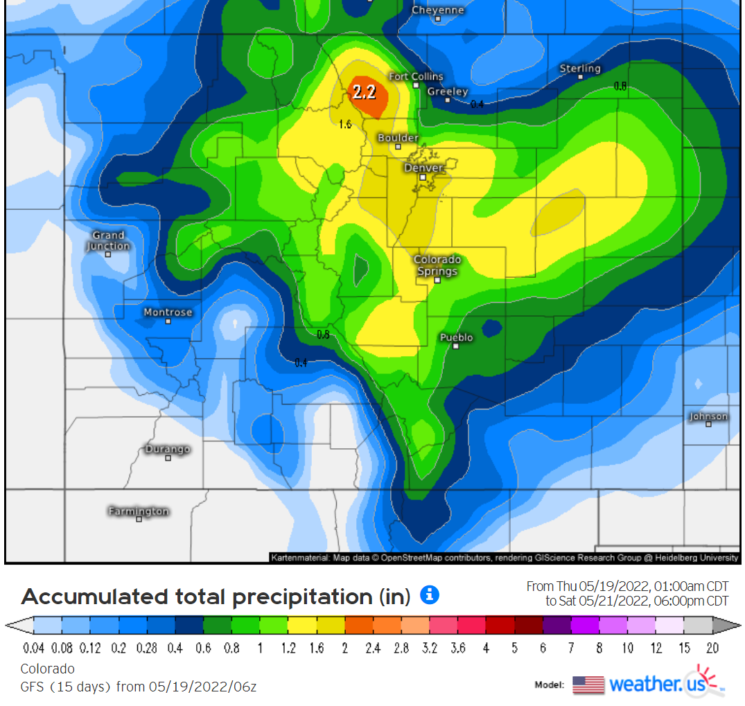
Essentially all of the available weather models have doubled down on what is shaping up to be a major moisture dump for our area over the next 48 hours. The latest GFS ensemble suite looks impressive for late May, or really any time of year. This model’s 30 runs are now closely clustered around 2″ of moisture in Boulder with this event. This is great — we’ll take all the moisture we can get! The bad news is that much of this will be falling in the form of wet snow which could have very real impacts on the vegetation and power grid.
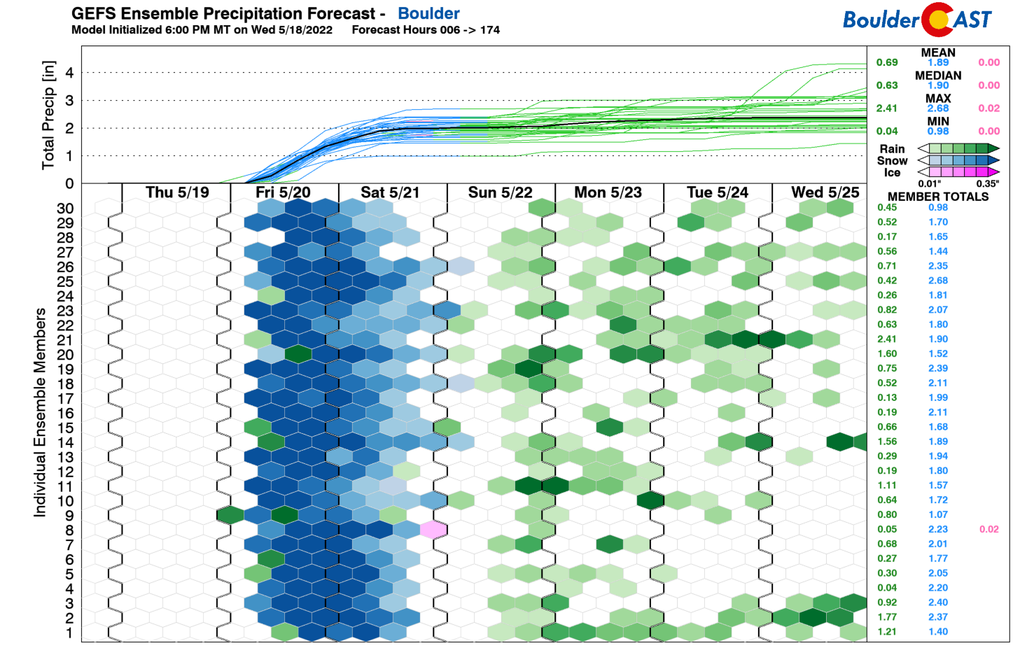
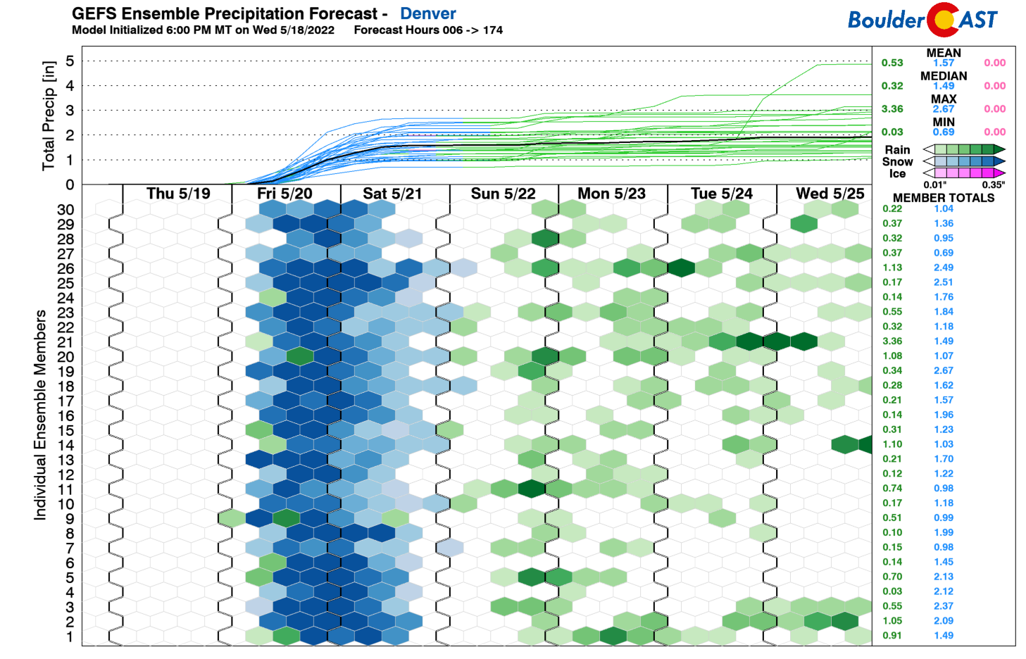
The same model suite is much less clear for Denver with a median value of around 1.5″ but much more spread. This is typical though, as Denver usually sees less precipitation (rain or snow) from these type of events.
Here’s what this looks like spatially across Colorado from the single operational GFS run. Yikes — that’s a big 1 to 2″ bullseye right over the Front Range!
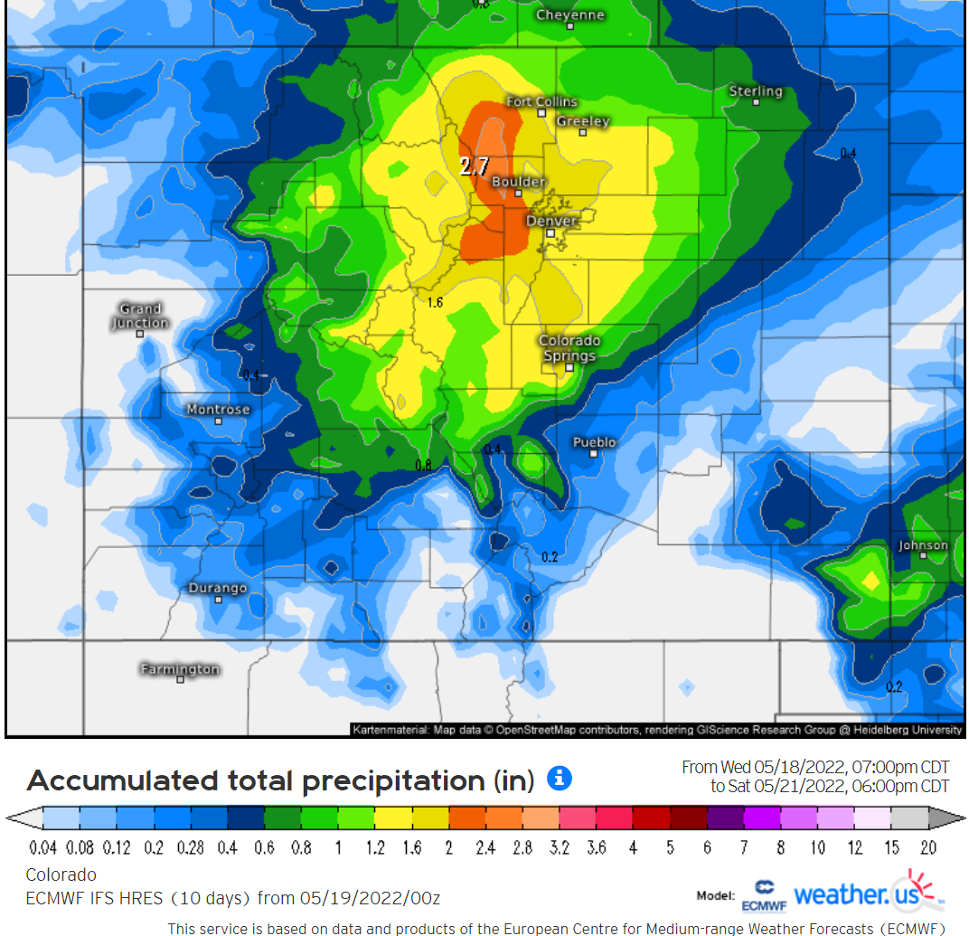
The Euro model is very similar overall, but the target is even more squarely aimed at Boulder County with amounts up to 3″.
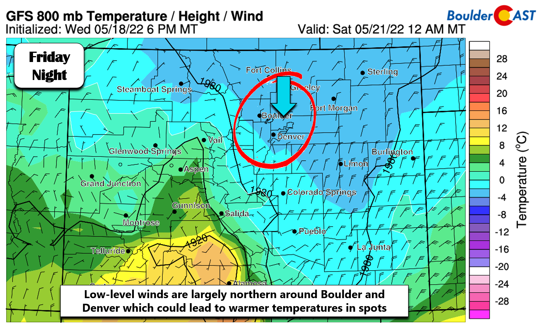
Given all the model support, there’s no doubt that a deluge of precipitation is on the way for our area which will help with the widespread drought conditions. But… let’s not get ahead of things — confidence is still quite low on snow amounts for the Denver Metro area specifically. Why is that? Well melting will be a major issue due to the warm ground temperatures, high May sun angle and even air temperatures which may not get below freezing in some spots. One thing we are worried about for the northern Metro area is the dreaded downslope winds off the Cheyenne Ridge which often keeps temperatures a few degrees warmer from Longmont to Fort Collins to Greeley. The GFS forecast of near-surface winds for Friday night doesn’t look great with almost due northerly winds over the area. With marginal temperatures, this is likely to eat away at the potential snowfall amounts for northern cities. As you will see later, this is reflected in our snowfall forecast map.
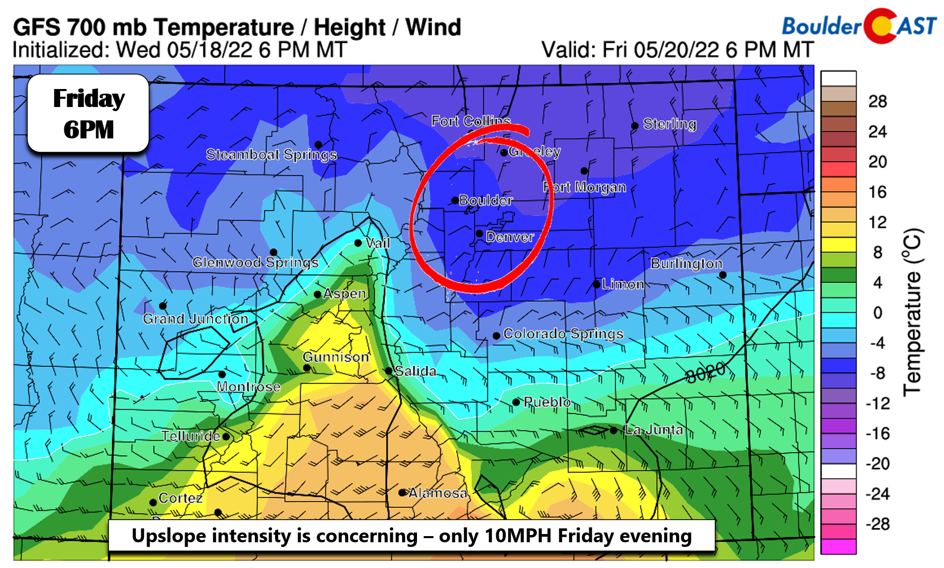
Another issue with the winds we have is with the upslope in general. It is deep and lasts quite a long time — from midday Friday into the afternoon on Saturday — but it’s really not that strong. At best we’re looking at 10-15 MPH east-northeast winds at mountain level. Most of the time though it is less than 10 MPH and less favorable directions. Are all of the models perhaps getting too excited about this storm? Probably not, as there are a lot of other factors besides upslope coming together for this event, including a strong trough moving through, a well-aligned jet streak which could produce embedded heavy snow bands, and added instability which will enhance snowfall rates as well. Despite this, the upslope situation is less than ideal in our eyes.
Timeline
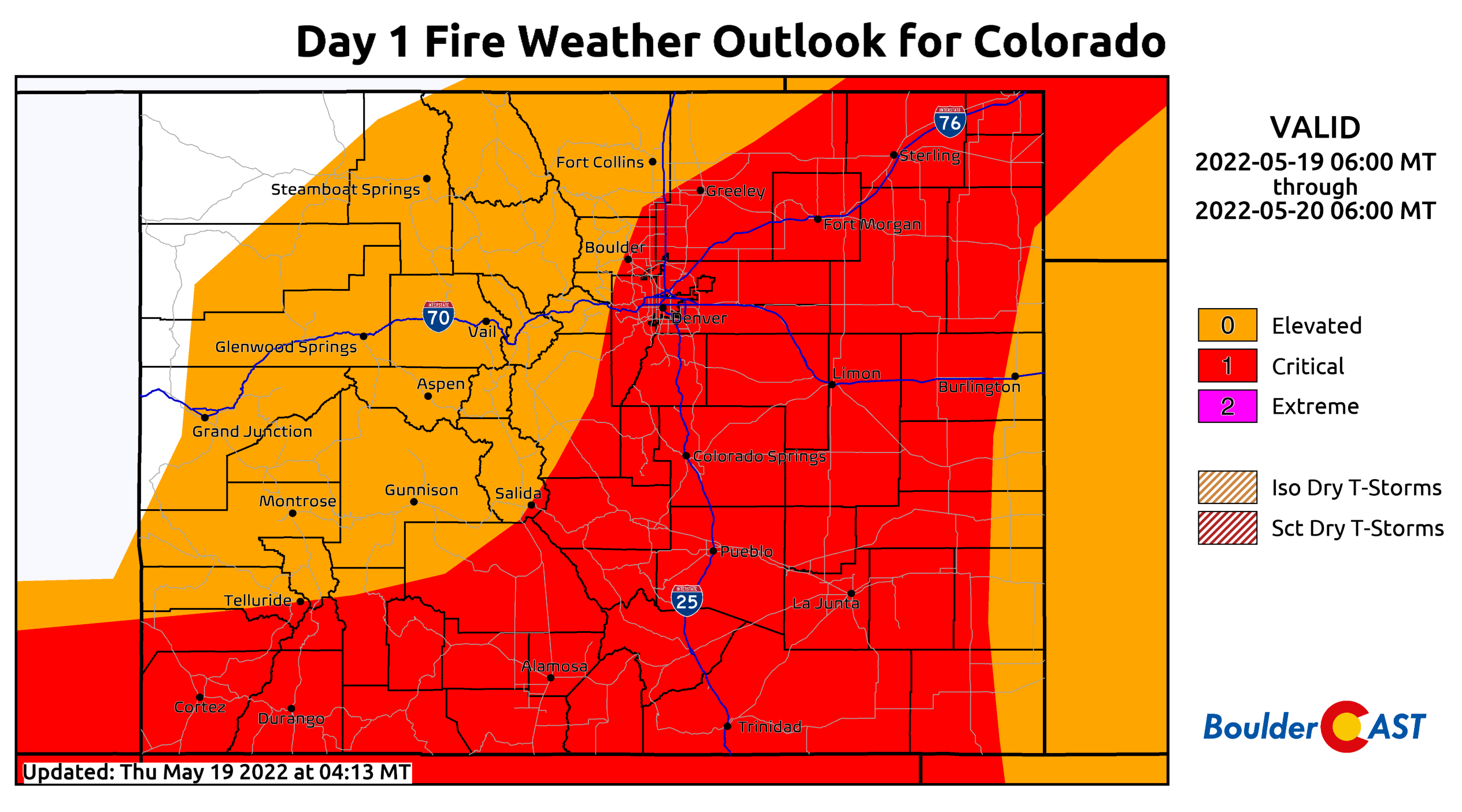
- Thursday: Hot and windy with highs in the mid to upper 80s. West winds gusting 30 to 50 MPH will create high fire danger for much of Colorado. Please use extreme caution and dont let your guard down because snow is on the way — we cannot afford any ignitions on a day like today!
- Thursday evening/night: A cold front blows in from the north and northeast between 8PM and 11PM bringing a sharp drop in temperatures and some familiar smells. The frontal passage should be dry but will kick off the upslope which will be with us into Saturday. Temperatures quickly fall into the 40s and 30s behind this front
- Friday morning: Rain and higher elevation snow begin to overspread the area from the north. We expect Boulder to be seeing some raindrops in the morning as the ingredients come together. Precipitation will begin as rain on the Plains but will be snow above 7000 feet.
- Friday afternoon: A secondary push of cold air and upslope will ensue during this timeframe with temperatures falling further and rain likely to change-over to or mix with snow. It will be tough to get much accumulation below 6500 feet during the day due to the sun angle and above freezing temperatures (but watch out near and after sunset). Slushy snow will begin to pile up in the Foothills though.
- Friday evening & night: Any last lingering spots that haven’t made the change-over to snow will do so during this timeframe. Wet snow will fall through the entire night. It will likely be heavy at times creating difficult travel conditions, mainly in the higher elevations. Temperatures should bottom out between 29 and 32°F in most areas overnight.
- Saturday: Light snow will continue through the morning and into the afternoon for upslope-favored areas. Additional accumulation will be minimal after 8AM or so as the sun rises. Highs on Saturday will be in the middle to upper 30s at best.
- Saturday night: We’ll likely dry out, but skies may not fully clear with the trough still lingering. This should help prevent temperatures from getting too cold, as they would under clear skies, but we’re still expecting another night of below freezing temperatures. Most areas probably land between 25 and 30°F for lows. The poor plants!
- Sunday: A secondary system may impact the area, but it will be lacking the colder air. This will be a minor rain event for the lower elevations with some snow in the Foothills (a few inches)
Snowfall Amounts
The million dollar question, though, is how much snow will we see? The best window for snow to actually stick and pile up across the lower elevations, as we mentioned all along, will come Friday evening into Saturday — essentially during the overnight period when the high-angle May sun will be removed from the equation. This aligns fairly well with when we are expecting the most intense precipitation rates so all signs point to an impactful winter event for the entire area. Since our forecast update yesterday, we have increased our predicted snow amounts a tad for two main reasons:
- Confidence has increased that decent snow will be falling Friday night when accumulation will be least hampered
- Models have stuck to their guns, if not slightly increased the magnitude of this storm for the Front Range
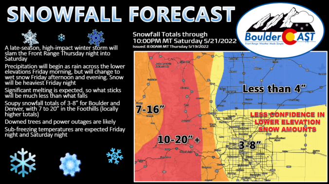
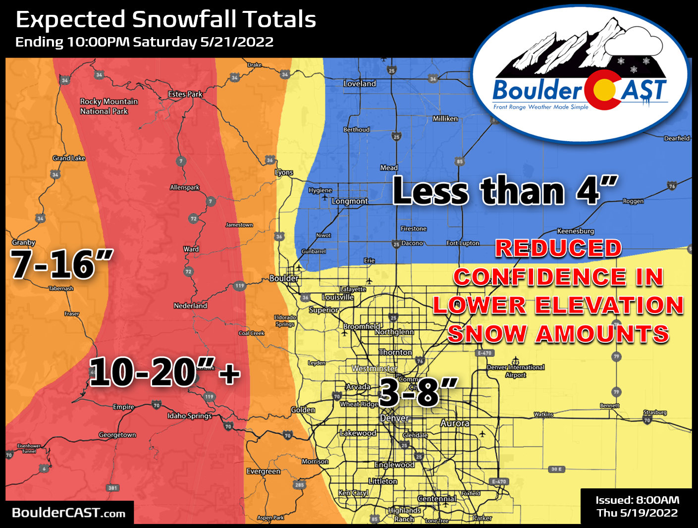
Our updated snowfall forecast map for the event is shown below. This covers all snow falling through Saturday evening. We painted the Denver and Boulder areas with 3-8″ of snow, though confidence is low on this — mostly because we are concerned totals could be higher especially in western and southern suburbs that are slightly boosted in elevation. Further north, temperatures will be warmer and upslope less of a factor — expect less than 4″ from Longmont to Loveland to Greeley. The real winter storm with this event will be in the higher elevations. Our forecast calls for 10-20″ (or more) in the Foothills and Mountains above 7500 feet. The lower Foothills and west of the Divide can expect 7-16″.
This system will definitely be a dumping of much-needed moisture for us, regardless of how much snow lays on the ground or sticks to the trees at the end of it. Expect soupy and slick roads. Expect tree limbs to come down — maybe even some entire trees. Expect power outages in the Foothills with plenty in the Denver area as well. Expect two nights of sub-freezing temperatures.
Copied from our post yesterday — here are some preparations to consider. Make sure to get all this done on Thursday if possible. You won’t want to be messing around in the cold, rain and snow on Friday with any of this:
- Disconnect all outdoor hoses — they will freeze
- Drain all exposed pipes — they will freeze. The main one would be the backflow of your irrigation system
- Bring potted plants indoors until Sunday afternoon
- Cover your growing garden in a manner that won’t destroy the seedlings should 6” of wet snow pile on top
- Plan for winter driving conditions in the Foothills and Mountains, especially Friday afternoon into Saturday midday
- Plan for wet and/or slushy travel conditions in the Metro area, mainly Friday night
- Move your car from underneath any trees to avoid falling limbs Friday night and Saturday
- Plan for power outages, particularly in the Foothills communities but also in the Denver-Boulder areas, too
- If possible, shake off your smaller trees as the wet snow falls to prevent damage
Good luck and we’ll see you on the other side of this late-season winter blast!
Get BoulderCAST updates delivered to your inbox:
Help support our team of Front Range weather bloggers by joining BoulderCAST Premium. We talk Boulder and Denver weather every single day. Sign up now to get access to our daily forecast discussions each morning, complete six-day skiing and hiking forecasts powered by machine learning, first-class access to all our Colorado-centric high-resolution weather graphics, bonus storm updates and much more! Or not, we just appreciate your readership!
Enjoy our content? Give it a share!


You must be logged in to post a comment.