We hope you enjoyed the Columbus Day holiday! In this special weekly outlook, we provide a brief recap of yesterday’s snowstorm, announce the winners of our 2017 First Snow Contest, and detail the warm and sunny weather about to make a rebellious stand across Colorado.
Our first is now behind us!
It sure was nice not to have to wait until mid-November for snow like we did last year. In fact, yesterday’s frozen fluff preceded Boulder’s climatological median date of first measurable snow by a solid twelve days!
The storm system responsible for the snow behaved just as the majority of models projected for many days leading up to the event. This made our job as weather forecasters rather meaningless this time around….
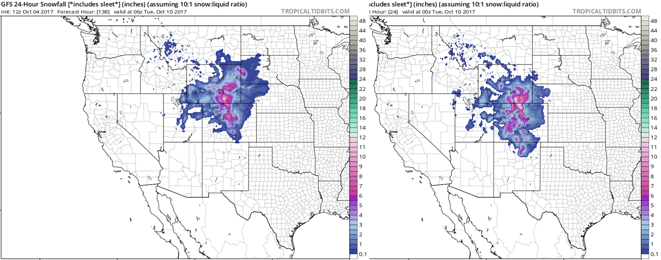
The two snowfall forecast maps below appear very similar, at least across the Denver area. Would you believe that the one of the left is from the GFS model initialized last Wednesday morning (5 DAYS before snow arrived)? The one of the right is also from the GFS , but it was initialized Sunday night (5 HOURS before snow started falling). The timing of the storm was off by 12 to 18 hours, but the details on path, intensity, and wind flow patterns were remarkably accurate five days in advance.

GFS model snowfall forecast from 5 days before the storm (left) and 5 hours before the storm (right). Not bad!
We alerted you to the storm late last week (even earlier if you are a Premium subscriber), so there should’ve been no bewilderment when rain quickly changed to snow Sunday night and continued through much of the day yesterday. Persistent upslope, jet dynamics, and plenty of cold air combined to produce the first accumulating snow of the season for the lower elevations. We have to say “accumulating” as many of us actually got our first taste of winter last Tuesday evening when rain mixed with snow in some locations.
Yesterday’s Daily Weather History graph from BoulderCAST Station shows the evolution of the storm nicely. There was a rain/snow mix for a few hours before the full change-over to snow by 3:00 AM. Moderate snow then lingered through 2:00 PM. A few patches of clear sky before sunset allowed us to reach our daytime high of 37 degrees around 5:30 PM. Finally, temperatures dropped into the 20’s just before midnight! Hello Winter!
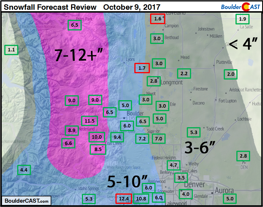
Shown below is our forecast snowfall map issued Sunday morning, with the observed storm totals per location contained in boxes. Green boxes indicate that the observed snowfall was within one inch of the given forecast range, while red was (regrettably) outside the scope of our forecast.
Despite lots of melting out there due to warm ground temperatures, most locations ended up within the bounds of our forecast. While it may not necessarily seem like it, Boulder’s official snow total was 6.0″, with 2.8″ being recorded at Denver International Airport. With most trees still in possession of a bulk of their leaves, many small to medium sized branches were broken, with a few power outages reported here and there. Roads largely remained just wet, except for times when snowfall rates were heavier Monday morning.
Overall, a sizable start to the snow season in northeast Colorado!
And the winners are….
Thanks to those of you whom participated in our third annual First Snow Contest. We had nearly 100 entries.
Boulder’s official first snow was 6.0″ and landed on October 9, 2017. Remember that winners were determined by date first, with snowfall amount used as a tie-breaker. Without further delay, here are the five winners of the contest:
- 1st place: 6-month subscription to Premium + BoulderCAST T-Shirt
- Randy C (Oct 9 – 1.0″)
- 2nd place: 3-month subscription to Premium
- Amy A (Oct 8 – 4.7″)
- Technically second place goes to BoulderCAST’s own Dr. Kren (Oct 10 – 5.0″), but that’s no fun for him to win!
- 3rd – 5th places: 1-month subscription to Premium
- Montana T (Oct 11 – 1.5″)
- Shauna A (Oct 8 – 1.0″)
- Roger L (Oct 7 – 4.0″)
Three of the five lucky folks are new to BoulderCAST Premium!
Winners will receive an email with further instructions in the next few days. Congrats, all! If you didn’t win…don’t worry. We’ll likely host more weather-related contests periodically throughout the year.
And remember, we currently have a promotion running through the end of next week offering a year-long BoulderCAST Premium subscription at 30% discount.
The sun returns indefinitely
The weather of late has brought into question Colorado’s reputation of having abundant sunshine. Since about mid-September, temperatures have largely remained below normal with more cloud cover than many of us are accustomed to. Thankfully, the extended forecast shows a shift in the pattern that should keep most of Colorado high and dry for quite some time. This fits in with our long-term outlook and implications of a La Nina winter which we discussed last week.
Today’s 500 mb mid-level map is below. The system responsible for yesterday’s “flicker of winter” is moving eastward into the Great Lakes. In its wake, southwest flow, ridging, and sunshine return to Colorado. Remarkably, despite sub-freezing temperatures this morning and several inches of snow on the ground, we should warm nicely this afternoon into the mid 50’s under sunny skies.
Looking to the rest of the week, little is worth mentioning as the storm track and jet stream remain to our north in Wyoming and Montana. Temperatures will warm back to near 70 degrees as early as Wednesday, with almost-guaranteed 70’s come Thursday.
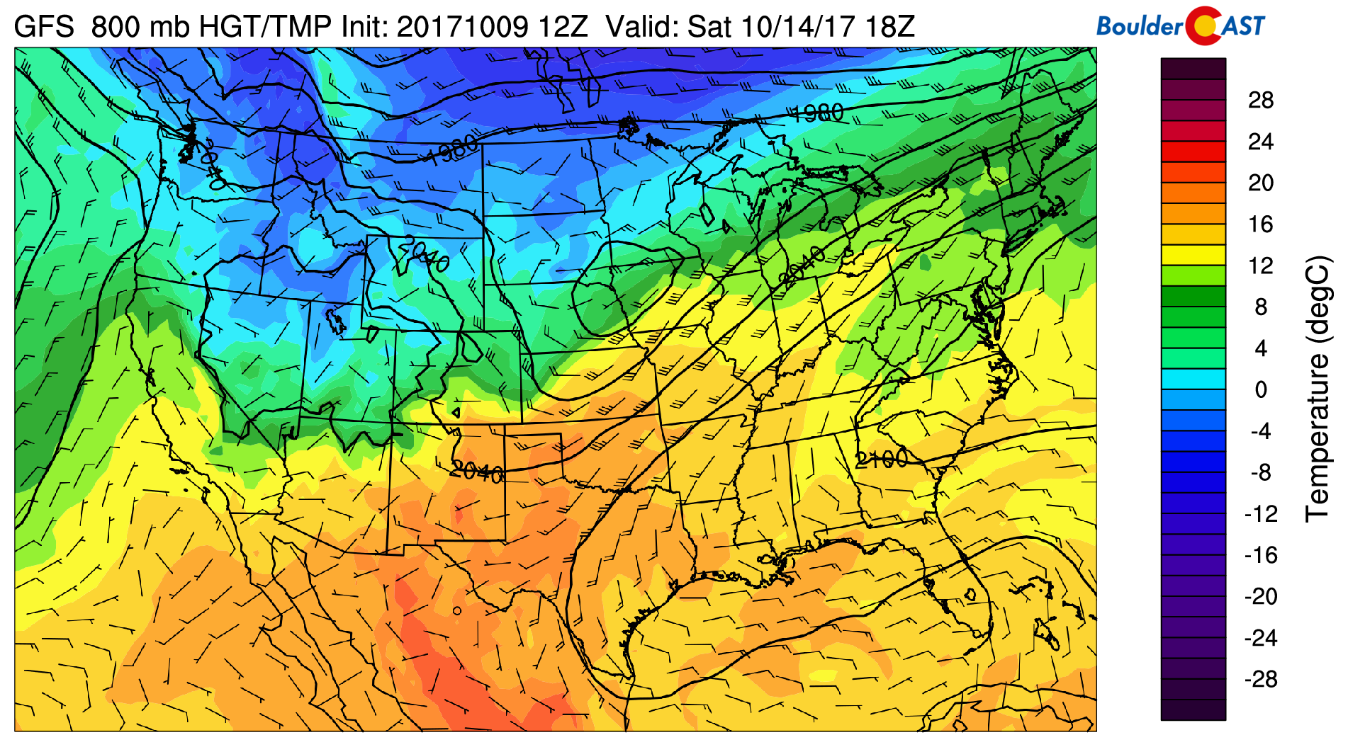
One noteworthy facet: we are watching the potential for a weak Pacific cold front to move through late Friday or Saturday. At this time, the system is very much lacking moisture and we’re doubtful it will produce much more than a few clouds for northern Colorado. Nonetheless, we do expect to see slightly cooler temperatures Friday into Saturday.

GFS 800 mb temperature map for Saturday afternoon. The cooler airmass and northerly winds behind the cold front are visible in northern Colorado.
Enjoy the (shortened, for some of you) work week!
Forecast Specifics:
Tuesday: After a hard freeze in the morning, the snow will be melting quickly under sunny skies as temperatures rebound into the mid 50’s on the Plains, with low 40’s in the Foothills.
Wednesday: Mostly sunny, warm, and dry. Highs near 70 degrees on the Plains and in the upper 50’s in the Foothills.
Thursday: Sunny and warm…probably the warmest day of the week. Highs across the Plains will be in the mid 70’s, with mid 60’s in the Foothills.
Friday: Mostly sunny, dry, and slightly cooler. Temperatures seasonal in the mid to upper 60’s on the Plains with mid 50’s in the Foothills.
Weekend: The upcoming weekend looks pleasant across the region. While Saturday will be cooler most likely resulting from a wimpy cold front, Sunday should see temperatures rebound several degrees. Both days will have plentiful sunshine with next to no chance of precipitation.
High Country: The quiet week across the Metro area will also translate into tranquil weather for the mountains. Abundant sunshine will dominate each and every day this week! Get out there and enjoy it! Find the latest forecasts for the mountains over at our SummitCAST page.
DISCLAIMER: This weekly outlook forecast is was created Tuesday morning and covers the entire upcoming work-week. Accuracy will decrease as the week progresses as this post is NOT updated. To receive daily updated forecasts, subscribe to BoulderCAST Premium.
Share our forecast:
Tue
Wed
Thu
Fri


Temperature
55
71
73
65


Precip Chc (Plains)
0%
0%
0%
0%


You must be logged in to post a comment.