
Following a very chilly Sunday, it will be business-as-usual for the week ahead with the sweltering heat returning to the Metro area. The same high pressure that has been plaguing us for weeks on-end will isolate Colorado from the pool of much-needed monsoon moisture, thus limiting rainfall chances for the foreseeable future. Read on for the disappointing details.
Did you enjoy the one day break from the heat?
Yesterday was quite a treat in terms of weather! The afternoon high at BoulderCAST Station on Sunday was just 70 degrees, with cloudy skies and spotty raindrops throughout the day.

The cool-down was thanks to a drawn-out cold front pushing across Colorado. You can see the front sweeping through in the GOES-16 water vapor animation below.
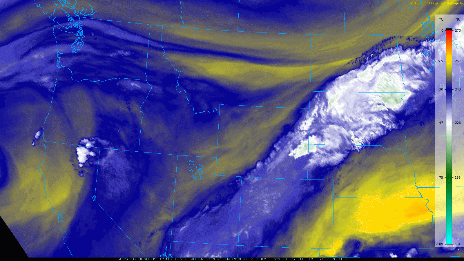
GOES-16 water vapor animation from Sunday into early Monday. A cold front is seen moving across Colorado and the upper Midwest.
Most of the heavier thunderstorm activity was confined to areas south and east of Denver. However, the “thunder-less” rain showers across Boulder and Denver tapped into juicy moisture and produced a decent amount of rainfall for most locations. 0.25 to 0.50 inches was common across the region.

Rainfall totals for the Denver Metro area on July 15, 2018
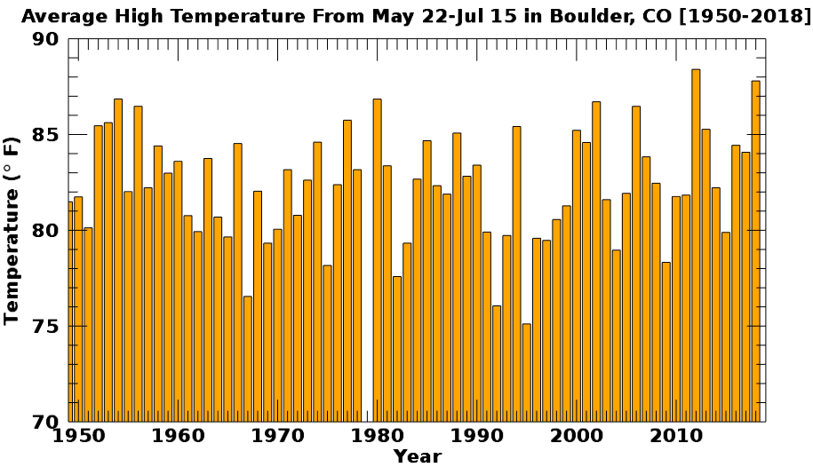
Sunday was a great reprieve from what has otherwise been a VERY hot summer. For the time period of May 22 to July 15, this year has been the second hottest in Boulder’s history since 1950 (just behind 2012). The mean high temperature during this time period was 87.8°F. This is a full 7 degrees above normal for this eight-week period!
So far in 2018, we’ve had 23 days reach the 90-degree mark in Boulder. This is the 7th highest amount since 1950.

With ten more weeks of summer left, we are well ahead of schedule on this front. The normal amount for the entire calendar year is just 29 days of 90-degree heat in Boulder. As you’ll soon find out from our forecast, we’ll likely be reaching that count by the end of the upcoming weekend…

Alongside the heat, drought continues to intensify across our state. 77% of Colorado is now experiencing drought, up from only 27% six months ago. A current map of the drought is shown below. While the Denver Metro area is not technically within the drought’s boundaries, we have seen “Abnormally Dry” conditions migrate northward and overtake our region in the last month or so. This classification is a precursor to drought if meaningful rainfall does not arrive soon…

The week ahead: The heat continues
Chances for rain will remain early on this week, but will be lessened thanks to drier air working into Colorado from the northwest. As of Monday morning, a flattened ridge of high pressure is situated off the coast of southern California stretching eastward into the Desert Southwest. The mid-latitude storm track resides well to our north and remains active, but essentially is irrelevant to Colorado at this time (as is typical during the summer months).

GFS 500 mb vorticity forecast for Monday.
Models are in good agreement that the ridge will amplify slightly and sluggishly move eastward through the week. See the 500 mb height anomaly animation below, which goes through Saturday.

GFS 500mb height anomaly forecast animation through Saturday.
Unfortunately this ridge pattern will isolate Colorado from an otherwise healthy pool of monsoon moisture…the clockwise flow around the ridge will deflect most of it westward and away from our region. You can see this happening in the precipitable water animation below. Notice how the monsoon moisture plume in southern Arizona doesn’t make any progress towards Colorado this week. It gets pushed westward towards southern California.

GFS precipitable water forecast animation loop through Saturday.
While there will be enough moisture for a few isolated storms to form on Monday and Tuesday for the Front Range, things will really dry out Wednesday and beyond with heat once again becoming the headline. Highs beginning on Tuesday will return to the 90’s, with hot weather set to continue right into the weekend. The warmest days look to be Wednesday and Thursday with afternoon temperatures climbing into the upper 90’s.
A shallow backdoor cold front Thursday night may lower high temperatures a tad on Friday, with even enough moisture for a few isolated storms to form as well across the Metro area. The specifics of this frontal feature late in the week remain fuzzy, but we will include note of this in our forecast.

GFS 800 mb temperature and wind forecast map for Friday showing a potential cold front for eastern Colorado associated with a low pressure in the Great Lakes.
Don’t fear….All hope for rain is not lost. Monsoon season will be raging for northwestern Mexico and Arizona this week. It’s definitely not going away anytime soon. We’ll just have to wait it out for the next favorable atmospheric set-up to push some of it our way again. Admittedly, though, we’re not seeing any signs of this yet, even for next week…
Tucson, AZ daily average dew point tracker. Monsoon moisture remains strong across southern Arizona.
Forecast Specifics:
Monday: Some low clouds early, then partly sunny with isolated afternoon and evening thunderstorms. Highs in the upper 80’s across the Plains with middle 70’s in the Foothills.
Tuesday: Overcast in the morning, then partly cloudy with isolated afternoon and evening thunderstorms. A few storms from Denver east could be severe with 1″ hail and 60 mph wind gusts. High temperatures in the lower 90’s for the Plains with upper 70’s in the Foothills.
Wednesday: Sunny, hot and dry. High temperatures in the middle 90’s across the Plains with middle 80’s in the Foothills.
Thursday: Mostly sunny and hot. Highs for the Plains in the mid to upper 90’s, with mid 80’s in the Foothills.
Friday: Mostly sunny with isolated afternoon and evening thunderstorms. Highs near 90 degrees for the Plains with upper 70’s in the Foothills.
Weekend Outlook: The ridge of high pressure may weaken slightly over the weekend allowing for hints of monsoon moisture to permeate into the Mountains at least. With this, look for continued hot weather in the 90’s with some chances for afternoon and evening storms, particularly across the higher elevations.
High Country: Isolated storms will be possible statewide on Monday and Tuesday across Colorado’s Mountains. Wednesday through Friday will largely see storms confined to the southern tier of the state, with scattered to widespread coverage Thursday and Friday. Check out SummitCAST for twice daily updated forecasts for more than 120 Colorado hiking destinations!

DISCLAIMER: This weekly outlook forecast was created Monday morning and covers the entire upcoming week. Accuracy will decrease as the week progresses as this post is NOT updated. To receive daily updated forecasts, subscribe to BoulderCAST Premium.

.
Share our forecast!


You must be logged in to post a comment.