
Premium Storm Update (Mon Feb 5 at 1:30 PM) Ensembles are out to lunch for tonight’s snow! We provide a brief storm update along with a discussion on why the ensemble model runs are worthless for this particular wintry event. READ NOW
—
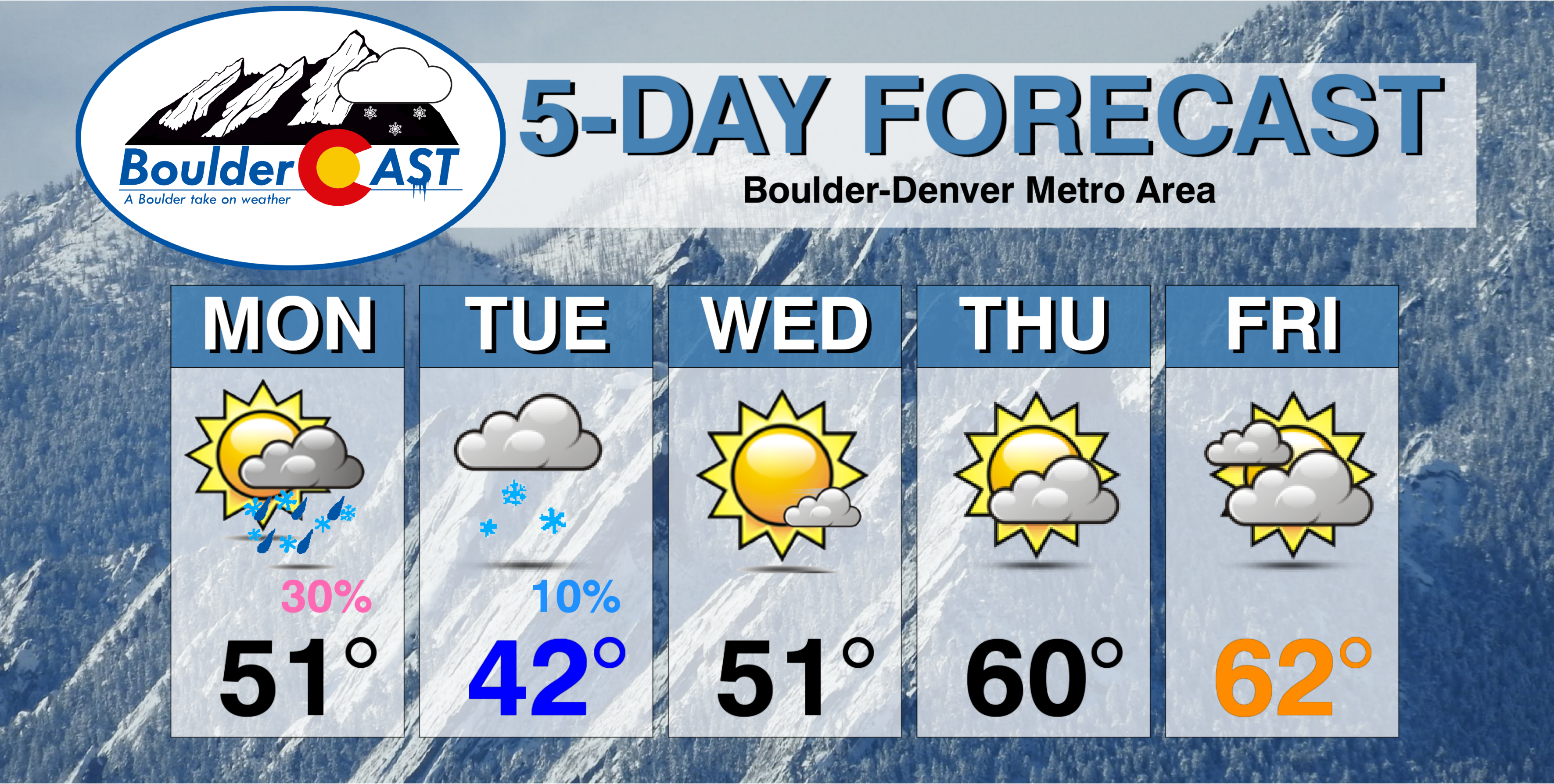
This week will see rain changing to snow Monday evening. We have included our official snowfall forecast map. We’ll then see a significant warming trend through the rest of the week as a lee trough develops, with the potential for more snowfall during the upcoming weekend.
Rain & snow Monday into Tuesday
It seems as though we have been stuck in northwest flow for weeks now….a pattern which is favorable for frequent (but brief) cold air intrusions into northeast Colorado, but not much in the way of snowfall. The upcoming week will be no exception….
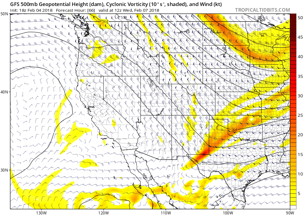
A shortwave embedded in the flow is moving into Colorado today (circled in pink below), with widespread snow already developing in the High Country.
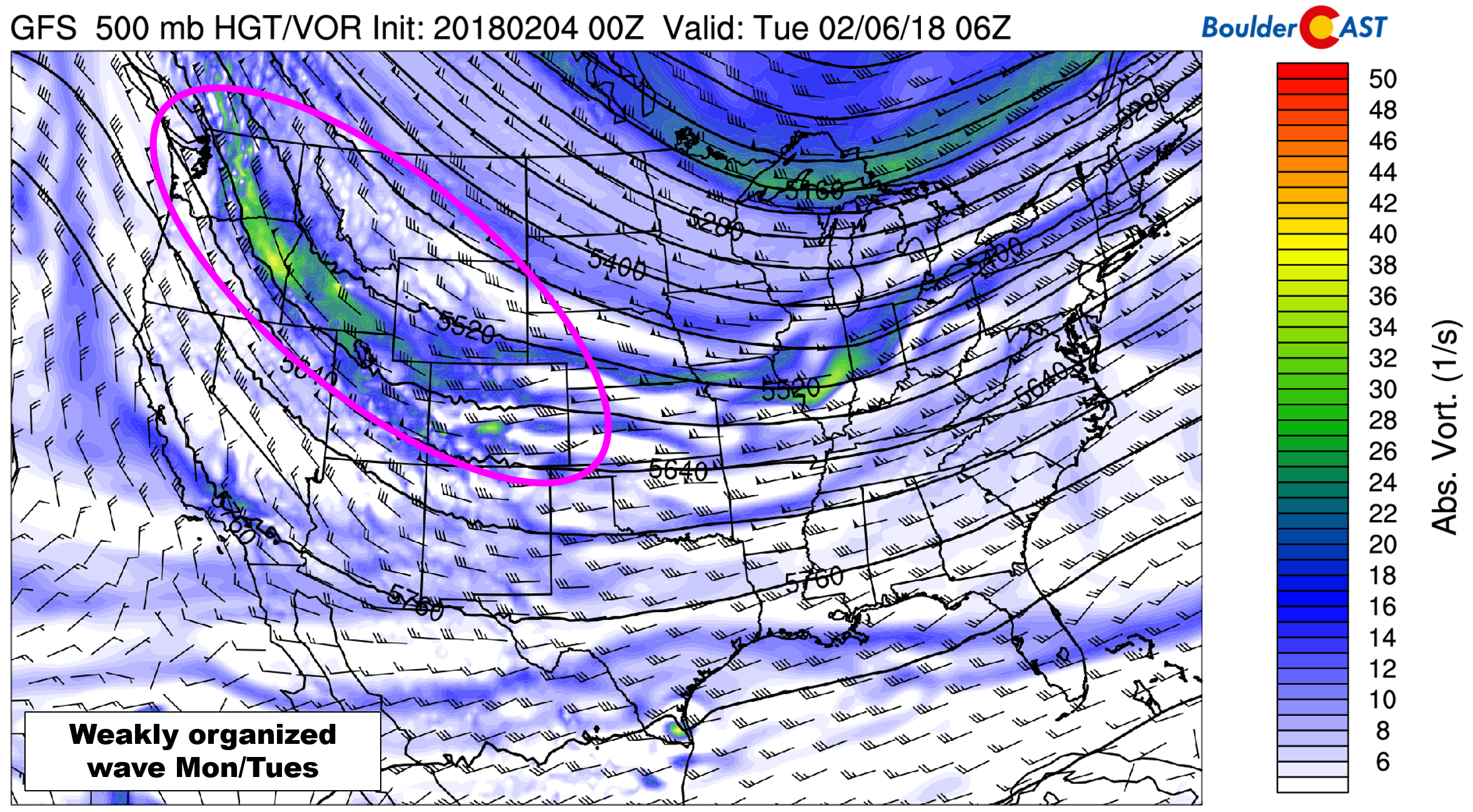
GFS 500 mb vorticity map for Monday evening showing a broad and disorganized trough approaching Colorado
Temperatures are expected to warm to near 50 degrees before a cold front arrives later this afternoon. Before the front and as it passes, winds will be gusty up to 35 mph through the day. The timing of the cold front looks to be around 2:00 PM, give or take an hour or two.
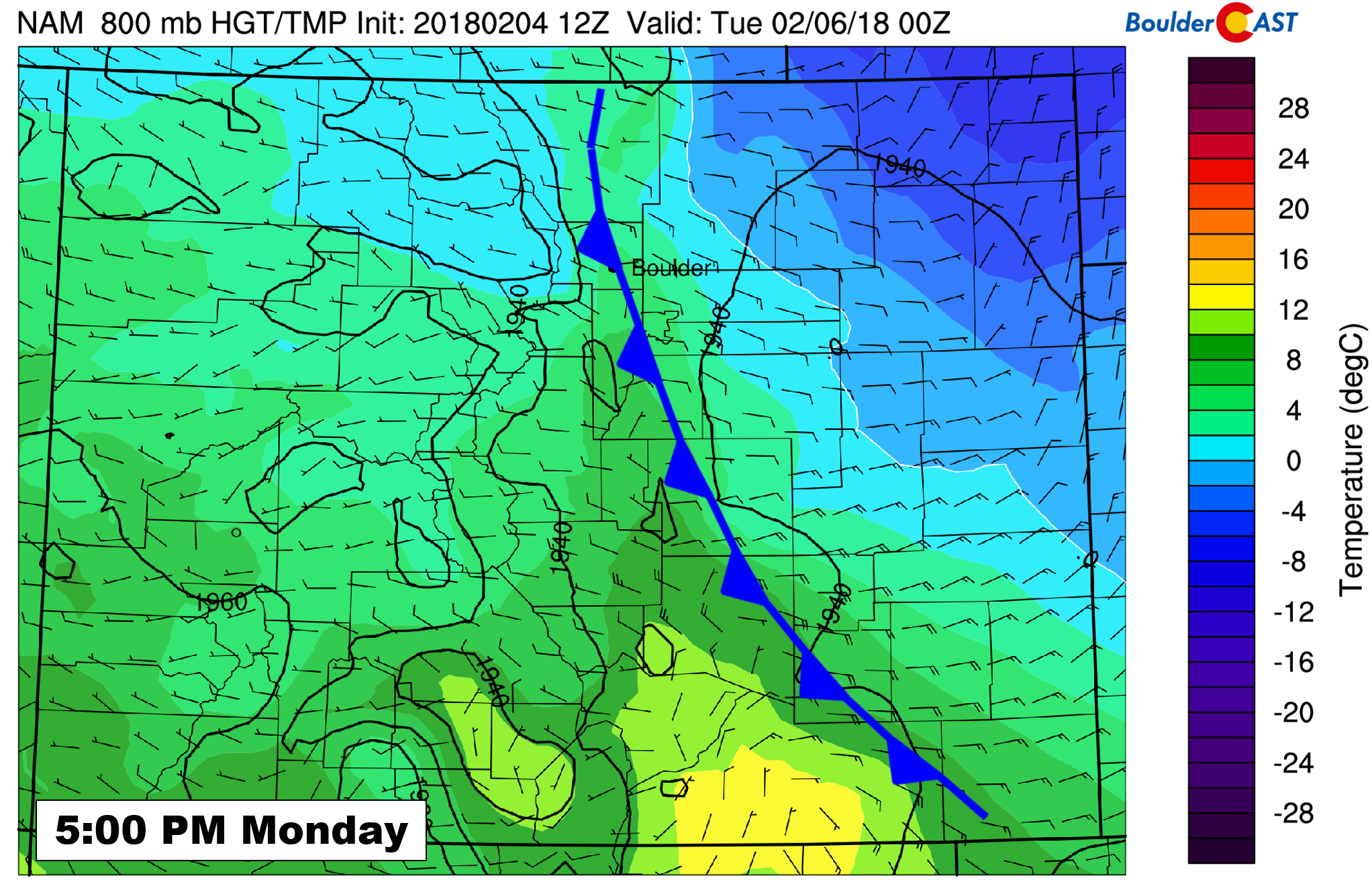
NAM 800 mb temperature and wind forecast for Monday at 5:00 PM. The front will be pushing through the Metro area.
While we may see a few isolated rain showers before sunset today, we expect most precipitation to fall after the front passes in the form of light snow as snow levels tumble to below 5,000 feet.
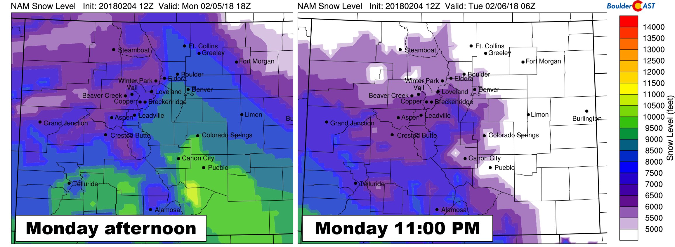
NAM-derived snow level forecast for Monday afternoon (left) and Monday night (right).
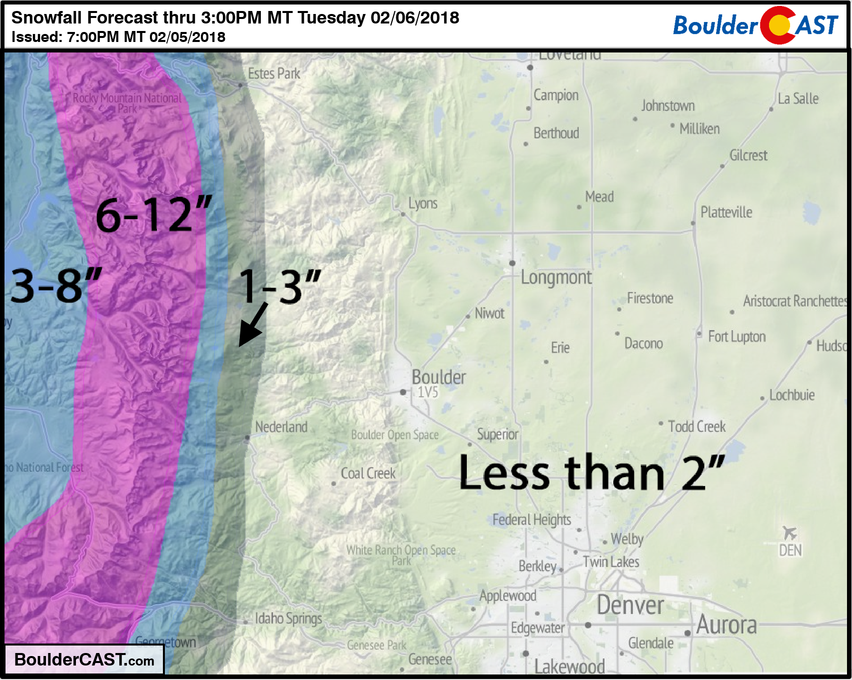
Overall, the forcing for snow east of the Continental Divide is not great. Large-scale lift and upslope are not the primary players tonight. Instead, jet-forced snow bands are the main concern. While we expect them to be few and far between, it only takes one to drop a quick inch or two of snow. The best chances of this happening will be from 6:00 PM this evening through 4:00 AM Tuesday morning. For this reason, most areas should see very little snow overnight, with up to 2″ in areas impacted by a heavier band. In the Mountains, totals could exceed a foot on west-facing slopes! Some spill-over from the Divide can be expected along Peak to Peak Highway near Ward, Allenspark and Ned, about 1-4″ through the day Monday into Tuesday morning. Our snowfall forecast map through Tuesday early afternoon is shown below.
Isolated snow may linger into early Tuesday morning for the Plains, and into Tuesday afternoon for the Mountains. Mostly cloudy skies will keep temperatures relatively cool on Tuesday in the lower 40’s. Peaks of sun will be possible in the afternoon.
Northwest flow turns westerly through Friday
The rest of the week will be relatively quiet across the state of Colorado as drier northwest flow slowly turns due westerly by Friday. The drier air will shut down the snow in the Mountains, while the shift to westerly winds will facilitate a nice warming trend for the region as a lee trough develops. Highs are expected to climb back to near 50 on Wednesday, then push towards 60 on Thursday and Friday.
GFS 500 mb vorticity and wind forecast animation showing the flow for Wednesday through Friday evening. Northwest flow will turn westerly over time.
Models are all over the place as to what happens the second half of Friday into the weekend. You can see at the very end of the animation above that a trough may dive southeast into Colorado from Idaho. The specifics are unknown at this time, but it looks as though colder air will be returning for the weekend with the potential for more snow Friday night into Sunday. This broad window is due to timing differences between the GFS and European models right now. Our best guess is that we’ll squeak at least one more mild day on Friday, with things cooling off substantially for the weekend with snow chances come Saturday.
Forecast Specifics:
Monday: Partly sunny and windy with isolated afternoon rain showers changing to snow showers behind a cold front. It will be all snow above ~8,500 feet. Winds may gust up to 35 mph during the day. Temperatures will top out near 50 across the Plains and in the lower 40’s in the Foothills. Isolated jet-forced snow bands will develop after sunset and continue intermittently through the night. The Plains will generally see less than 1″ of snow, with up to 4″ in the highest Foothills that see spill-over from the Divide.
Tuesday: A few lingering snow showers before sunrise in the morning, then mostly cloudy and cool. Highs in the low 40’s for the Plains with upper 20’s in the Foothills.
Wednesday: Mostly sunny and mild. Highs near 50 across the Plains, and upper 30’s in the Foothills.
Thursday: Partly cloudy with temperatures in the upper 50’s over the Plains and mid 40’s in the Foothills.
Friday: Mostly cloudy but warm with highs near 60 degrees for the Plains and upper 40’s in the Foothills. Uncertainty in temperatures is elevated as some models bring a cold front through the region during the afternoon. Our forecast assumes this front will stay to the north.
High Country: Heavy mountain snow will fall during the day Monday and continue into Tuesday afternoon for west facing slopes and the higher valleys. Expect storm totals of 5-12″ by Tuesday afternoon. Both Monday and Tuesday should be decent ski days. Moisture-lacking northwest flow will then lead to dry weather Wednesday through Friday with no snow expected and temperatures generally above normal. Find the latest forecast for all your favorite Colorado ski resorts on our PowderCAST page.
DISCLAIMER: This weekly outlook forecast was created Monday morning and covers the entire upcoming week. Accuracy will decrease as the week progresses as this post is NOT updated. To receive daily updated forecasts, subscribe to BoulderCAST Premium.

.
Share!


You must be logged in to post a comment.