After a brief review of last Friday’s snow, we cover the forecast for the upcoming week. Overall it will be quiet with very comfortable temperatures, though we are watching a Pacific cold front set to bring Mountain snow, strong winds, and cooler weather towards the end of the week.
Snowy recap from last Friday
As the strong cold front moved through the region last Friday morning, temperatures quickly fell into the 20’s and stayed there the rest of the day. The air on the backside of the front was surprisingly cold for early April….some 40 degrees below normal.
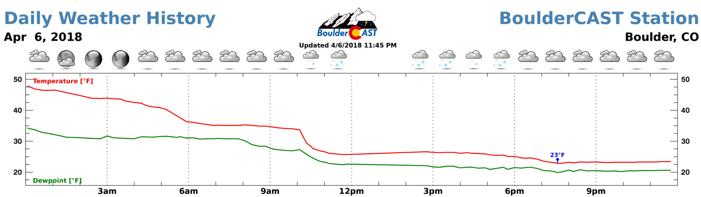
Temperature and dew point data from BoulderCAST Station on April 6, 2018. Notice the cold frontal passage.
As expected, shallow but persistent upslope generally kept the snowfall banked up against the Foothills through the day. Light snow was falling in Boulder for more than sixteen straight hours from 10:00 AM Friday through the wee-morning hours Saturday.
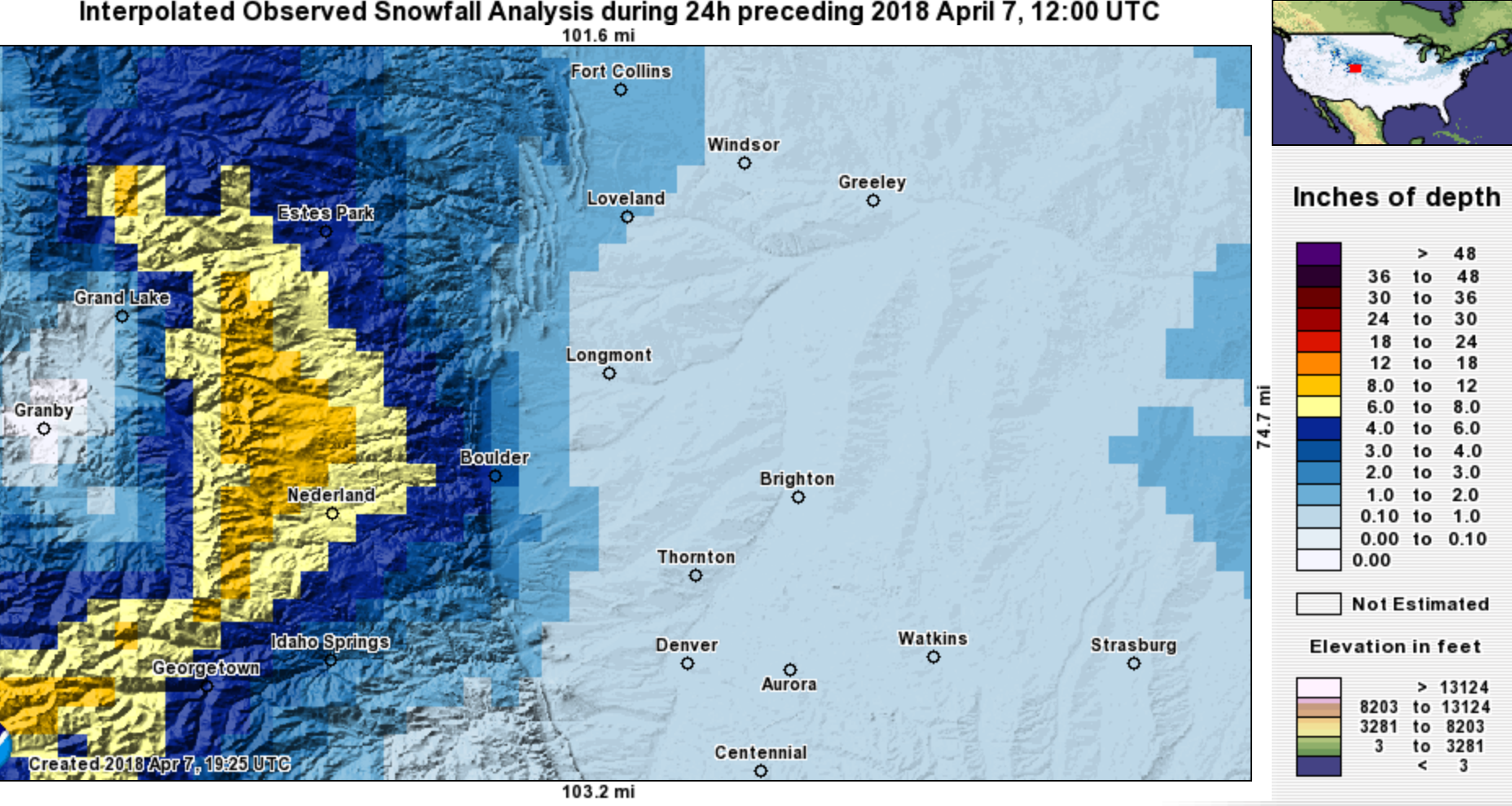
Snowfall totals map (interpolated) from the April 6-7, 2018 snow event. Accumulation was mainly confined to areas in and near the Foothills.
Shown below is our original snowfall forecast map issued Thursday morning, with the observed storm totals per location contained in boxes. Green ones indicate that the observed snowfall was within one inch of the given forecast range, while red was outside the scope of our forecast.
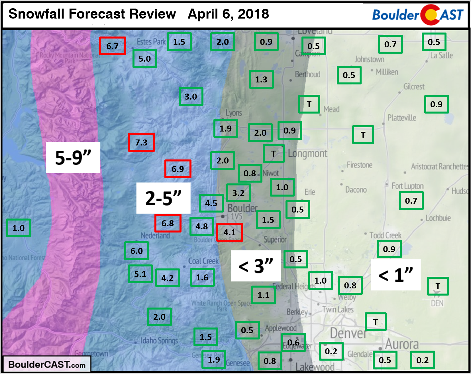
The official snow report in Boulder was 4.1″ and just a trace in Denver. The highest totals of 6 to 8″ occurred across the Foothills of Boulder County. Areas more than a few miles from the base of the Foothills saw 1″ or less of snow.
Head over to our 2017-18 Winter Summary page to check-up on our seasonal snow totals.
The week ahead
By the time your reading this post, the best chance of precipitation for the week may already have passed. A weak shortwave is zooming across Colorado as of Monday morning. This wave can be seen in the 500 mb map below. This system spawned thunderstorms yesterday afternoon across the Mountains and currently is producing spotty rain and snow showers north of Denver.
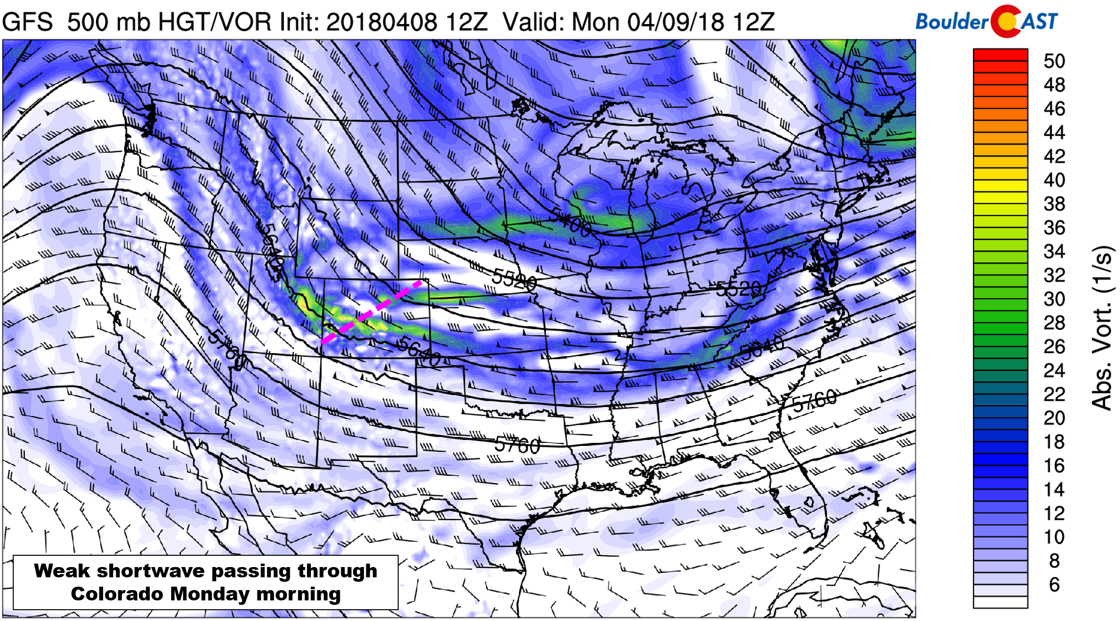
GFS 500 mb vorticity map for Monday. A weak shortwave is moving across Colorado.
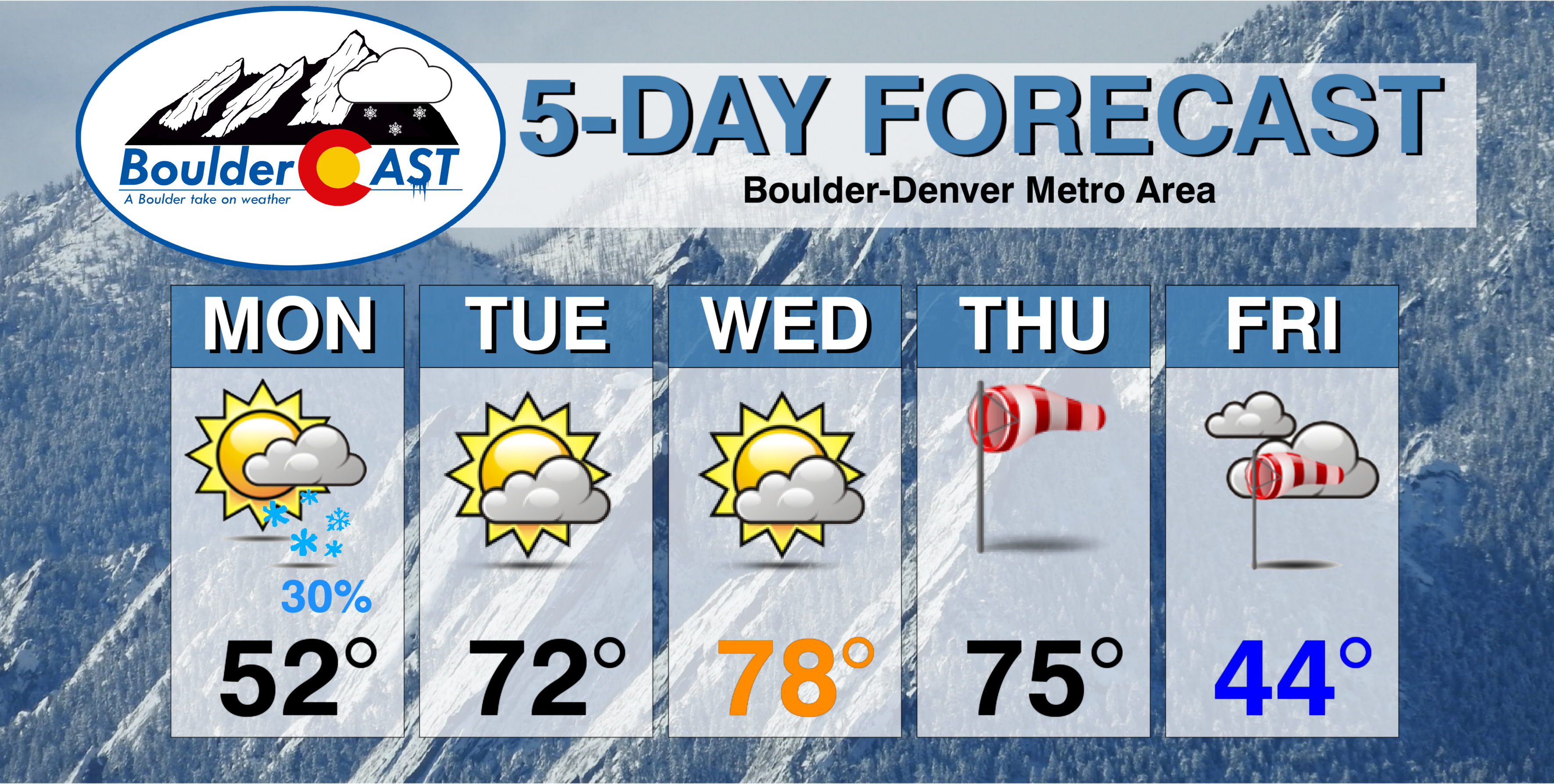
This wave will have minimal impacts east of the Divide, with just a few scattered rain and snow showers possible across the Metro area this morning. Any snow accumulation across the Plains will be 1/2″ or less. Had this system lined-up better with afternoon solar heating, we may have seen a few thunderstorms and more precipitation overall. Nonetheless, skies will be partly cloudy through the day with high temperatures in the low to middle 50’s on Monday.
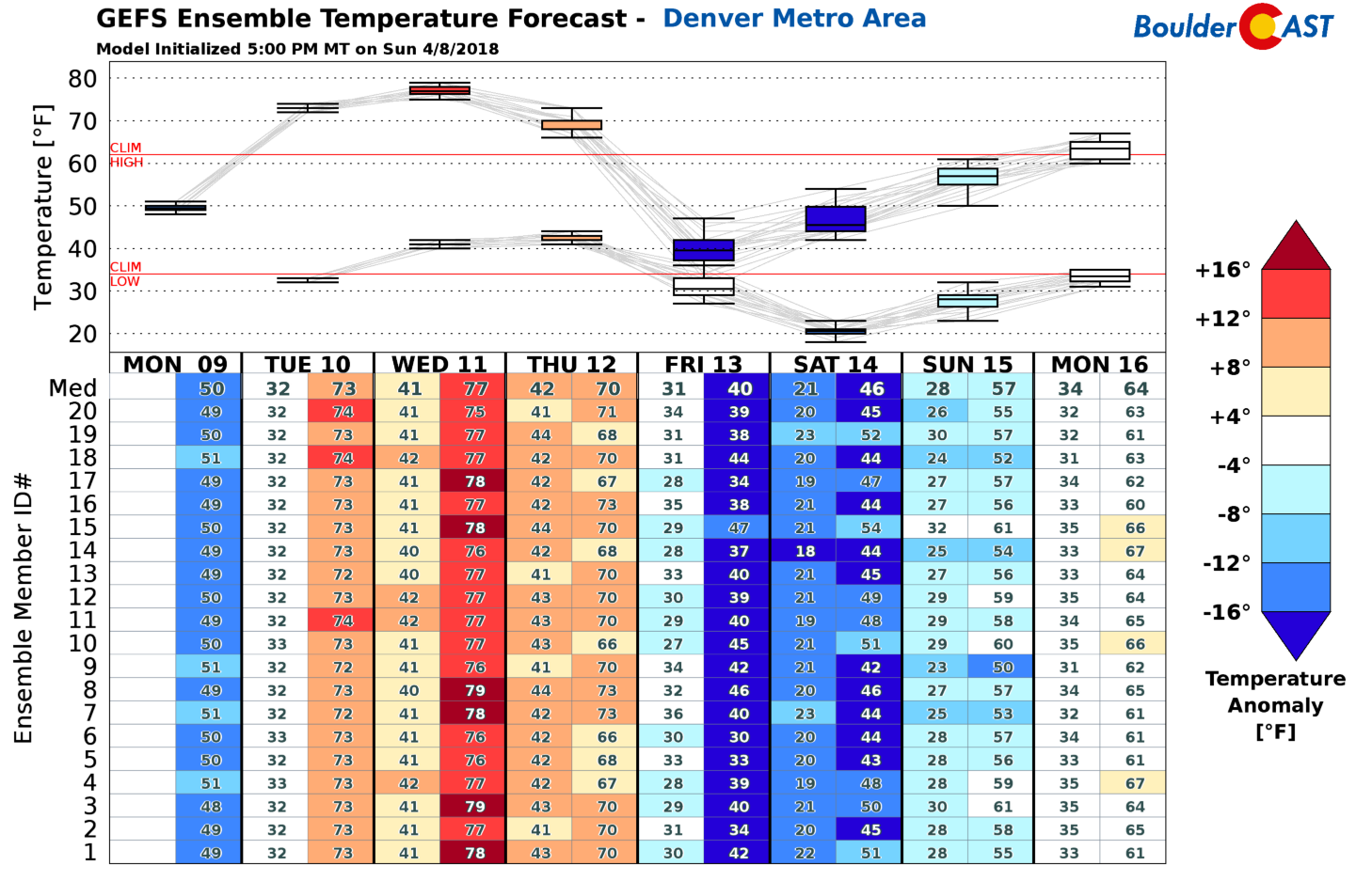
Our average high temperature this time of year is 61 degrees already….as you may expect, it doesn’t really take much southwest flow to push our temperatures into the 70’s. This will be the case for Tuesday, Wednesday, and Thursday this week as a ridge briefly takes shape across the Rockies. Also note that by Wednesday evening (right map below), a trough will be coming ashore into the Pacific Northwest. This will be a player for us late in the week.
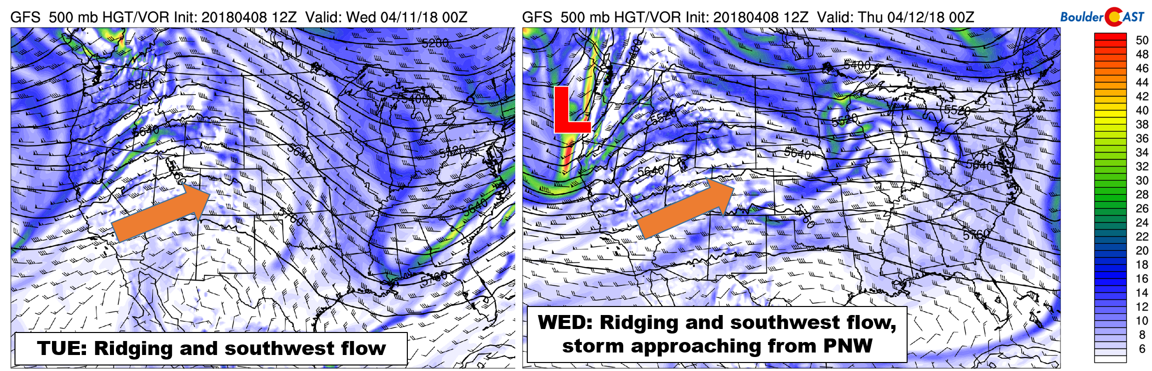
GFS 500 mb vorticity maps for Tuesday (left) and Wednesday (right). Warm southwest flow will be warming up the state.
Highs Tuesday will be in the low 70’s and in the upper 70’s on Wednesday. There could be a fair amount of cloud cover with moisture levels elevated aloft…especially Tuesday afternoon into Wednesday morning. Wednesday’s surface temperature departure from normal map below shows the warmth across the southwestern United States. We may even be warm enough to reach the lower 80’s on Wednesday, our first 80-degree day of 2018, depending on cloud cover of course…
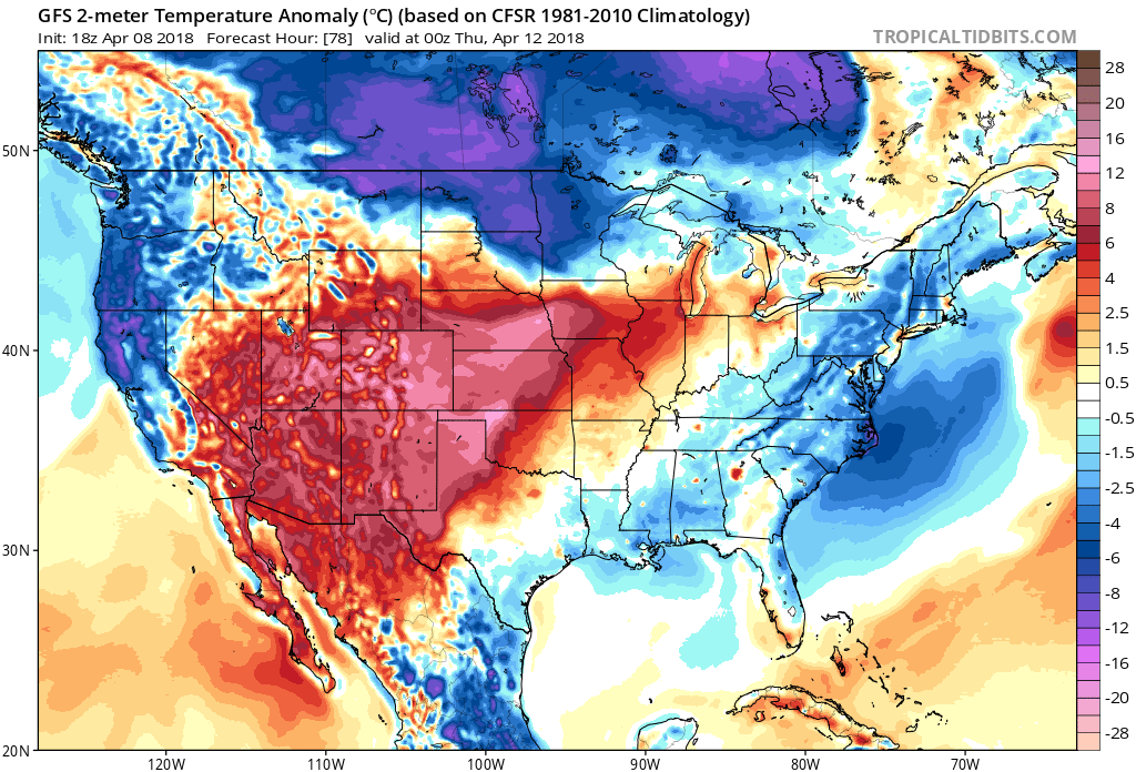
GFS 2-meter temperature departure from normal map for Wednesday afternoon.
Changes by week’s end…snow?
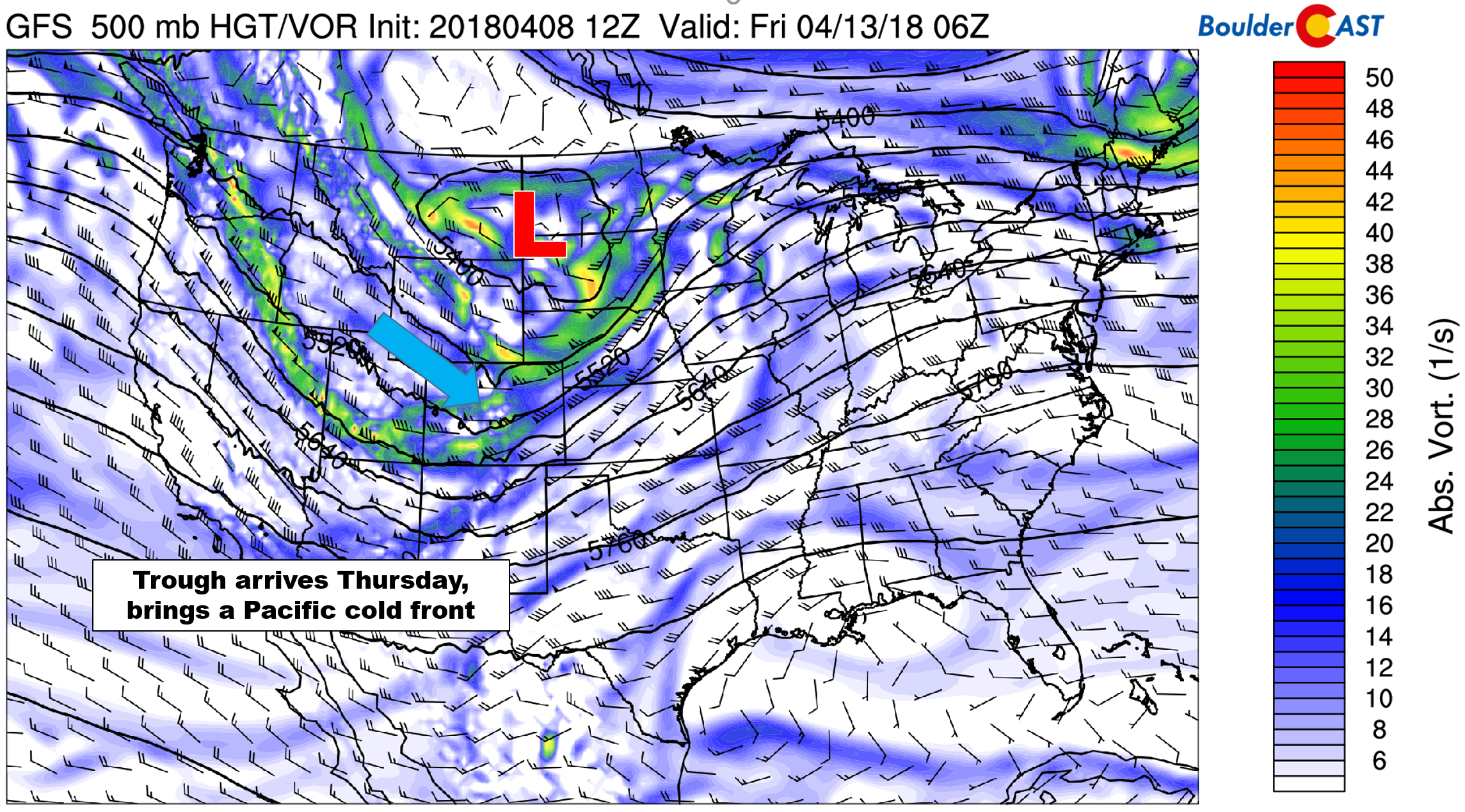
The Pacific trough mentioned earlier looks to arrive in Colorado on Thursday during the day. The bulk of the energy from the trough is forecast to remain well north and east of Colorado across the Dakotas. Despite this, moist and cooler northwest flow will impact the Mountains and eventually move into the Metro area in the form of a Pacific cold front. Four days out, the timing on everything will probably change, but latest models trends bring the front through Boulder and Denver Thursday afternoon or evening.
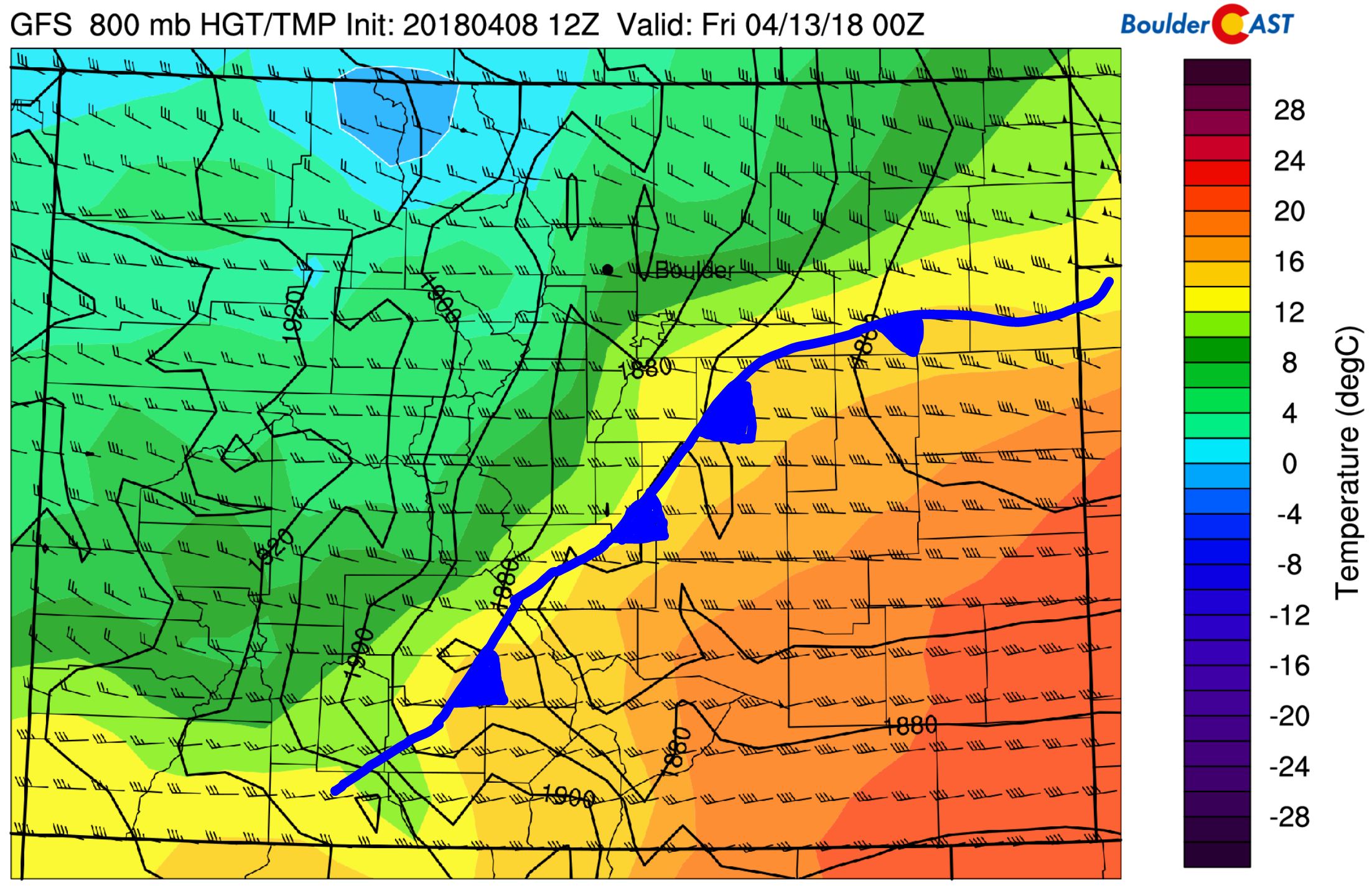
GFS 800 mb temperature and wind forecast for Thursday at 6:00 PM. The position of the cold front is annotated.
Temperatures on Thursday should peak in the 70’s again (depending on the timing of the front) and then drop drastically as the front passes. We’re not expecting an precipitation across the Metro area with this front…the downslope effect should be enough to keep the area dry. Several inches of snow will be possible in the Mountains, though.
GFS 500 mb vorticity map for Thursday night. A trough will be moving across the northern Rockies with cooler air filtering into Colorado from the northwest.
Winds also appear to be rather strong on Thursday.…southwesterly before the front passes, then northwesterly on the backside. Gusts of 45+ mph are indicated by the GFS, and 35+ mph by the European model. These winds combined with low relative humidities will likely create dangerous wildfire conditions on Thursday.
Friday will see continued blustery weather, with a much cooler airmass in place across Colorado. Highs may remain in the 30 to 40’s, with even a chance of light snow in the during the afternoon and evening as an even colder backdoor cold front may impact northeast Colorado. This will be wrap-around from the main low pressure located across Nebraska/South Dakota. Uncertainty is high for this facet of the storm, but any snow accumulation would likely be light.
Get your seat-belts fastened…we’re in for a roller-coaster ride this week:
Forecast Specifics:
Monday: Scattered rain/snow showers are expected in the morning, with dry and partly cloudy skies for the second half of the day. Less than 1/2″ of snow accumulation is expected in the morning. Highs will be in the low 50’s for the Plains, with low 40’s in the Foothills.
Tuesday: Morning sunshine with increasing afternoon wave clouds. Highs will be near 70 degrees for the Plains, and in the upper 50’s in the Foothills.
Wednesday: Very warm with morning clouds giving way to mostly sunny skies. High temperatures will be near 80 degrees across the Plains, with mid 60’s in the Foothills.
Thursday: A warm and windy day with a potential cold front arriving in the afternoon or evening. Temperatures will tumble as the front passes, but overall, we think Thursday will be a fairly nice day if you can handle some wind. Gusts at times could reach 40 mph. We expect dangerous fire conditions during the day conducive to rapid growth. Temperatures will likely top out in the 70’s and then fall into the 50’s with blustery northwest winds.
Friday: Mostly cloudy, much colder and likely breezy with highs in the upper 30 to middle 40’s for the Plains and in the 30’s in the Foothills. A potential back-door cold front during the afternoon/evening could produce snow showers across the Metro area. Any accumulation would be fairly light.
High Country: Light snow will taper off in the High Country by early afternoon Monday. 1-3″ of accumulation is expected west of the Divide above 10,000 feet. Dry and warm weather will be in place Tuesday and Wednesday. The next trough will begin to impact the Mountains Thursday afternoon into Friday night with light to moderate snow accumulations possible during this time. Find the latest forecast for all your favorite Colorado ski resorts on our PowderCAST page.
DISCLAIMER: This weekly outlook forecast was created Monday morning and covers the entire upcoming week. Accuracy will decrease as the week progresses as this post is NOT updated. To receive daily updated forecasts, subscribe to BoulderCAST Premium.

.
Share our forecast!


You must be logged in to post a comment.