The second week of September will bring a prolonged period of unseasonable warmth to the Front Range along with minimal rainfall. The early to mid-week period will actually have slight chances for rain, but late-week will have much drier air and gusty winds leading to elevated fire danger. Temperatures will remain close to 90 degrees every single day in the extended, with some influx of wildfire smoke at times from the Pacific Northwest. Read on for all the details.
This week’s highlights include:
- High-Based Storms Early Week: A small amount of moisture will be around Monday and Tuesday allowing for isolated gusty thunderstorms to develop — minimal rainfall will accompany them though.
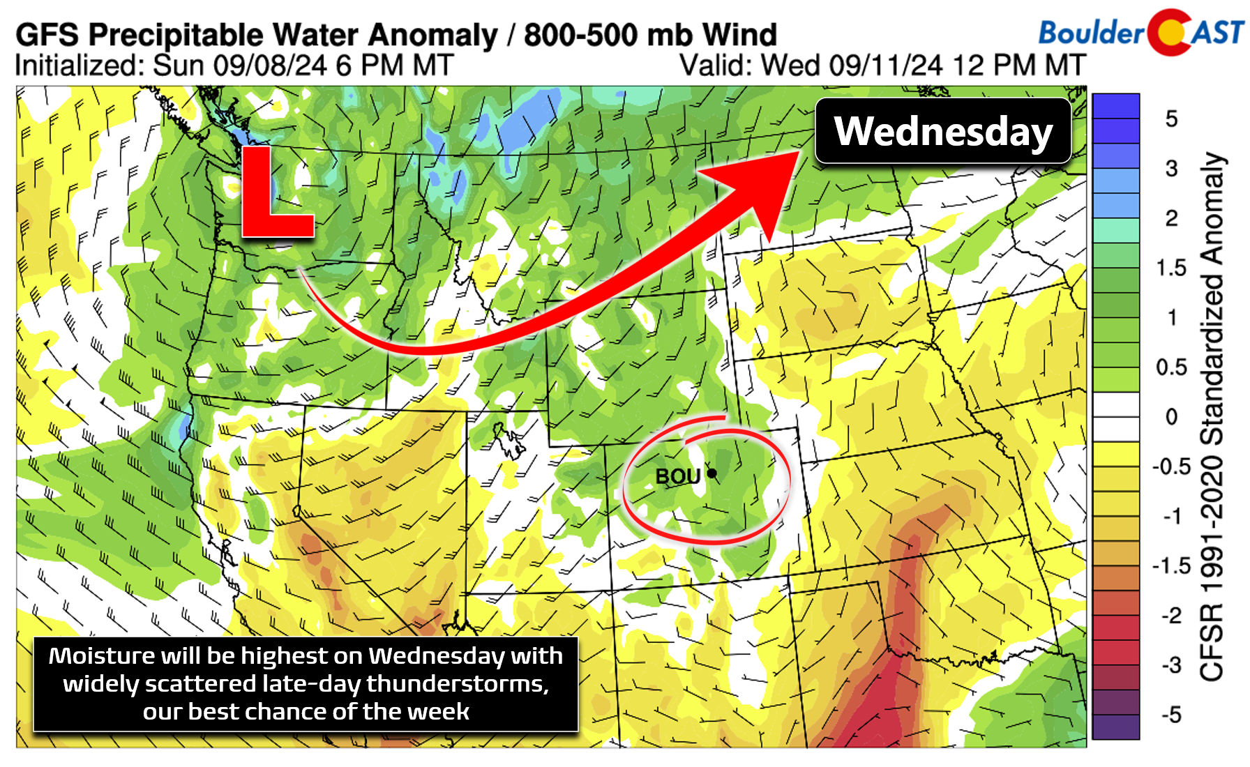
- Best Chance of Rain? Wednesday: Moisture levels peak on Wednesday and so too do our thunderstorm chances. Scattered PM storms are expected.
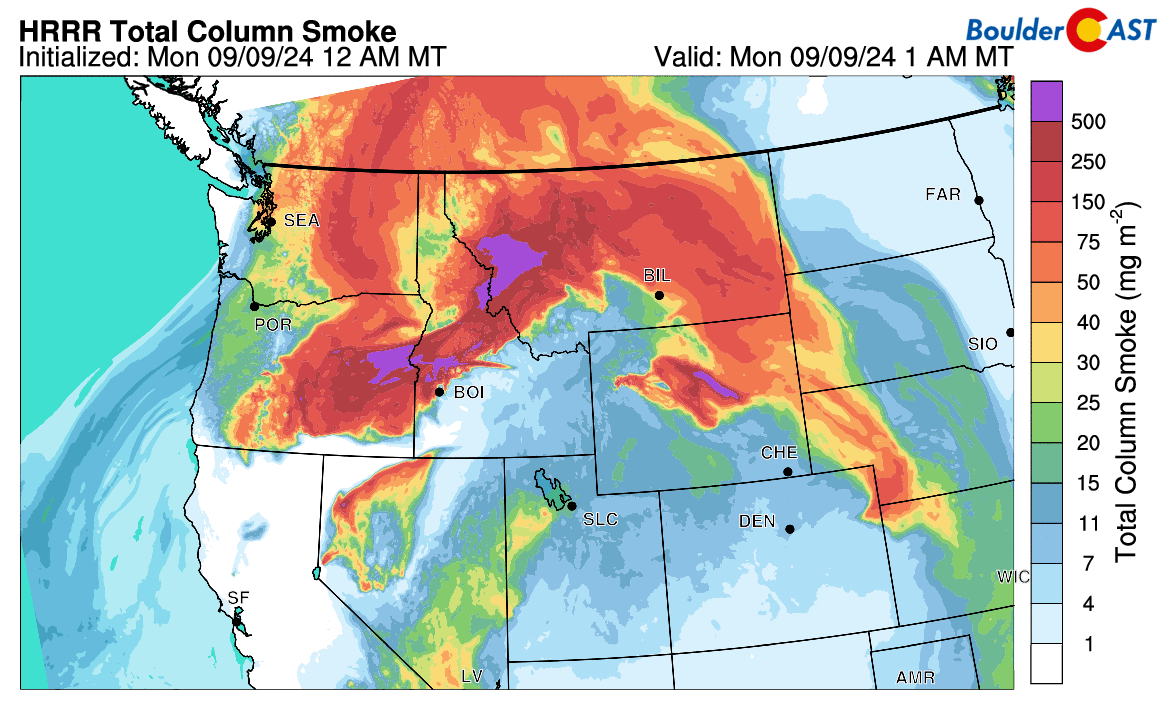
- Smoky At Times: Smoke for large and abundant wildfires burning in the Pacific Northwest will pulse intermittently across the Metro area this week leading to hazy skies at times.
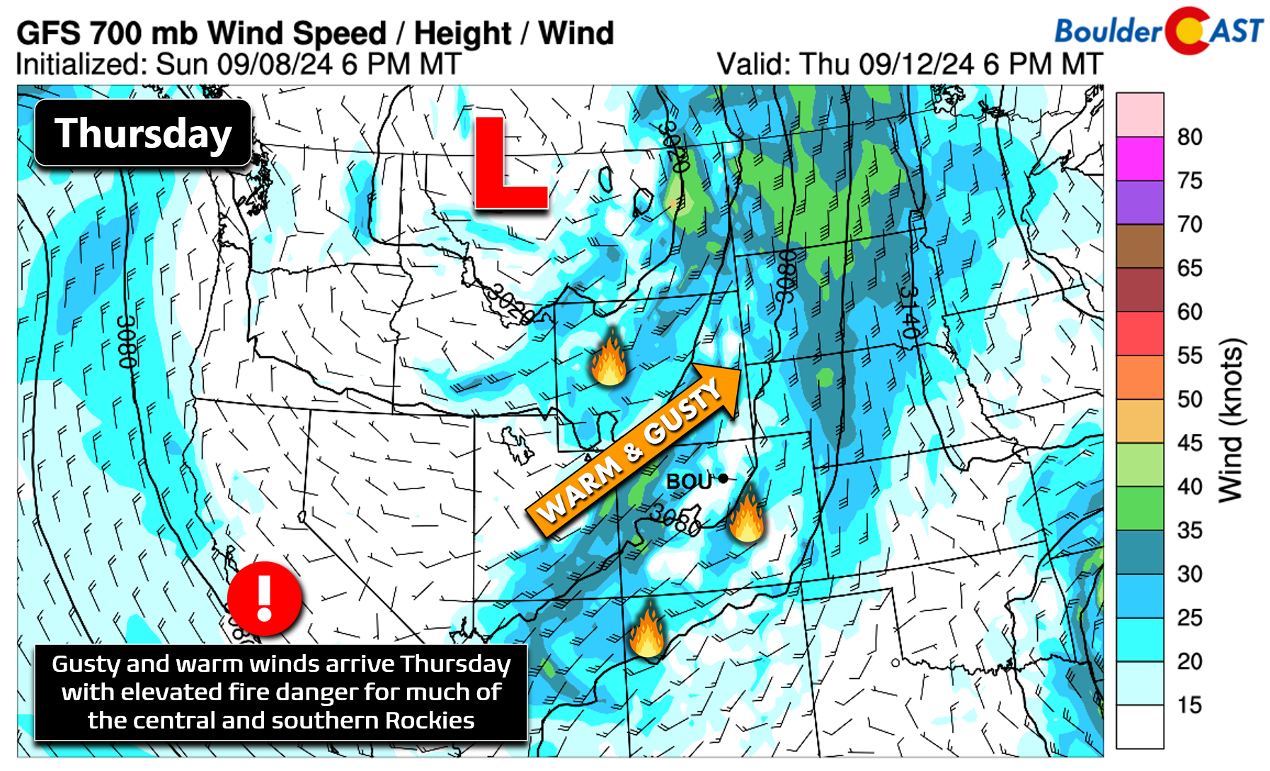
- Fire Danger Thursday: A strong trough will pass well north of Colorado late week. The precipitation and cold air will bypass the area, but increased winds and dry air will combine to raise fire danger.
- Drying Out Friday & Beyond: Very dry air will be over the Front Range late-week behind the departing trough leading to dry conditions for the weekend ahead.
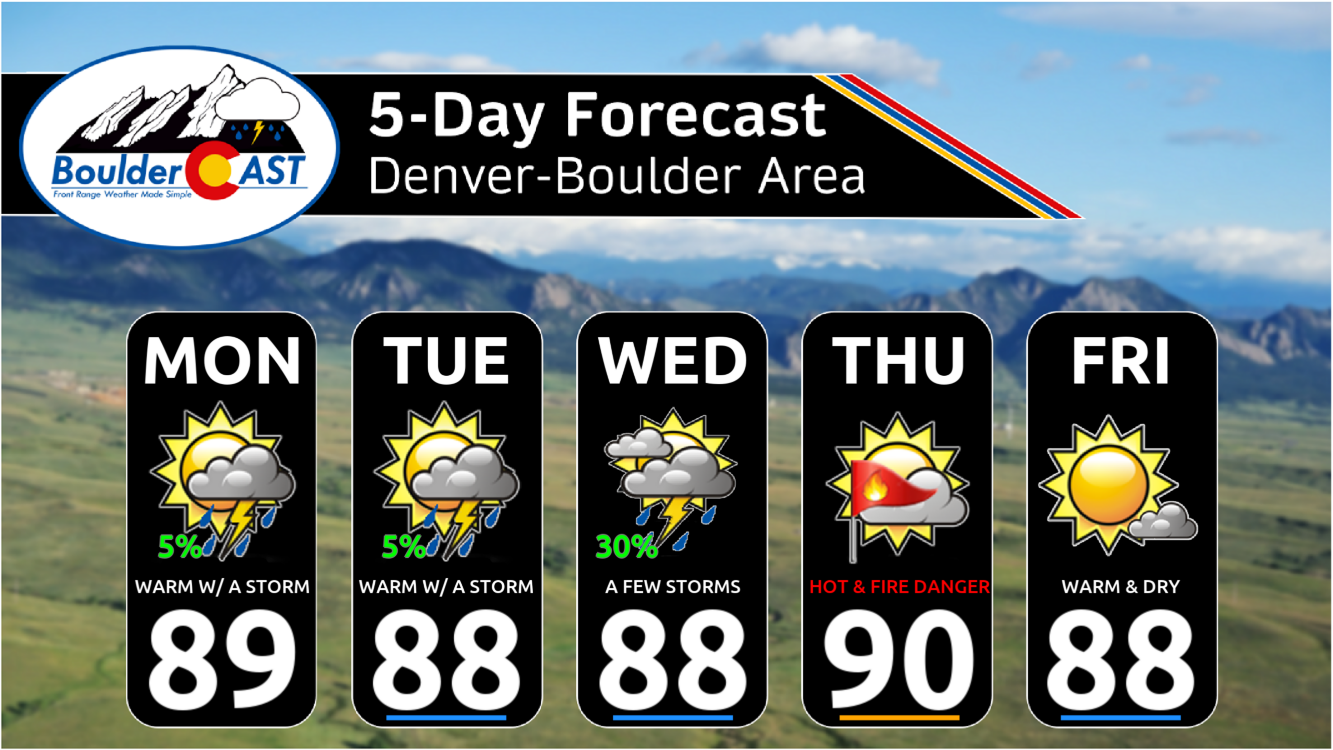
- Hot & Steady Temps: Temperatures will fluctuate very little this week with upper 80s to lower 90s every day through Saturday.
DISCLAIMER: This weekly outlook forecast is created Monday morning and covers the entire upcoming week. Accuracy will decrease as the week progresses as this post is NOT updated. To receive daily updated forecasts from our team, among many other perks, subscribe to BoulderCAST Premium.

Go Premium, get all the perks.
Daily Forecast Updates
Get our daily forecast discussion every morning delivered to your inbox.
All Our Model Data
Access to all our Colorado-centric high-resolution weather model graphics. Seriously — every one!
Ski & Hiking Forecasts
6-day forecasts for all the Colorado ski resorts, plus more than 120 hiking trails, including every 14er.
Smoke Forecasts
Wildfire smoke concentration predictions up to 72 hours into the future.
Exclusive Content
Weekend outlooks every Thursday, bonus storm updates, historical data and much more!
No Advertisements
Enjoy ad-free viewing on the entire site.
Hot & mostly dry this week
The weather this week in the Front Range will be greatly influenced by a fleeting ridge of high pressure early on, with some mid-level moisture available for storm development. Towards the mid to latter part of the week, a potent trough will approach the area from the Pacific Northwest bringing changes to our weather, though most models tend to stall and redirect this system northward before it can fully infiltrate eastern Colorado. Both the early week ridge and the late week Pacific trough are shown in the European ensemble 500mb height anomaly forecast animation below.
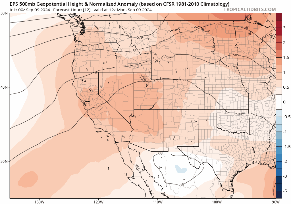
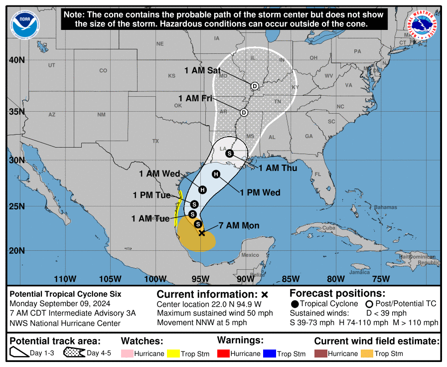
The animation above also shows the landfall of what is likely to be a weak hurricane named Francine into Louisiana Wednesday night. It was widely predicted that the 2024 Atlantic hurricane season would be extremely active and potentially record-breaking in many aspects. That bold fortelling hasn’t materialized yet, but we still have several more months to go when ocean waters will be warm enough for tropical development, and right now (early to middle September) is usually the peak of activity in the Atlantic Basin.
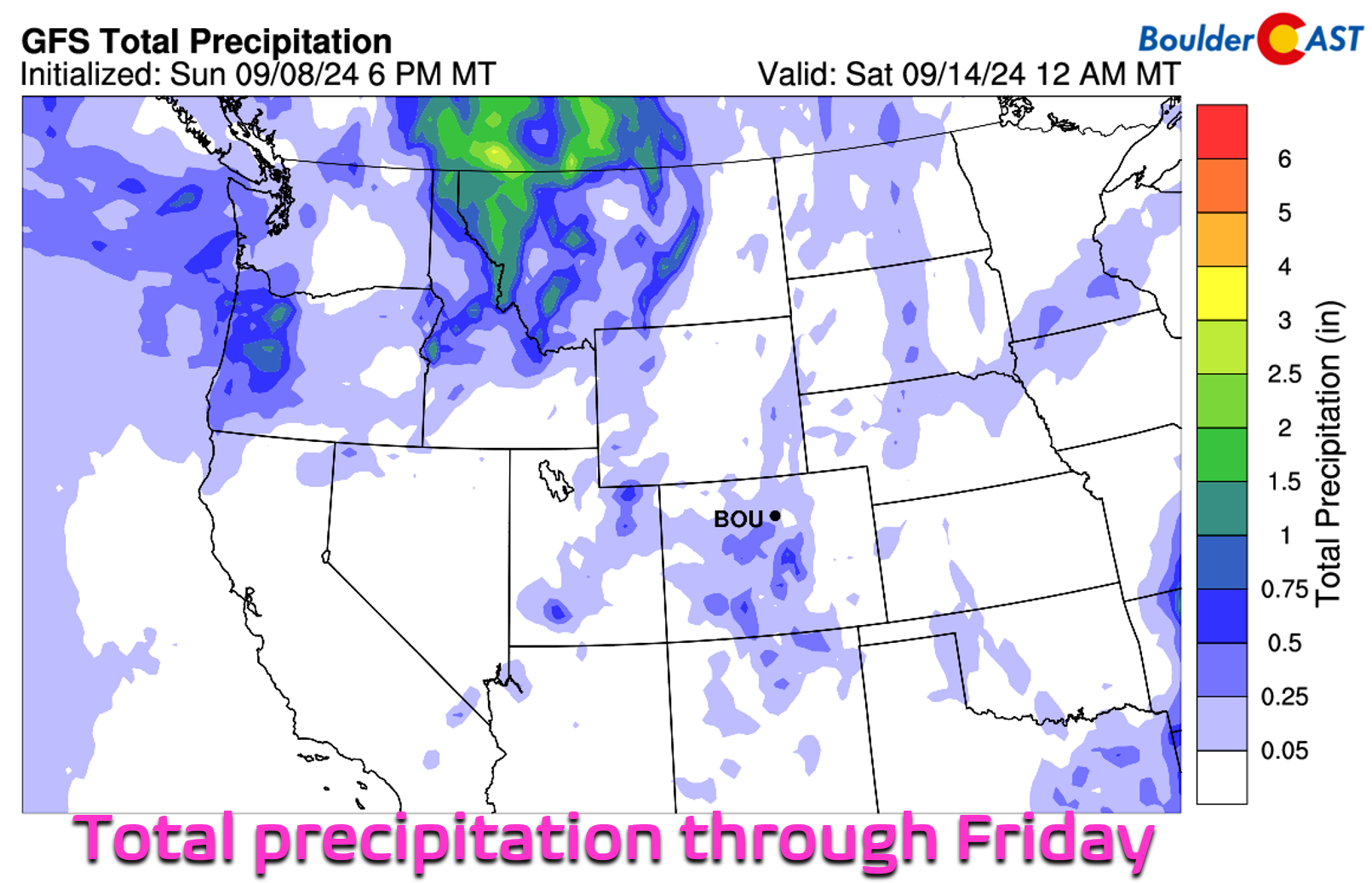
As mentioned, the early week period for us will have just enough moisture for a few storms to spawn underneath the ridge and westerly flow aloft. The late-week trough will largely miss Colorado to the north, instead only ushering in a plethora of dry air and gusty southwest winds as it scoots past. This will create at least one day of elevated fire danger in the Front Range. This is the WORST kind of trough!
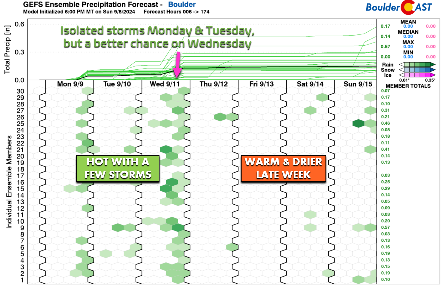
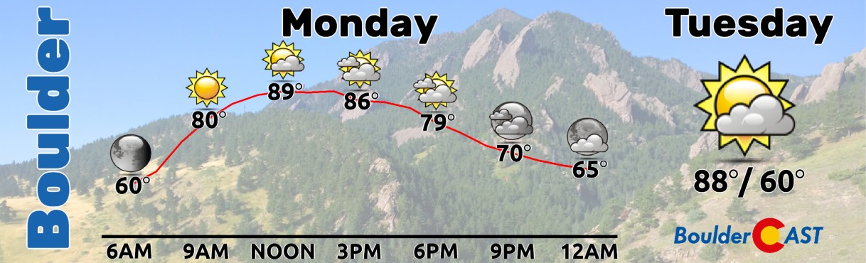
Both Monday and Tuesday will offer isolated, high-based thunderstorms in the Metro area capable of producing little to no rainfall but some gusty winds. Temperatures will top out in the upper 80s to near 90 degrees both days. The chance of picking up measurable rain for us Monday and Tuesday is only ~5% each day, too low for our day planner graphic to even show any hints of rain:
Skies will be hazy early in the week thanks to an influx of wildfire smoke originating largely from Oregon and Idaho. Most of the smoke will be elevated in the atmosphere which means our mountain views will be rather restricted, but our air quality should remain okay.
Wednesday will bring our best chance of rain for the week, but only around 20-30% odds as moisture spikes across the area well out ahead of the trough. There’s not really any energy available to organize the storms unfortunately. These will just be diurnally-forced, with the lingering late-summer sun taking advantage of the uptick in moisture. Temperatures on Wednesday will stay warm in the upper 80s.
As we head into the late-week, the potent trough will move further east through Idaho and into Montana which will usher in dry and moderately strong flow to Colorado from the southwest. This will bring warm, dry and gusty conditions for our Thursday. You know what the means — fire risk will be a concern! Critical fire danger will almost certainly exist across the Palmer Divide and areas east of Denver. Our immediate area is a bit less certain, but at best we can expect somewhat elevated fire danger here. Winds will be lighter on Friday as the trough moves further northeast into Canada, but there may still be some lingering fire concerns for far eastern Colorado.
As the trough moves through and departs late in the week, temperatures will stay in the upper 80s to near 90 degrees — there really isn’t going to be a discernible cold front with this trough — at least anything this far south. In fact, we’re expecting very little fluctuation in our temperatures throughout the entire week ahead, with most days landing between 88 and 91 degrees — well above seasonal normals for this time of year which are in the upper 70s.
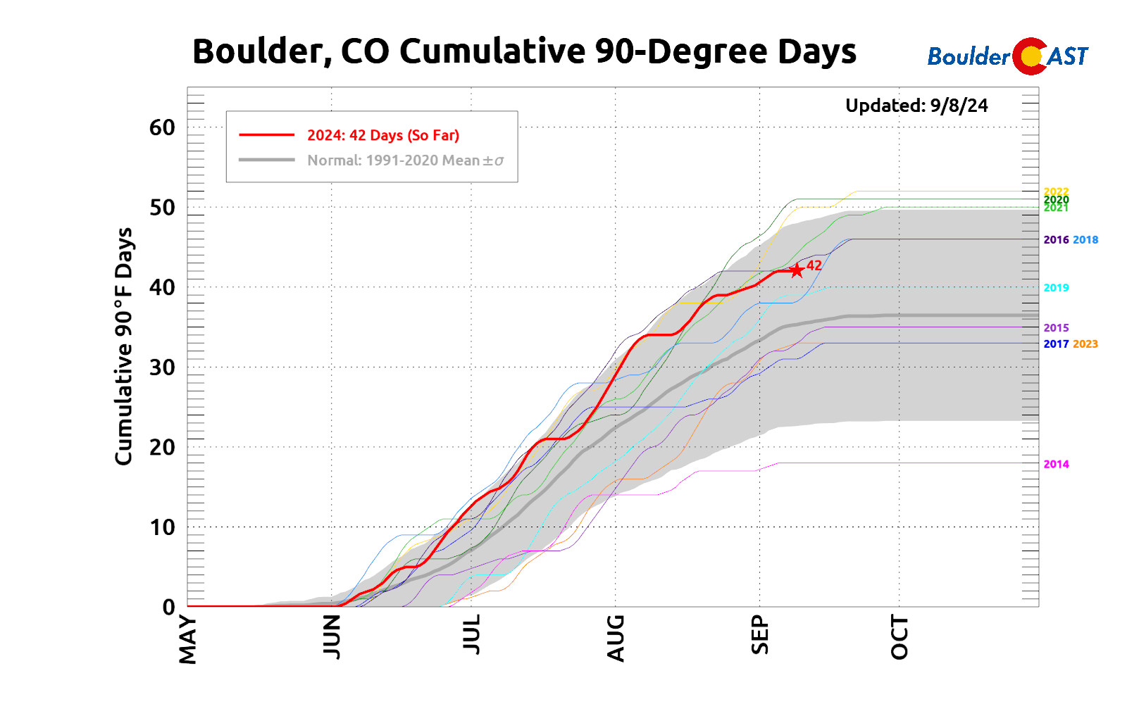
Boulder is up to 42 90-degree days this year and the week ahead perhaps could up that total by one or two…
As we discussed last week, drought is expected to worsen across the Front Range in the coming weeks and months with a dry and warm autumn about to unfold. This week’s meager dose of rainfall certainly won’t help refute that projection. Warm and dry conditions will persist into the upcoming weekend with temperatures staying around 90 degrees. Both Saturday and Sunday are likely to be entirely dry as well.
We’ll end this week’s forecast with a relaxing scene captured from Rampart Reservoir yesterday. Enjoy the week!
Forecast Specifics:
Monday: Morning sun giving way to partly cloudy skies later in the day with a very slight chance of isolated thunderstorms. Storms will produce gusty winds but little to no rainfall. High temperatures will top out in the upper 80s on the Plains with middle 70s in the Foothills.
Tuesday: Morning sun giving way to partly cloudy skies later in the day with a very slight chance of isolated thunderstorms. Storms will produce gusty winds but little to no rainfall. High temperatures will top out in the upper 80s on the Plains with middle 70s in the Foothills.
Wednesday: Partly to mostly cloudy and warm with widely scattered afternoon and evening thunderstorms. High temperatures in the mid to upper 80s on the Plains with middle 70s in the Foothills.
Thursday: Hot and dry with elevated fire danger due to gusty south-southwest winds and humidity below 15%. Temperatures will soar close to 90 degrees on the Plains, with upper 70s in the Foothills.
Friday: Mostly sunny and warm with temperatures in the upper 80s on the Plains and middle 70s in the Foothills. Fire danger should be lower but could linger in some eastern areas, depending on how the forecast evolves.
Weekend: Staying warm and mostly dry with temperatures in the upper 80s to near 90 degrees. A slight chance of storms may return by Sunday, but probably not.
Get BoulderCAST updates delivered to your inbox:
DISCLAIMER: This weekly outlook forecast is created Monday morning and covers the entire upcoming week. Accuracy will decrease as the week progresses as this post is NOT updated. To receive daily updated forecasts from our team, among many other perks, subscribe to BoulderCAST Premium.
Go Premium, get all the perks.
Daily Forecast Updates
Get our daily forecast discussion every morning delivered to your inbox.
All Our Model Data
Access to all our Colorado-centric high-resolution weather model graphics. Seriously — every one!
Ski & Hiking Forecasts
6-day forecasts for all the Colorado ski resorts, plus more than 120 hiking trails, including every 14er.
Smoke Forecasts
Wildfire smoke concentration predictions up to 72 hours into the future.
Exclusive Content
Weekend outlooks every Thursday, bonus storm updates, historical data and much more!
No Advertisements
Enjoy ad-free viewing on the entire site.
Enjoy our content? Give it a share!


You must be logged in to post a comment.