Last week’s cold front didn’t just drop temperatures—it dragged in a wall of chemical-scented smoke that turned the Front Range skies hazy and acrid. The days ahead are shaping up to be much more pleasant with warmer temps, limited storm chances, and a break from the smoke (at least for now) under southwest flow. Read on for a full breakdown of this week’s weather, including when to expect the best shot at rain and whether any smoke may return in the extended.
This week’s highlights include:
🌫️ Cold Front Delivered Smoke, Not Just Cool Air: Last Thursday’s front ushered in thick wildfire smoke from western Canada and the Pacific Northwest, sharply reducing visibility and air quality across the Front Range.
🧪 Chemical Scent Explained by Atmospheric Chemistry: The acrid, plastic-like smell of the smoke came from VOCs breaking down during long-distance transport, leaving behind compounds like benzene and formaldehyde — a process we saw after the Marshall Fire too.
🔥 Smoke-Free Stretch Thanks to Southwest Flow: Despite ongoing wildfires, a protective southwest wind pattern will keep Colorado mostly clear of smoke through midweek, with only a slight chance of California smoke sneaking in later.
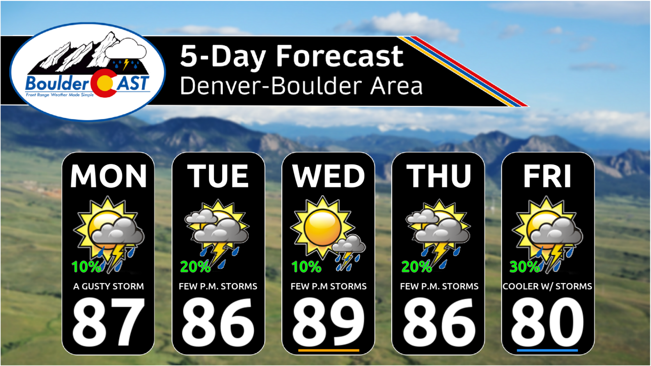
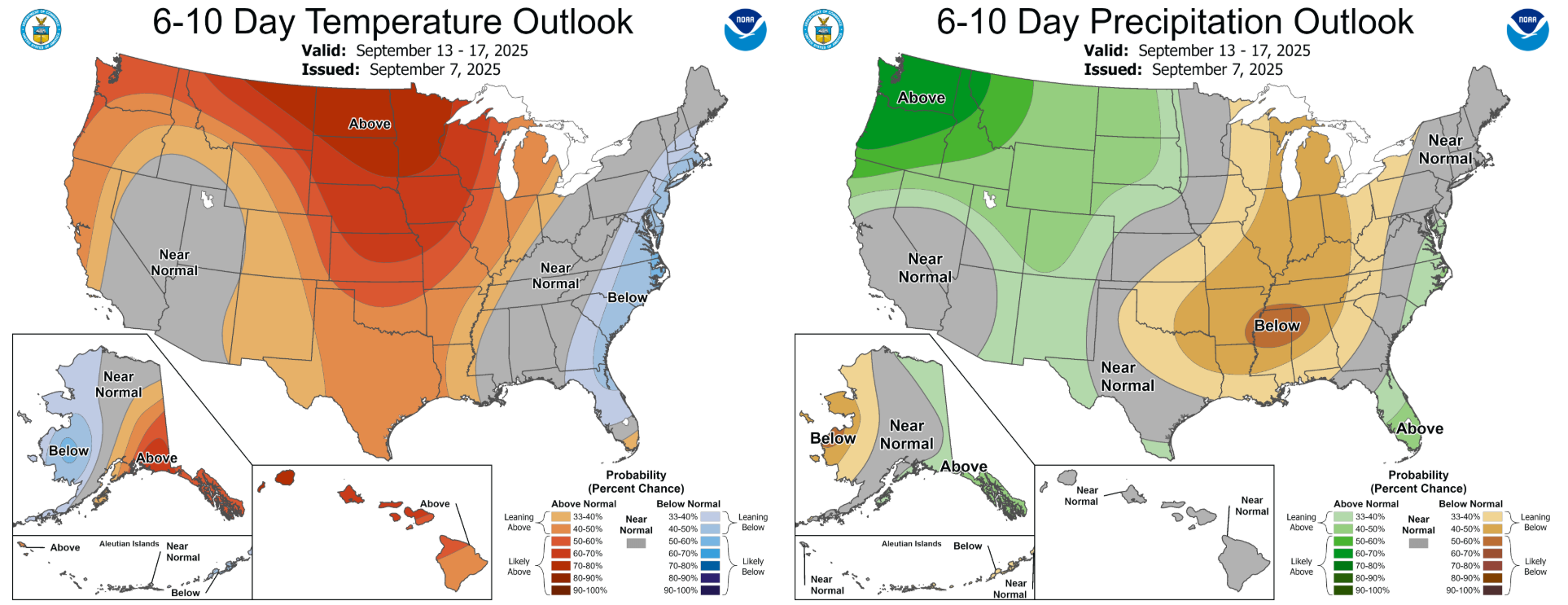
🌡️ Warm Week Ahead with Above-Normal Temps: A ridge of high pressure will push highs into the mid to upper 80s — several degrees above early September norms — especially Tuesday through Thursday.
🌦️ Storms Possible, But Mostly Light and Spotty: Daily chances for gusty, brief showers exist, especially in the Mountains. Boulder–Denver will see limited rainfall, with Friday offering the best shot at scattered storms.
🌤️ Pleasant Weekend on Tap: After Friday’s rain chances, the weekend looks warm and mostly dry, with highs in the low 80s and just a few leftover storms Saturday. Sunday should be ideal for outdoor plans.
DISCLAIMER: This weekly outlook forecast is created Monday morning and covers the entire upcoming week. Accuracy will decrease as the week progresses as this post is NOT updated. To receive daily updated forecasts from our team, among many other perks, subscribe to BoulderCAST Premium.

Go Premium, get all the perks.
Daily Forecast Updates
Get our daily forecast discussion every morning delivered to your inbox.
All Our Model Data
Access to all our Colorado-centric high-resolution weather model graphics. Seriously — every one!
Ski & Hiking Forecasts
6-day forecasts for all the Colorado ski resorts, plus more than 120 hiking trails, including every 14er.
Smoke Forecasts
Wildfire smoke concentration predictions up to 72 hours into the future.
Exclusive Content
Weekend outlooks every Thursday, bonus storm updates, historical data and much more!
No Advertisements
Enjoy ad-free viewing on the entire site.
Last week’s chemical-scented smoke
Last Thursday’s well-advertised cold front brought cooler temperatures but also a thick wall of wildfire smoke into the Front Range. The smoke largely originated from wildfires burning in western Canada, but some smoke from the Pacific Northwest was also mixed in.
Smoke forecast from last week showing the blast of smoke blowing south into Colorado from Canada
Things rapidly deteriorated as the front blew across the area Thursday evening, with visibility and air quality tanking as a result.
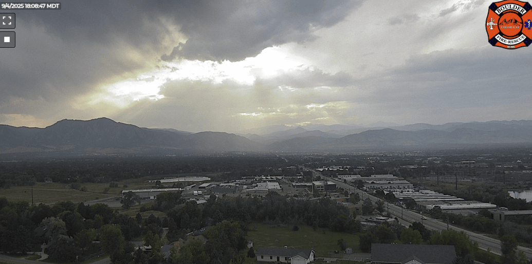
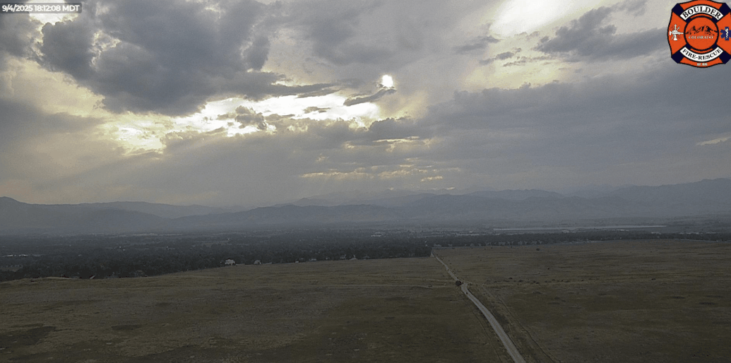
Timelapses of the smoke front blowing through Thursday evening in Boulder
The smoke-ridden air immediately following the cold front ushered in the worst air quality we’ve seen in 2025, with PM2.5 Air Quality Indices soaring up to 180 in some areas:
Luckily the Unhealth for Everyone (150+) air only stuck around for a couple of hours behind the front:
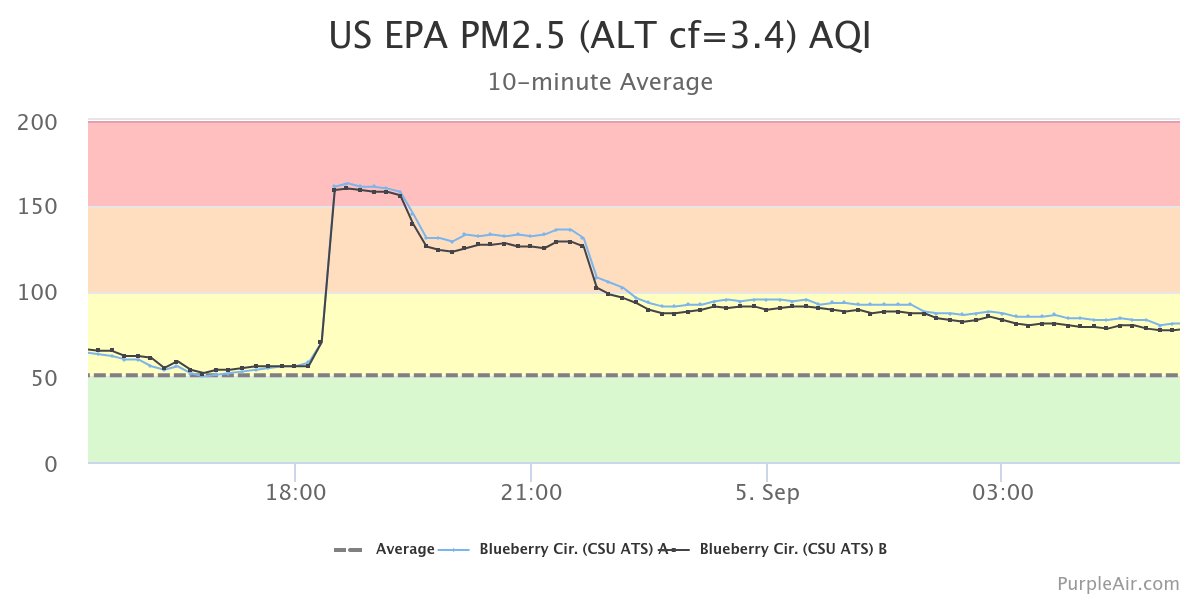
Timeline of PM2.5 air quality from Fort Collins last Thursday evening. The worst 150+ AQIs only lasted 1-2 hours.
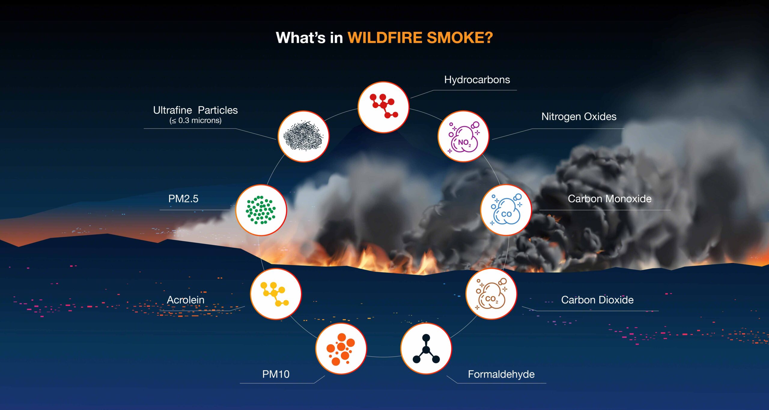
One thing you may have noticed last week was that the smoke smelled more like chemicals than a cozy campfire. That’s not your nose playing tricks — it was chemistry at work.
When wood and other vegetation burn, they release a mix of gases called volatile organic compounds (VOCs). Some of these VOCs give off that familiar smoky, woodsy aroma. But as the smoke travels through the atmosphere over several days and hundreds of mile, sunlight — specifically UV radiation — starts breaking down those scent-producing molecules.
What’s left behind are the tougher, longer-lasting compounds like benzene, formaldehyde, and acrolein. These hang around in the air much longer and have a sharper, more acrid smell — which is why distant wildfire smoke often carries more of a plastic or rubber scent — and was exactly what happened in last week’s wall of smoke. We saw this chemical reaction play out after the Marshall Fire, too. Homes that survived the flames but got hit with thick smoke absorbed those lingering compounds, creating in-home air quality concerns long after the fire was out and the smoky smell was gone.
Warming Weather Ahead
Temperatures will keep climbing early this week as a ridge of high pressure builds in from the west. That ridge sets up over western Colorado Monday, parks itself over Boulder Tuesday, and then shifts eastward by midweek. The result? A steady stream of warm southwest flow that keeps us running a few degrees above normal through Thursday.
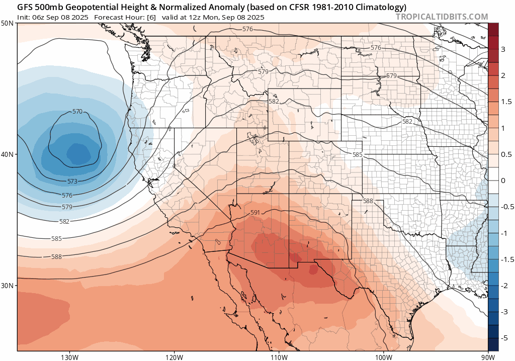
GFS 500mb height anomaly forecast animation for this week
Expect highs in the mid to upper 80s — a solid notch above our early September climatology which is in the lower 80s.

Storm Chances: There, But Limited
That southwest flow is dragging in a bit of late-season monsoon moisture, which means we’ll see daily chances for showers and thunderstorms. But don’t count on a soaking. Much like this past weekend, low-level moisture is lacking east of the Continental Divide, so most storms will be brief, gusty, and light on rainfall.
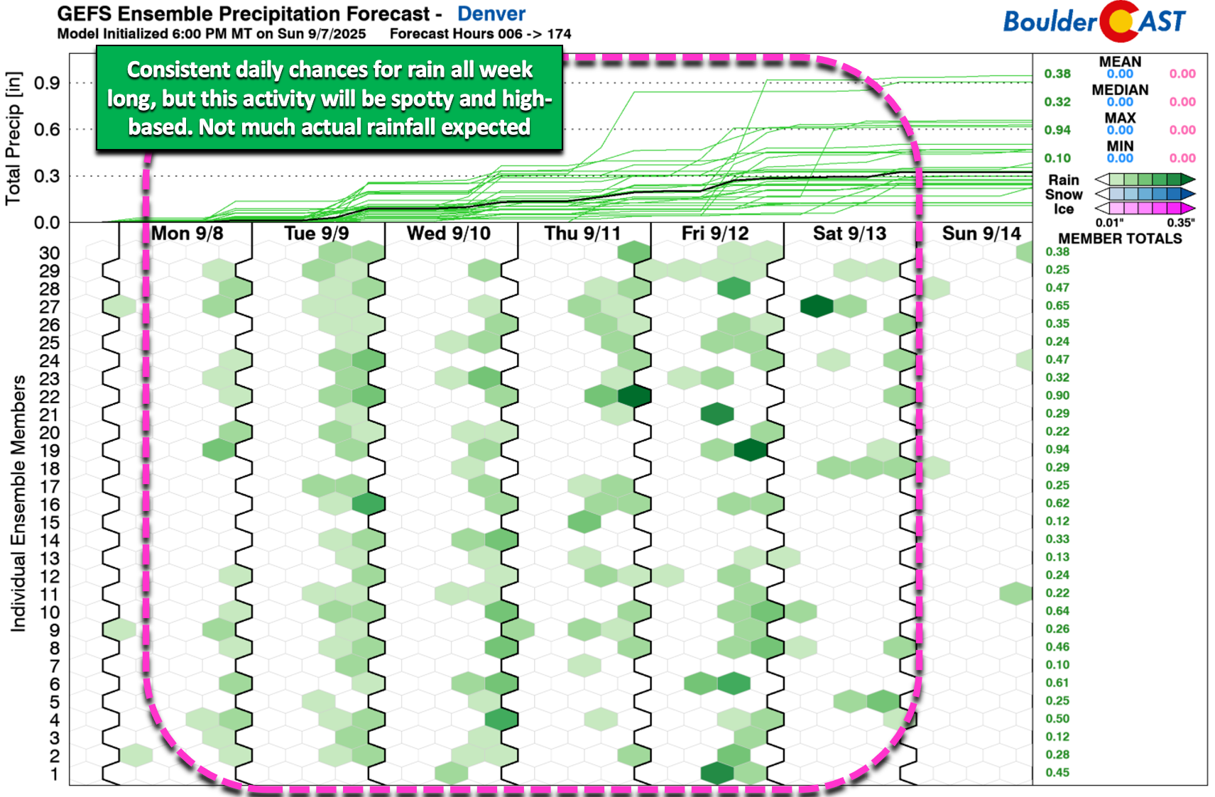
Mountain zones — especially the San Juans — could pick up 0.5″ to 1.0″ of rain through the week. Meanwhile, the Boulder–Denver corridor will be lucky to a fraction of that. Most afternoons will feature ominous skies with isolated to scattered storms, but there’ll be plenty of dry time to go around this week.
A Largely Smoke-Free Week
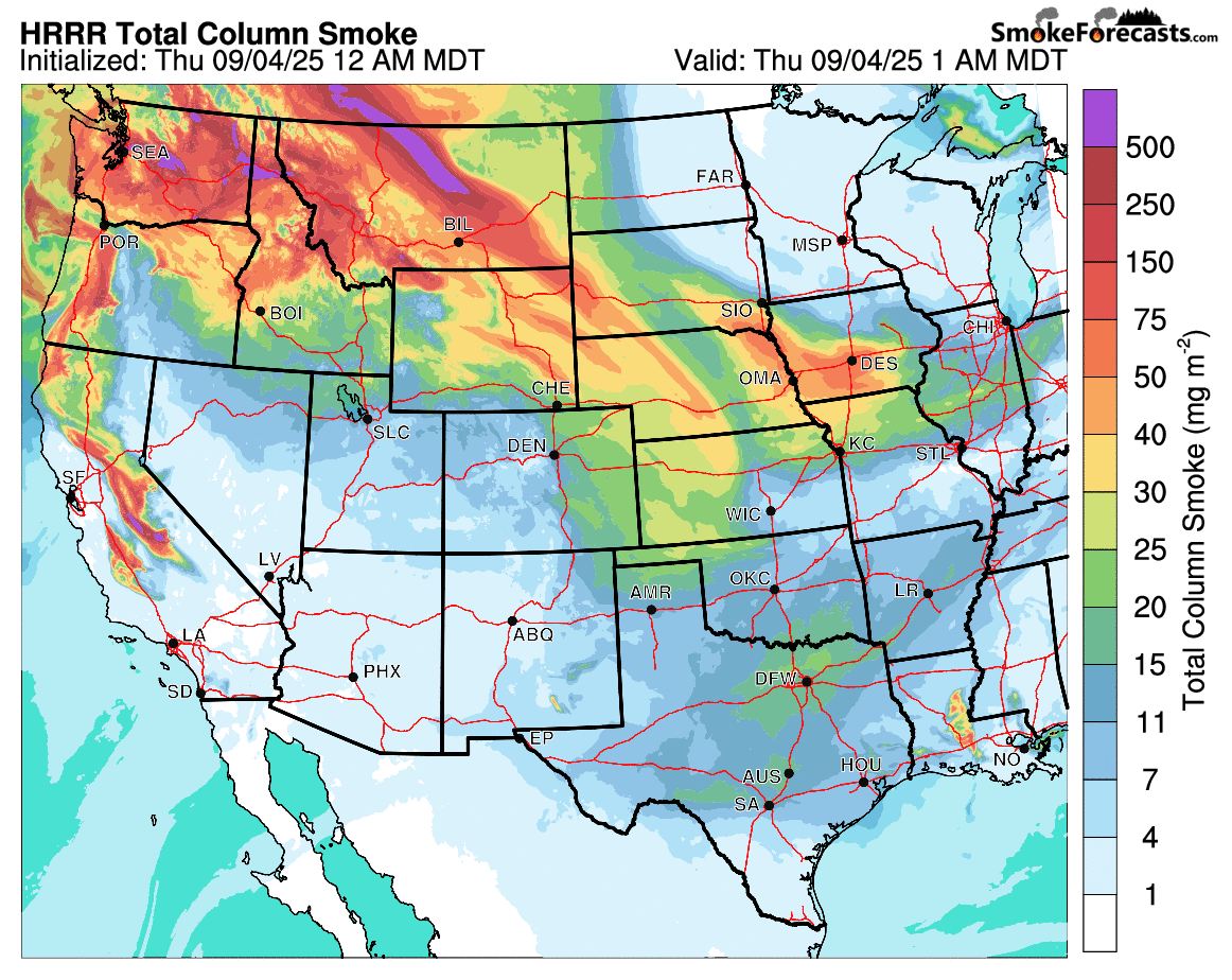
Those big wildfires that sent smoke our way last week are still burning strong across Canada, the Pacific Northwest, and California. The only reason we got a break on Sunday was thanks to a helpful shift in the winds.
The good news: this week’s southwest flow will act like a shield, keeping most of that thick, smelly smoke bottled up to our north. We should stay mostly clear of smoke through at least Wednesday.
However, later in the week, as a trough swings through, there’s a small chance some smoke sneaks back in — but if it does, it’ll likely be from California rather than Canada. For now, the overall smoke risk looks low and the details are still fuzzy this far out.
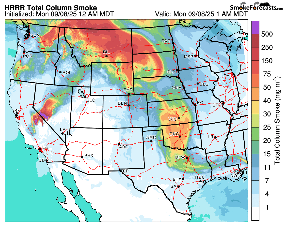
Smoke forecast for Monday and Tuesday. Colorado remains mostly clear due to SW flow keeping the smoke at bay.
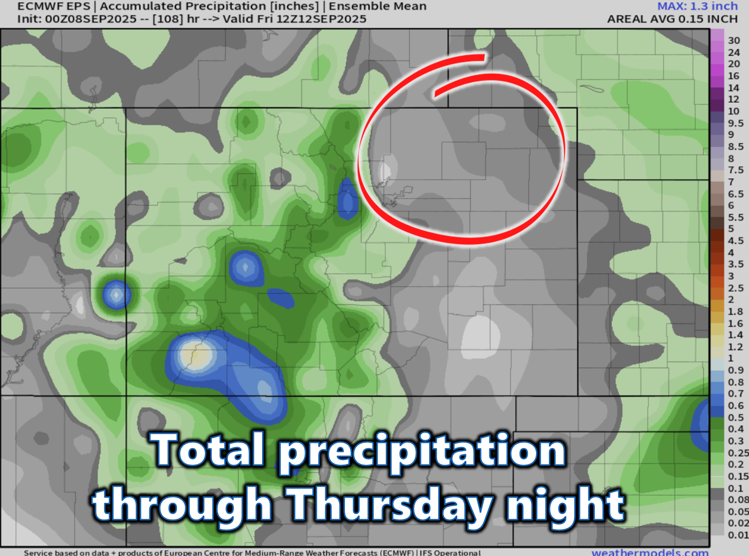
Rain Chances Spike Friday
The best shot at more widespread rain comes late Thursday into Friday, when a weak trough clips northwest Colorado. This system may enhance lift statewide, especially with a jet streak nearby and a brief bump in moisture. That said, we’re still watching for lingering dry air east of the Mountains, and without a strong cold front, surface moisture will remain limited.
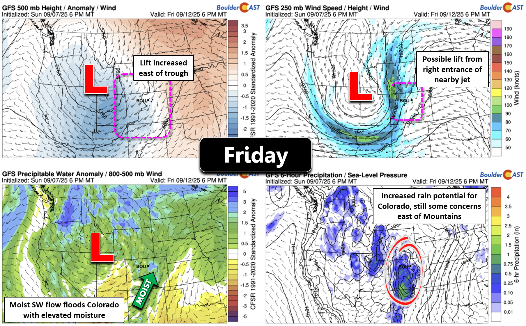
Still, Friday looks like our best bet for scattered to numerous storms — and a modest cooldown, with highs dipping to around 80°F.
Weekend Remains Pleasant
As the trough exits northeast, the weekend shapes up nicely. A few leftover storms could pop Saturday, but Sunday should be dry and warm, with highs holding in the low 80s.
Bottom Line
Overall, it will be a fairly warm week with just low-end storm chances. Don’t cancel any outdoor plans — just keep an eye to the sky each afternoon for the chance of a quick-hitting gusty shower or thunderstorm. The best chance of rain on any given day will be across the higher terrain of the Mountains, Foothills, and Palmer Divide.
Try to enjoy what should be a warm but lovely late-summer week in the Front Range — autumn is not far off at all…
Forecast Specifics:
Monday: Morning sun with increasing clouds. One or two weak storms may move through by afternoon and evening with gusty winds the main risk. Highs in the middle 80s for the Plains with middle 70s in the Foothills.
Tuesday: Partly to mostly cloudy with widely scattered late-day gusty storms. Highs will again be in the middle 80s for the Plains with middle 70s in the Foothills.
Wednesday: Warmer with more sunshine. A few clouds and isolated high-based storms may move off the higher terrain late in the day, but the chance of rain is low. Highs top out in the upper 80s to lower 90s on the Plains with upper 70s in the Foothills.
Thursday: Staying warm. Morning sun will give way to increasing late-day clouds and widely scattered storms. The best chance will be over the higher terrain. Highs reach the middle 80s on the Plains with lower 70s in the Foothills.
Friday: Likely the best chance of rain for the week as a trough passes nearby. Widespread storms are expected in the Mountains, with scattered late-day storms for the Boulder-Denver area. Storms will still be limited by low-level moisture making rainfall potential not great and outflow winds still the big concern. Highs drop to near 80° on the Plains with upper 60s in the Foothills.
Weekend: Trending drier with highs in the lower 80s or so. A slight risk of a few storms on Saturday, but Sunday should be mostly dry.
DISCLAIMER: This weekly outlook forecast is created Monday morning and covers the entire upcoming week. Accuracy will decrease as the week progresses as this post is NOT updated. To receive daily updated forecasts from our team, among many other perks, subscribe to BoulderCAST Premium.
Go Premium, get all the perks.
Daily Forecast Updates
Get our daily forecast discussion every morning delivered to your inbox.
All Our Model Data
Access to all our Colorado-centric high-resolution weather model graphics. Seriously — every one!
Ski & Hiking Forecasts
6-day forecasts for all the Colorado ski resorts, plus more than 120 hiking trails, including every 14er.
Smoke Forecasts
Wildfire smoke concentration predictions up to 72 hours into the future.
Exclusive Content
Weekend outlooks every Thursday, bonus storm updates, historical data and much more!
No Advertisements
Enjoy ad-free viewing on the entire site.
Enjoy our content? Give it a share!


You must be logged in to post a comment.