This week’s weather in the Front Range will be a bit of a rollercoaster. After Sunday night’s soaking rain and snow, Monday kicks off with fog, drizzle, and stubborn clouds before a midweek warm-up brings back the sunshine. But don’t get too cozy: frost season is knocking on the door, and snow signals are starting to flicker in the long-range models. Read on for the full breakdown, including what to expect today, what time rain showers will return later in the day Monday, and when late-season gardeners should start watching for frost and snowflakes.
P.S. Don’t forget to submit your entry to our 2025 First Snow Contest which closes Tuesday night at midnight!
This week’s highlights include:
- 🌧️ Storm Moves Out: Sunday evening brought widespread rain and mountain snow to the western and northern Front Range, boosting moisture totals and further easing drought conditions east of the Divide.
- 🌫️ Foggy Start to Monday: Shallow upslope flow keeps patchy fog and drizzle around the Metro area on Monday, especially near the Foothills. Overcast skies persist, and highs only near 50°F.
- 🌦️ Afternoon Showers Return: A weak jet feature will spark banded showers again Monday afternoon and evening, mainly southeast of Boulder towards Denver. Expect lingering clouds into Tuesday morning.
- ☀️ Midweek Warm-Up: A ridge builds midweek, bringing dry, pleasant weather. Highs climb into the 70s and low 80s through Friday, with the next weak weather system possibly arriving late Sunday or Monday.
- 🥶 No Frost Yet, But Close: Despite the chilly weather at hand, low clouds and mild overnight temps (low to mid 40s) are preventing frost—for now. Boulder’s median first frost is October 6th, so gardeners should stay alert, especially next week.
- ❄️ Snow Chances Still Slim: No snow expected in the next 7–10 days, but climatology suggests that will be changing soon. Some long-range models even hint at snow next weekend.
- 🏆 Don’t forget to submit your entry to our 2025 First Snow Contest which closes Tuesday night at midnight!

DISCLAIMER: This weekly outlook forecast is created Monday morning and covers the entire upcoming week. Accuracy will decrease as the week progresses as this post is NOT updated. To receive daily updated forecasts from our team, among many other perks, subscribe to BoulderCAST Premium.

Go Premium, get all the perks.
Daily Forecast Updates
Get our daily forecast discussion every morning delivered to your inbox.
All Our Model Data
Access to all our Colorado-centric high-resolution weather model graphics. Seriously — every one!
Ski & Hiking Forecasts
6-day forecasts for all the Colorado ski resorts, plus more than 120 hiking trails, including every 14er.
Smoke Forecasts
Wildfire smoke concentration predictions up to 72 hours into the future.
Exclusive Content
Weekend outlooks every Thursday, bonus storm updates, historical data and much more!
No Advertisements
Enjoy ad-free viewing on the entire site.
Storm Recap: A wet Sunday night
Right on cue, bands of precipitation rolled in Sunday evening, targeting the western and northern Front Range. Showers kicked off around 5PM and stuck around past midnight in some areas—bringing a much-needed dose of moisture to nearly everyone.

Denver area radar animation spanning from Sunday 5PM to Monday 5AM.
Rainfall Rundown:
- Totals mostly ranged from 0.25″ to 0.5″ between Denver and Boulder.
- Foothill communities saw even more—some topping 0.75″.
- Southeast of Denver saw the least as expected, with less than 0.10″ recorded.

Front Range precipitation totals Sunday evening into early Monday
Higher up temperatures were cold enough for rain to change over to frozen precipitation, with snow levels dropping down as low as 7500 feet overnight (even below model projections). The area along Peak to Peak Highway and near Rocky Mountain National Park is dusted in white this morning. Wet snow accumulations up to 3″ occurred here, while the higher east facing peaks along the Continental Divide likely picked up double that amount.

Peak to Peak Highway near Lily Lake, 8900 feet

Rocky Mtn National Park Fall River Entrance, near Estes Park, 8000 feet
The mountains look much different this morning than they did a few days ago:
This moisture will further help things along in the Front Range, where recent rains and snow have brought some drought relief east of the Continental Divide. At this point, only a small patch of drought remains south of Denver. Drought conditions are improving, but remain dire across the Western Slope.

A cool & dreary start to the week
The storm system that brought a quick burst of rain and snow last night has now shifted off to the north and east. Monday morning’s GOES-West infrared satellite imagery shows the coldest cloud tops now stretched across Nebraska, Wyoming, and the Dakotas—while Colorado is trending drier.

GOES-West infrared satellite animation from Monday morning. And yes there are two tropical cyclones in the Eastern Pacific
But don’t expect blue skies just yet. Even with the main system pulling away, shallow upslope flow is still locked in across the lower elevations. The surface forecast map below shows high pressure over the Dakotas spinning clockwise, helping funnel that upslope into the Front Range.

This upslope setup will be strongest Monday morning, which means patchy fog and drizzle—especially between Boulder and Fort Collins in and near the Foothills. As the day goes on, the upslope will weaken and cloud bases should lift a bit, but skies will stay stubbornly overcast. Highs will struggle to escape the 40s, with most spots landing near 50°F or so.
Later on Monday, short-range models hint at another round of banded showers developing in response to a weak jet streak. This won’t be a repeat of Sunday night’s widespread rain—expect lighter, more scattered showers focused southeast of Boulder, closer to Denver. Timing looks to be after 3PM and lingering into the late evening.

HRRR model-simulated radar animation for Monday evening showing banded showers returning to the Metro area
After that, low clouds hang tough overnight into Tuesday morning, acting like a thermal blanket and keeping us frost-free for now. Lows will dip into the low to mid 40s. Skies gradually clear Tuesday, but temps stay below normal with highs rebounding into the low to mid 60s.

Midweek warm-up ahead
Once Tuesday’s gloom lifts, we’re in for a stretch of classic early October weather. A ridge of high pressure builds northward over Colorado and the High Plains, bringing dry and pleasant conditions Wednesday through Friday.

Euro ensemble 500mb height anomaly forecast through Friday evening showing a big ridge developing over Colorado and the Great Plains
Expect highs climbing into the mid 70s and even low 80s by week’s end. That warmth should hold into the weekend, with our next weak disturbance likely arriving late Sunday or Monday with cooler weather in-tow.
Where are the cold and snow?
Even with this week’s mild stretch ahead, we’re entering the part of fall where frost becomes harder to avoid. Boulder’s median first frost date is October 6th—yep, that’s today! We’re running a little late, but it doesn’t take much: a weak front and clear skies can easily drop us into the mid-30s.
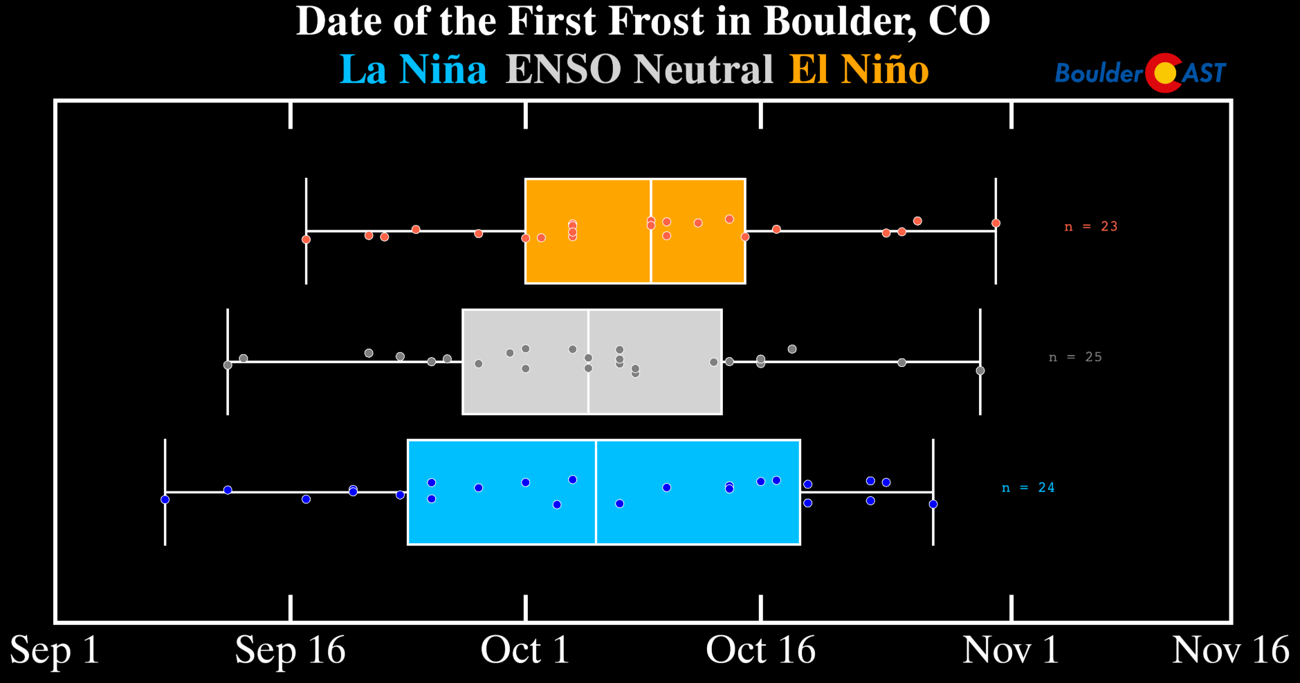
Fortunately the cool weather entrenched at the moment is accompanied by low clouds and upslope, preventing any clear sky frost for now. We don’t yet see a definitive push of cold air to develop frost, but climatology and the slightly cooler weather coming next week could be enough. Hopeful late-season gardeners should keep an eye on the overnight lows beginning early next week.

As for snow? The next 7–10 days look snow-free. Still, climatology tells us that by mid-October, any precipitation could start mixing with flakes.

Boulder’s median first accumulating snow date is October 20th, though the past four years have all been later than that.

Despite the bleak outlook for cold weather and snow in the short-term, snow enthusiasts need to keep a close watch on next weekend when ~30% of European ensemble forecast members have some snow across the Denver Metro area (during the October 17th to 21st period). There’s lots of variability across the modeling for late next week, so take this early signal of wintry weather with a big grain of salt!

That’s all for now. Enjoy the warming trend this week and don’t forget to submit your entry to our 2025 First Snow Contest 👇⬇️
 11th Annual First Snow Contest Closes Tuesday at 11:59 PM!
This is a community poll for the date you think the first MEASURABLE snowfall will occur in Boulder. Those who come closest to the actual date are the winners. For verification, we’ll go off the official Boulder climate station located at the NIST building in south Boulder.
The prizes for the contest are as follows:
- 1st place: 12-month Premium subscription + $35 Amazon Gift Card
- 2nd place: 6-month Premium subscription + $15 Amazon Gift Card
- Anyone who guesses within 1 day OR 0.1″ correct: 2-month Premium subscription
- All other entries: Virtual “pat on the back”

Forecast Specifics:
Monday: ?
Tuesday: ?
Wednesday: ?
Thursday: ?
Friday: ?
Weekend: ?
DISCLAIMER: This weekly outlook forecast is created Monday morning and covers the entire upcoming week. Accuracy will decrease as the week progresses as this post is NOT updated. To receive daily updated forecasts from our team, among many other perks, subscribe to BoulderCAST Premium.
Go Premium, get all the perks.
Daily Forecast Updates
Get our daily forecast discussion every morning delivered to your inbox.
All Our Model Data
Access to all our Colorado-centric high-resolution weather model graphics. Seriously — every one!
Ski & Hiking Forecasts
6-day forecasts for all the Colorado ski resorts, plus more than 120 hiking trails, including every 14er.
Smoke Forecasts
Wildfire smoke concentration predictions up to 72 hours into the future.
Exclusive Content
Weekend outlooks every Thursday, bonus storm updates, historical data and much more!
No Advertisements
Enjoy ad-free viewing on the entire site.
Enjoy our content? Give it a share!


You must be logged in to post a comment.