The entire upcoming week will feature well above average temperatures across the Front Range with several days of record highs up for grabs. There will be a couple of “cool-downs” behind dry cold fronts but temperatures will still remain above seasonal normals on those days as well. While the upcoming week is expected to be totally dry, there are some hints of a return to a more active and unsettled pattern next week. We’ll discuss this and more in our weekly outlook so read on!
This week’s highlights include:
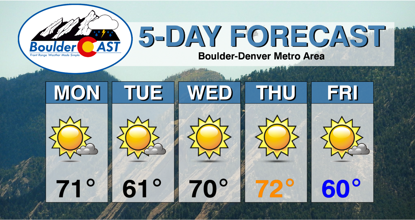
- Monday’s temperatures to rise into the lower 70s
- A brief “cool-down” Tuesday but still above seasonal normals
- Record highs possible Wednesday and Thursday in the upper 60s to middle 70s
- The week will be completely dry but there are hints of a more active pattern next week
DISCLAIMER: This weekly outlook forecast is created Monday morning and covers the entire upcoming week. Accuracy will decrease as the week progresses as this post is NOT updated. To receive daily updated forecasts from our team, subscribe to BoulderCAST Premium.

Dry and above average for the week
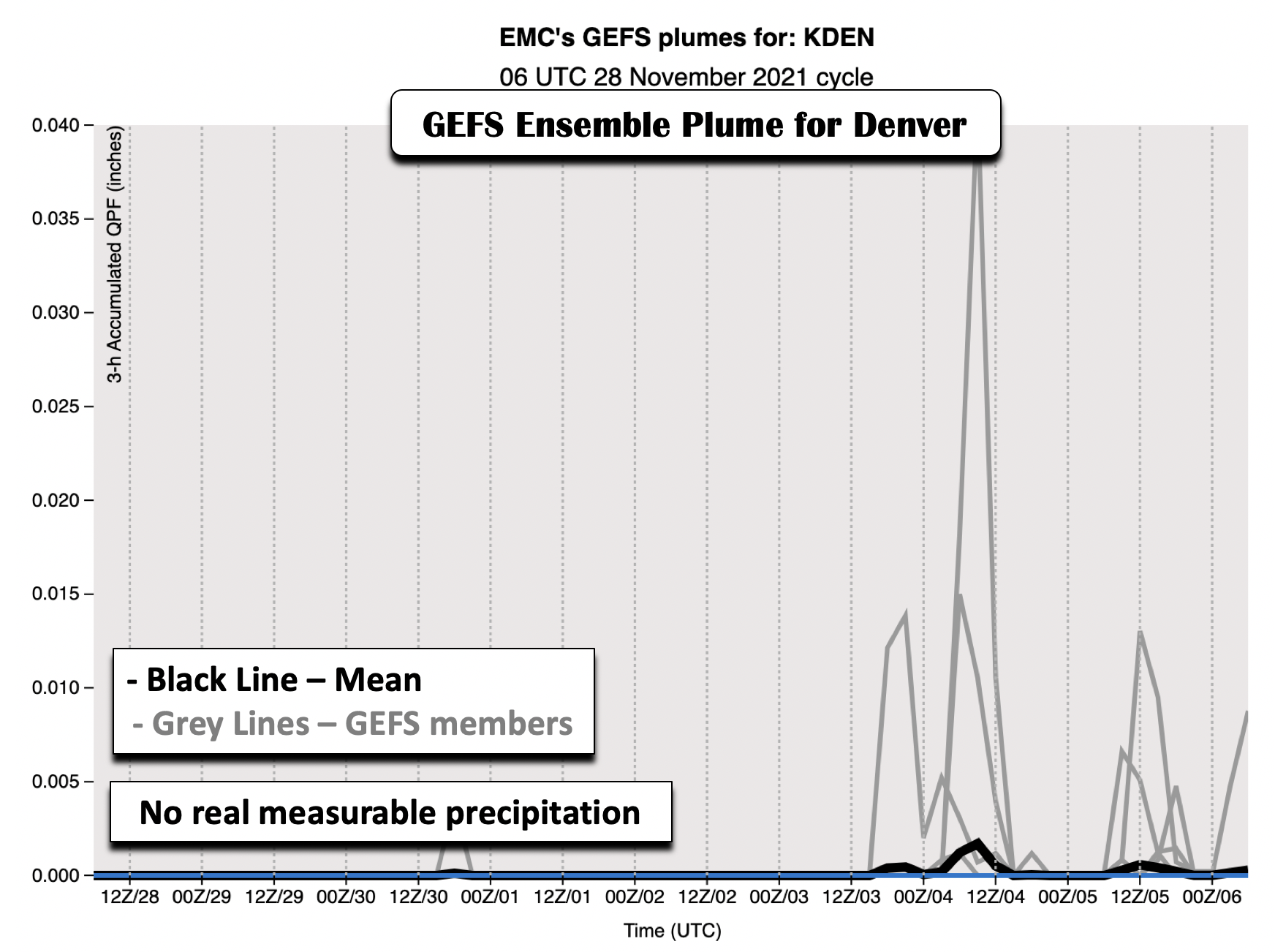
The weekly forecast for the Denver Metro area this week will be rather uneventful with no real precipitation chances and temperatures staying well above seasonal normals through the period. The figure below shows the GEFS ensemble plume for Denver, showing predicted precipitation amounts through the upcoming weekend. The grey lines are individual ensemble members, while the average of all members is in black. While there are some members which show a few hundredths of an inch of precipitation by the weekend, the mean is very close to zero.
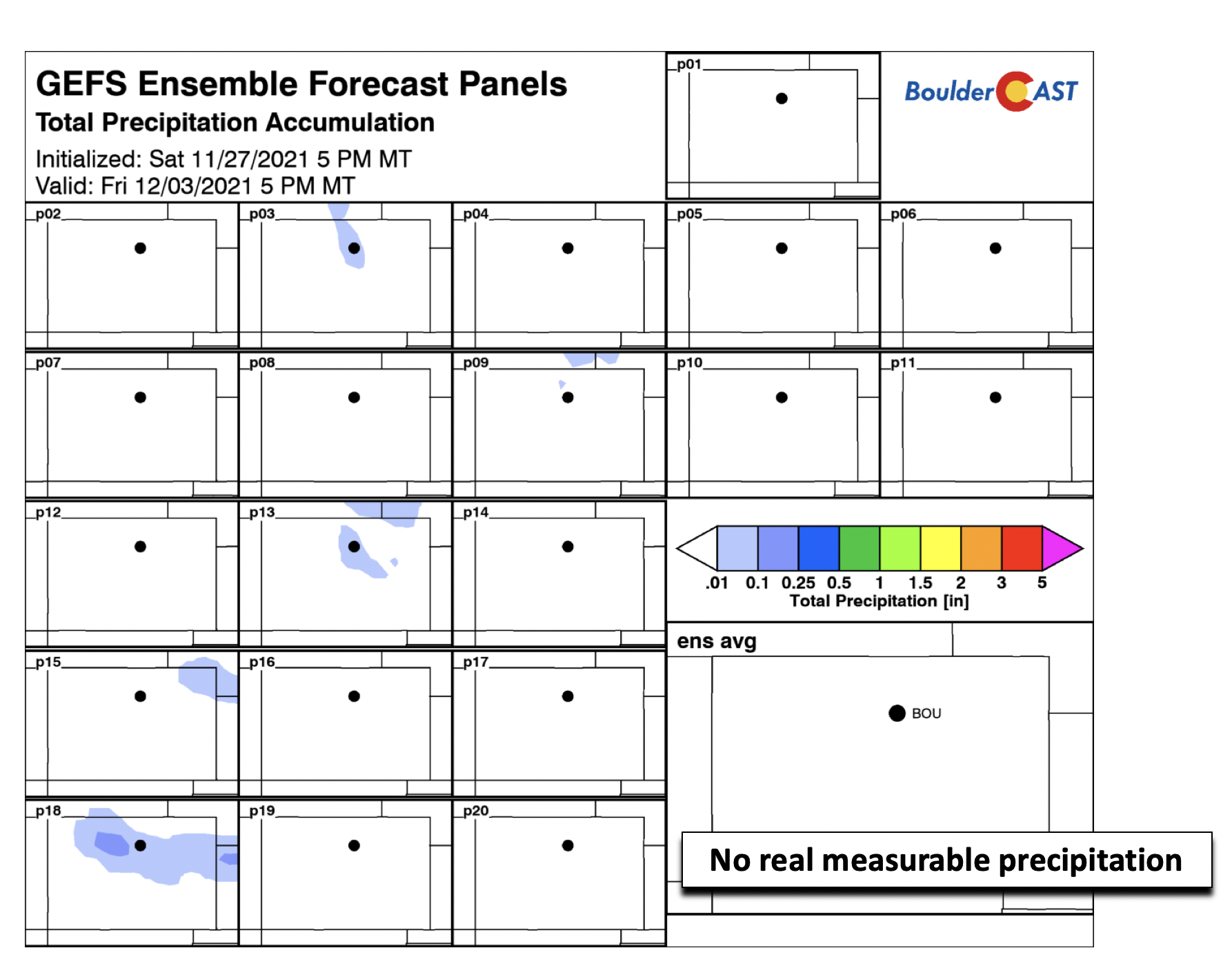
Looking at our in-house GEFS maps of total precipitation, you can see that indeed a few members show some accumulation, but the mean is pretty much squat. As you’ll see, there are no systems really of note for the week to warrant any precipitation chances for the Front Range.
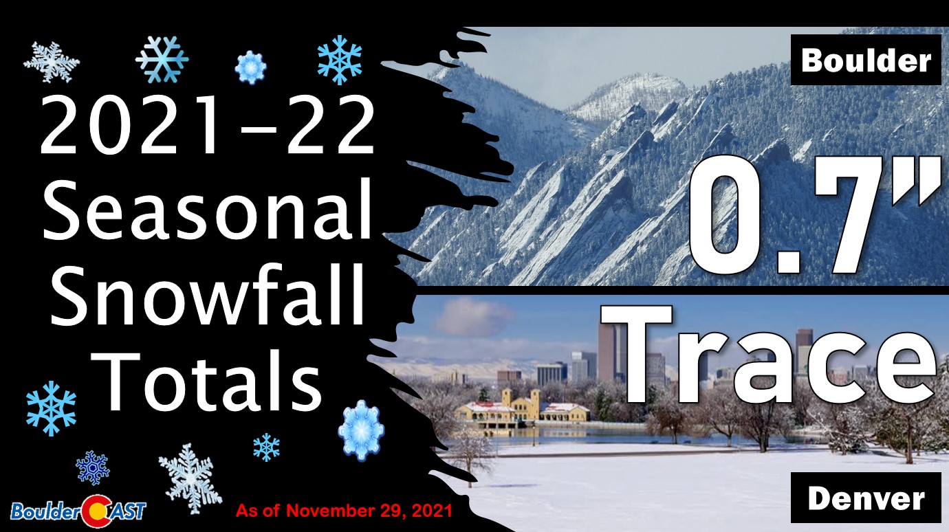
Our snowfall deficit will thus continue for this week. Boulder has now reported snow on five different occasions, but this has only amounted to a meager total of 0.7″ so far. Denver has yet to see any measurable snow this season and continues to extend the new record with each passing day.
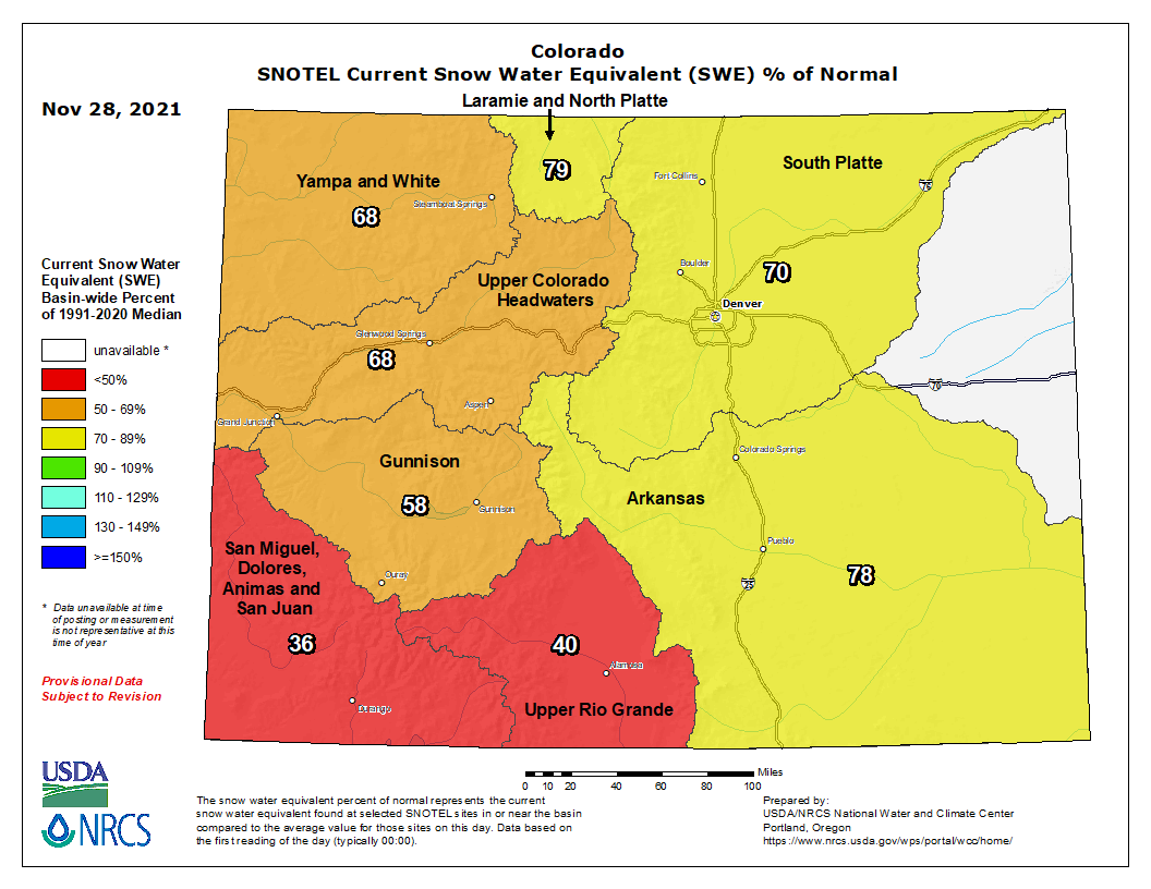
The story in the Mountains has become similar to the lowlands of late. The current SNOTEL snow water equivalent map below shows that the entire state currently has below average snowpack, most strikingly over the west and southwest parts of the state which are at 35 to 55% of normal.
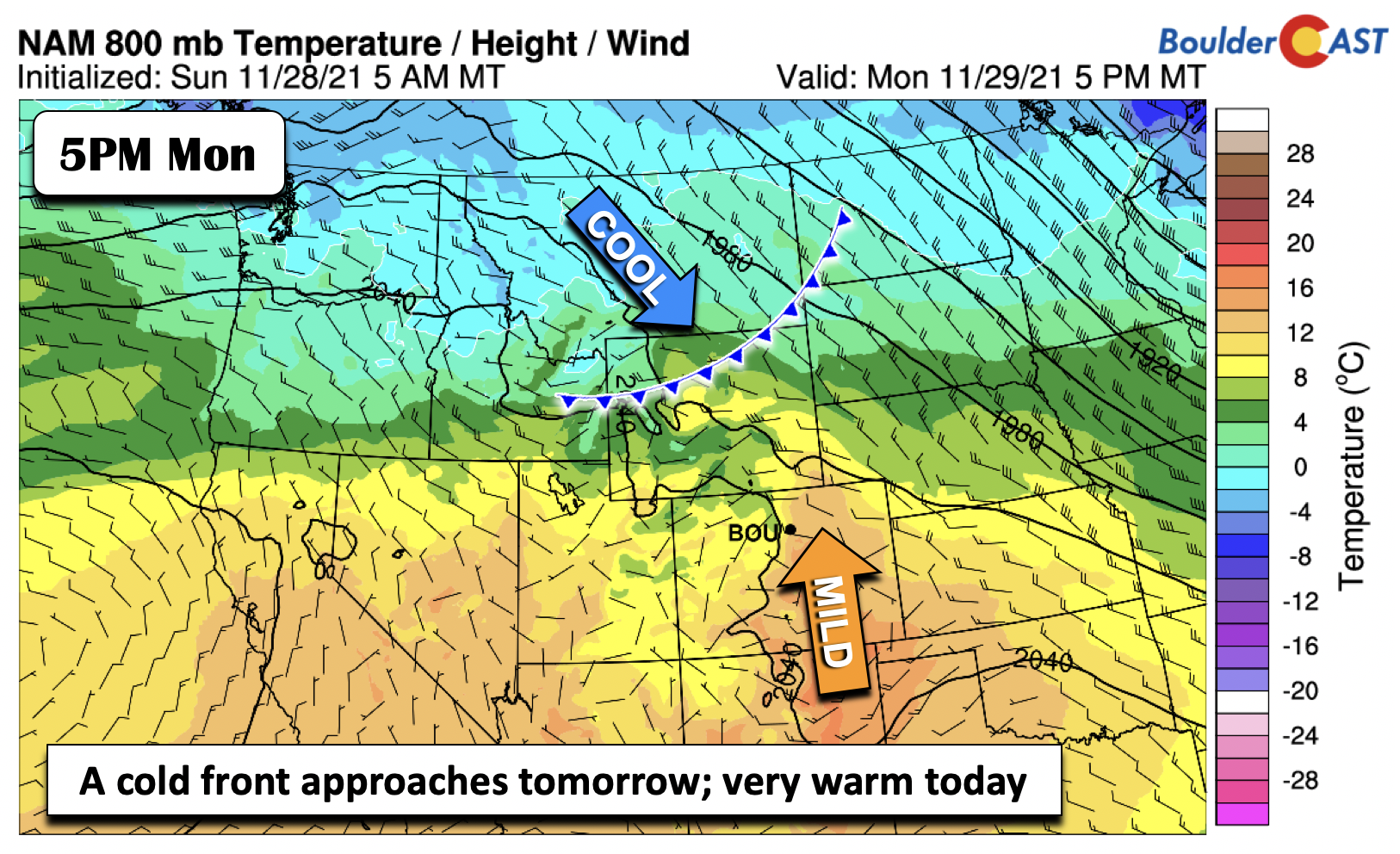
Today, we continue where we left off on Sunday, with that ridge/trough pattern over the nation. Troughing persists over the eastern United States, with ridging out west. Embedded in the northwest flow to our east are several shortwaves. The next weather system to affect us is currently out over Washington state, set to bring a weak cold front through Boulder by Tuesday morning.

Before that front arrives tomorrow, it’s another very mild day across the Plains, with highs rising into the lower 70s. Expect a mix of clouds and sunshine. The majority of the week will be above average, even behind the front tomorrow.
Just a brief “cool-down” Tuesday
On Tuesday, the cool front slides south, barely reaching the northern tip of New Mexico. The surge is not particularly strong, but the airmass cools from roughly 14°C to around 5°C at the low-levels. Highs will likely drop to the upper 50s to lower 60s on Tuesday as a result. This, however, is still above our average highs for this time of year (which are in the upper 40s).

The brief reprieve from very warm temperatures is short-lived. The ridge builds back in, this time stronger, with well-above average temperature anomalies stretching across the majority of the West. Highs on Wednesday should get back close to 70 degrees. On Thursday, likely to be our warmest day of the week, we could see low to perhaps middle 70s.

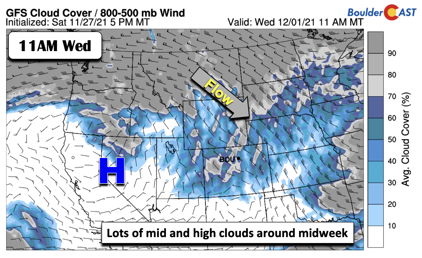
Although the ridge will be in place by midweek, northwest flow aloft will not be far from us, located just upstream over Montana. High anomalous upper-level moisture will spread patches of mid and high clouds from time to time across the area by the middle to late parts of the week. This should make for gorgeous sunsets so keep those cameras handy.
More active pattern next week?
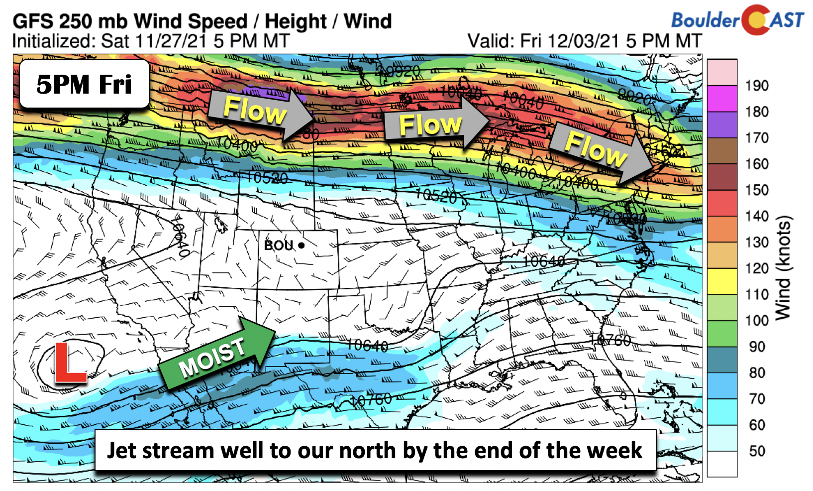
By Friday, the upper-level polar jet stream hugs the U.S./Canadian border, stretching roughly west to east from the Pacific Northwest into the Great Lakes and New England. The subtropical jet stream will start to become a little more active, with a cut-off system developing near the Baja. Colorado will be sandwiched in-between these two jet streams. The models are hinting of a secondary small cool-down to end the work week, with highs potentially dropping to the lower 60s or the 50s on Friday. It is unclear if this is related to a weak front or not, but nevertheless expect a slow downward trend (still above seasonal norms) toward the end of the week.
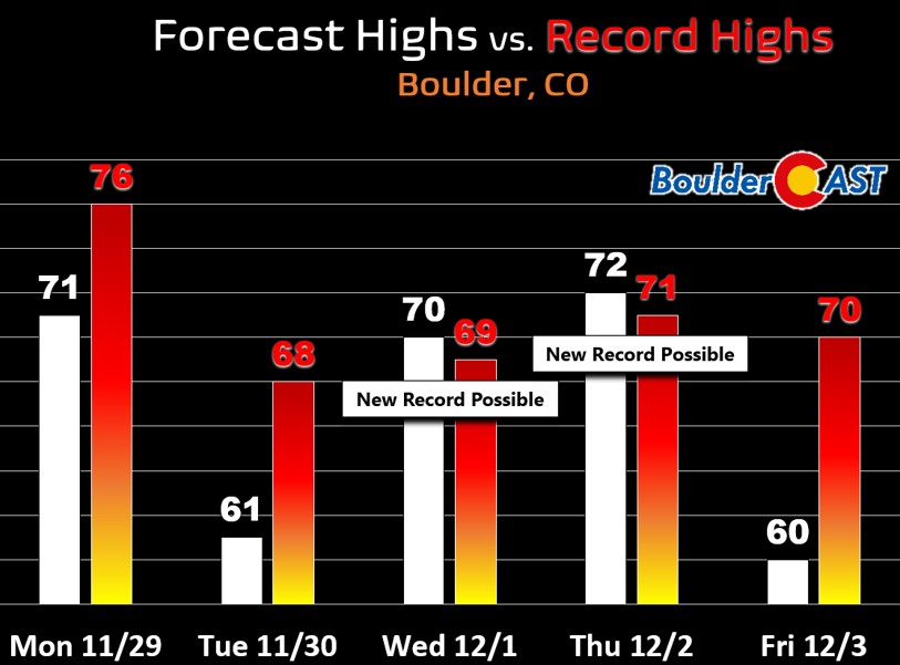
Wednesday and Thursday have the potential to set new daily record high temperatures across the area. The graphic below shows our forecast highs (white) compared to Boulder’s existing record values (red).
While the upcoming weekend and early next week is quite a ways off, there are some indications, particularly from the ECMWF/GFS/GEFS models that a more active pattern may start to evolve by the middle of next week. The two deterministic solutions below show a potential switch away from the ridge/trough pattern that has been in place for the better part of two weeks now. These solutions show a developing trough over Colorado by next Wednesday (December 8th).
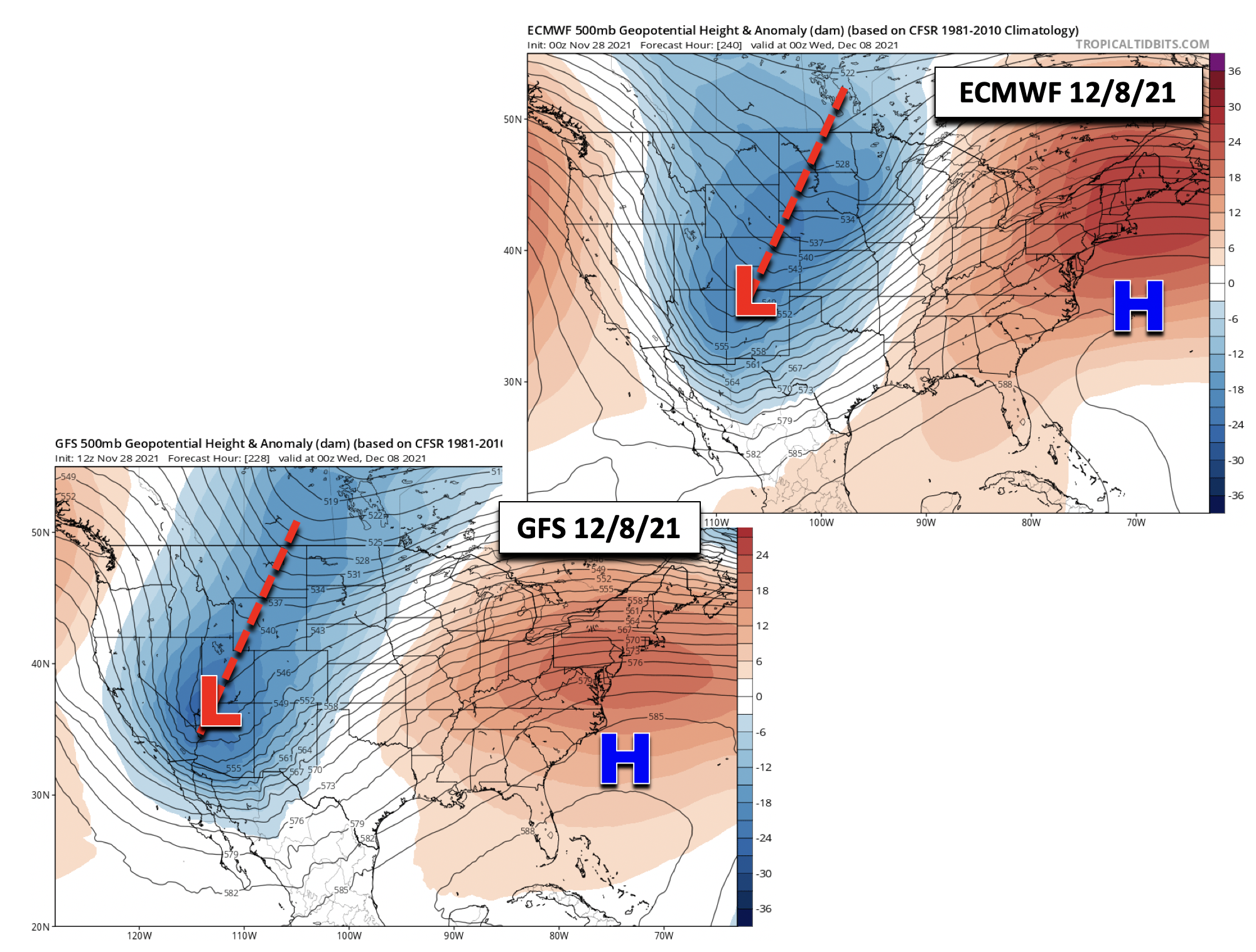
We are not at all confident about this shift but it may be a good sign for our snow drought and is something worth keeping an eye on in the extended. Despite what we are seeing in some models, on the contrary the Climate Prediction Center is forecasting a good chance of continued warm and dry weather next week for much of Colorado, so that’s not great.
Have a good week and enjoy the continued extremely unseasonable warmth.
Stay up to date with Colorado weather and get notified of our latest forecasts and storm updates:
We respect your privacy. You can unsubscribe at any time.
Forecast Specifics:
Monday: Mostly sunny and warm with highs in the lower 70s on the Plains and low 60s in the Foothills.
Tuesday: Partly to mostly sunny and cooler with highs near 60 on the Plains and upper 40s in the Foothills.
Wednesday: Lots of sun with highs back into the upper 60s to near 70 on the Plains and upper 50s in the Foothills.
Thursday: Mostly sunny and very mild with highs in the low to middle 70s on the Plains and low 60s in the Foothills.
Friday: Increasing clouds and cooler with highs in the low 60s on the Plains and low 50s in the Foothills.
Mountains: Warm and dry conditions will be in place through the entire week across the High Country with zero chances for accumulating snow. Gusty west-northwest winds will be likely Monday and Tuesday, between 30 and 50 MPH at times along mountain passes and high-summit peaks.

Snowfall totals expected through Saturday. Yikes!
Help support our team of Front Range weather bloggers by joining BoulderCAST Premium. We talk Boulder and Denver weather every single day. Sign up now to get access to our daily forecast discussions each morning, complete six-day skiing and hiking forecasts powered by machine learning, first-class access to all our Colorado-centric high-resolution weather graphics, bonus storm updates and much more! Or not, we just appreciate your readership!
.
Spread the word, share the BoulderCAST forecast!
.


You must be logged in to post a comment.