
November will commence with very warm and dry conditions across the Front Range as high pressure dominates our weather for yet another week. Afternoon temperatures each day will approach (but likely not exceed) record values. Changes begin to take shape Friday into the upcoming weekend as a strong and cold storm system drops out of western Canada. Initially this will lead to strong winds and high fire danger for Colorado, but snow may be in the works as well.
This week’s highlights include:
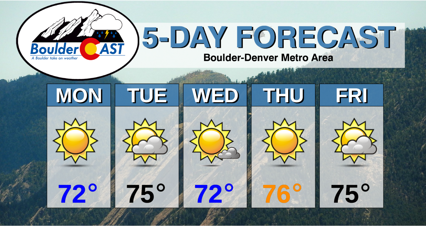
- Unseasonably warm temperatures all week long under high pressure
- Highs in the 70’s each day, nearing record values
- No chance of precipitation, only a few clouds
- A strong and cold storm system approaches this weekend leading to windy conditions and high fire danger, heavy snow in the San Juans
- The weekend system will be slow to move in, but could eventually produce snow for us
DISCLAIMER: This weekly outlook forecast is created Monday morning and covers the entire upcoming week. Accuracy will decrease as the week progresses as this post is NOT updated. To receive daily updated forecasts from our team, subscribe to BoulderCAST Premium.

Unseasonable warmth all week long
Monday morning’s infrared satellite animation from GOES-East is shown below. All of the large-scale weather features are on-display across North America in this animation. We have a deep trough digging into the Great Lakes and Northeast United States. Hurricane Eta in the western Caribbean is going to make landfall in Nicaragua later today. Across the West, a dominant ridge is in control with the jet stream pushed well to the north into Alaska and western Canada. As a result, nearly the entire western two-thirds of the United States are cloud-free this morning. The only exception lies in the vicinity of a weak cut-off low pressure system currently situated off the coast of southern California. Notice the slight rotation in that area and a few clouds developing.

GOES-East infrared satellite animation from Monday morning
If we alternatively gander at the GFS 500mb forecast map for this morning (below), we see all of these same features here as well spread across the United States. This is why we love to show 500mb maps generously in our forecast discussions. They highlight the large-scale, key weather features rather well, making it easy to see the focus for any given day, or in this case, the week ahead.
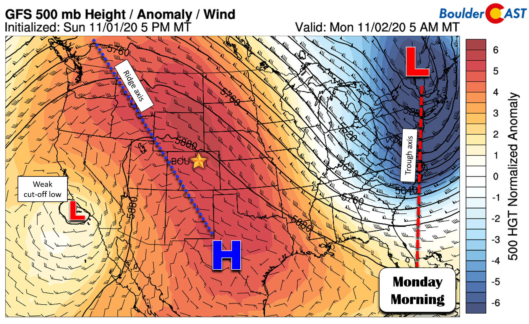
The main weather players for Colorado this week will be that strong ridge which will flatten but remain intact across our area throughout the week. We’ll also have to deal with the cut-off low near California which will eventually slip eastward and progress directly across Colorado late Tuesday into Wednesday. This system will bring only a few clouds to the area on Tuesday, and then slightly cooler temperatures on Wednesday. Otherwise, the overall story this week will be the lengthy period of unseasonably warm temperatures in the 70’s across the Front Range combined with mostly clear skies. There are essentially zero percent chances for any precipitation throughout the week. The forecast animation below shows the evolution at 500mb through Friday evening. You should be able to see everything we just discussed.

GFS 500mb height anomaly forecast animation through Friday evening
However, one thing we didn’t mention yet is that models are forecasting a strong and bitter cold storm system to dive southward during the upcoming weekend into the Great Basin. Note this development at the end of the animation above. There is considerable model and ensemble support for this feature’s strength, track and timing right now, so we have high confidence that it will show up this weekend. The pattern indicated for Friday into Sunday across the country has a potent ridge over the East Coast and that strong trough in the Great Basin (see below). This setup likely will result in a very intense pressure gradient across Colorado for an extended period. This is shown in the pink boxed areas below.

As a result of this gradient, there will be an embedded swath of strong southwesterly winds on the eastern flank of the trough. This swath will be slow-moving and progress across Colorado Friday into Sunday leading to a period of blustery conditions across the higher terrain and most likely across the lower elevations as well. The wind forecasts at ~10,000 feet elevation for Friday and Saturday are shown below. After another five days of dry, sunny and very warm conditions, these winds will bring fire weather conditions to the forefront again across our state. At this point, four days out, it appears the focus for the strongest winds will be across the Mountains of central and western Colorado on Friday. Saturday the core of the winds may shift eastward to encompass central and eastern Colorado. This may persist into Sunday as well, though things should be starting to quiet down late in the weekend in terms of winds. We’ll probably see a few days with Red Flag Warnings during this time.

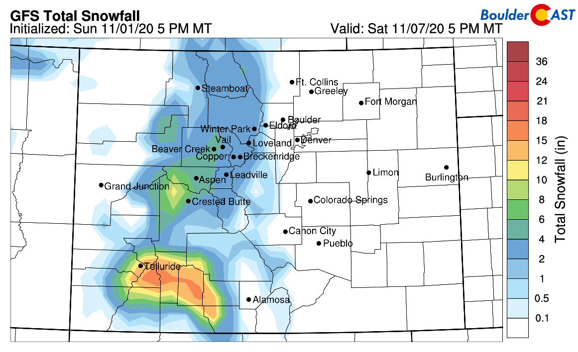
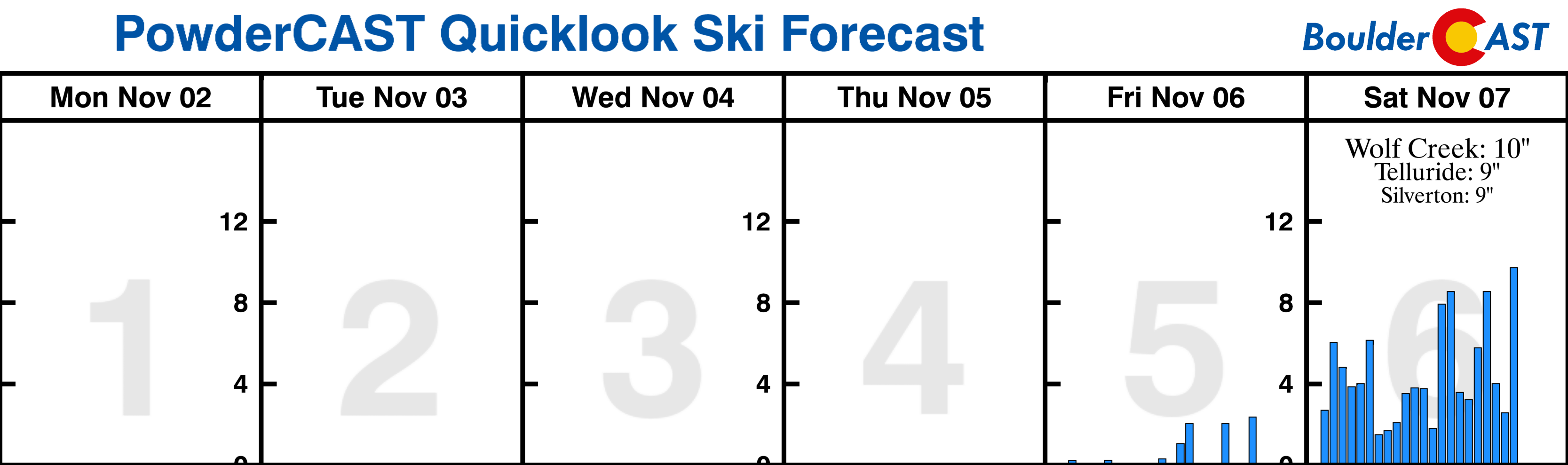
These southwesterly winds Friday night into Saturday will also favor orographic snow in the San Juans of southwestern Colorado. Upwards of a foot could pile up in areas from Telluride to Wolf Creek. Elsewhere across the central and northern Mountains, lesser amounts will be possible.

Exactly what happens with this trough afterwards remains a point of disagreement in the models right now. The initial push of energy with this trough may never fully make it into eastern Colorado with a dry downslope set-up accompanying a cold front on Saturday (maybe a few spotty rain showers?). However, a reinforcing trough of low pressure may develop late in the weekend and bring wintry weather to our area on Monday. Unfortunately, this is too far out to make any specific predictions, but at the very least a much colder and more unsettled pattern should take hold by late in the weekend into early next week.

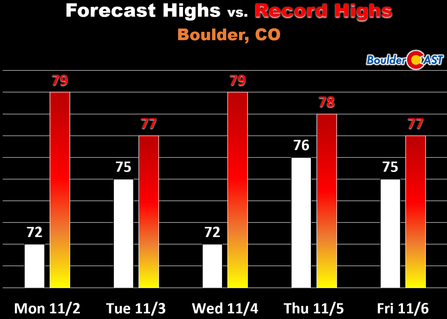
For now… enjoy what could be our last extended period of 70+ degree weather. Boulder will challenge but probably not set any new record highs this week. So…winning?
Forecast Specifics:
Monday: Sunny and warm. High temperatures in the lower 70’s on the Plains and upper 50’s in the Foothills.
Tuesday: Partly cloudy and warm. Highs in the mid 70’s for the Plains and lower 60’s in the Foothills.
Wednesday: Mostly sunny and slightly cooler. Highs in the lower 70’s for the Plains and upper 50’s in the Foothills.
Thursday: Sunny and very warm with highs in the middle 70’s on the Plains and lower 60’s for the Foothills.
Friday: Warm and possibly gusty with increasing clouds. Highs in the middle 70’s for the Plains and lower 60’s in the Foothills.
High Country: Unseasonably warm temperatures and dry conditions will also be present in the Mountains this week. As the trough approaches, southwesterly winds will become very strong and produce dangerous fire conditions statewide Friday into Saturday. These winds will also favor snowfall in the San Juans late Friday through Saturday. A few inches of snow will be possible across the entire Mountains on Saturday. Find forecasts for all the Colorado ski resorts over at our PowderCAST page. Here’s a look at the snowfall outlook for the next six days.
Help support our team of Front Range weather bloggers by joining BoulderCAST Premium. We talk Boulder and Denver weather every single day. Sign up now to get access to our daily forecast discussions each morning, complete six-day skiing and hiking forecasts powered by machine learning, first-class access to all our Colorado-centric high-resolution weather graphics, bonus storm updates and much more! Or not, we just appreciate your readership!
.
Spread the word, share the BoulderCAST forecast!
.


You must be logged in to post a comment.