
The story since late last week has been the infiltration of smoke into the Front Range from distant but numerous Canadian wildfires. That trend will unfortunately continue early in the week with light to moderate smoke sticking around through at least Tuesday or Wednesday leading to degraded air quality. Fortunately, the pattern will shift midweek whisking away the smoke and changing the headlines to rain and thunderstorms for a few days. Let’s take a look at what is sure to be another interesting week in Colorado weather!
This week’s highlights include:
- Another surge of smoke came into the area late Sunday night — Monday will be smoky with AQIs from 100 to 130 (Unhealthy for Sensitive Groups)
- Smoke will linger but improve in the coming days as winds shift taking most of the smoke back northward into Canada
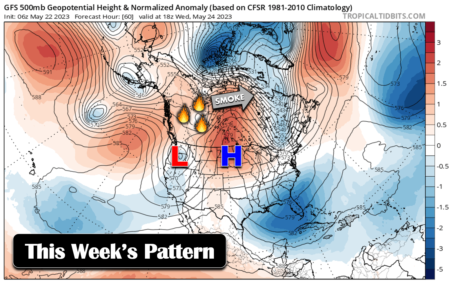
- A ridge develops across the center of the country midweek sending a surge of moisture into Colorado from the southwest — storm chances on the rise!
- A good chance of late-day thunderstorms Wednesday through Friday — some risk for severe weather, mainly east of Denver
- Temperatures will generally be in the mid to upper 70s each day this week

DISCLAIMER: This weekly outlook forecast is created Monday morning and covers the entire upcoming week. Accuracy will decrease as the week progresses as this post is NOT updated. To receive daily updated forecasts from our team, among many other perks, subscribe to BoulderCAST Premium.

Go Premium, get all the perks.
Daily Forecast Updates
Get our daily forecast discussion every morning delivered to your inbox.
All Our Model Data
Access to all our Colorado-centric high-resolution weather model graphics. Seriously — every one!
Ski & Hiking Forecasts
6-day forecasts for all the Colorado ski resorts, plus more than 120 hiking trails, including every 14er.
Smoke Forecasts
Wildfire smoke concentration predictions up to 72 hours into the future.
Exclusive Content
Weekend outlooks every Thursday, bonus storm updates, historical data and much more!
No Advertisements
Enjoy ad-free viewing on the entire site.
Decreasing smoke and increasing storm chances this week
Thick smoke from large Canadian wildfires first reached the Front Range this past Thursday night. After a very bleak day on Friday with Unhealthy (for everyone) air quality, things did improve gradually over the weekend such that some locations got back closer to normal by Sunday afternoon. However, a secondary pulse of smoke from the very same fires in Canada moved in Sunday night causing a slight regression in air quality over the entire region. GOES-East visible satellite imagery on Monday morning shows entirely cloud-free skies over the Front Range, with nothing by thick smoke blanketing the region.
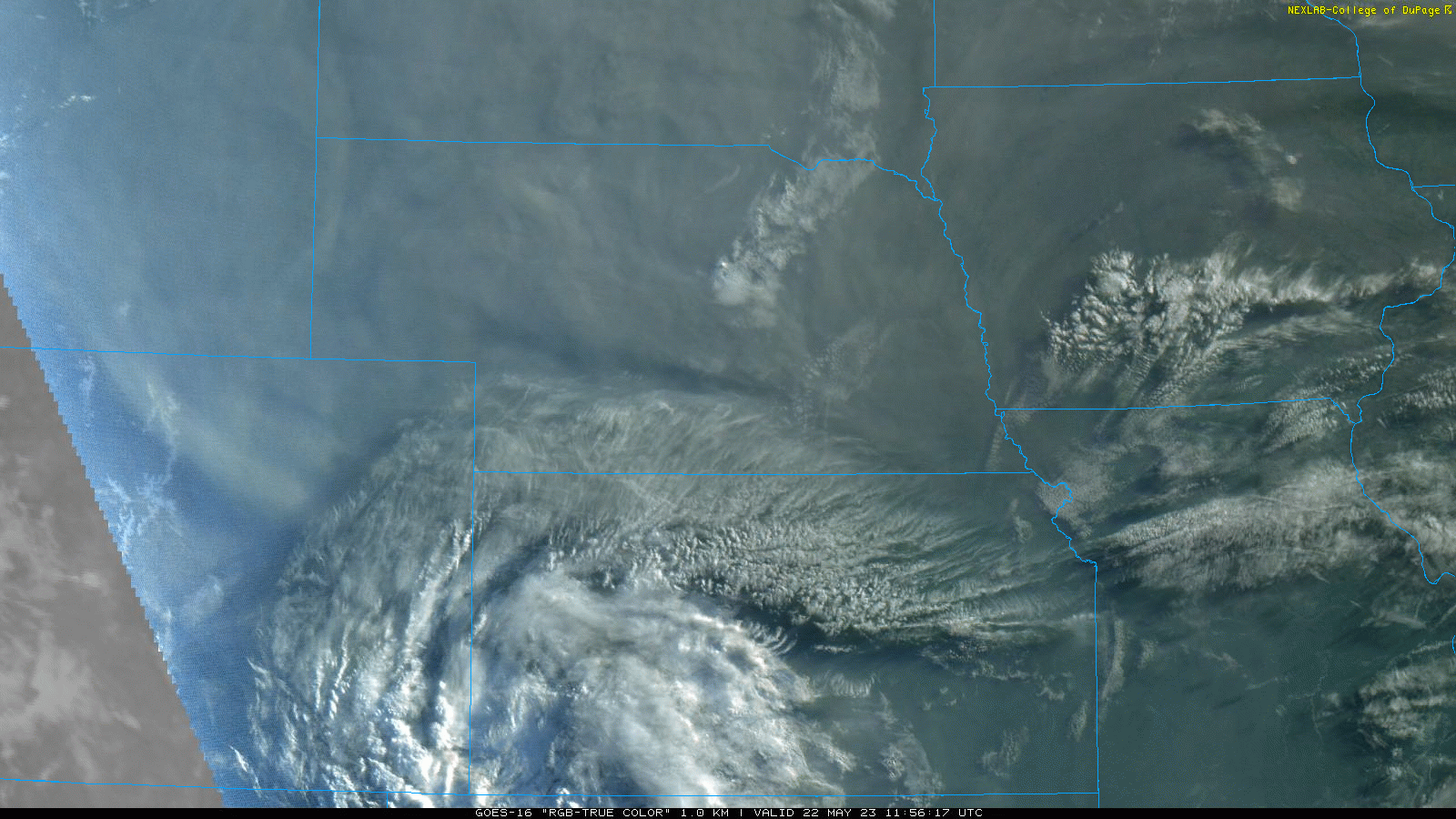
GOES-East visible animation from Monday morning showing extensive smoke in northeast Colorado
As of early Monday morning, PM2.5 Air Quality Indices generally rest between 80 and 110 across our area.
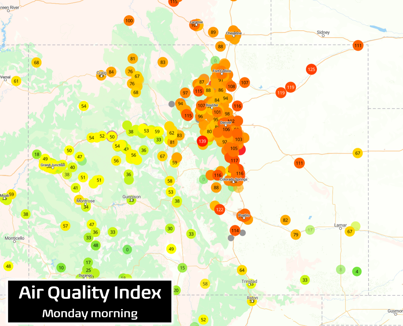
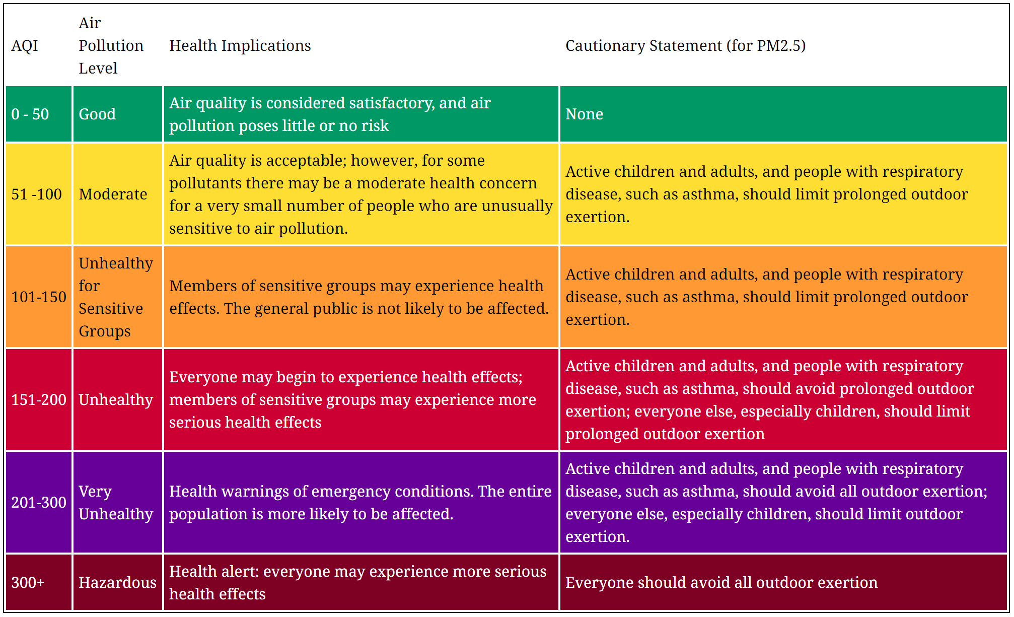
While far from ideal, the smoke right now isn’t nearly as bad as it was on Friday when values ranged from 140 to 180 across our area. As a reminder, the table below shows the implications on health from various levels of air quality. Use this as you will!
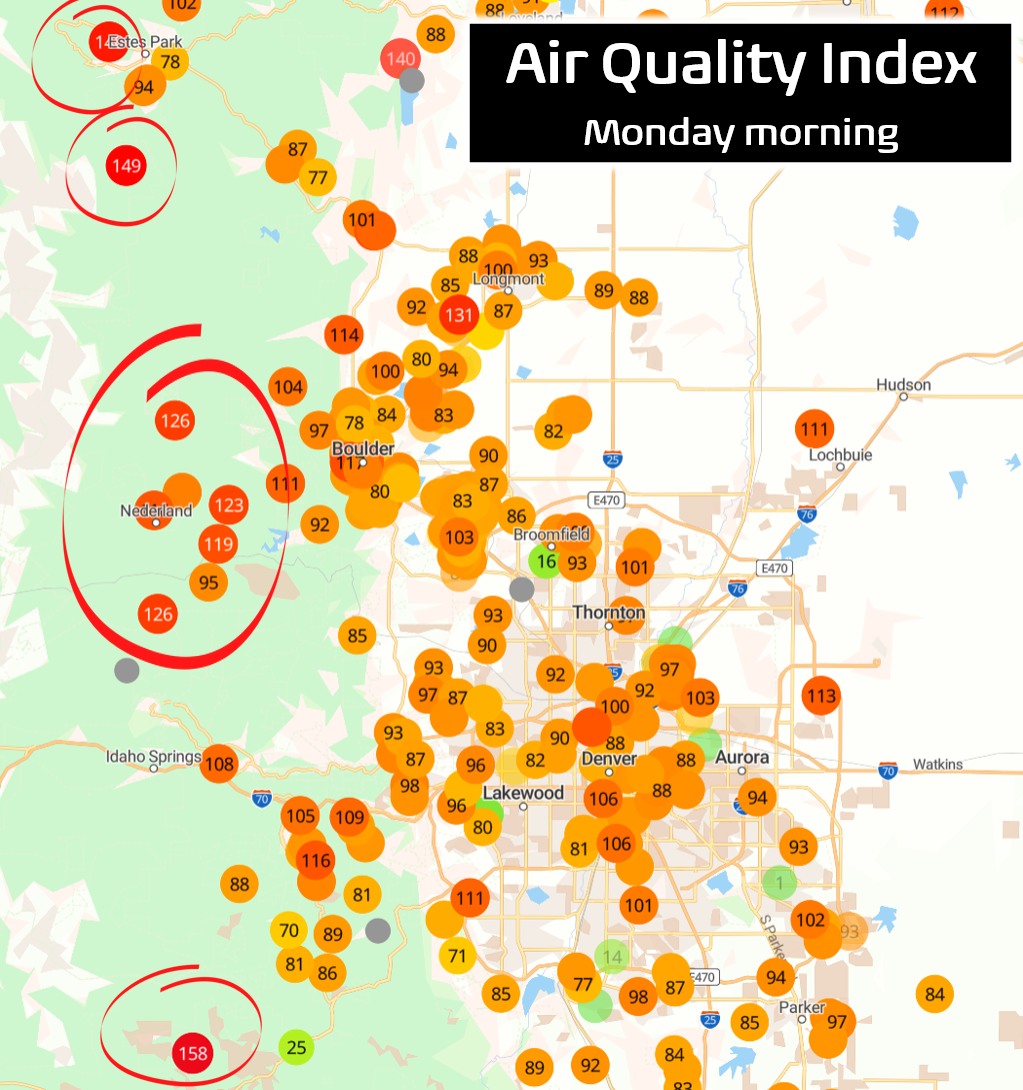
A closer inspection of just the Denver area shows us that the smoke is actually worse this morning in the Foothills, the opposite of the prior surge of smoke late last week. That is, smoke is more highly concentrated higher up in the atmosphere. This tells us that smoke levels are not likely to improve much during the day on Monday. If anything, it will get worse as daytime mixing brings down some of the smoke from higher up.
While the latest ground-level smoke forecast lends to improving conditions across eastern Colorado in the coming days under southeasterly low-level flow, we do expect light to moderate smoke to linger across the Front Range through at least Tuesday, if not a few days longer. Southeasterly flow will tend to pool the smoke in and near the Foothills, particularly from Boulder County northward. Regardless, visibility and air quality will gradually improve through the week for us as the worst of the Canadian wildfire smoke stays along and north of the border with the United States. After Monday, there won’t really be any new smoke entering the picture, but instead the situation here will just be a pooling and redistribution of existing particulates.

Sadly, the dozens of massive fires actively burning in Canada will continue to be an air quality issue for the United States, and at times Colorado, for the next several weeks or even months. These fires are burning in remote locations and the only real firefighter working some of them right now is Mother Nature — and she’s not doing a great job.
The main reason smoke will be on the decrease this week across Colorado is an upcoming broad pattern shift over North America, one which will see a ridge develop over the center of the continent, focused most strongly over the northern Plains into Canada. At the same time, a trough of low pressure will be stalled out over the Pacific Northwest, teaming up with the ridge to create southwest flow aloft into and across Colorado. This will be the ideal direction to keep smoke at bay, but in the process it will slowly increase moisture into the region through the week leading to an uptick in storm chances.
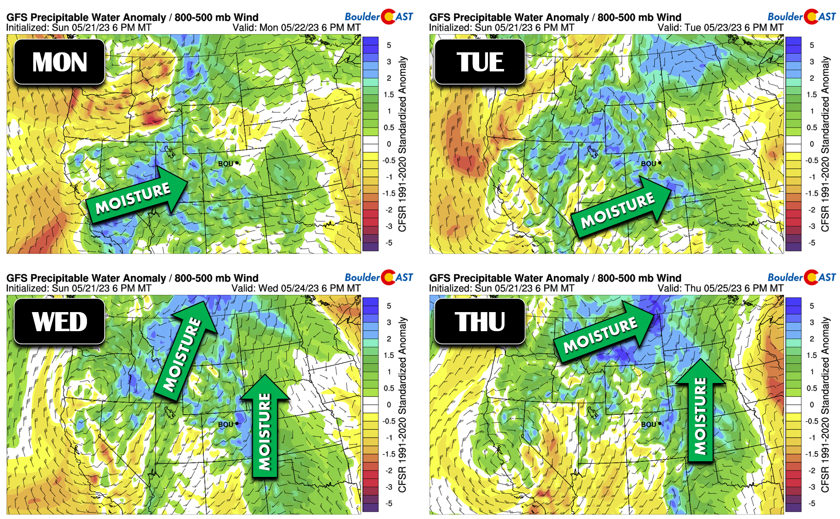
The four-panel forecast graphic below shows atmospheric moisture anomalies from the GFS model each day through Thursday. While moisture begins the week near normal in the Denver area, by Wednesday and Thursday we will surge to 2 or 3 standard anomalies above normal which will certainly fuel a sizable increase in diurnal storms for us.
The GFS ensembles below show this progressive uptick in storms nicely throughout the week. While things will be fairly spotty Monday and Tuesday, storms will become numerous Wednesday and beyond as the best moisture arrives from the southwest (aloft) and southeast (at the surface).

For Monday, look for storms to develop in numbers across the higher terrain only, while the lower elevations remain quite stable under smoky skies. Expect just a slight chance of a shower or storm coming off the Foothills into Boulder late on Monday — a 5% outing or less. There’s basically no chance of rain east of Interstate 25 on Monday. Do plan for wet weather if heading up into the Mountains. Tuesday will be overall similar, but with slightly better chances for storms everywhere as moisture creeps up and smoke dissipates further allowing for more instability to develop in the Boulder-Denver area especially. Still, we’re looking at just a 10% chance of rain on Tuesday.

HRRR model-simulated radar animation for Monday across the Front Range. Storms develop and stay over the higher terrain.
Both Monday and Tuesday will see above normal temperature in the upper 70s. For reference, our average highs this time of year should be in the middle 70s or so.

Wednesday is when moisture really begins to surge and it’ll stick around through Friday based on current guidance. This will lead to a rinse-and-repeat stormy forecast for the mid- to late-week period with daily chances for storms during the afternoon and evening — and decent ones at that (40 to 60%). High temperatures will stay seasonal in the middle to upper 70s, restricted mainly by the amount of clouds/storms that will develop each afternoon.
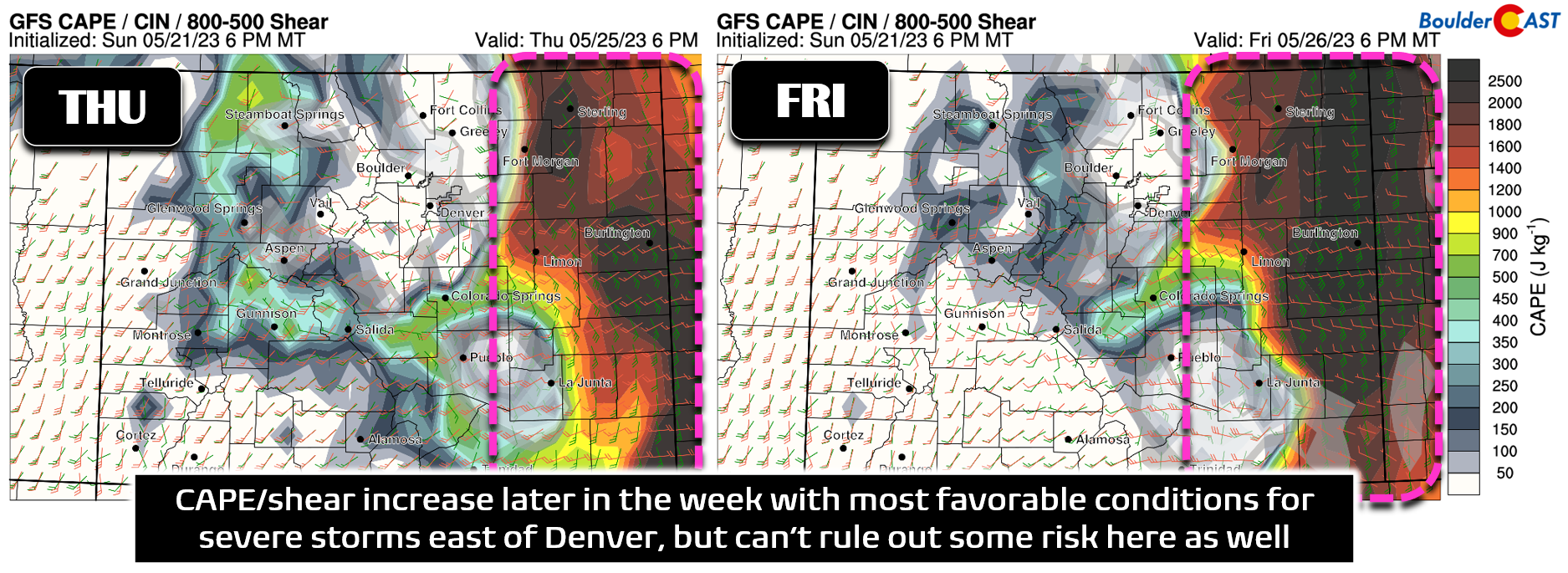
As far as severe weather goes, the threat will increase for Colorado Wednesday and thereafter. It’s too early to pinpoint specifics, but moderately strong southwest flow aloft is typically a good setup for severe storms here on the Plains. Right now it looks like the risk will be highest Thursday and Friday east of Denver towards Kansas and Nebraska, though we can’t rule out the risk in our neck of the woods entirely either day. Large hail would be the main concern.
Overall, this should be a decent week for us with decreasing smoke while late-spring thundershowers are on the increase. Enjoy the weather!

View from a hike somewhat above the smoke on Saturday, though storms were building
Forecast Specifics:
Monday: Smoky skies during the day with PM2.5 Air Quality of 90 to 120. Morning sun gives way to afternoon clouds with scattered storms in the Foothills. The lower elevations remain dry. Highs in the middle 70s across the Plains with lower 60s in the Foothills.
Tuesday: Lingering smoke, but improving. Sunny early, then a few clouds and isolated thunderstorms develop during the late-day. High temperatures in the upper 70s across the Plains with middle 60s in the Foothills.
Wednesday: Partly to mostly cloudy with numerous thunderstorms developing during the afternoon and evening. Some light smoke may linger. A few storms could be strong and produce heavy rainfall. A tad cooler due to the clouds/rain. Highs reach the middle 70s on the Plains with lower 60s in the Foothills.
Thursday: Morning sun, then scattered to numerous late-day thunderstorms capable of producing heavy rainfall. Some storms could turn severe especially east of Denver. Highs in the middle to upper 70s on the Plains with middle 60s in the Foothills.
Friday: Morning sun, then scattered to numerous late-day thunderstorms capable of producing heavy rainfall. Some storms could turn severe especially east of Denver. Highs in the middle to upper 70s on the Plains with middle 60s in the Foothills.
DISCLAIMER: This weekly outlook forecast is created Monday morning and covers the entire upcoming week. Accuracy will decrease as the week progresses as this post is NOT updated. To receive daily updated forecasts from our team, among many other perks, subscribe to BoulderCAST Premium.
Go Premium, get all the perks.
Daily Forecast Updates
Get our daily forecast discussion every morning delivered to your inbox.
All Our Model Data
Access to all our Colorado-centric high-resolution weather model graphics. Seriously — every one!
Ski & Hiking Forecasts
6-day forecasts for all the Colorado ski resorts, plus more than 120 hiking trails, including every 14er.
Smoke Forecasts
Wildfire smoke concentration predictions up to 72 hours into the future.
Exclusive Content
Weekend outlooks every Thursday, bonus storm updates, historical data and much more!
No Advertisements
Enjoy ad-free viewing on the entire site.
Get BoulderCAST updates delivered to your inbox:
Enjoy our content? Give it a share!


You must be logged in to post a comment.