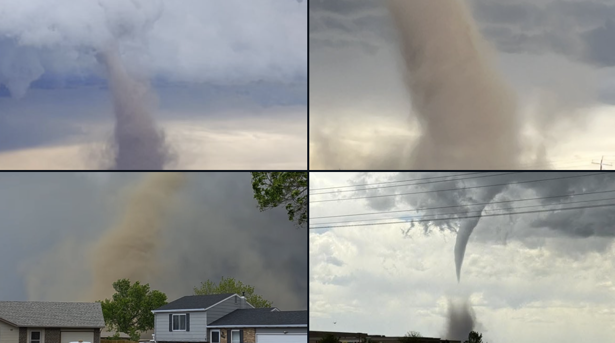
Sunday’s storms brought a slew of severe weather to northeast Colorado, including a photogenic tornado east of Denver. This week will be relatively quiet, but there is still plenty to discuss. Monday will stay cool and showery, but drier and warmer weather is on-tap for the rest of the week. However, a weekend trough will threaten to shake things up again—could the Memorial Day Weekend forecast include stormy skies? Read on for all the details.
This week’s highlights include:
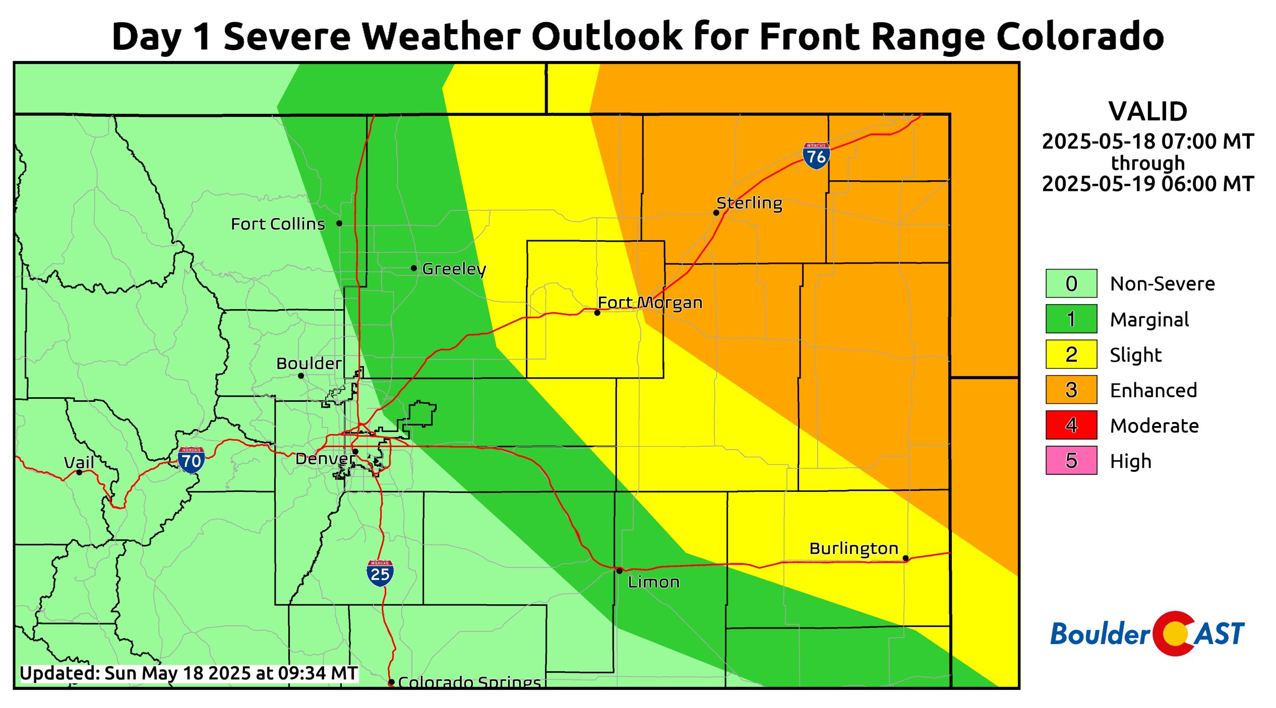
- Sunday’s severe weather brought a mix of storms, including a strong thunderstorm in Boulder and a tornado east of Denver. While there were no injuries, the tornado damaged buildings and destroyed a solar farm.
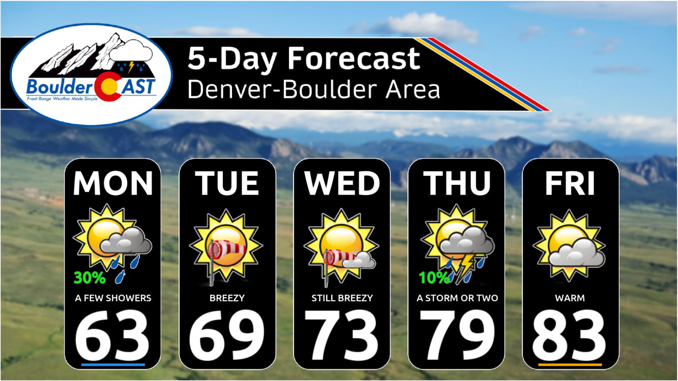
- Monday’s weather will be cloudy with scattered showers, mostly south of the Palmer Divide, but Boulder and Denver could see light rain and a few storms. Highs will be in the lower 60s.
- A warming trend begins Tuesday as Colorado shifts into drier conditions with gusty northwest winds. Temperatures will reach near 70°F Tuesday and mid-70s Wednesday before pushing into the 80s later in the week.
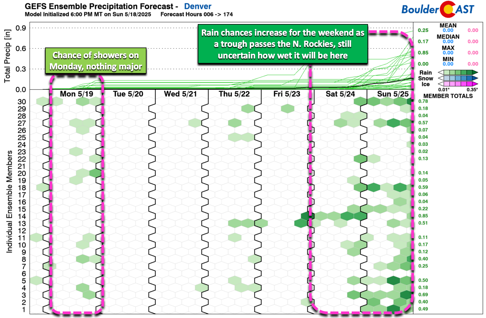
- Holiday weekend uncertainty: A new trough arriving Saturday may bring showers and storms to Colorado, but the exact outcome remains uncertain. It does look like there will be cooler weather and chance for some rain over the weekend.
DISCLAIMER: This weekly outlook forecast is created Monday morning and covers the entire upcoming week. Accuracy will decrease as the week progresses as this post is NOT updated. To receive daily updated forecasts from our team, among many other perks, subscribe to BoulderCAST Premium.

Go Premium, get all the perks.
Daily Forecast Updates
Get our daily forecast discussion every morning delivered to your inbox.
All Our Model Data
Access to all our Colorado-centric high-resolution weather model graphics. Seriously — every one!
Ski & Hiking Forecasts
6-day forecasts for all the Colorado ski resorts, plus more than 120 hiking trails, including every 14er.
Smoke Forecasts
Wildfire smoke concentration predictions up to 72 hours into the future.
Exclusive Content
Weekend outlooks every Thursday, bonus storm updates, historical data and much more!
No Advertisements
Enjoy ad-free viewing on the entire site.
Sunday’s severe storms
Northeast Colorado saw a mix of severe weather on Sunday, just as expected. The strongest thunderstorm to hit Boulder in the afternoon brought a few 1-inch hailstones to the south side of town—this ended up being the westernmost storm to reach severe criteria on Sunday. Most of the hailstones were smaller than 1″, causing little damage aside from shredding early garden plants.
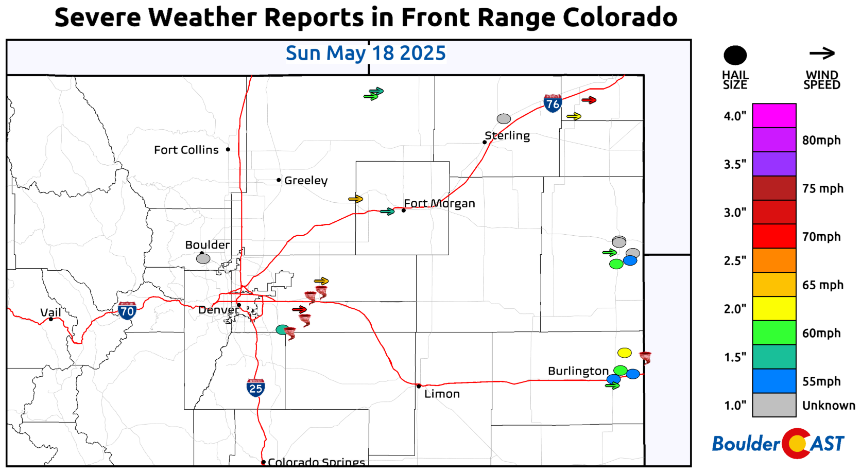
The standout event of the day was the picturesque tornado east of Denver, which captured attention both for its dramatic appearance and the unfortunate destruction it left behind. While no injuries were reported, the tornado damaged several structures and wiped out a solar farm.
Interestingly, both the Boulder thunderstorm and the tornado-producing supercell formed outside the risk area outlined by the Storm Prediction Center. The complex Denver Cyclone setup sparked storms in unexpected locations, surprising even our team with how far south and west they developed.
In tandem with the severe weather, several inches of snow fell in the Mountains over the weekend. We caught the beginning of the wintry weather Saturday afternoon in Rocky Mountain National Park. The temperature dropped from the 50s to the lower 30s in the blink of an eye as snow rolled in over the Continental Divide!
A quieter week ahead
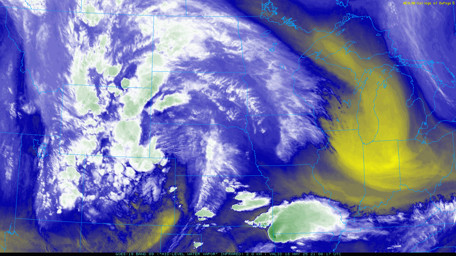
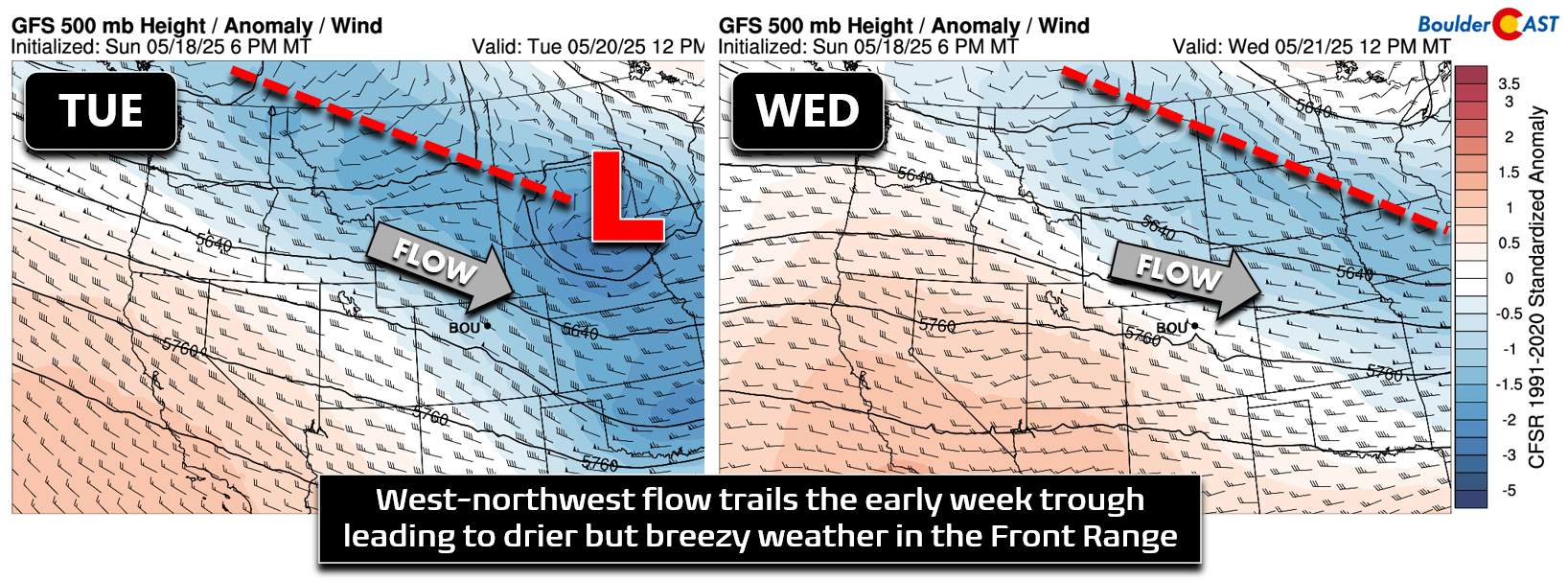
While this week won’t be as active as recent ones, the weather will remain dynamic. Forecast models show a persistent storm track across the northern Rockies, with Colorado beginning the week under a trough that will keep conditions unsettled through Monday. By midweek, the trough moves east, bringing gusty northwest winds for a couple of days. By Thursday and Friday, a weak ridge settles in, pushing temperatures above seasonal norms.
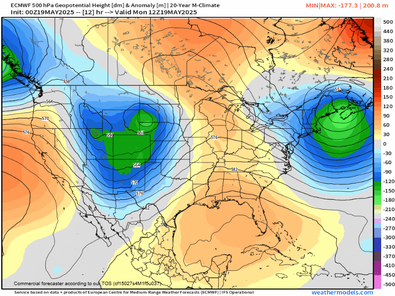
On Monday morning, water vapor satellite imagery shows a classic comma-shaped mid-level low pressure system to our north. While downslope flow has begun here, lingering moisture/lift from the trough will keep clouds and scattered showers in the forecast for our Monday.
Most rain activity Monday will focus south of the Palmer Divide, near a stalled cold front, but Boulder and Denver could still see a few showers or thunderstorms—nothing severe.
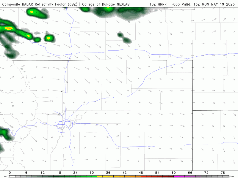
Expect highs in the lower 60s with partly to mostly cloudy skies and a 20–30% chance of showers throughout the day.
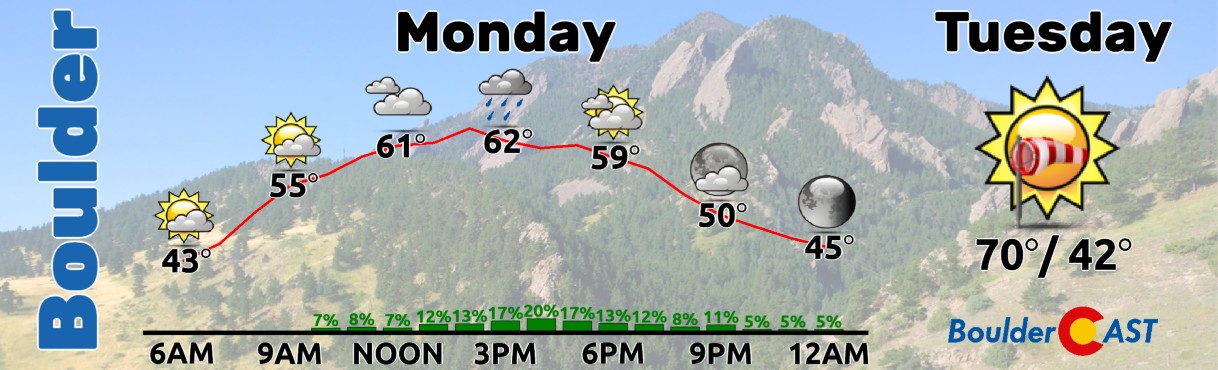
By midweek, Colorado shifts into a drier pattern under brisk northwest flow, bringing warmer temperatures but also more gusty winds. Tuesday’s highs will reach near 70°F, warming into the mid-70s on Wednesday, both days featuring northwest winds of 15–25 MPH.
Later in the week, a small ridge moves across the Southwest, becoming Colorado’s dominant weather feature as the storm track remains focused near the Canadian border.
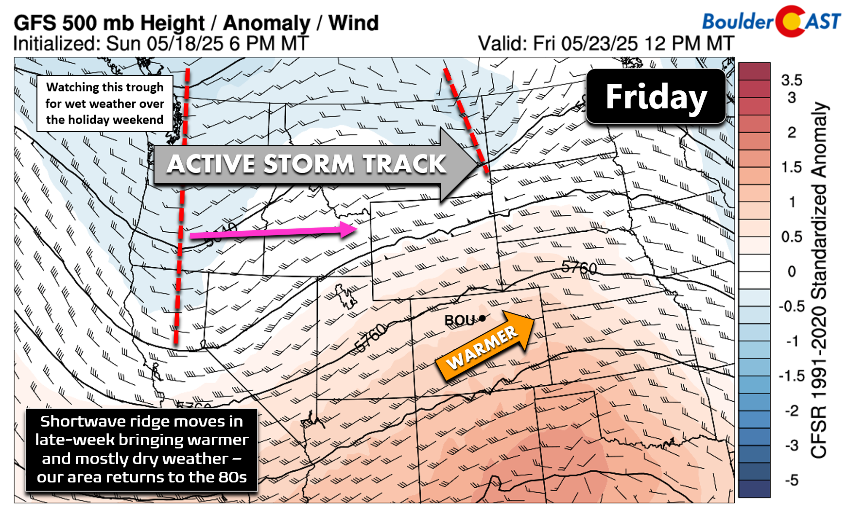
Thursday and Friday will warm up, reaching the upper 70s to mid-80s across the Front Range, with a slight chance of an isolated thunderstorm Thursday. Friday will be partly sunny and warm.
Rain for the holiday weekend?
A new trough will approach from the northwest by Saturday, likely staying north of Colorado. However, forecast models suggest showers and thunderstorms could return sometime during Memorial Day Weekend, depending on exactly how this trough tracks. The best chance appears to be late Saturday into Sunday, but the details are still uncertain. Stay tuned for updates later this week as we get a clearer picture of the weekend forecast.
Forecast Specifics:
Monday: Partly to mostly cloudy with widely scattered rain showers and isolated thunderstorms. Highs reach the lower 60s on the Plains with lower 50s in the Foothills.
Tuesday: Sunny skies but breezy through the day with gusts of 15 to 25 MPH common from the northwest. Temperatures warm a bit towards 70 degrees on the Plains, and into the middle 50s in the Foothills.
Wednesday: Mostly sunny and breezy with gusts of 15 to 25 from the northwest. Highs on the Plains top out in the middle 70s with lower 60s in the Foothills.
Thursday: Morning sunshine followed by a very slight chance of an afternoon thunderstorm. Some storms east of Denver could turn severe. High temperatures warm further towards 80 degrees on the Plains with upper 60s in the Foothills.
Friday: A dry end to the week with highs in the low to middle 80s under partly cloudy skies. The Foothills warm into the lower 70s.
Memorial Day Weekend: A trough will move across the northern Rockies over the weekend bringing unsettled weather. Depending on how this storm tracks, we may get some rain over the weekend, or it could be mostly dry east of the Mountains. For now expect cooler weather with minor chances for rain.
DISCLAIMER: This weekly outlook forecast is created Monday morning and covers the entire upcoming week. Accuracy will decrease as the week progresses as this post is NOT updated. To receive daily updated forecasts from our team, among many other perks, subscribe to BoulderCAST Premium.
Go Premium, get all the perks.
Daily Forecast Updates
Get our daily forecast discussion every morning delivered to your inbox.
All Our Model Data
Access to all our Colorado-centric high-resolution weather model graphics. Seriously — every one!
Ski & Hiking Forecasts
6-day forecasts for all the Colorado ski resorts, plus more than 120 hiking trails, including every 14er.
Smoke Forecasts
Wildfire smoke concentration predictions up to 72 hours into the future.
Exclusive Content
Weekend outlooks every Thursday, bonus storm updates, historical data and much more!
No Advertisements
Enjoy ad-free viewing on the entire site.
Enjoy our content? Give it a share!


You must be logged in to post a comment.