
Another week in May, another series of slow-moving spring storm systems for Colorado! The forecast Monday through Wednesday will be cool and gloomy with daily chances for showers and thunderstorms with even the threat for small hail and locally heavy rainfall. After the one nice day of the week on Thursday, another storm will approach late in the week bringing the chance of rain again alongside somewhat cooler temperatures. Read on for our complete outlook of the unsettled stretch ahead.
This week’s highlights include:
- A pesky spring low in the Four Corners will bring continued clouds and storm chances through Wednesday
- Smail hail and heavy rainfall possible with any storms early in the week due to weak upper-level winds
- Drier and warmer Thursday which should be the nicest day of the week
- Another major trough approaches Friday with unsettled weather looking to return in time for the weekend
DISCLAIMER: This weekly outlook forecast is created Monday morning and covers the entire upcoming week. Accuracy will decrease as the week progresses as this post is NOT updated. To receive daily updated forecasts from our team, subscribe to BoulderCAST Premium.

Persistent gloom continues…
This week begins right where the weekend left off with continued unsettled weather. The high temperature in Boulder on Saturday was in the middle 60’s, but it was even colder on Sunday in the 50’s. While it didn’t rain much overall, the gloom certainly put a damper on the weekend.

Observed high temperatures on Sunday across northeast Colorado
In situations like this, you just know there is a broad weather system somewhere causing all this havoc. Yep! This week’s storm is located in northern Arizona as of Monday morning. This slow-moving cut-off low pressure is already responsible for two gloomy days in the Front Range and there certainly will be a few more in the coming days…

Monday morning’s infrared satellite imagery shows large-scale counter-clockwise rotation across the Desert Southwest. That’s the cut-off low of course! Across eastern Colorado, thick cloud cover is again present so we’re not expecting to see much if any sunshine on Monday as clouds remain locked-in across the area.

GOES-East infrared satellite animation with overlaid 500mb winds/heights from Monday morning
The breadth of the storm and continued slow progression is really helping to pull northward copious amounts of Gulf of Mexico moisture. The Front Range will have the most anomalous moisture levels in the continental United States Monday afternoon (see below). In fact, models are showing precipitable water values around 0.75″ in Denver late Monday, which would be near the record for the date. The extensive moisture will add fuel to the fire, but as we’ve seen the last few days, with thick cloud cover in place it will be difficult to get the widespread convective lift needed to wring out all that record moisture. Similar to what transpired over the weekend, storm coverage will largely be confined to the higher terrain on Monday where some sunshine is more likely but still not guaranteed. This includes the Foothills, Mountains and Palmer Divide. Some of these storms may drift off the higher terrain into the Denver Metro area. This is more likely in the western and southern suburbs.

Once again, the Storm Prediction Center is a glutton for punishment, opting to include the entire Denver Metro area in the Marginal category for severe weather on Monday. If you’ve been paying attention of late, you know we’ve been in this same risk category every day since Friday with nothing to show for it yet. We believe that a few storms could produce small hail on Monday, but as we detailed earlier, the lack of any sunshine will keep the chance of severe hail (greater than 1″), very low to non-existent. Overall, expect a gloomy day on Monday with a good chance of afternoon showers and storms and highs around 60 degrees.

Severe weather outlook forecast for Monday from the SPC
By Tuesday, the cut-off low draws even closer and will move along the Colorado-New Mexico border through the day. This will maximize the upslope flow into the Front Range, turning winds easterly through a large depth of the atmosphere. This will keep skies mostly cloudy and help to alter thunderstorm movement directions. The 500mb winds, as forecast for Tuesday below, will be out of the southeast or east which will keep any storms that initiate over the Foothills away from Denver. However, anything that pops over the Palmer Divide on Tuesday could move directly into the Metro area. It will be a little warmer on Tuesday with temperatures reaching the middle 60’s, but overall rain chances should be lower compared to Monday. With the low pressure directly overhead, storm movements will be on the slower side and the threat of localized flooding will be higher. This will especially be a concern in the Foothills and Mountain burn scar areas, but not so much in Denver or Boulder.

Precipitation forecasts through Wednesday morning indicate amounts greater than 0.5″ are possible in the southern and western ends of the Front Range. This of course will be highly dependent on where thunderstorms develop and move with localized areas receiving more than 1″. The takeaway, though, is for comparatively drier conditions across the lower elevations of the northeast Denver Metro area, owing to extensive cloud cover and limited instability these next few days.

On Wednesday, our pesky storm system will be across eastern Colorado but will weaken substantially (see below). Some lingering upslope and moisture will be present across the Front Range, so storms will stay in the forecast, but just the widely scattered late-day variety. We do expect a little more sunshine on Wednesday (emphasis on “a little”) as the low begins to pull away from the area which will also facilitate warmer temperatures around 70 degrees. This is still below normal for this time of year, but is a trend in the right direction!

Thursday will be nicest
By late Wednesday, our next storm system will already be digging southward into the Pacific Northwest (as shown above). The incoming storm is fairly strong for this time of year and has a pocket of very cold air to go along with it. Fortunately, that cold air likely won’t ever make it to the Front Range, but had this storm system taken a more direct track into Colorado instead of California, we could have been talking about late-season snow!

Thursday looks like the driest and warmest day of the week for us as we’ll be in-between storm systems, with that deep trough to our west and strong/warm southwest flow across all of Colorado. High temperatures should push back above normal…near 80 degrees. We can’t completely rule out a thunderstorm or two over the higher terrain, but it will mainly be a dry day across the Denver Metro with gusty southwest winds and sunshine.
A wetter end to the week? Maybe.
An interesting pattern will develop later in the week into the weekend and is shown in the GEFS 500mb height anomaly forecast animation below. The aforementioned trough in the Pacific Northwest will move southward into Nevada by Friday, while at the same time a massive ridge intensifies over the eastern two-thirds of the country. This potent ridge initially is centered over Kentucky on Wednesday, but will retrograde slowly westward into Arkansas by early next week.

This persistent and highly anomalous ridge pattern is known as an “omega block”, getting that name from its likeness to the Greek letter. Can you see the resemblance?

Omega blocks are tough to break down and generally prevent whatever is to their west from moving at all. In this case, the blocking pattern will keep that trough from kicking eastward into Colorado. While it may never fully reach the Rocky Mountain state, the stalled location will pump moisture into the region to allow for some storms Friday into the upcoming weekend.

It remains to be seen how close the trough may get to our area which will be a factor in how many shortwaves move through to enhance lift which otherwise may be fairly limited. Right now it appears the best chance of storms late in the week would be across western and central Colorado closer to the trough, but model agreement isn’t great. Regardless of how much rain actually falls, temperatures will cool off a little and clouds will be more widespread Friday and beyond.
In addition to the continued beneficial moisture this week, we’ve got more good news to share… With all the cloud cover expected and lack of any major cold storms on the horizon, we’ve likely already seen our last frost of the year. Get those gardens and outdoor plants going!
It's getting to be that time of year when the chance of another frost occurring is low. Over the last 70 years, Boulder has reported frost after May 16th just 12 times (17%). However, during La Niña, that percentage is slightly higher at 29% (4 out of 14). #COwx #Boulderwx #frost pic.twitter.com/D17bn5RU2d
— BoulderCAST Weather (@BoulderCAST) May 16, 2021
Stay up to date with Colorado weather and get notified of our latest forecasts and storm updates:
We respect your privacy. You can unsubscribe at any time.
.
Forecast Specifics:
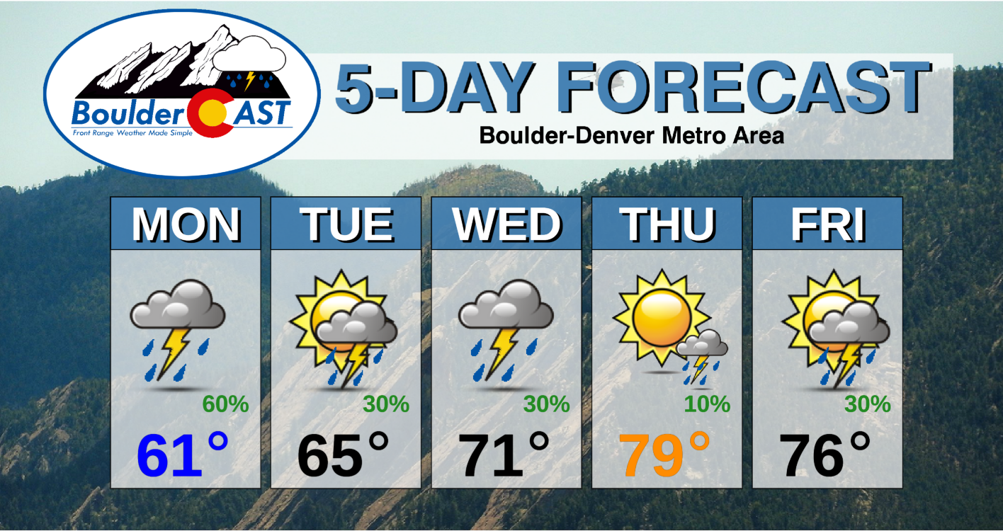
Monday: Overcast and cool with rain and thunderstorms likely in the afternoon into the late evening. Some storms could produce small hail and heavy rainfall. Highs near 60 degrees on the Plains and in the upper 40’s in the Foothills.
Tuesday: Partly to mostly cloudy with scattered showers and a few storms, mainly in the higher elevations. Highs in the middle 60’s on the Plains and lower 50’s in the Foothills.
Wednesday: Partly to mostly cloudy with widely scattered afternoon thunderstorms. Highs near 70 degrees on the Plains with middle 50’s in the Foothills.
Thursday: Mostly sunny, breezy and warm. There is a slight chance of a late-day thunderstorm, mainly across the higher elevations. Temperatures near 80 degrees on the Plains with middle 60’s in the Foothills.
Friday: More cloud cover and a better chance of late-day thunderstorms. Highs in the middle 70’s on the Plains with middle 60’s in the Foothills.
Mountains: In general it will be an unsettled week in the Mountains with daily chances for thunderstorms. Snow levels will range from 10-12k feet Monday and Tuesday with some light accumulations possible above treeline, but will lift above 12k feet Wednesday through Friday. Be aware of the lightning threat if you are headed to the Mountains this week! Temperatures will be below normal with light winds Monday and Tuesday, warming near or above normal Wednesday and beyond with increased south and southwest winds.

GFS model-derived snow level forecast for late day Tuesday
Help support our team of Front Range weather bloggers by joining BoulderCAST Premium. We talk Boulder and Denver weather every single day. Sign up now to get access to our daily forecast discussions each morning, complete six-day skiing and hiking forecasts powered by machine learning, first-class access to all our Colorado-centric high-resolution weather graphics, bonus storm updates and much more! Or not, we just appreciate your readership!
.
Spread the word, share the BoulderCAST forecast!
.


You must be logged in to post a comment.