
We start the week with near-record warmth with some locations reaching the lower 80s on Monday. That warmth vacates quickly come Tuesday with a strong storm system and associated cold front moving through. Rain and some thunder will change to wet snow Tuesday night. Another system approaches late in the week but its rain/snow potential looks much lower than the former storm. Read on for all the details of the weather week ahead.
This week’s highlights include:
- Record high temperatures possible on Monday in the upper 70s to lower 80s — Boulder’s record to beat is 78°F set back in 1986
- A strong storm system and associated cold front will lead to rain changing to snow late Tuesday into early Wednesday — only very light accumulations expected across the lower elevations
- Moderating briefly Thursday but staying near to below average for the remainder of the week
- Tracking another late-week system but it is weaker with marginal temperatures for snow — no major impacts expected

DISCLAIMER: This weekly outlook forecast is created Monday morning and covers the entire upcoming week. Accuracy will decrease as the week progresses as this post is NOT updated. To receive daily updated forecasts from our team, among many other perks, subscribe to BoulderCAST Premium.

Another fire in south Boulder
By now you’ve surely heard there was another wildfire in south Boulder this weekend. The NCAR Fire, as it has been named, ignited Saturday afternoon around 2:00PM near the NCAR Mesa Laboratory southwest of Boulder.

At the time the fire started, winds were gusting up to 50 MPH in the area forcing evacuations of more than 1000 residents in south Boulder as the movement of the wildfire could have been fast and erratic. Fortunately, unlike the recent Marshall Fire, Mother Nature was on our side this time around. Wind speeds relaxed quickly through the day and the fire was only able to spread to around 200 acres.

Thankfully no structures were lost and initial reports suggest this was mainly a grass fire and that many of the trees in the burn area may not be lost — a silver lining perhaps. The cause of the fire is still under investigation.
went on a hike … #NCARFire pic.twitter.com/9XVXKyDbZc
— Ben Holden 🇺🇸🇳🇴 (@benedictus_veni) March 26, 2022
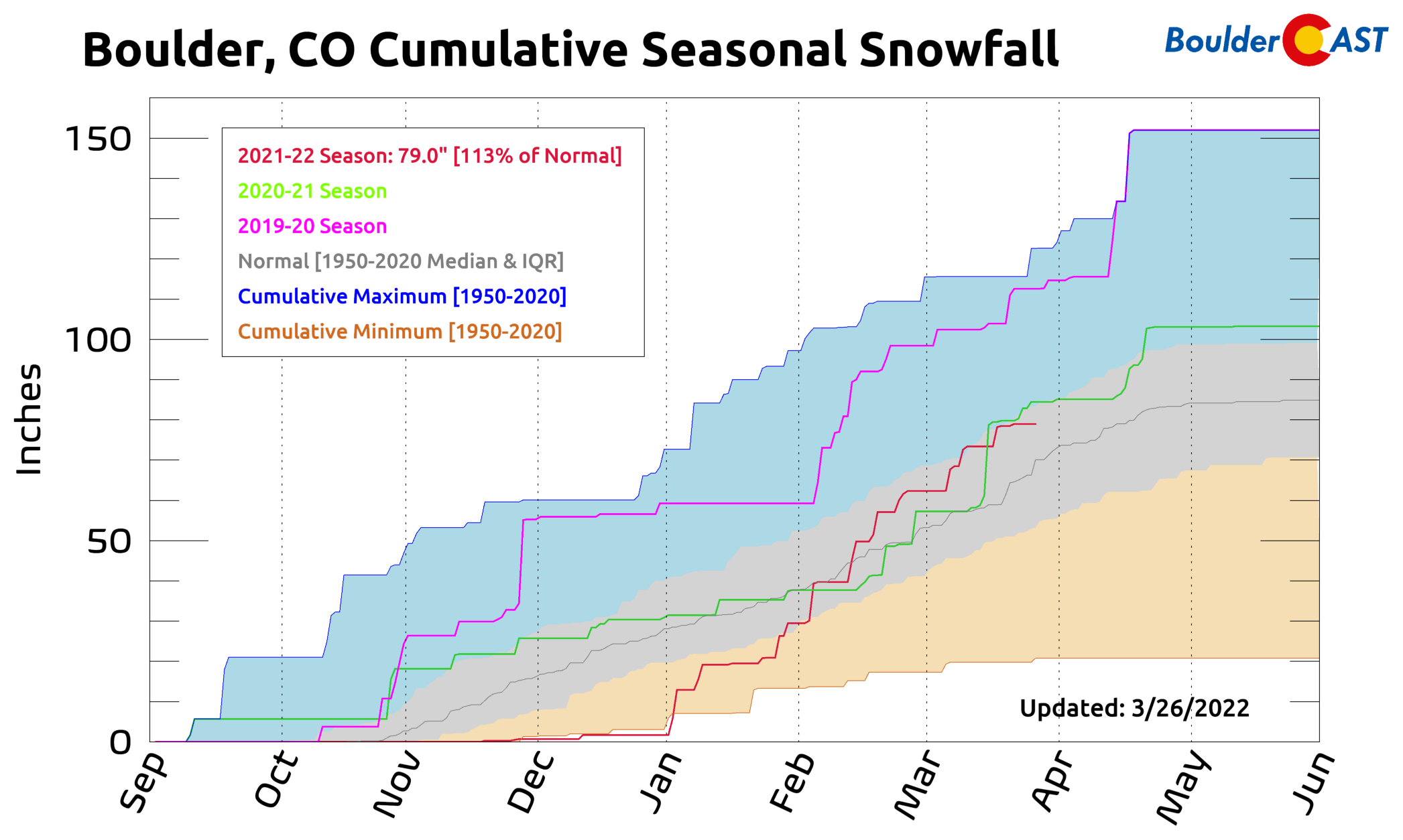
As you are probably aware, 2022 has been the snowiest start to a calendar year on record with more than 75 inches of snow falling over just the last three months in Boulder. This record-setting dump of moisture has helped to pull the entire Denver Metro area out of severe drought, but it wasn’t enough to prevent the NCAR Fire from starting or spreading in Boulder this weekend. This is largely because grassland fires in particular have little memory of the prior weather or drought conditions. After any snow cover melts away, it takes just a few warm and dry days for the grass to dry out and become very flammable when it’s still dormant. This is true whether or not any type of drought is ongoing (short or long-term). It only takes a single spark and a little wind to get grassland fires going in the dormant season. Unfortunately, we’ve had too much of both lately. Remember, the Table Mesa area of Boulder is one of the windiest in the entire Denver Metro area. These type of fires have been happening for a very long time in the Front Range. The main difference now is that they aren’t just burning themselves out across open grasslands — they’re butting right up against neighborhoods that weren’t there a few decades or even just a few years ago. With population continuing to explode in the area, there unfortunately isn’t a clear solution to this problem.
Near-record warmth on Monday
The week begins with what will be the warmest temperatures of the week. The mid-level pattern Monday afternoon features troughing over the eastern United States, with unseasonably cold temperatures in the Southeast producing late-season frost/freeze conditions. Out West, our ridge is pushing to the east as a strong storm system moves onshore into southern California. This system will be our weather-maker come Tuesday and Tuesday night — more on that a bit later.

With the ridge of high pressure at mid-levels still well entrenched across the eastern part of our state, the airmass has only continued to modify from yesterday. Deep southerly flow from Mexico is pushing north, as well as downslope flow from the western part of our state. The result is a broad area of well above average near-surface temperatures, with this warm air spreading into the upper Great Plains. We should easily reach the middle to upper 70s with even a few lower 80s in the sunnier spots. Boulder’s record high of 78°F set in 1986 is possibly up for grabs today — but similar to Sunday clouds will be the one factor that could prevent record warmth. Denver’s record high is 83°F which is less likely to be broken today.

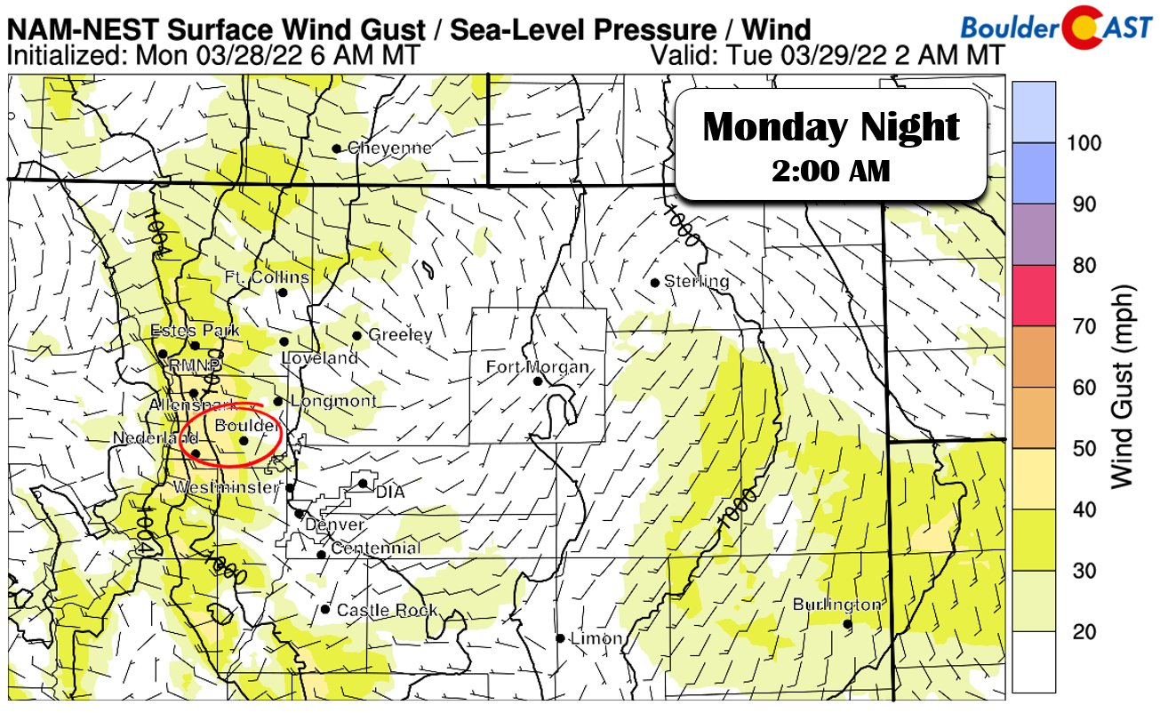
For the firefighting effort in Boulder, we’re expecting wind gusts to pick up during the day Monday to around 25 MPH out of the west and southwest near NCAR. Some high-resolution models, like the one below, are indicating west winds increasing Monday night with gusts in excess of 45 MPH around the active NCAR Fire area. Hopefully the fire is under better containment by then — t’s currently 35% contained as of early Monday morning.
Strong storm & cold front turns us unsettled Tue-Wed
Going into Tuesday and Wednesday, the aforementioned storm system moving in from southern California will be impacting our sensible weather during this period. The storm will move over the Intermountain West on Tuesday. As it further tracks east, it will transfer its energy downstream, with low-pressure development over Nebraska come Wednesday morning. The latest runs of the NAM/GFS/ECMWF have trended weaker in the wake of the system as it pulls east of Colorado into Nebraska. The older GFS solution showed a strong wake low pushing across north-central Colorado from the north with deeper mid-level forcing. With that largely absent now in recent model runs, most of our lift will be found late Tuesday through early Wednesday as the cold front moves through.

At the surface, Tuesday will start off mild again ahead of a southward moving cold front. A pre-frontal trough will pass through from the north during the afternoon, resulting in highs still above normal but only in the lower 60s. The cold front will move through Tuesday evening. Current model trends bring the cold front through the Denver Metro area between 3PM and 7PM on Tuesday. Near-surface temperatures will drop to near freezing late Tuesday night.

During the day Tuesday, as the trough sends mid-level energy across the state, surface heating combined with this will favor isolated to scattered rain or thundershowers in the afternoon and evening. There is marginal instability, enough for scattered rain activity and some isolated thunder.

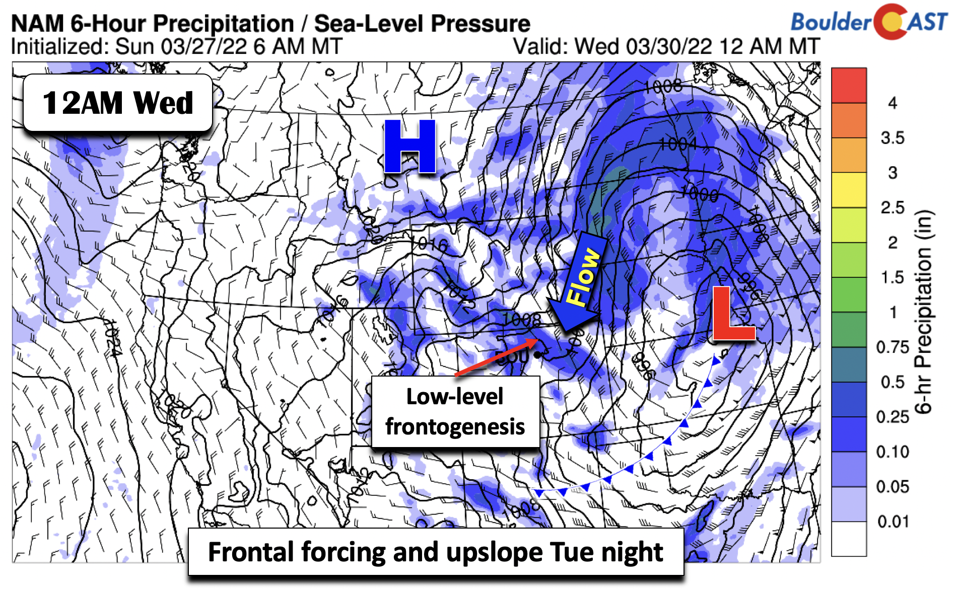
Our main precipitation period will be late Tuesday afternoon into early Wednesday. This will be associated with the cold front tied to low pressure development in eastern Nebraska/Kansas. The front will aid low-level frontogenetical forcing across the Plains, as well as a brief period of upslope from Denver to Boulder to Fort Collins. Some banded nature to the precipitation may occur in association with the front given weak instability, upslope, and frontal forcing.
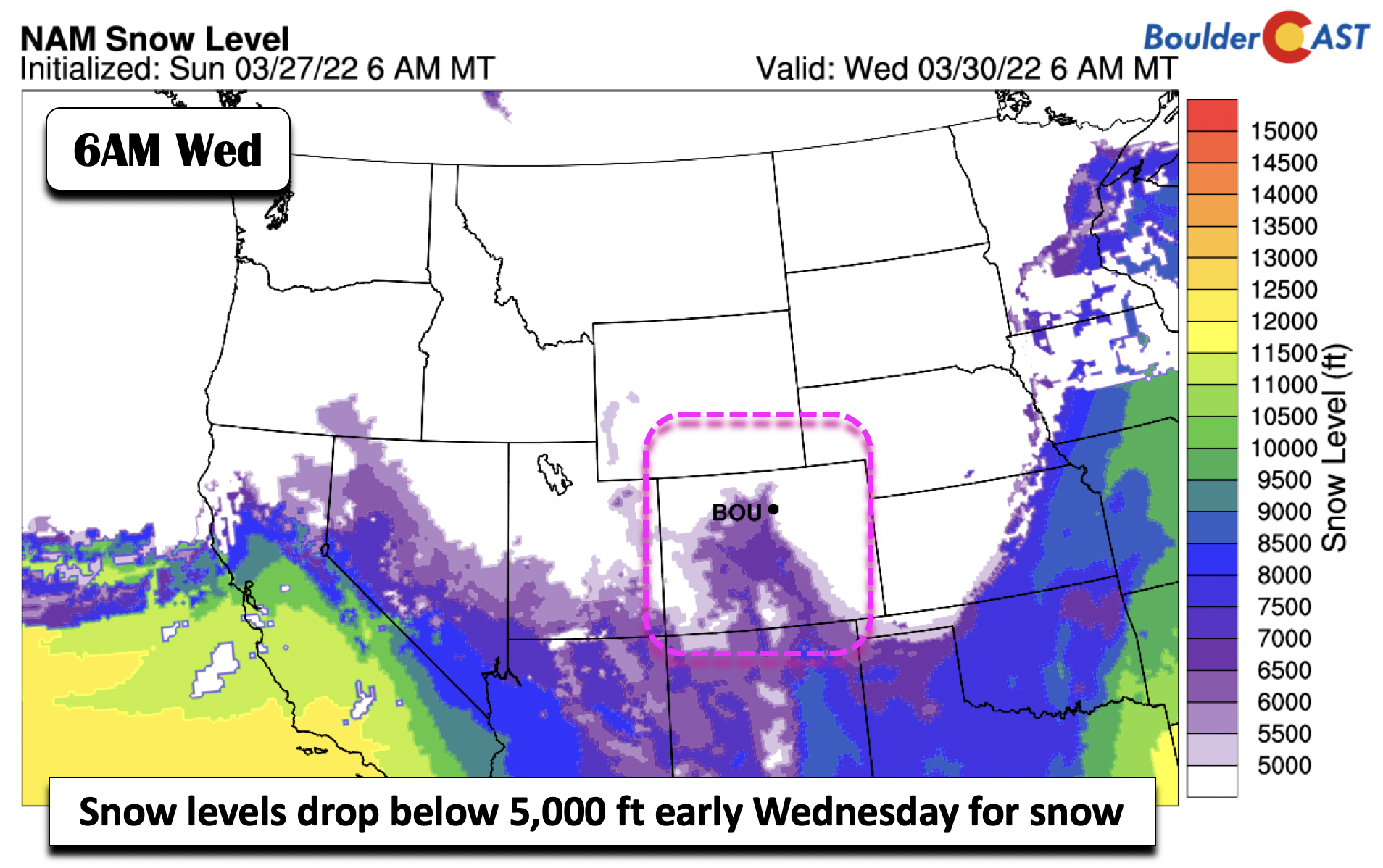
It appears that enough cold air will get drawn in behind the cold front to support snow levels dropping briefly below 5000 feet from late Tuesday night into mid-morning on Wednesday. Low temperatures should drop into the low to middle 30s across our area with 20s in the Foothills.
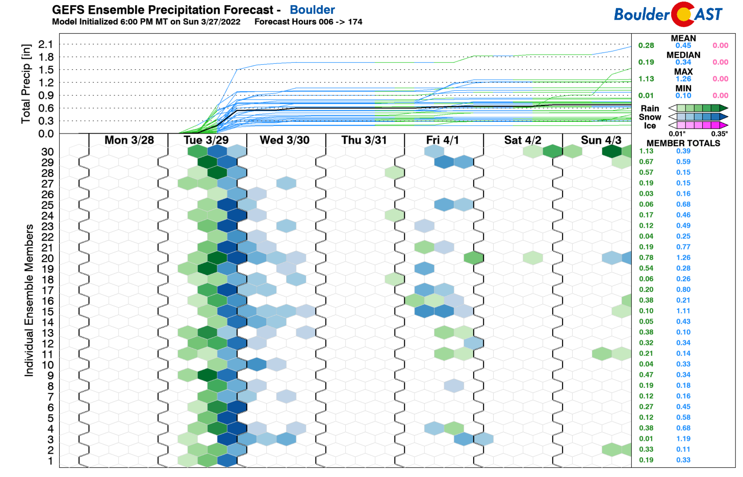
As we’ll discuss next with the ensemble data, the NAM snowfall amounts are more reasonable based on what we have looked at, with only light snow accumulations (generally <1 inch) across the area. Part of this has to do with the marginal surface temperatures following quickly behind the near-record warmth on Monday. The other part is this quick-moving system with only a 6 to 8 hour period of upslope and frontal forcing.

Taking a look at the ensemble probabilities for the region, there is good agreement that this will be a marginal snow event for the Plains, with the higher snow potential in the Mountains. For Boulder and Denver, the highest probabilities mainly favor light amounts in the 1 inch range, consistent with the NAM deterministic model above. Given this, we think this is a marginal event with most areas seeing 1 inch or less across the lower elevations, although higher amounts of a couple inches are likely over the Palmer Divide and Foothills.

Seasonal to end the week with a weak system
Wednesday will stay chilly as the system moves out in the middle of the day. Expect highs only in the upper 40s to around 50 for mid-week. A brief warmup is expected Thursday under weak ridging aloft, enough to bring temperatures back to normal in the upper 50s. By late week, the models continue to show another weak system traversing the region in the late Thursday to early Friday period. The previous GFS (below) was further south, with greater forcing over the Plains. The latest runs of the GFS and ECMWF are more muted and further north, indicating less overall sensible weather impacts.

Even without considering sensible weather impacts, the snow levels are more marginal, hovering around 5500 to 6000 feet, favoring a rain/snow mix over true accumulating snow for us.

Taking a look at the GEFS precipitation plumes, the late-week period agrees with our expected marginal impacts, with only a subset of ensemble members indicating precipitation. The ensembles are also mixed on snow potential given the above freezing temperatures. Nevertheless, this will continue to be monitored as we get closer, but for now we are not expecting anything impactful as highs remain chilly to end the week in the low 50s.
The weekend will feature a return of warmer weather with highs getting back into the 60s by Sunday.
Stay up to date with Colorado weather and get notified of our latest forecasts and storm updates:
Forecast Specifics:
Monday: Partly to mostly cloudy with near-record warm temperatures in the upper 70s to lower 80s across the Plains and upper 60s in the Foothills.
Tuesday: Overcast and cooler but still above average, with isolated to scattered rain/thundershowers in the afternoon/early evening. Highs in the upper 50s to low 60s on the Plains to the low 50s over the Foothills. Rain changes to snow late Tuesday night with overnight lows in the low to middle 30s. Less than 1″ of snow expected on the Plains with a couple inches possible in the Foothills.
Wednesday: A few lingering early morning snow showers followed by partly sunny skies. Highs in the upper 40s on the Plains and upper 30s in the Foothills.
Thursday: Partly cloudy and warmer with highs in the upper 50s to lower 60s on the Plains and near 50 in the Foothills. A chance of rain showers late.
Friday: A slight chance of rain or snow showers during the day (no accumulation), but otherwise partly sunny with highs in the lower 50s on the Plains and middle 40s over the Foothills.
Mountains: Warm temperatures will start over the mountains on Monday, along with increasing gustiness/clouds. Widespread snow will develop Tuesday into midday Wednesday with a strong storm system moving through. Snowfall amounts could approach a foot or more along and west of the Divide. A weak lull in precipitation is favored Thursday, along with a chance of light rain/snow late Thursday and into Friday.

Help support our team of Front Range weather bloggers by joining BoulderCAST Premium. We talk Boulder and Denver weather every single day. Sign up now to get access to our daily forecast discussions each morning, complete six-day skiing and hiking forecasts powered by machine learning, first-class access to all our Colorado-centric high-resolution weather graphics, bonus storm updates and much more! Or not, we just appreciate your readership!
Spread the word, share the BoulderCAST forecast!


You must be logged in to post a comment.