The week ahead will remain largely dry across the Front Range thanks to the slow passage of a strong ridge of high pressure aloft. Gusty downslope winds on Monday will relax and transition into a mid-week heatwave with record highs up for grabs across multiple days. However, unsettled weather is brewing for the upcoming weekend with decent rain chances for the lower elevations and a few snowflakes for the higher Foothills. Read on for all the details.
This week’s highlights include:
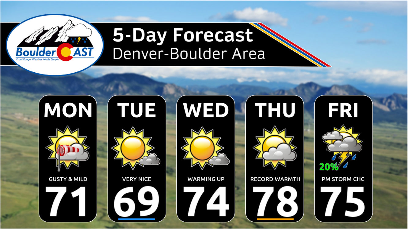
- Warm and Mostly Dry Week: The first week of spring begins with warm and mostly dry conditions in Colorado under high pressure aloft.
- Gusty Winds Monday: Brisk northwest flow and a mountain wave will bring gusty winds to the region Monday, with elevated fire danger, though conditions fall short of Red Flag Warning criteria.
- Heatwave Midweek: Record-breaking temperatures are possible on Wednesday and Thursday when our readings will soar well into the 70s and even close to 80 degrees in some areas.
- Unsettled Weekend Ahead: A pattern shift is expected Friday into the weekend with a chance of rain showers and storms late Friday into Saturday, with possible light snow accumulations in the higher Foothills. The weekend will be cooler with a chance of rain both days.
DISCLAIMER: This weekly outlook forecast is created Monday morning and covers the entire upcoming week. Accuracy will decrease as the week progresses as this post is NOT updated. To receive daily updated forecasts from our team, among many other perks, subscribe to BoulderCAST Premium.

Go Premium, get all the perks.
Daily Forecast Updates
Get our daily forecast discussion every morning delivered to your inbox.
All Our Model Data
Access to all our Colorado-centric high-resolution weather model graphics. Seriously — every one!
Ski & Hiking Forecasts
6-day forecasts for all the Colorado ski resorts, plus more than 120 hiking trails, including every 14er.
Smoke Forecasts
Wildfire smoke concentration predictions up to 72 hours into the future.
Exclusive Content
Weekend outlooks every Thursday, bonus storm updates, historical data and much more!
No Advertisements
Enjoy ad-free viewing on the entire site.
A warm & mostly dry first week of spring
As of Monday morning, GOES-East satellite imagery shows brisk northwest flow streaming into Colorado alongside an embedded jet streak. There is a minor amount of moisture within this flow which has led to the development of a few light snow showers in the Mountains and also some regional wave clouds overnight.
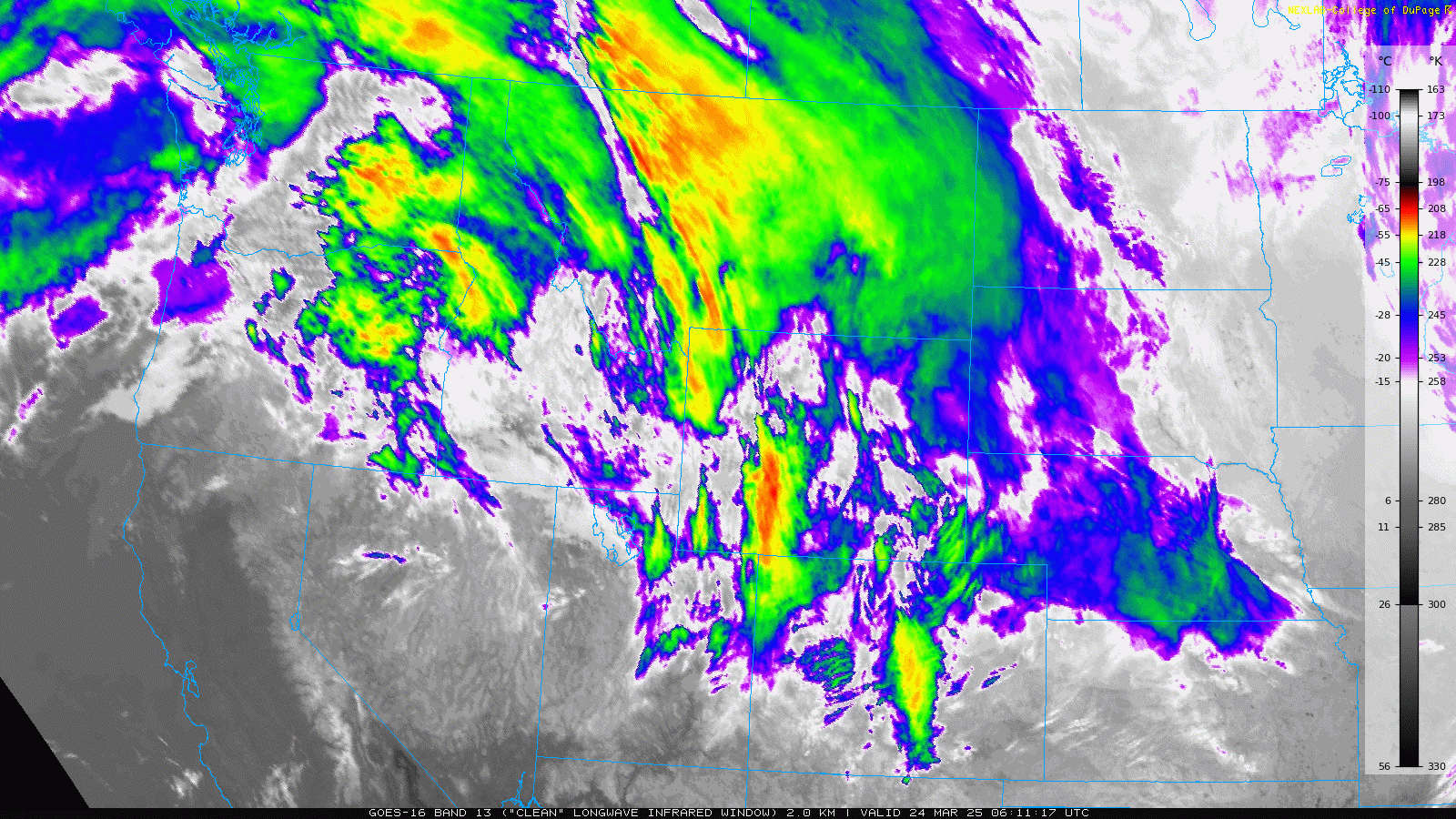
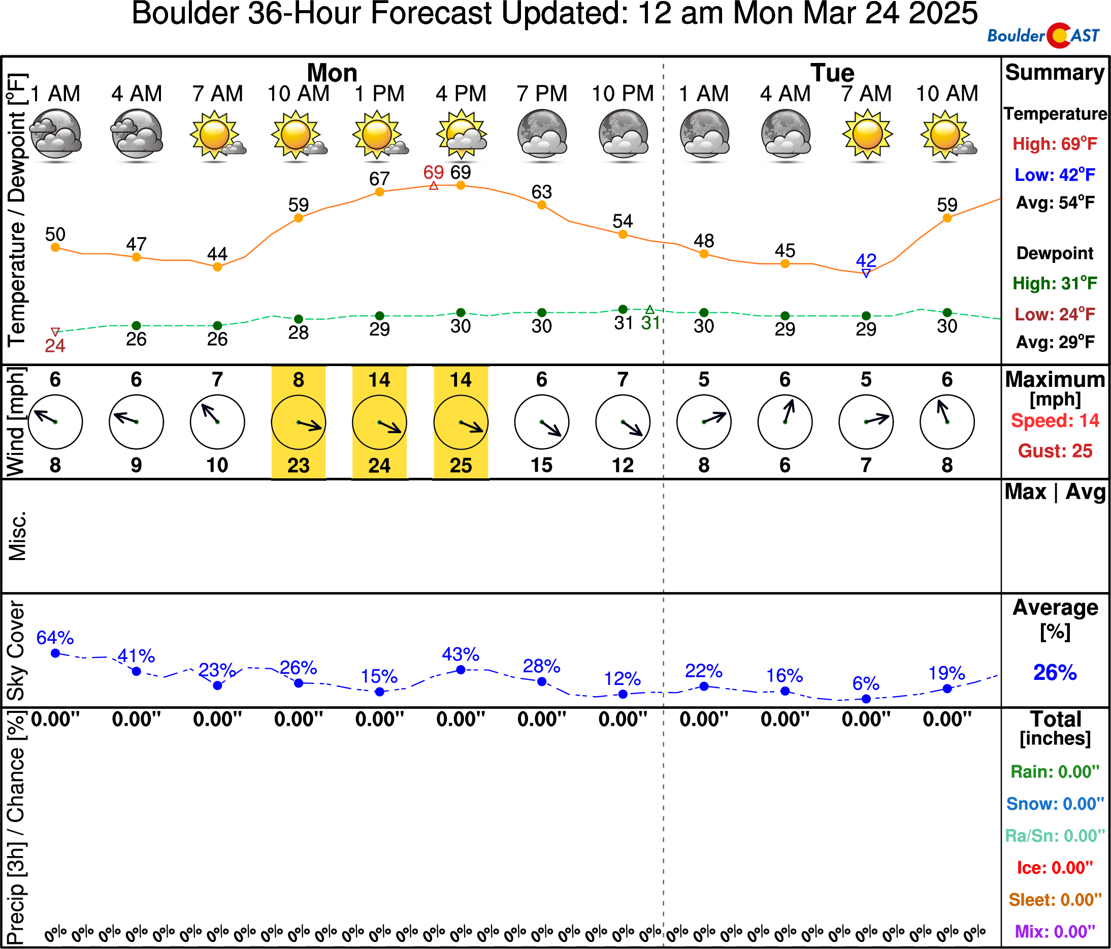
Snow will end early Monday morning in the High Country, but the wave clouds won’t go away as quickly— there will be some wave clouds or lenticulars populating our Monday skies. Expect partly to mostly sunny conditions with high temperatures right around 70 degrees to start the week.
A less-than-ideal mountain wave briefly developed early Monday morning before sunrise, with at least one gust around 85MPH noted up the hill at the Mesa Lab in Boulder (see below). Winds have also stirred up down in the city, but nothing too bad with just one or two rogue gusts over 40MPH observed so far.
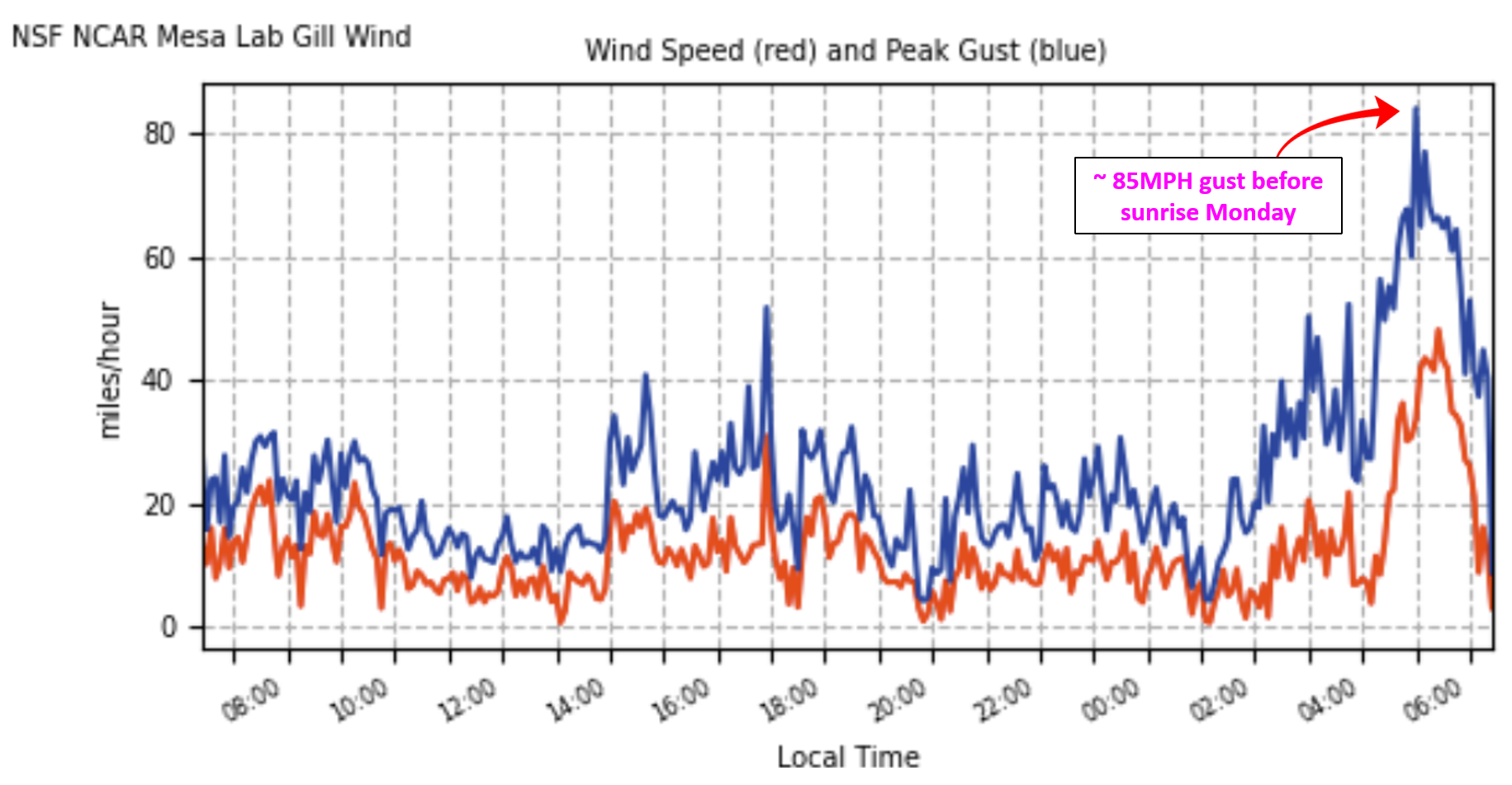
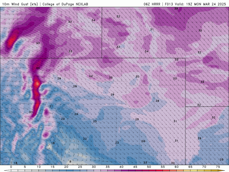
This mountain wave setup will quickly break down Monday morning, with gusty winds spilling out across the lower elevations the rest of the day. A few gusts over 40 MPH may occur in the far western Denver Metro area Monday morning (Boulder, Rocky Flats, Broomfield), but otherwise, widespread gusts of 15 to 30 MPH will be around in most areas through the day, weakening after sunset Monday evening. This will create elevated fire danger for the area, but not quite meeting the humidity or wind thresholds required for Red Flag Warnings. The animation below shows forecast surface wind speeds on Monday from the HRRR model:
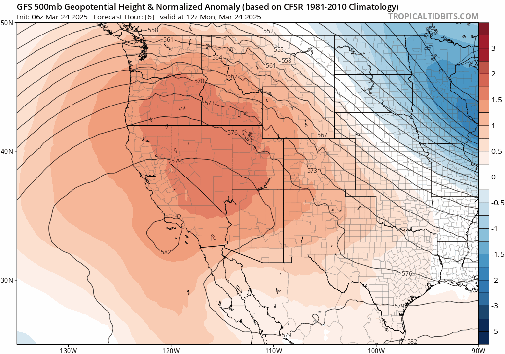
The aforementioned northwest flow pattern will remain over the state throughout the early week as a strong ridge of high pressure approaches from the West Coast, though winds aloft will be weakening heading into Tuesday. By Wednesday and Thursday, this strong ridge will be squarely centered over the Rockies, with Colorado under the influence of increasingly warm west and southwest downslope flow. The evolution of the ridge through the week is shown in the GFS 500mb height anomaly forecast animation below which runs from Monday through Friday evening. Notice that, at the very end of the animation, the ridge breaks down and is replaced by weak troughing from the west — this pattern shift will bring unsettled conditions Friday into the weekend for us. More on that in a moment.
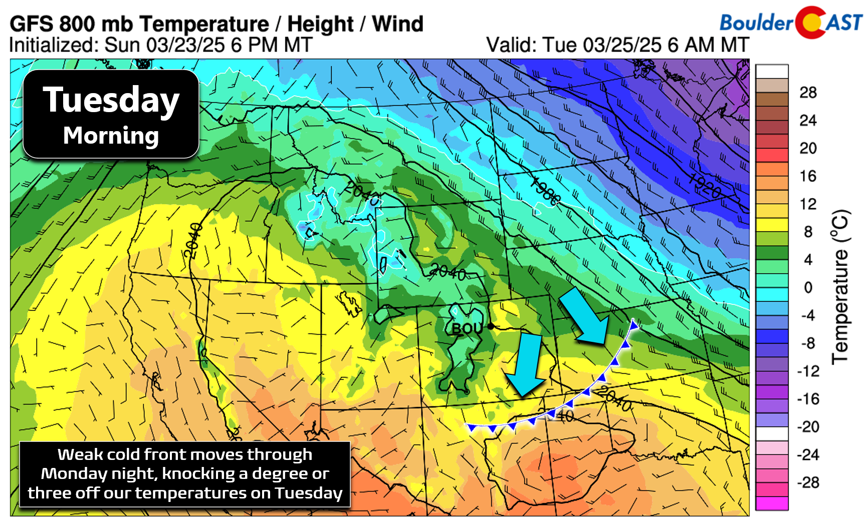
For Tuesday, temperatures will be a few degrees cooler than Monday following the passage of a weak cold front Monday night — more of a slight wind shift than anything. Highs will reach the upper 60s with much calmer winds and mostly sunny skies.
Wednesday and Thursday will see the ridge located directly across Colorado with the warmest airmass yet in 2025 overhead.
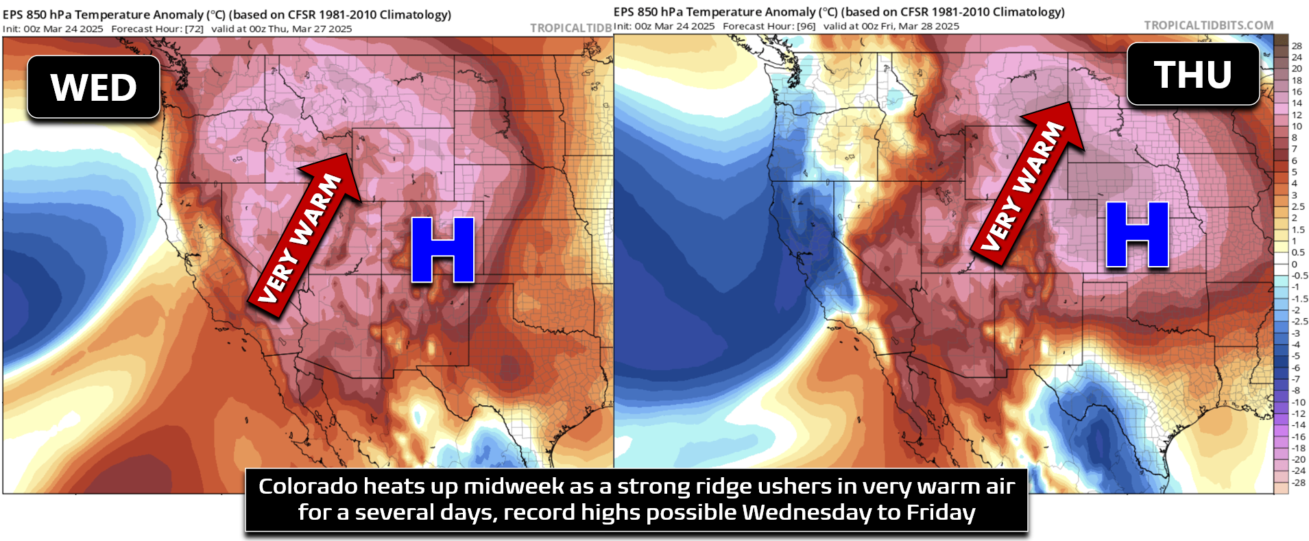
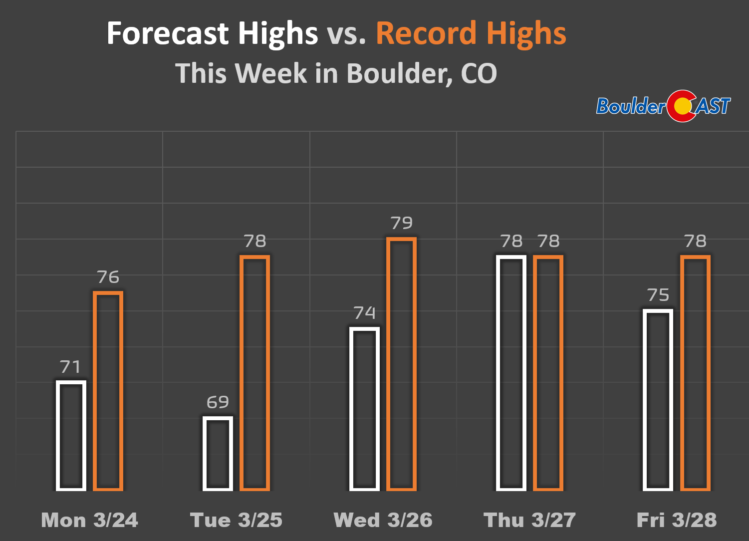
Temperatures will soar into the middle to upper 70s from mid- to late-week, with record highs possible during this multi-day “heatwave”, especially Thursday and possibly again on Friday. The graphic below compares the BoulderCAST forecast highs (white) to existing record highs (orange) in Boulder this week:
Unsettled weekend weather brewing
There’s still a fair amount of variation in our expected weather heading into the weekend, but one thing is for certain, the big toasty ridge from the week will be breaking down and scooting off to our east, with a trough entering the picture in its wake. By all accounts, the incoming disturbance won’t be terribly potent, but it is currently forecast to track squarely across Colorado as it passes through. This should bring us a decent chance of showers and storms beginning late on Friday, with those chances continuing into Saturday. Current ensemble trends indicate about 0.20 to 0.40″ of liquid for the area with this trough, almost exclusively in the form of rain for the lower elevations.
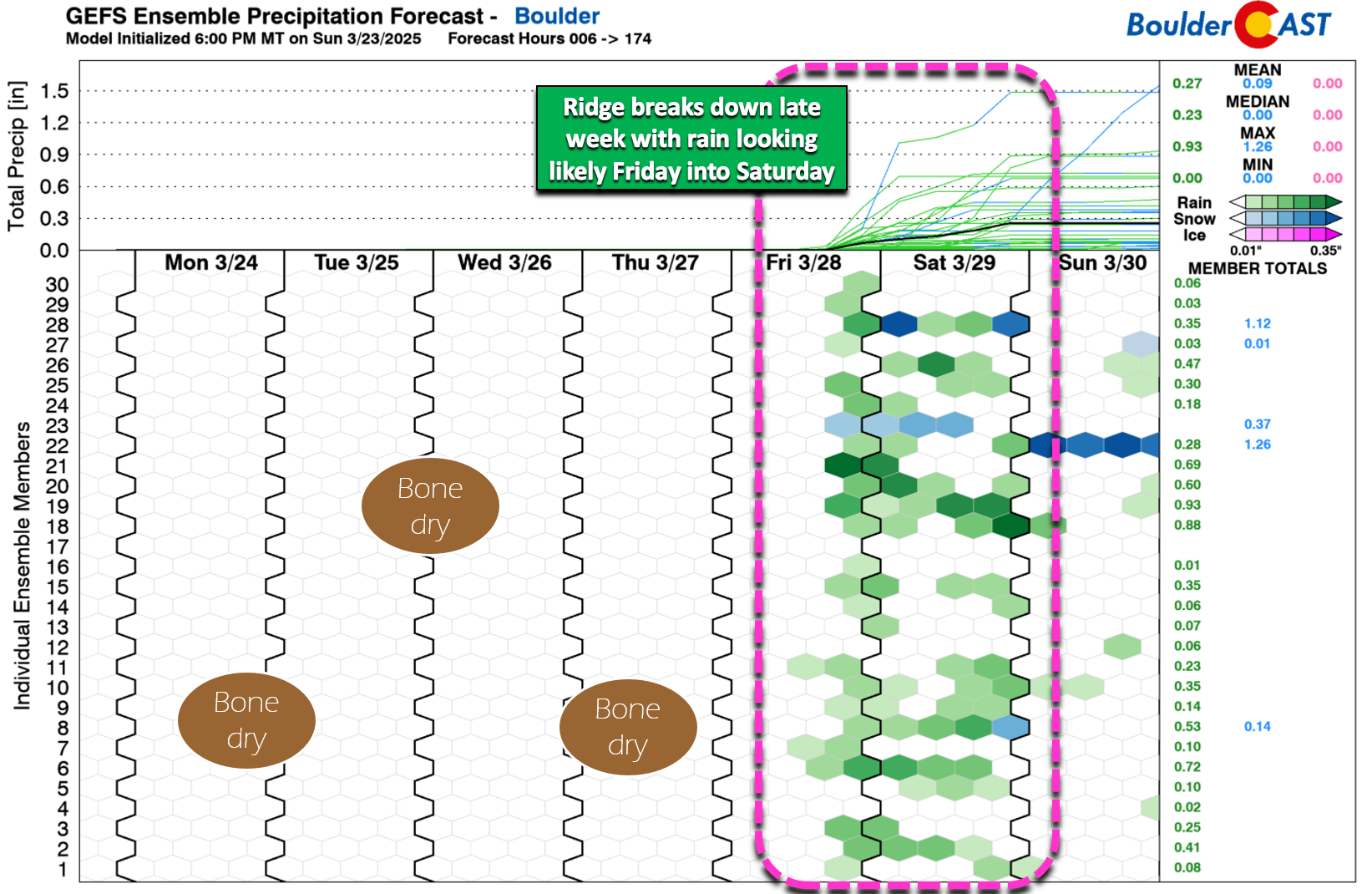
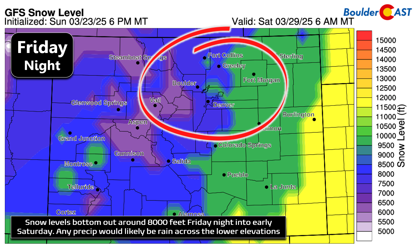
We will note there are some outlier runs hinting at a colder storm capable of supporting wet snow, even on the Plains, but those are few and far between with little hope of that actually materializing as of now. Most guidance keeps snow levels at or above 8000 feet Friday night through Saturday, which may allow for some minor snow accumulations in the higher Foothills.
Friday will still be very warm with highs in the 70s — possibly near record territory again, depending on the amount of cloud cover and the cold frontal timing — with a few late-day storms possible.
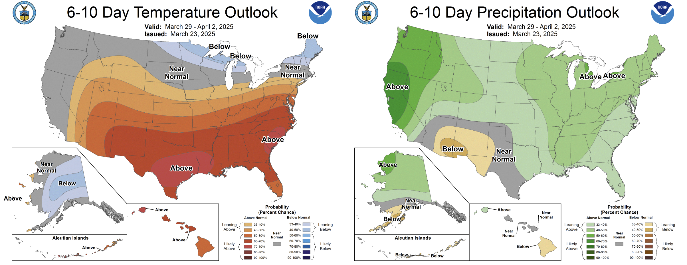
The unsettled pattern will continue through the weekend into early next week. Despite early signs that Pacific-sourced troughing will linger across the Rockies, there’s not a lot of cold air in the extended which would lend to any precipitation falling in the form of rain, not snow, for the lower elevations. The Climate Prediction Center is leaning warm and wet for Colorado the final days of March (this weekend) into early April — just what we need considering how dry is has been of late!
Enjoy this final week of March and first week of spring!
![]()
Forecast Specifics:
Monday: Partly to mostly sunny with some wave clouds mixed in. Downslope winds up to 50 MPH possible in and around Boulder in the morning, with widespread gusts up to 30 MPH possible for the entire area during the day. Fire danger will be elevated but not critical. High temperatures reach right around 70 degrees on the Plains with upper 50s in the Foothills.
Tuesday: Quiet and pleasant with mostly sunny skies and light winds. Temperatures top out in the upper 60s on the Plains with upper 50s in the Foothills.
Wednesday: Warmer and mostly sunny. Highs reach the middle 70s on the Plains with lower 60s in the Foothills.
Thursday: Even warmer with near-record highs possible as we soaring into the upper 70s to near 80 degrees in the Denver Metro area. The Foothills will reach the mid to upper 60s.
Friday: Mostly cloudy but still very warm. Highs top out in the 70s, with record highs possible. A few spotty late-day storms may develop during the late afternoon or evening, with a better chance of rain showers Friday night through Saturday. The higher Foothills may see light accumulating snow.
Weekend: Unsettled conditions with a good chance of showers during the day Saturday under mostly cloudy skies. Sunday should be drier but still with a slight chance of showers or storms around. Weekend temps will be in the 50s to lower 60s.
Get BoulderCAST updates delivered to your inbox:
DISCLAIMER: This weekly outlook forecast is created Monday morning and covers the entire upcoming week. Accuracy will decrease as the week progresses as this post is NOT updated. To receive daily updated forecasts from our team, among many other perks, subscribe to BoulderCAST Premium.
Go Premium, get all the perks.
Daily Forecast Updates
Get our daily forecast discussion every morning delivered to your inbox.
All Our Model Data
Access to all our Colorado-centric high-resolution weather model graphics. Seriously — every one!
Ski & Hiking Forecasts
6-day forecasts for all the Colorado ski resorts, plus more than 120 hiking trails, including every 14er.
Smoke Forecasts
Wildfire smoke concentration predictions up to 72 hours into the future.
Exclusive Content
Weekend outlooks every Thursday, bonus storm updates, historical data and much more!
No Advertisements
Enjoy ad-free viewing on the entire site.
Enjoy our content? Give it a share!


You must be logged in to post a comment.