
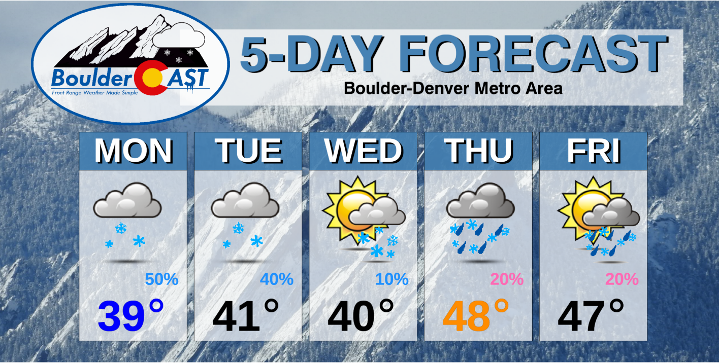
As widespread light snow fizzles out Monday morning, we look ahead to an overall unsettled week filled with additional chances for rain and accumulating snow. Our focus in the near-term aims at the potential for convective snow showers Tuesday and Tuesday night. Beyond that, rain/snow will stick with us through the end of the week with temperatures remaining below normal.
This week’s highlights include:
- Light snow tapers off slowly through Monday morning with less than 1″ of additional accumulation expected
- The week ahead remains unsettled with a persistent trough across the West and an active storm track riding into Colorado
- Another round of snow is expected Tuesday evening and night with light accumulations, mainly in the western Metro area
- Temperatures remain below normal through the entire week with continued chances for rain and snow Thursday and Friday
DISCLAIMER: This weekly outlook forecast is created Monday morning and covers the entire upcoming week. Accuracy will decrease as the week progresses as this post is NOT updated. To receive daily updated forecasts from our team, subscribe to BoulderCAST Premium.

Snow gives way to… more snow?
While light snow continues to fall across the Front Range as of early Monday morning, it will be wrapping up soon as the responsible weather system departs the area. Snow totals thus far look to be about 4″ around Boulder, close to 5″ in Denver, and upwards of 8″ in southeastern portions of the Metro area near Parker. For a look at the latest snowfall totals, go here.
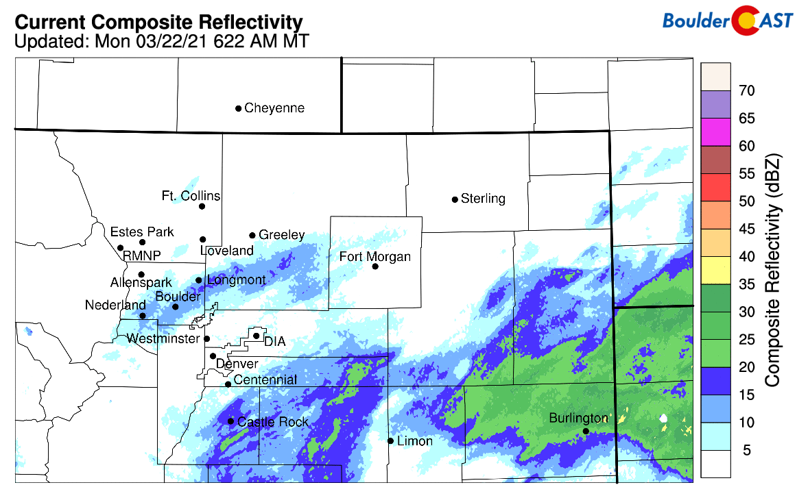
Radar animation ending Monday morning at 7:15AM
GOES-East infrared satellite imagery gives us a broad view of the ongoing winter storm. The center is currently located in northeastern Arizona. The back edge of the lift and moisture will be exiting our area by evening. High-resolution models are showing a few pop-up snow showers Monday afternoon in and near the Foothills, so don’t be surprised if you see more snowflakes falling through the day Monday. Additional accumulations will be light though, less than 1″ across the Plains and less than 2″ in the Foothills.
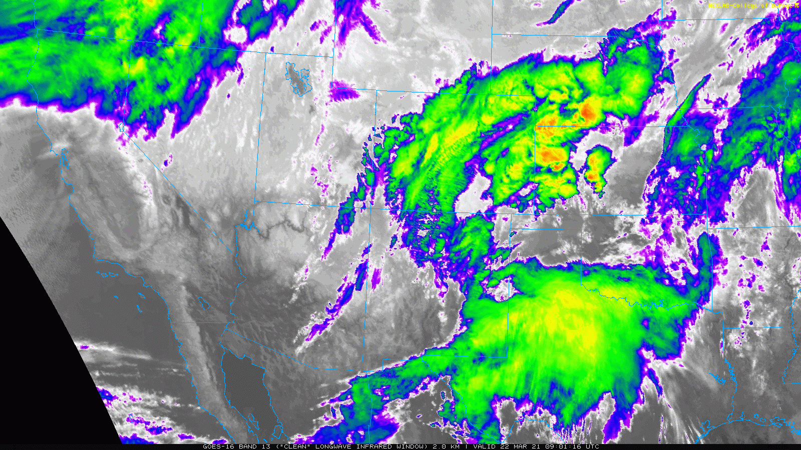
GOES-East infrared satellite animation from Monday morning
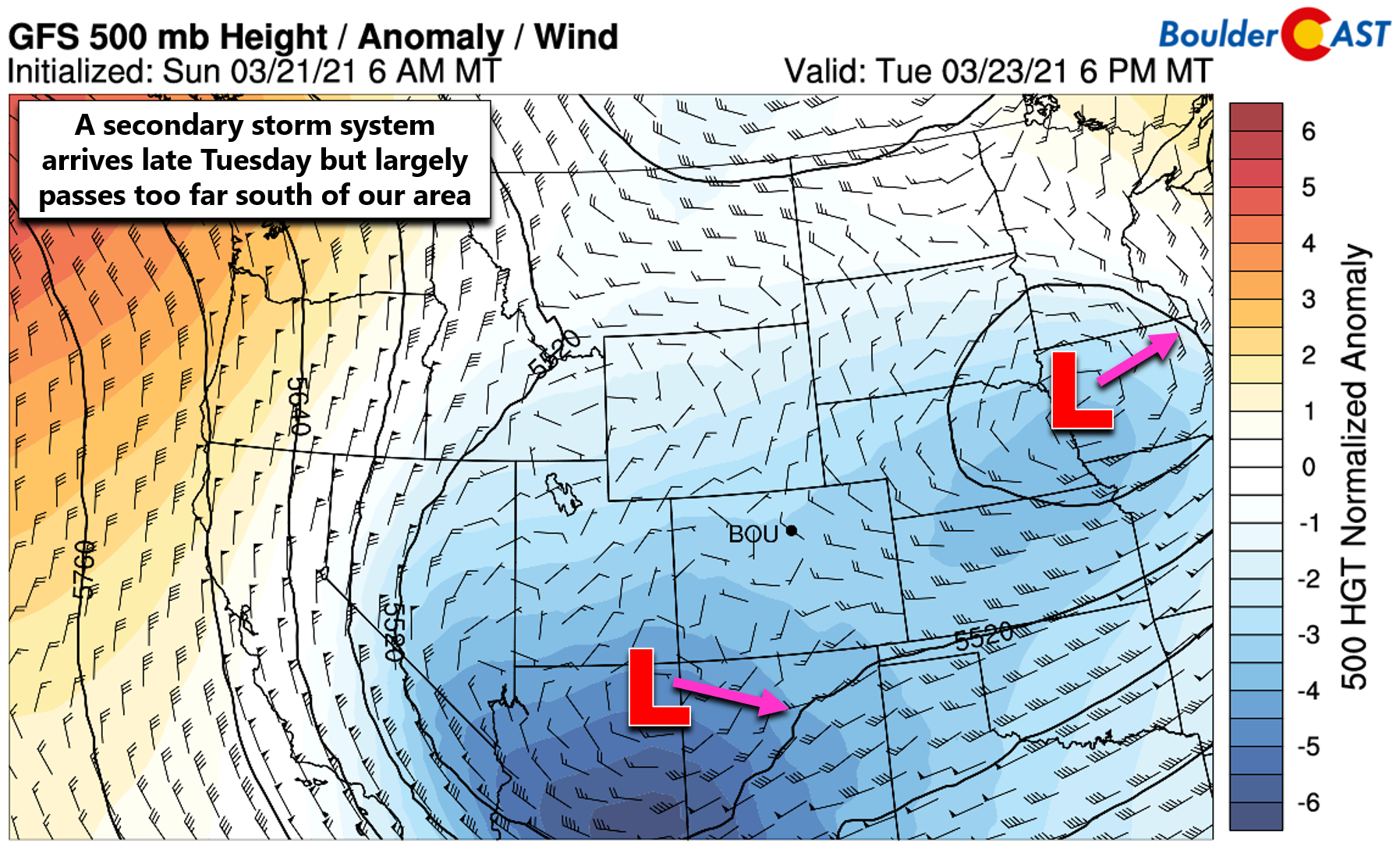
In the wake of the departing storm, an active pattern will remain across Colorado this week thanks to a large-scale persistent trough across the area. In addition, an amplified ridge over the northeast Pacific Ocean will continue to help funnel the storm track directly into the central and southern Rockies this week. The GFS 500mb height anomaly forecast animation below spans from Monday morning through Friday night. We won’t be escaping this trough nor the associated unsettled weather it will bring anytime soon!
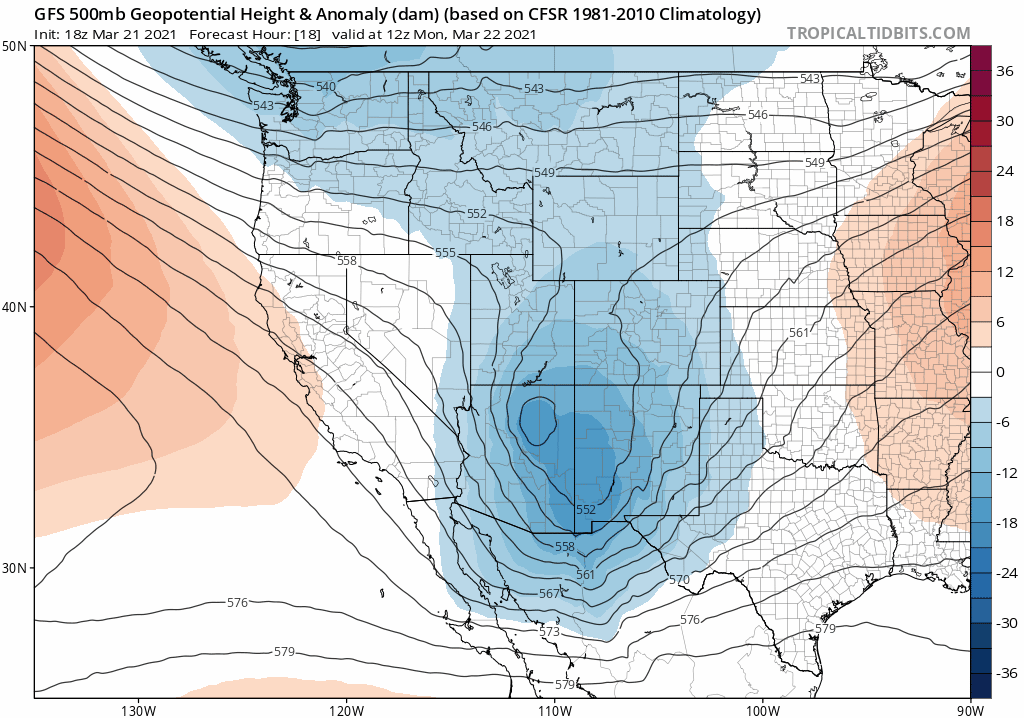
GFS 500mb height anomaly forecast animation spanning from Monday morning until Friday night.. A trough remains across Colorado with frequent waves bringing unsettled weather.
After the last of the snow tapers off Monday morning, the rest of Monday and early Tuesday will be comparatively tranquil as we will sit between storm systems with fairly calm conditions. Highs Monday will be in the upper 30’s, with lower 40’s on Tuesday. Both of these values are well below normal for late March.
The next weather feature will dive southward quickly and reach to the Four Corners by Tuesday evening. This system looks to develop into a compact cut-off low and is forecast to move eastward across northern New Mexico Tuesday night into Wednesday. In the last day or so, the track of this system has shifted further south in the models but the Denver Metro area will still likely see a period of snow showers from this. Impacts will be most substantial in the Mountains and Foothills, however.
Across the lower elevations, we could see a couple of inches of snow, particularly in the western and southern Denver area from Tuesday afternoon into Wednesday morning. Models indicate a convective element to these snow showers which will form in and near the Foothills. While snowfall rates in these convective cells would be high, they should be fairly spotty which will help to keep snow totals down. We’ll likely post an update early Tuesday regarding this next shot of snow, so check back then.
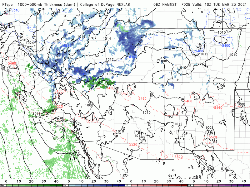
3km NAM precipitation forecast animation spanning from Tuesday morning into Wednesday afternoon. Some snow will be possible in the western and southern Metro area, but most energy is south of our area
Remaining unsettled through Friday
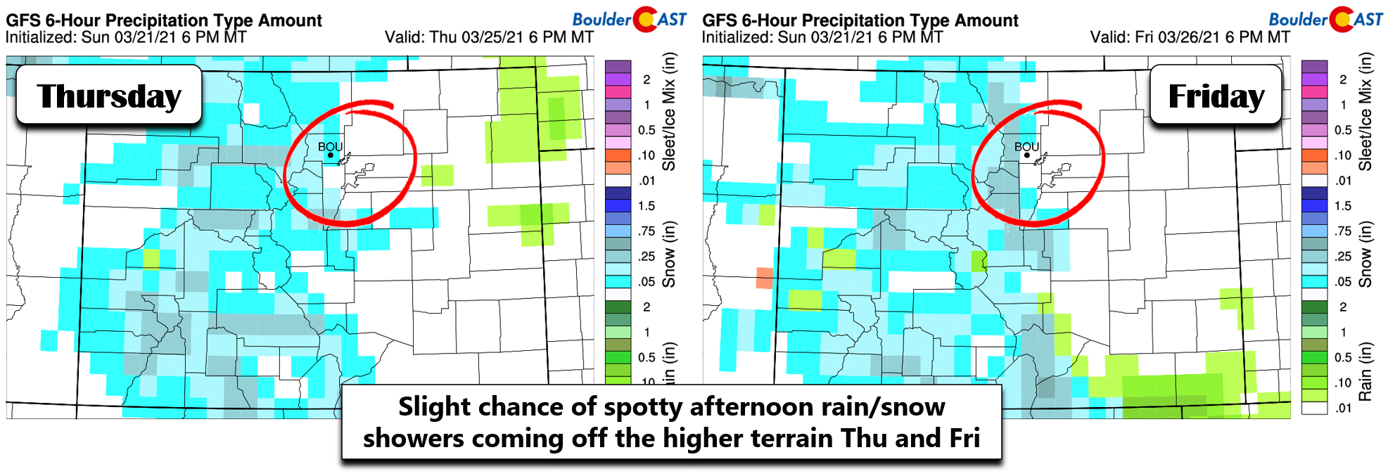
While it will warm-up into the mid to upper 40’s late in the week, the Front Range will remain just as unsettled with the trough persisting across the West. Both Thursday and Friday will offer a chance of rain and snow showers across the lower elevations. There is a good deal of model variation for this late-week timeframe, but nothing really stands out to us yet. That is, nothing organized enough to produce widespread upslope east of the Divide let alone much snowfall for our area. More than likely, we’d be looking at spotty convective rain/snow showers rolling off the higher terrain both days with minimal or no accumulation expected. There is a slight chance of something more substantial, however, but odds of that right now seem quite low.
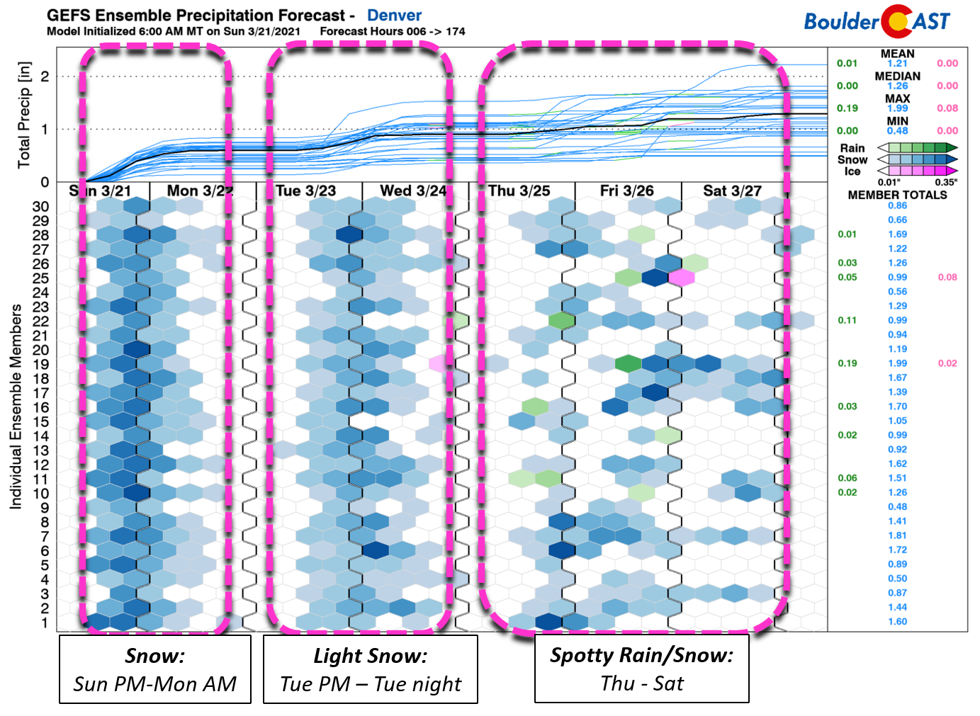
Our GFS ensemble precipitation plumes provide a nice summary of the whole week ahead and as you can see, we’ve got daily chances for precipitation. How about that!
As the slew of weak weather disturbances continue to evolve through the week, we’ll pass along updates as needed. We’re hopeful that something more substantial will surprise us given the active pattern. We need the moisture.
Forecast Specifics:
Monday: Light snow tapers off through the morning with mostly cloudy skies the rest of the day. There could be a few pop-up snow showers during the afternoon in and near the Foothills. Additional accumulations of 1″ or less. Highs near 40 degrees across the Plains with lower 30’s in the Foothills.
Tuesday: Partly cloudy early, then increasing clouds with a chance of convective snow showers from late afternoon into the overnight. Showers will be spotty but will have heavy snowfall rates. The focus will be across the western Metro area and Foothills with a trace up to a few inches of accumulation possible. Highs in the lower 40’s on the Plains and lower 30’s in the Foothills.
Wednesday: Possibly some lingering snow in the morning, but otherwise quiet with decreasing clouds through the day. Highs in the middle 40’s on the Plains and lower 30’s in the Foothills.
Thursday: Mostly cloudy with spotty rain and snow showers in the late-day period into the overnight. Highs in the upper 40’s on the Plains and middle 30’s in the Foothills.
Friday: A slight chance of rain/snow showers. Highs in the middle 40’s on the Plains and lower 30’s in the Foothills.
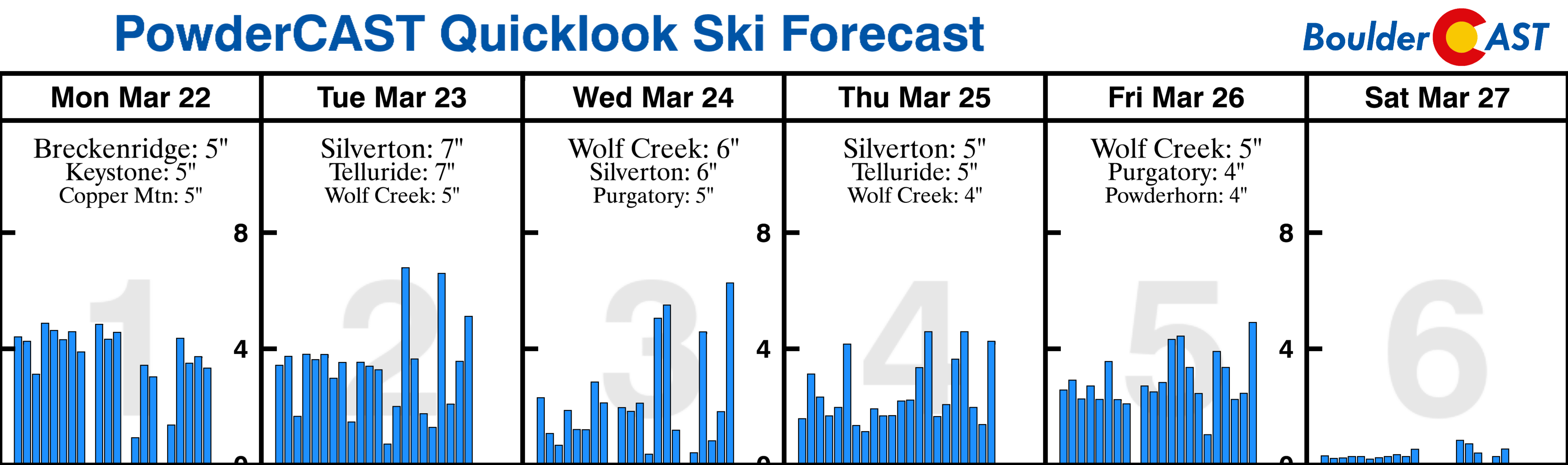
Mountains: Light snow showers will wind down by Monday afternoon, but return quickly on Tuesday and throughout the rest of the week with daily chances for snow showers capable of producing several inches of snow each day. There isn’t much organization to the snow showers. It will just be an unsettled weak in the Mountains with daily snow showers.
Help support our team of Front Range weather bloggers by joining BoulderCAST Premium. We talk Boulder and Denver weather every single day. Sign up now to get access to our daily forecast discussions each morning, complete six-day skiing and hiking forecasts powered by machine learning, first-class access to all our Colorado-centric high-resolution weather graphics, bonus storm updates and much more! Or not, we just appreciate your readership!
.
Spread the word, share the BoulderCAST forecast!
.


You must be logged in to post a comment.