June has begun exceptionally wet across the Front Range and that trend will live on this week with continued cool and rainy weather expected throughout the extended forecast. Wednesday and Thursday look to be the wettest days in the pipeline, but every single day this week will carry at least the risk of scattered storms alongside a minor risk of localized flooding. Things may finally dry out and warm up next week but don’t count on it. Read on for our complete outlook of the weather week ahead in Colorado.
This week’s highlights include:
- The Front Range has kicked off June with 1-3″ of rainfall already and that trend will continue…
- Two blocking patterns will hold across North America this week leading to more of the same cool and unsettled weather for our area
- Wednesday and Thursday are shaping up for the best rain chances, but every other day will have at least scattered showers and storms too
- Models differ on exact rainfall amounts this week, but we expect most areas will see at least 0.75″ to 1.5″ through Friday
- No severe weather to worry about, but localized flooding will be possible most days with the greatest risk in the burn scars
- The soggy pattern may finally let go next week with warmer weather and lesser rain chances
DISCLAIMER: This weekly outlook forecast is created Monday morning and covers the entire upcoming week. Accuracy will decrease as the week progresses as this post is NOT updated. To receive daily updated forecasts from our team, among many other perks, subscribe to BoulderCAST Premium.
Daily Forecast Updates
Get our daily forecast discussion every morning delivered to your inbox.
All Our Model Data
Access to all our Colorado-centric high-resolution weather model graphics. Seriously — every one!
Ski & Hiking Forecasts
6-day forecasts for all the Colorado ski resorts, plus more than 120 hiking trails, including every 14er.
Smoke Forecasts
Wildfire smoke concentration predictions up to 72 hours into the future.
Exclusive Content
Weekend outlooks every Thursday, bonus storm updates, historical data and much more!
No Advertisements
Enjoy ad-free viewing on the entire site.
A wet start to June
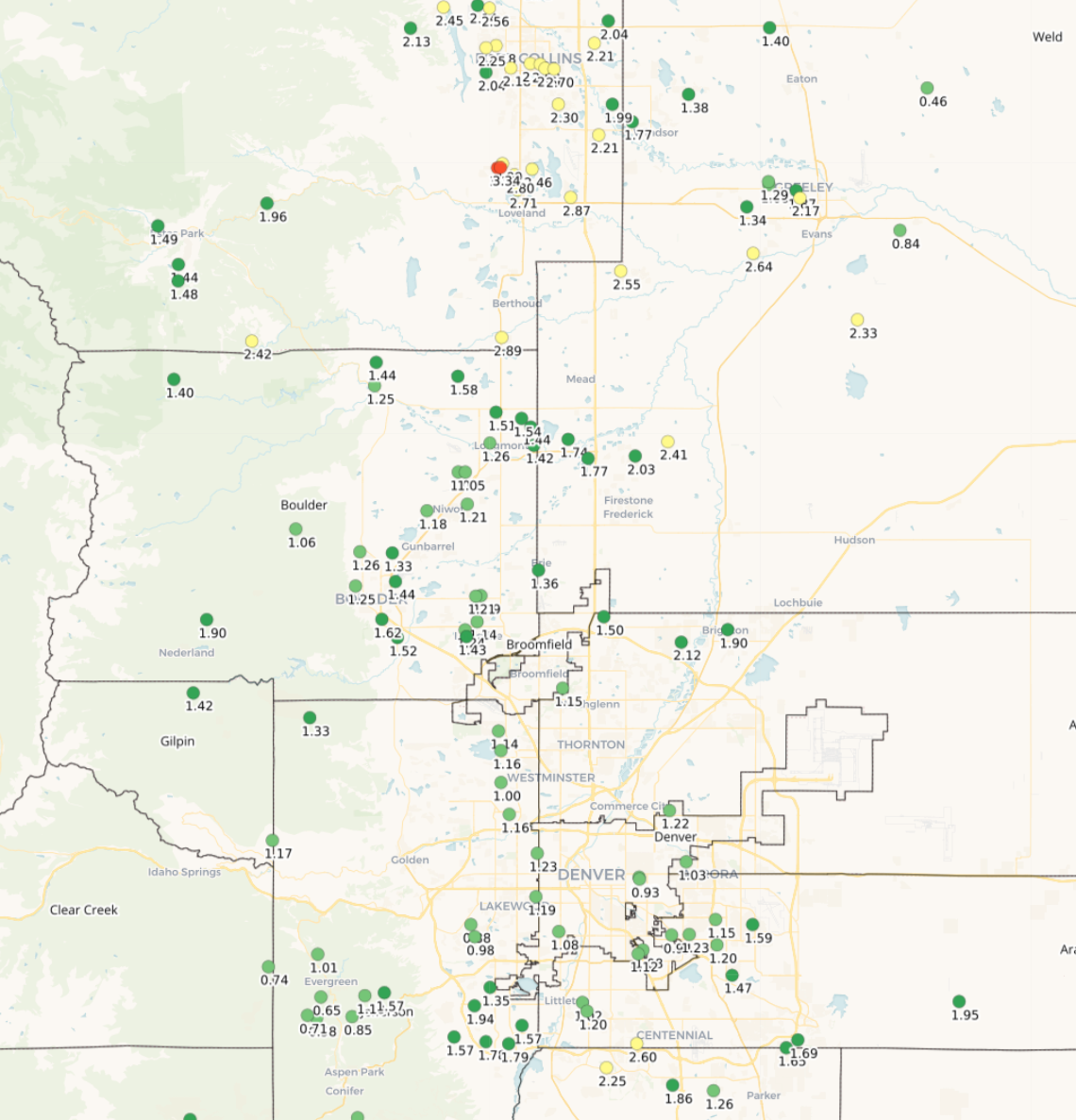
The slow-moving storm system and resulting wet pattern we talked about in last week’s Monday outlook has fully came to fruition, delivering rainfall about as expected in most areas with a slight over-production in spots. The map below shows rainfall totals for just the first five days of June. The Front Range as a whole has seen at least 1 to 2″ of rain already this month, with some luckier spots closer to 3″ around Loveland and Berthoud. These totals are all around the expected rainfall amount for the entire month of June and we still have 25 days to go!
Not as wet for the week ahead, but still wet
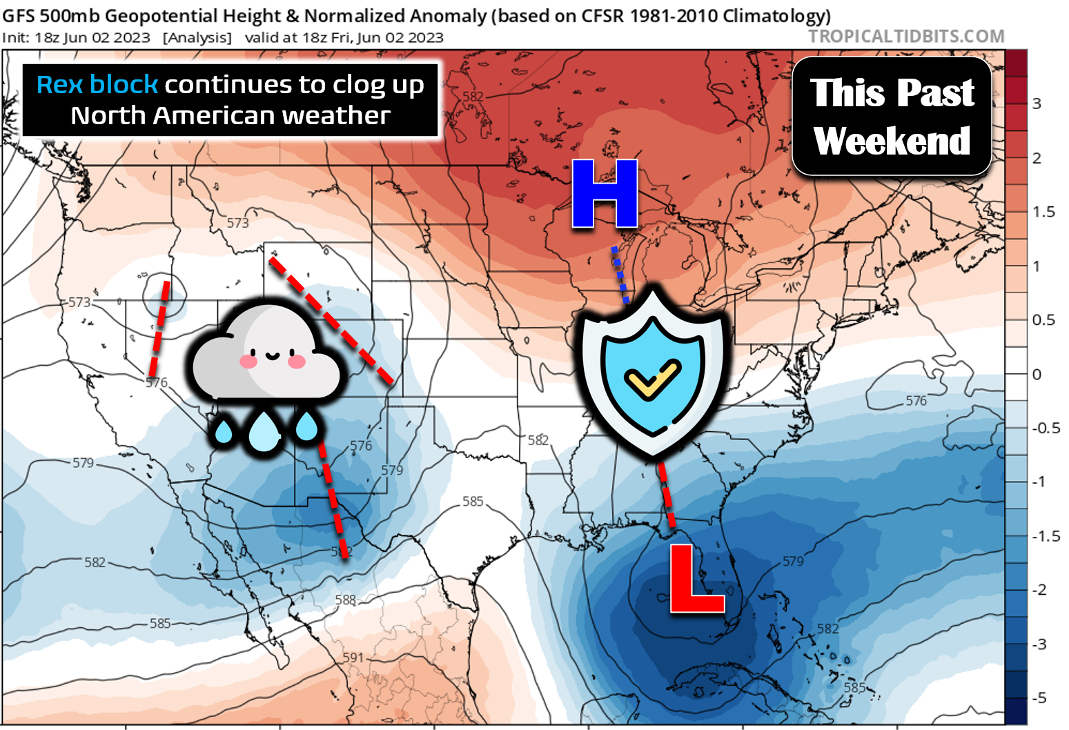
The week ahead will feature continued soggy weather across the Front Range, though not as soggy as it was this past weekend which saw all-day rain and drizzle engulfing the area. This persistently gloomy predicament we’re in across the West is due to a dominant “rex block” pattern which has clogged up the flow across North America for several days now. A “rex block” pattern consists of a strong area of high pressure directly poleward of a strong area of low pressure. Together these two opposing areas of pressure will take a long time to break down causing whatever is happening upstream to linger there as well. The 500mb map for this past Friday is shown below illustrating the block which resided over the eastern United States. The low pressure portion to the south helped spawn the Atlantic Basin’s first named tropical cyclone of the year in the Gulf of Mexico over the weekend (Tropical Storm Arlene). Further west, a persistent trough pattern allowed for the influx of Gulf of Mexico moisture and easterly flow into the Front Range producing widespread precipitation in our area.
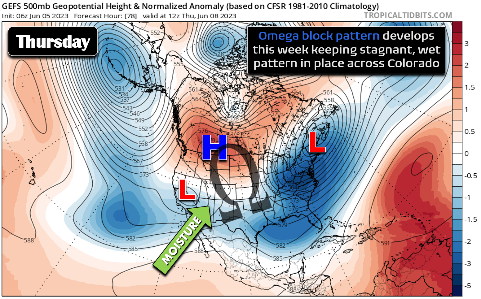
As the week ahead progresses, that pesky “rex block” pattern will finally breakdown (woohoo!), only to be replaced by an “omega block” pattern which will have an overall similar outcome for us — that being continued wet weather (boo!). If you recall, it was an “omega block” pattern which led to a rainy start to May in our area. It’s coming back for an encore performance here in early June it seems!
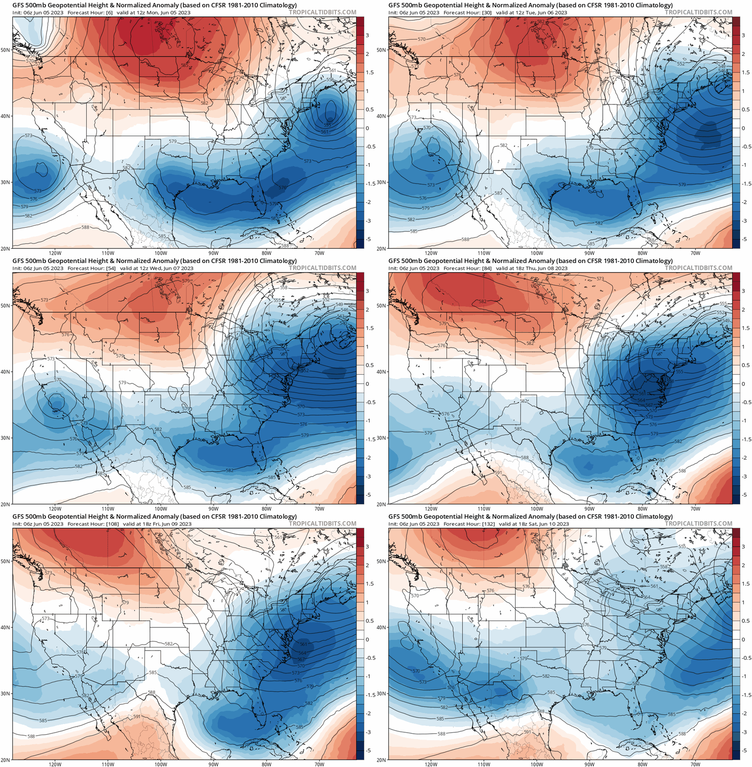
The GFS 500mb height anomaly forecast animation below takes us through the week into the upcoming weekend. The pattern across North America is a complex one, but just note that the overall broad setup remains unchanged throughout the next six days or so: a big trough across the East, a big ridge across central Canada, and weaker but persistent troughing over California. It is those three features that will define the omega block allowing for a continual flow of both moisture and shortwaves into the Rockies — and ultimately another rainy week here in the Front Range!
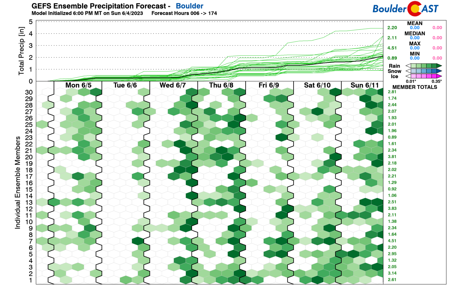
The GFS ensemble precipitation plumes are indicating daily chances for rainfall in our area this week, though there is clearly some ups-and-downs in those chances. Tuesday and Friday look to be the “driest” days, with Wednesday and Thursday shaping up for the best and most intense rainfall chances.
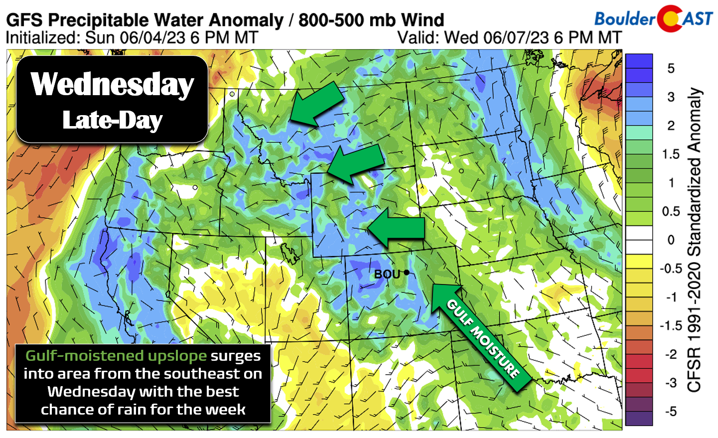
A look at the low-level pattern on Wednesday from the GFS and it is clear why it will be so dang wet — we’ll be tapping into a pipeline of moisture from the Gulf of Mexico… plus low- and mid-level upslope flow will be widespread. Similar to this past weekend, the surge will be coming in from the southeast so this should once again favor the northern Front Range from Boulder northward to Fort Collins for the most rain. This pattern will persist into early Thursday before winds reverse over the area leading to a “drier” and less stormy Friday.
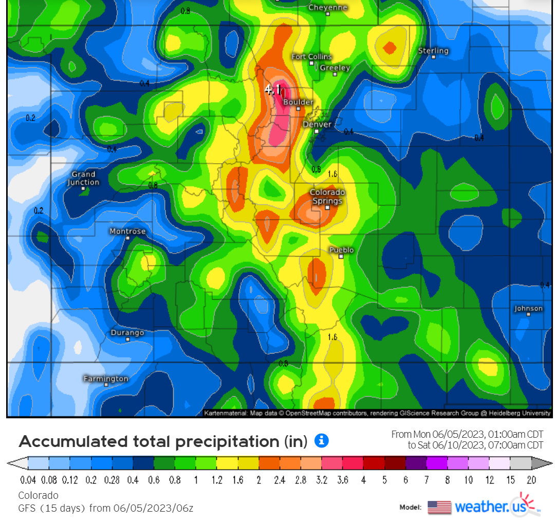
It’s important to highlight that there is notable disagreement in the models regarding how things play out later this week, especially Wednesday and beyond. This is no surprise given the reliance on a tricky transition from one blocking pattern to another. For example, the GFS model is currently the most bullish with much of our area seeing 1 to 3″ of rainfall through the week.
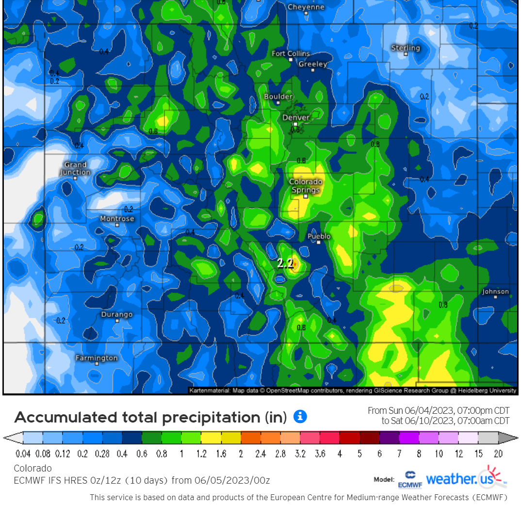
The Euro model is on the other end of the spectrum with definitively lower rainfall totals for the entire state. This seems to be tied to a more westward extension of weak ridging which the Euro has directly over Colorado mid to late week, with the best troughing remaining further to our west. We will say that the Euro model really underperformed on the wet weather this past weekend, with the GFS more accurately capturing just how wet it would be. Whether that translates into continued success for the GFS during the week ahead remains to be seen. The real outcome this week will probably land somewhere in between these two models with hopefully most areas seeing 0.75″ to 1.5″ of rain through Friday night (locally higher totals from any slow-moving thunderstorms).
As it stands now, it doesn’t look like there will be any chance of severe weather this week in our neck of the woods, and the risk of flooding should be on the lower side. We’re most concerned about the burn scars blowing out from localized heavy rain, especially Cameron Peak. Burn scar flooding will be a risk every single day with weak flow aloft and anomalous moisture in place. We’re not expecting any widespread flooding issues for the Denver Metro area as a whole despite continued rainfall onto already nearly saturated ground.
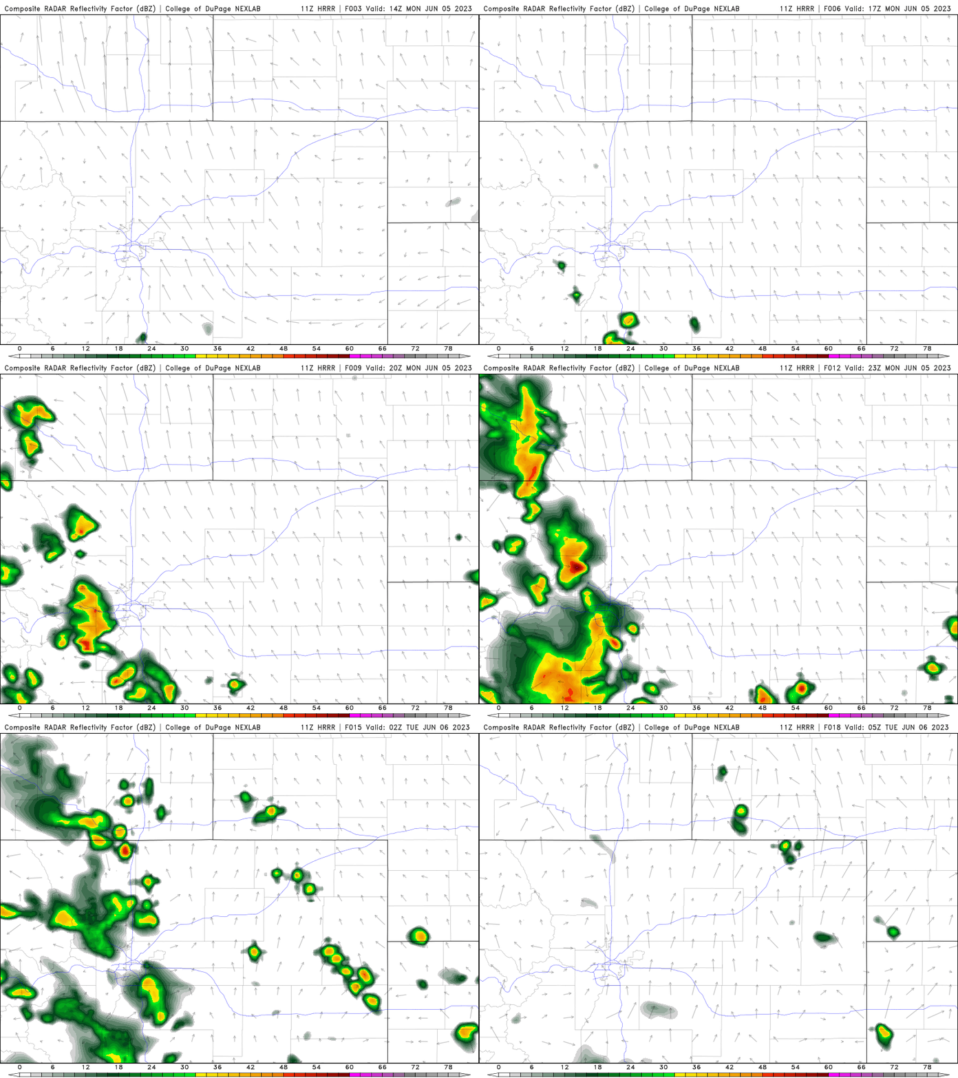
Monday and Tuesday will see storms focus more closely to the higher terrain, only spreading eastward into the Metro area during the late-afternoon and evening.
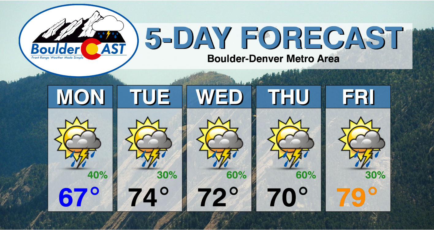
Here’s how the HRRR model evolves things on Monday: slow-moving storms develop over the Foothills by early afternoon — capitalizing on a little bit of welcomed sunshine. The storms then spread eastward into the adjacent Plains from 3 to 7PM, mainly dying out before crossing Interstate 25 into a more stable environment. A similar outcome will unfold on Tuesday. Both days should see high temperatures cooler than normal in the upper 60s to middle 70s.
Wednesday and Thursday will see an enhanced risk of thunderstorms and will be a tad cooler as a result. Instability for storms may be more limited due to the copious moisture and expected cloud cover. These days should have 50 to 70% chances for rainfall with temperatures staying cool around 70 degrees.
As mentioned earlier, Friday will be drier and warmer — still with a scattered risk of late-day storms, but with temperatures creeping up towards normal in the upper 70s.
Looking ahead to next week, this summer and NOT another Marshall Fire
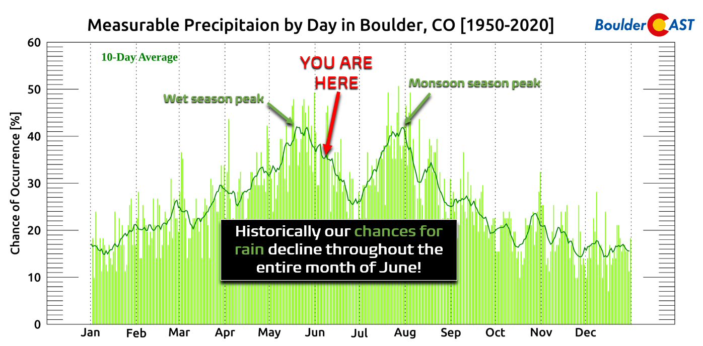
Though it is still a ways out, models generally agree that the blocking pattern across the North American continent will break down early next week leading to a less stagnant situation here in Colorado. While this initially may mean another surge of rain as a trough passes through the region, we should start to see more varied weather and likely more seasonal (i.e. warmer) temperatures take hold. We’ve really been stuck in a cool and rainy pattern of late! However, a transition towards drier weather is normal this of time year as we move into the relatively dry stretch between the spring wet season and the summer monsoon. Historically speaking, precipitation chances decline sharply throughout the entire month of June before the monsoon ramps up.
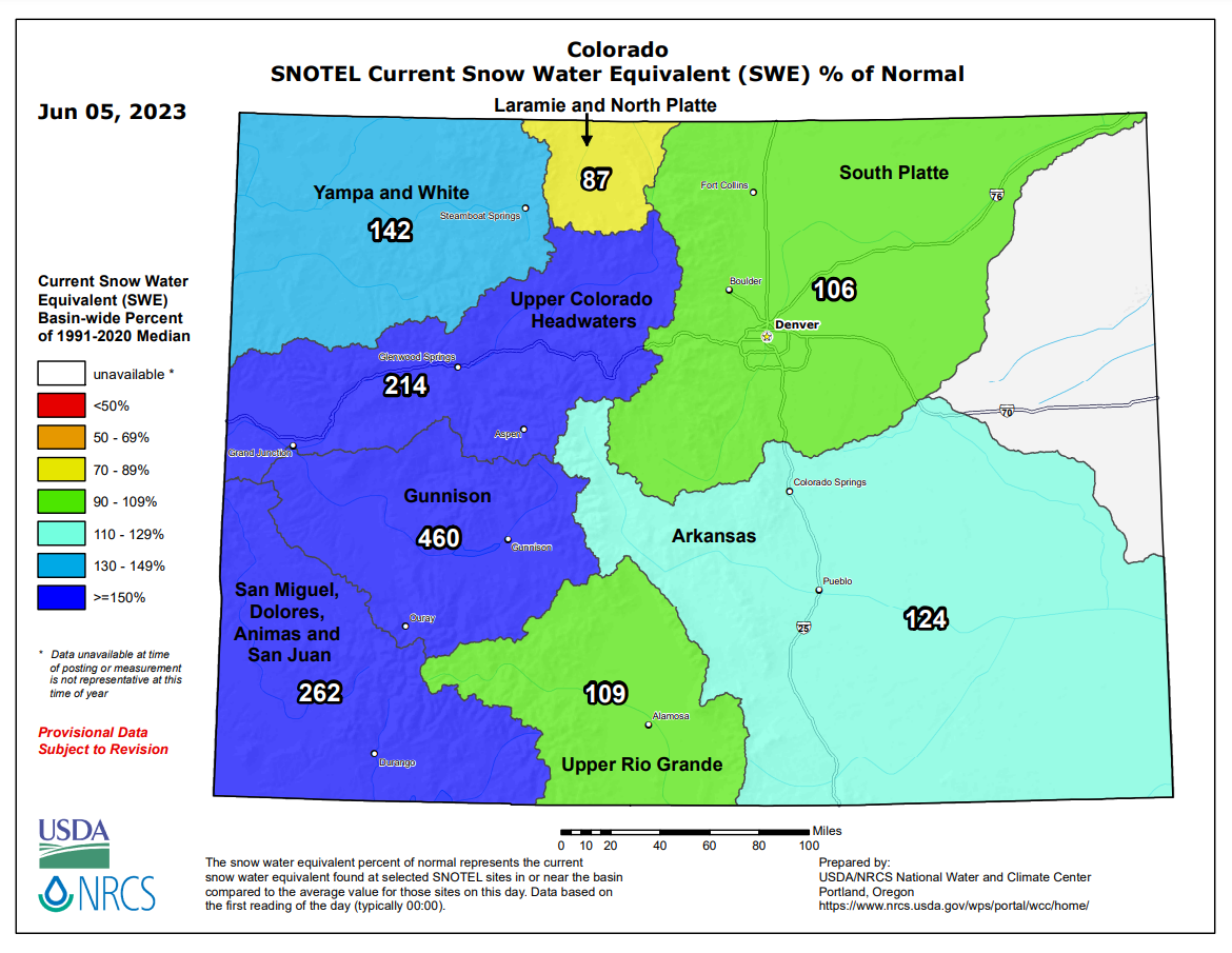
All this recent wet weather means our fire risk is exceptionally low right now — don’t let anyone tell you that’s not a good thing! We’ve seen a lot of negativity surrounding this year potentially turning into another 2021 — a year which had a record wet spring (and vegetation growth) followed by a record dry summer/autumn ultimately setting the stage for the devastating Marshall Fire in December. This year is a lot different than 2021 with La Niña already getting vaporized quickly and snowpack remaining strong across the state. We are also expecting a more pronounced monsoon pattern this summer which should help protect us from wildfires further. Wet weather isn’t always a precursor for doom and gloom here. Sometimes it’s just gloomy!
Enjoy the continued rain this week!
Forecast Specifics:
Monday: Partly cloudy skies in the morning turning mostly cloudy through the day. Scattered thunderstorms will develop over the higher terrain in the afternoon and spread eastward into the western Denver Metro area. Mainly dry east of I-25. Storms could produce localized heavy rainfall and burn scar flooding. Highs in the upper 60s to near 70 degrees on the Plains with middle 50s in the Foothills.
Tuesday: Partly cloudy skies with scattered late-day thunderstorms developing, mainly over the higher terrain and in the Denver Metro area. Storms could produce localized heavy rainfall and burn scar flooding. Highs in the lower to middle 70s on the Plains with upper 50s in the Foothills.
Wednesday: Morning sun, then rapidly increasing clouds and storms by afternoon into the evening. Storms will be numerous to widespread across the area and some could linger into Wednesday night. Some flooding possible in the burn scars and Metro area. Temperatures in the lower 70s on the Plains with upper 50s in the Foothills.
Thursday: Cooler with a mix of clouds and sunshine alongside scattered showers and thunderstorms. Highs reach near 70 degrees on the Plains with upper 50s in the Foothills.
Friday: Partly sunny with scattered late-day thunderstorms. Highs climb into the mid to upper 70s on the Plains with middle 60s in the Foothills.
DISCLAIMER: This weekly outlook forecast is created Monday morning and covers the entire upcoming week. Accuracy will decrease as the week progresses as this post is NOT updated. To receive daily updated forecasts from our team, among many other perks, subscribe to BoulderCAST Premium.
Daily Forecast Updates
Get our daily forecast discussion every morning delivered to your inbox.
All Our Model Data
Access to all our Colorado-centric high-resolution weather model graphics. Seriously — every one!
Ski & Hiking Forecasts
6-day forecasts for all the Colorado ski resorts, plus more than 120 hiking trails, including every 14er.
Smoke Forecasts
Wildfire smoke concentration predictions up to 72 hours into the future.
Exclusive Content
Weekend outlooks every Thursday, bonus storm updates, historical data and much more!
No Advertisements
Enjoy ad-free viewing on the entire site.
Get BoulderCAST updates delivered to your inbox:
Enjoy our content? Give it a share!





Thank you!!