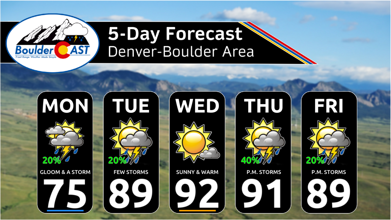
Monsoon season kicks off right on time this week, bringing a steady stream of moisture from Mexico into the Southwest and central Rockies. While daily storm chances are on tap for the Front Range, coverage looks hit-or-miss, with Wednesday shaping up to be the warmest and driest day. Expect highs ranging from the 70s to mid-90s as the pattern evolves. We also need to keep an eye on the forecast heading into Fourth of July weekend as scattered storms will be in the mix.
This week’s highlights include:
- Monsoon Moisture Begins to Return: The Southwest Monsoon is arriving right on schedule, drawing deep moisture north from Mexico into the region.
- Daily Storms: Colorado, including the Front Range, will see daily storm chances this week, though coverage will generally be spotty.
- Gloomy Start: Monday brings cool temps in the 70s and overcast skies, with only isolated showers expected.
- Dry Wednesday: Wednesday looks to be the warmest and driest day, with highs in the low to mid 90s under high pressure.
- Holiday Uncertainty: Storm chances ramp up again late week and into the Fourth of July weekend—though still some uncertainty regarding how wet the forecast will be. Stay weather-aware for holiday plans!
DISCLAIMER: This weekly outlook forecast is created Monday morning and covers the entire upcoming week. Accuracy will decrease as the week progresses as this post is NOT updated. To receive daily updated forecasts from our team, among many other perks, subscribe to BoulderCAST Premium.

Go Premium, get all the perks.
Daily Forecast Updates
Get our daily forecast discussion every morning delivered to your inbox.
All Our Model Data
Access to all our Colorado-centric high-resolution weather model graphics. Seriously — every one!
Ski & Hiking Forecasts
6-day forecasts for all the Colorado ski resorts, plus more than 120 hiking trails, including every 14er.
Smoke Forecasts
Wildfire smoke concentration predictions up to 72 hours into the future.
Exclusive Content
Weekend outlooks every Thursday, bonus storm updates, historical data and much more!
No Advertisements
Enjoy ad-free viewing on the entire site.
Right on cue: First signs of monsoon moisture
The big weather story this week is the timely return of the American Southwest Monsoon, showing up right on schedule as we head into the first week of July. Our mid-level atmospheric pattern is setting the stage with a slow-moving trough parked near California and a fairly stubborn ridge hovering over the south-central U.S. If you check out the 500mb height anomaly forecast below, you’ll see this general setup stretching from Monday through Saturday.
These two features are working in tandem to pull deep subtropical moisture up from Mexico. That surge in precipitable water will be especially noticeable across New Mexico and West Texas—and yes, much of Colorado will get in on some action too.
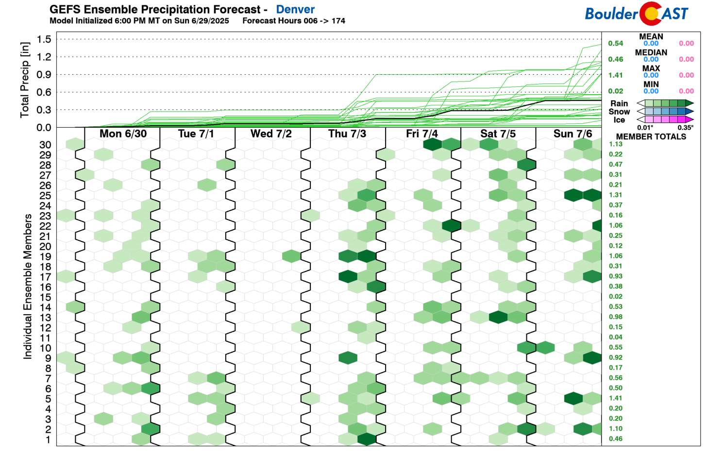
With all that moisture streaming in, we’re looking at daily storm chances across the Front Range this week. That said, overall storm coverage doesn’t look especially impressive on any given day. Monday and Tuesday bring widely scattered storms, while Wednesday might actually be the driest day of the week thanks to a brief uptick in high pressure. Storm chances are likely to pick back up Thursday and into the Fourth of July weekend.
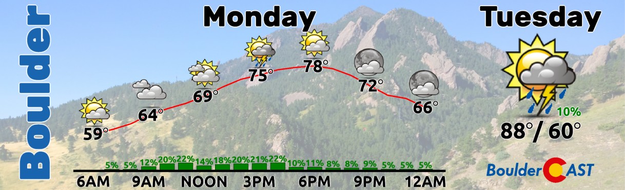
We’re starting the week under thick cloud cover, a holdover from Sunday’s cold front and the moisture that’s piling up against the terrain. Boulder Valley’s got a dreary look this morning, and while a few showers or weak storms could pop up later, most of us will stay dry with only about a 20% chance of rain, with that being mostly southwest of Denver.

View of gloomy Boulder Monday morning
Expect very comfortable highs in the 70s—though it may take most of the day to get there due to those pesky clouds.
Temps will climb into the upper 80s Tuesday, and we’ll see scattered storms develop late in the day.
Wednesday looks to be our hottest and driest day, with a ridge of high pressure moving directly overhead. Even though moisture levels remain above average, that strong ridge should suppress most storm development along the Front Range. Highs will soar into the low to mid 90s.
Thursday and Friday bring a shift in the ridge toward the east, allowing monsoon moisture to push deeper into our region. There’s still some uncertainty in the forecast models about storm coverage, but generally, we’re expecting scattered afternoon and evening storms both days. As for the Fourth of July and related activities, it’s a bit too early to call. Some rain will likely be around, but how much is yet to be determined. Stay tuned for updates through the week.
Forecast Specifics:
Monday: Gloomy and chilly with just a slight chance of a shower or weak storm, mainly southwest of Denver over the higher terrain. Highs in the middle 70s on the Plains with middle 60s in the Foothills.
Tuesday: Partly cloudy and warmer with widely scattered late-day storms. Highs jump up into the upper 80s on the Plains with middle 70s in the Foothills.
Wednesday: Mostly sunny, dry and hot with highs in the low to middle 90s on the Plains and near 80 in the Foothills.
Thursday: Morning sun, then partly cloudy with scattered late-day thunderstorms. Highs in the lower 90s on the Plains with upper 70s in the Foothills.
Friday (Independence Day): Continued chances for late-day storms with temperatures topping out around 90 degrees on the Plains and upper 70s in the Foothills.
Weekend: Temperatures stay in the 85 to 90 degree range with continued chances for late-day storms. Exact coverage remains uncertain, but most likely chances will be 20-30% over the weekend.
DISCLAIMER: This weekly outlook forecast is created Monday morning and covers the entire upcoming week. Accuracy will decrease as the week progresses as this post is NOT updated. To receive daily updated forecasts from our team, among many other perks, subscribe to BoulderCAST Premium.
Go Premium, get all the perks.
Daily Forecast Updates
Get our daily forecast discussion every morning delivered to your inbox.
All Our Model Data
Access to all our Colorado-centric high-resolution weather model graphics. Seriously — every one!
Ski & Hiking Forecasts
6-day forecasts for all the Colorado ski resorts, plus more than 120 hiking trails, including every 14er.
Smoke Forecasts
Wildfire smoke concentration predictions up to 72 hours into the future.
Exclusive Content
Weekend outlooks every Thursday, bonus storm updates, historical data and much more!
No Advertisements
Enjoy ad-free viewing on the entire site.
Enjoy our content? Give it a share!


You must be logged in to post a comment.