This week in the Front Range will feature a rollercoaster ride of temperatures from 90s to the 70s and back again! There will also be increasing rainfall chances for the mid to late-week period as remnant moisture arrives from a tropical system in the Gulf of Mexico — this is not the beginning of our seasonal monsoon just yet. Temperatures will slowly ramp up back into the 90s for the upcoming weekend. Read on for more details.
This week’s highlights include:
- Hot for one more day: It will remain hot and dry to start the week with near-critical fire conditions on Monday
- Relief on the way Tuesday: A strong cold front drops our highs way down into the upper 70s Tuesday and into the lower 70s by Wednesday
- Rain chances ramp up late week, but it’s not the monsoon yet: Rain chances will trend up Tuesday onward, but especially later in the week as a surge of moisture arrives from a remnant tropical wave in the Gulf of Mexico
- Return of the heat: Seasonally warm weather returns late-week with a push back towards 90 degrees, with even hotter temperatures expected for the upcoming weekend
DISCLAIMER: This weekly outlook forecast is created Monday morning and covers the entire upcoming week. Accuracy will decrease as the week progresses as this post is NOT updated. To receive daily updated forecasts from our team, among many other perks, subscribe to BoulderCAST Premium.

Go Premium, get all the perks.
Daily Forecast Updates
Get our daily forecast discussion every morning delivered to your inbox.
All Our Model Data
Access to all our Colorado-centric high-resolution weather model graphics. Seriously — every one!
Ski & Hiking Forecasts
6-day forecasts for all the Colorado ski resorts, plus more than 120 hiking trails, including every 14er.
Smoke Forecasts
Wildfire smoke concentration predictions up to 72 hours into the future.
Exclusive Content
Weekend outlooks every Thursday, bonus storm updates, historical data and much more!
No Advertisements
Enjoy ad-free viewing on the entire site.
Hot and dry to start
Hot and dry weather will continue to start the work week as broad southwest flow persists across the region, as shown below. One change for our Monday will be an increase in low-level winds, favoring gusts up to 30 MPH during the afternoon hours on the Plains. Highs temperatures are likely to top out in the middle 90s with no threat of rain. The closest area with rain will be up across western Nebraska and Wyoming.
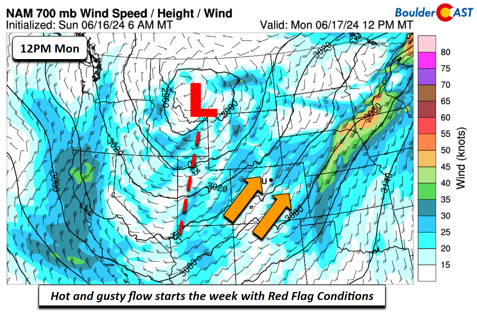
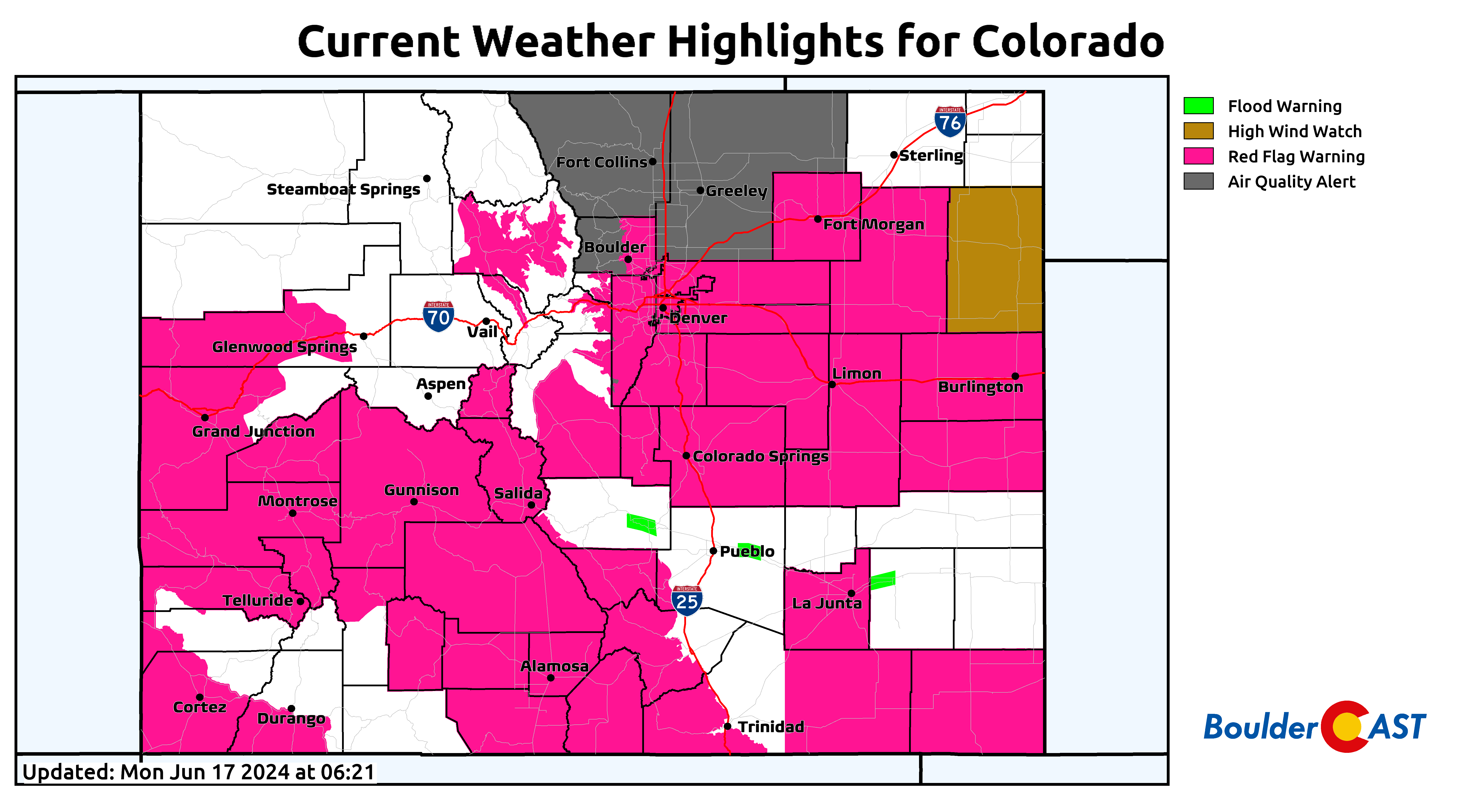
Critical fire weather conditions will be in place on Monday, resulting from the combination of low relative humidity (below), hot temperatures, and the aforementioned gusty winds.
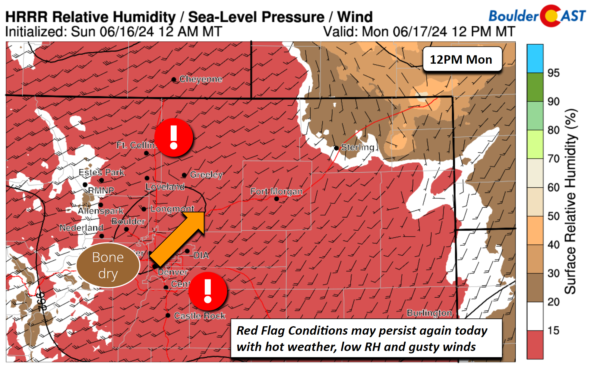
Red Flag Warnings are posted for a large chunk of the Centennial State on Monday, including Boulder and Denver. Hopefully we can get through the day without any fire ignitions across the state…
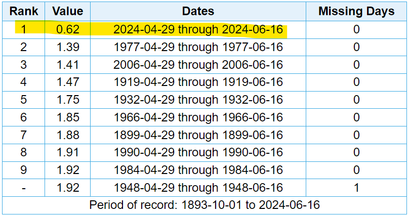
The fire situation right now is growing more dangerous. We had a very wet early spring, but dry conditions have taken over since late April with well below normal precipitation for our area since then. This dry period has been magnified in some areas, including Boulder which continues to build upon its all-time driest late-spring period on record. Just 0.62″ of rain has fallen since late April, less than half the prior record low rainfall amount for this period and less than 15% of normal for this usually wet time. While it’s undeniably still early in the year, our current situation bears early resemblance to 2021 — that is, an historically wet spring with bountiful fuel growth (grass) followed by a record-setting dry summer and autumn leading up to the Marshall Fire.
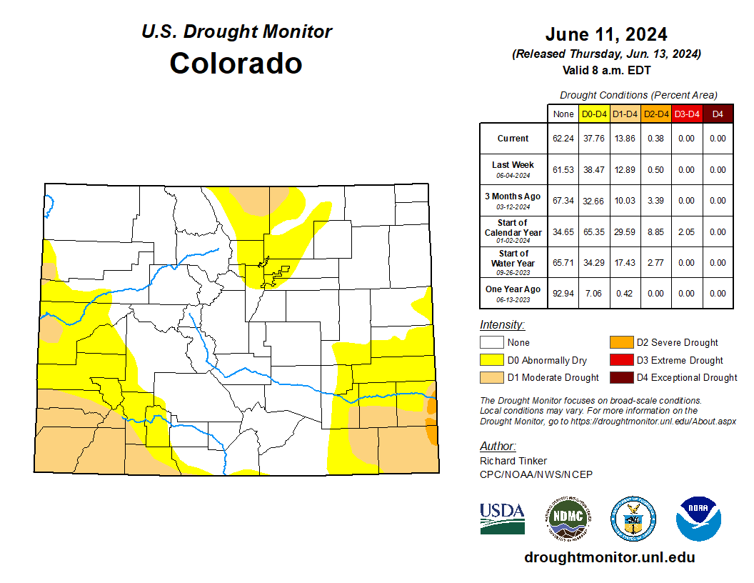
This recent dry stretch has seeded the return of drought to Front Range Colorado, with currently parts of Larimer and Weld Counties included (tan color below). If we don’t receive widespread and significant rainfall soon, both Boulder and Denver will be following suit.
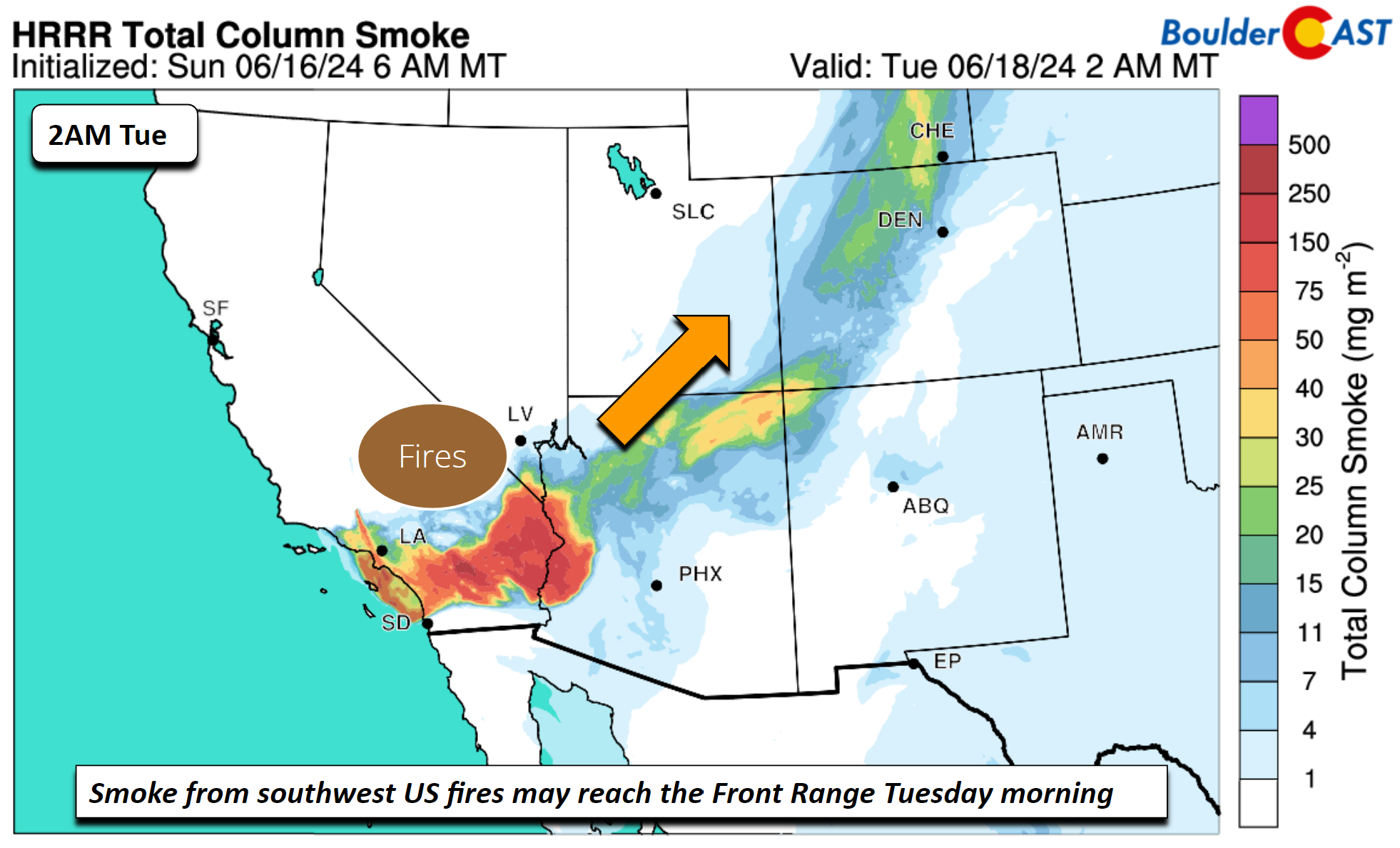
Back to the weather at hand, though. The broad southwest flow early this week could advect in periods wildfire smoke, mainly from the 15,000-acre Post Fire burning north of Los Angeles. The latest smoke forecast shows a wave of lofted smoke moving in Monday night and into our Tuesday, which could cause some reduction in visibility, though the surface-based smoke is rather limited (no major impact on PM2.5 air quality).
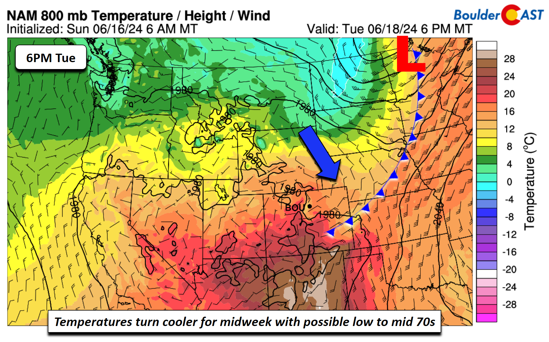
We have been talking about it all weekend, but a cold front will move through Monday night, ushering in a welcomed cooler airmass. Highs Tuesday will be some 15 to 20 degrees cooler in the upper 70s to lower 80s, depending where you are on the Front Range. Unfortunately, the front will also trigger some low-end rain chances late in the afternoon/evening with the upslope flow. Instability is rather weak, such that we anticipate only a 10% chance.
Rain chances rise mid to late week, but it’s not the monsoon yet
As we go through the mid to latter part of the week, rain chances will ramp up, especially Wednesday into Friday. As shown below, a favorable setup will develop. That is, a strong ridge bringing impressive record heat across the East and an area of low pressure near California to our west. The combination of these two features will provide a broad south-southwest flow into Colorado, aiding moisture transport from the Pacific Ocean.
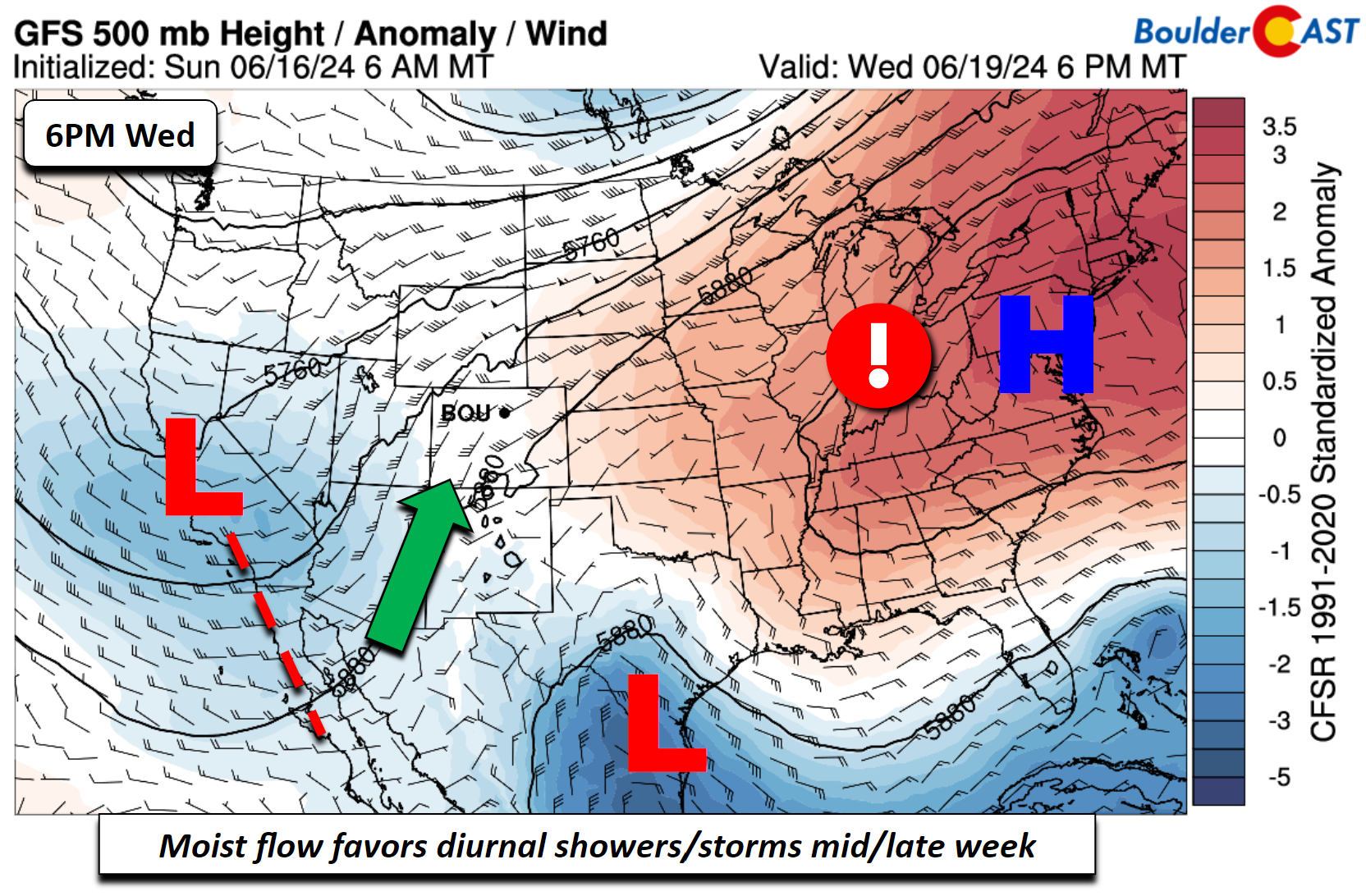
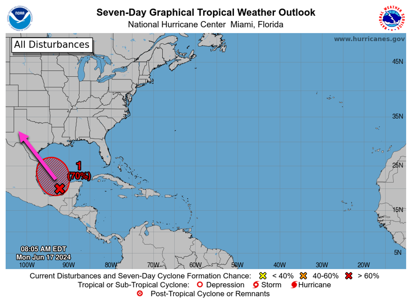
Additionally, a disturbance developing in the Gulf of Mexico right now is favored to become the Atlantic Basin’s first named storm of the season in the next day or two. After making landfall in south Texas, this tropical remnant should bring additional moisture into our region Thursday or Friday — fuel for our late-day storms.
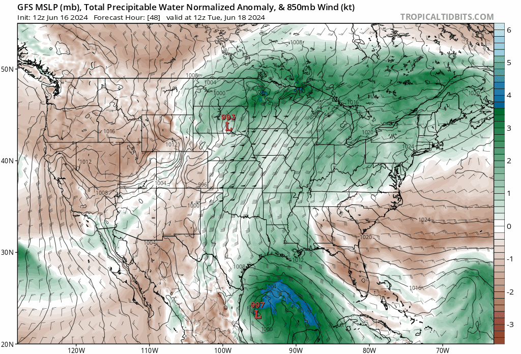
The animation below shows forecast precipitable water anomalies from Tuesday through Friday displaying an uptick in anomalous moisture later this week. Note in particular the additional surge of moisture that comes from whatever evolves out of the Gulf of Mexico disturbance. This setup will certainly be something to watch. Our rain chances will likely be in the 30-50% chance range during the latter part of the week. As for temperatures, chilly highs in the lower 70s midweek should trend upward back close to 90 by week’s end as the cool airmass erodes and lifts out.
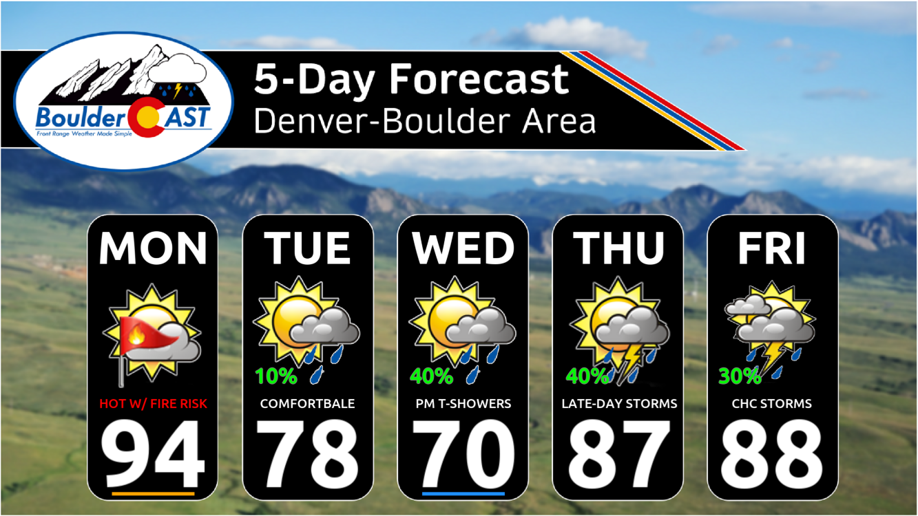
Here’s a look at our extended forecast this week with temperatures unfolding a bit like a rollercoaster ride! Hopefully we can wring out much-needed rainfall later this week from the surge in tropical moisture!
And no, the late-week uptick in rainfall chances is NOT the beginning of monsoon season yet. That would require a longer duration, persistent shift in the large-scale weather pattern across North America. Monsoon season will come in due time, typically arriving the first week or two of July here in the Front Range.
The weekend ahead will see rainfall chances trend down as temperatures push back into the 90s. It won’t be completely dry, but late-day storms will be more widely scattered.
Enjoy the wonderful weather this week!
Get BoulderCAST updates delivered to your inbox:
Forecast Specifics:
Monday: Hot and dry with near-critical fire conditions. Highs in the low to mid 90s for the Plains and low to mid 80s in the Foothills.
Tuesday: Increasing clouds with late-day isolated thundershowers possible. Highs much cooler in the upper 70s to near 80 degrees.
Wednesday: Partly to mostly cloudy with a 40% chance of showers/storms in the afternoon/evening. Highs in the low to mid 70s for the Plains and lower to mid 60s in the Foothills.
Thursday and Friday: Partly to mostly cloudy with a 30-40% chance of afternoon/evening storms. Highs in the mid/upper 80s for the Plains with middle 70s in the Foothills.
DISCLAIMER: This weekly outlook forecast is created Monday morning and covers the entire upcoming week. Accuracy will decrease as the week progresses as this post is NOT updated. To receive daily updated forecasts from our team, among many other perks, subscribe to BoulderCAST Premium.
Go Premium, get all the perks.
Daily Forecast Updates
Get our daily forecast discussion every morning delivered to your inbox.
All Our Model Data
Access to all our Colorado-centric high-resolution weather model graphics. Seriously — every one!
Ski & Hiking Forecasts
6-day forecasts for all the Colorado ski resorts, plus more than 120 hiking trails, including every 14er.
Smoke Forecasts
Wildfire smoke concentration predictions up to 72 hours into the future.
Exclusive Content
Weekend outlooks every Thursday, bonus storm updates, historical data and much more!
No Advertisements
Enjoy ad-free viewing on the entire site.
Enjoy our content? Give it a share!


Thanks for noting the extended dryness. Fingers crossed this week’s storms provide some rain!
Fingers and toes, please 🙂