Say goodbye to those 70s we had on Sunday. Record-setting heat is queuing up later this week as a strong ridge will build into the area from the Desert Southwest. With this, expect progressively warmer daytime highs as the week wears on, eventually soaring into the lower 100s by Friday and into the weekend ahead. Alongside the heat, there will be very limited chances for rain this week, with any storms that do manage to form in this hot and dry airmass being mainly confined to the Mountains and Foothills.
This week’s highlights include:
- Anomalous ridging: Anomalous ridging over the central Great Basin will keep us largely dry and trending hot by late-week as the ridge moves directly over Colorado
- Multiple days of triple digit heat are looming: Highs will gradually rise throughout the week, from the lower 80s into the lower 100s by week’s end. Record highs, perhaps several days in a row, are expected Friday into early next week
- Limited rain potential: Rain chances at about 10% or less, with storms mainly confined to the Foothills and Mountains this week
- Tropics: Watching Hurricane Beryl as the storm moves inland into the U.S. Monday with heavy rain, strong winds, and tornadoes
DISCLAIMER: This weekly outlook forecast is created Monday morning and covers the entire upcoming week. Accuracy will decrease as the week progresses as this post is NOT updated. To receive daily updated forecasts from our team, among many other perks, subscribe to BoulderCAST Premium.

Go Premium, get all the perks.
Daily Forecast Updates
Get our daily forecast discussion every morning delivered to your inbox.
All Our Model Data
Access to all our Colorado-centric high-resolution weather model graphics. Seriously — every one!
Ski & Hiking Forecasts
6-day forecasts for all the Colorado ski resorts, plus more than 120 hiking trails, including every 14er.
Smoke Forecasts
Wildfire smoke concentration predictions up to 72 hours into the future.
Exclusive Content
Weekend outlooks every Thursday, bonus storm updates, historical data and much more!
No Advertisements
Enjoy ad-free viewing on the entire site.
Hot weather builds back in slowly alongside limited rainfall chances
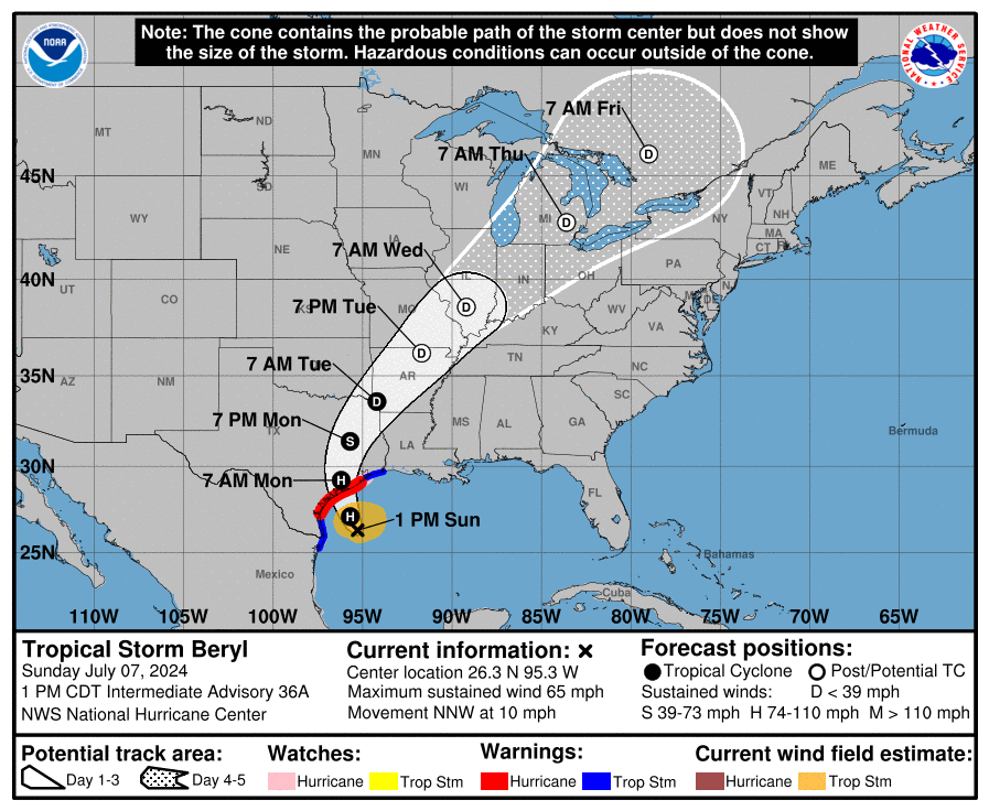
Before we get into this week’s weather, let’s quickly discuss the tropics. Hurricane Beryl has now made its fourth (fifth?) landfall early Monday morning across southeastern Texas with heavy rain and sustained winds up to 80 MPH. The eye of the hurricane is located just southwest of Houston, as seen in the current radar animation below. The immediate Houston area is expected to receive between 5 and 10 inches of rainfall on Monday along with a few tornadoes — which are commonplace in the northeast quadrant of Northern Hemisphere hurricanes.
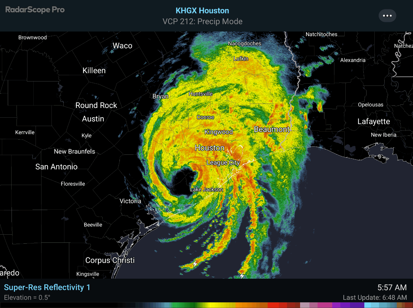
Beryl will not impact Colorado by any means, but after it moves inland, models show it taking a north-northeast track into the Midwest and Great Lakes. The rest of the tropics look quiet as of now with no sign of additional tropical storms forming in the coming days.
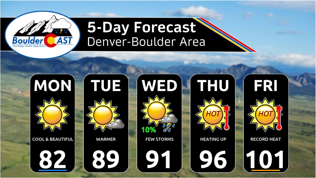
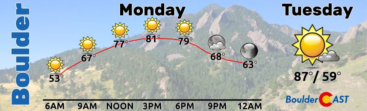
Alright, back to Colorado weather! Monday will be our last day of below normal high temperatures. This past weekend’s cold front is moving away and the trough axis lies just to our east in Kansas.
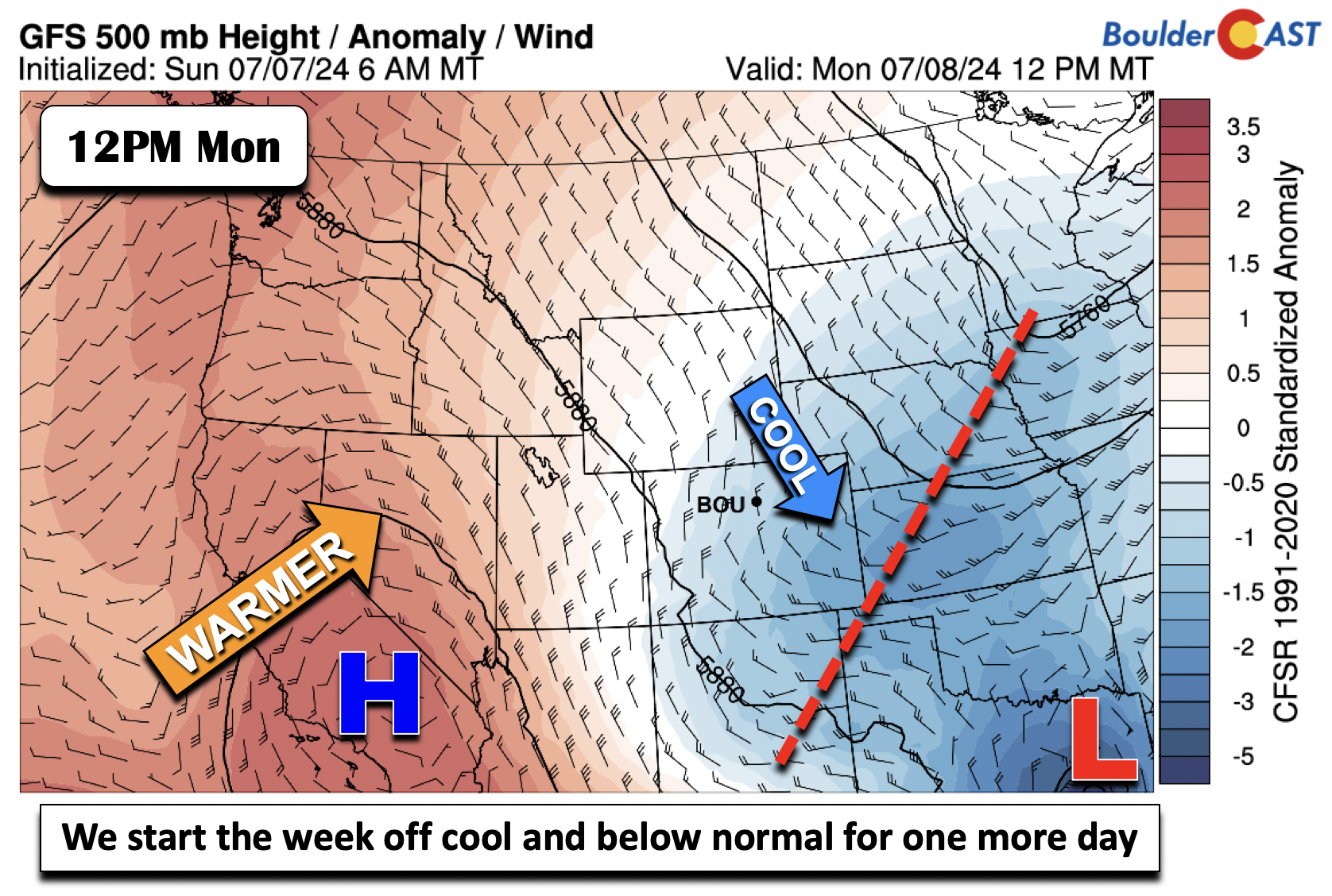
We will still be on the cool side nonetheless with mostly lower 80s in the Denver Metro area Monday. There is little chance of rain today and all week, as we’ll discuss a bit later, but the High Country will certainly see those isolated storms during peak heating.
The cold front will be in a similar position today to the trough, over central to eastern Kansas. We will still be in that cool airmass so take advantage of Monday’s cooler weather while you can — significant heat is on the way!
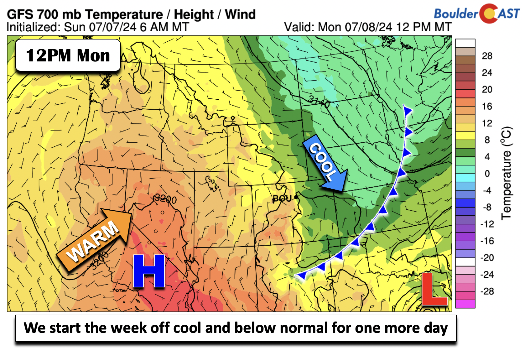
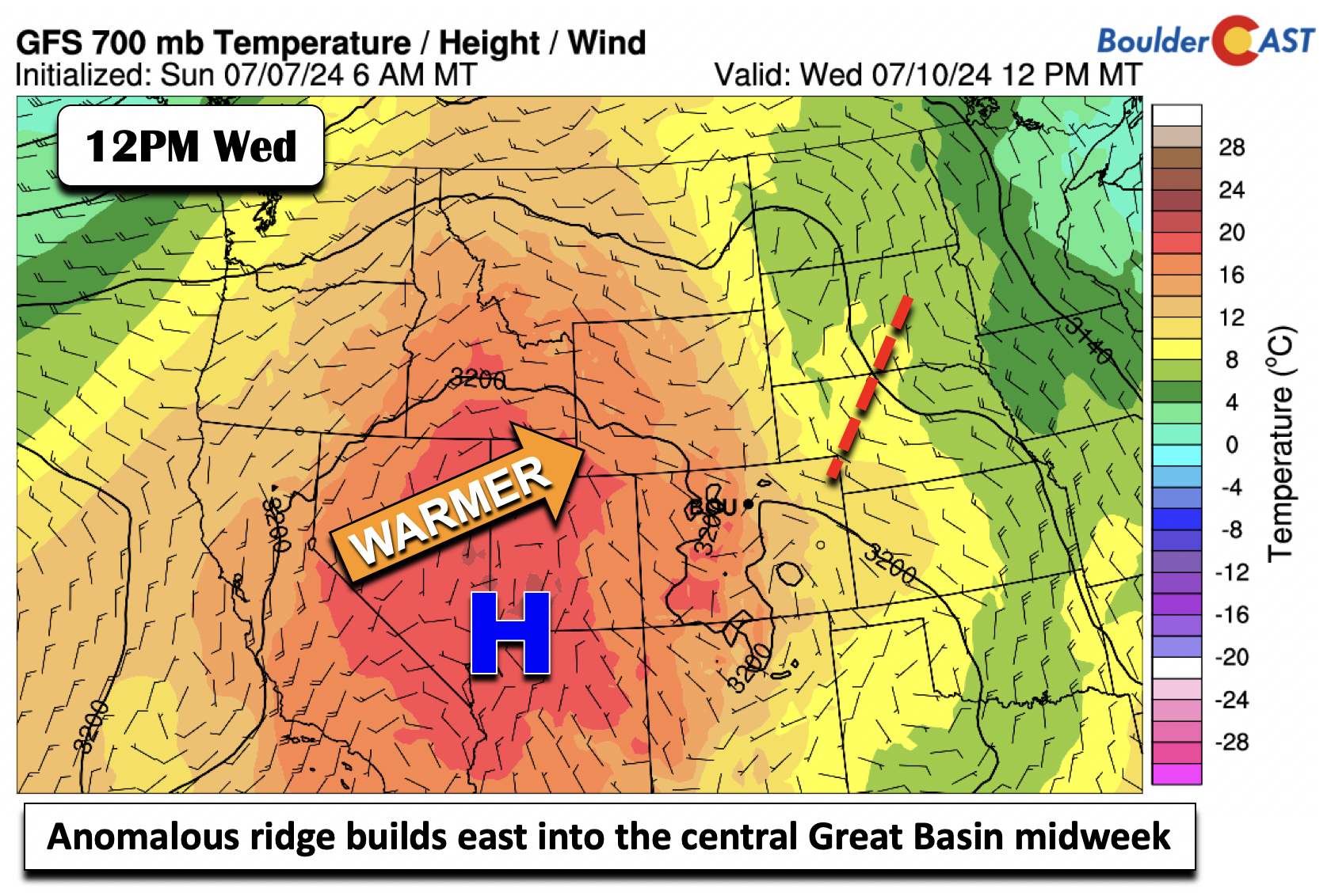
Come midweek, the ridge of high pressure over far southern California is forecast to reach the central Great Plains. The trough axis to our east on Monday will be further displaced over the Midwest.
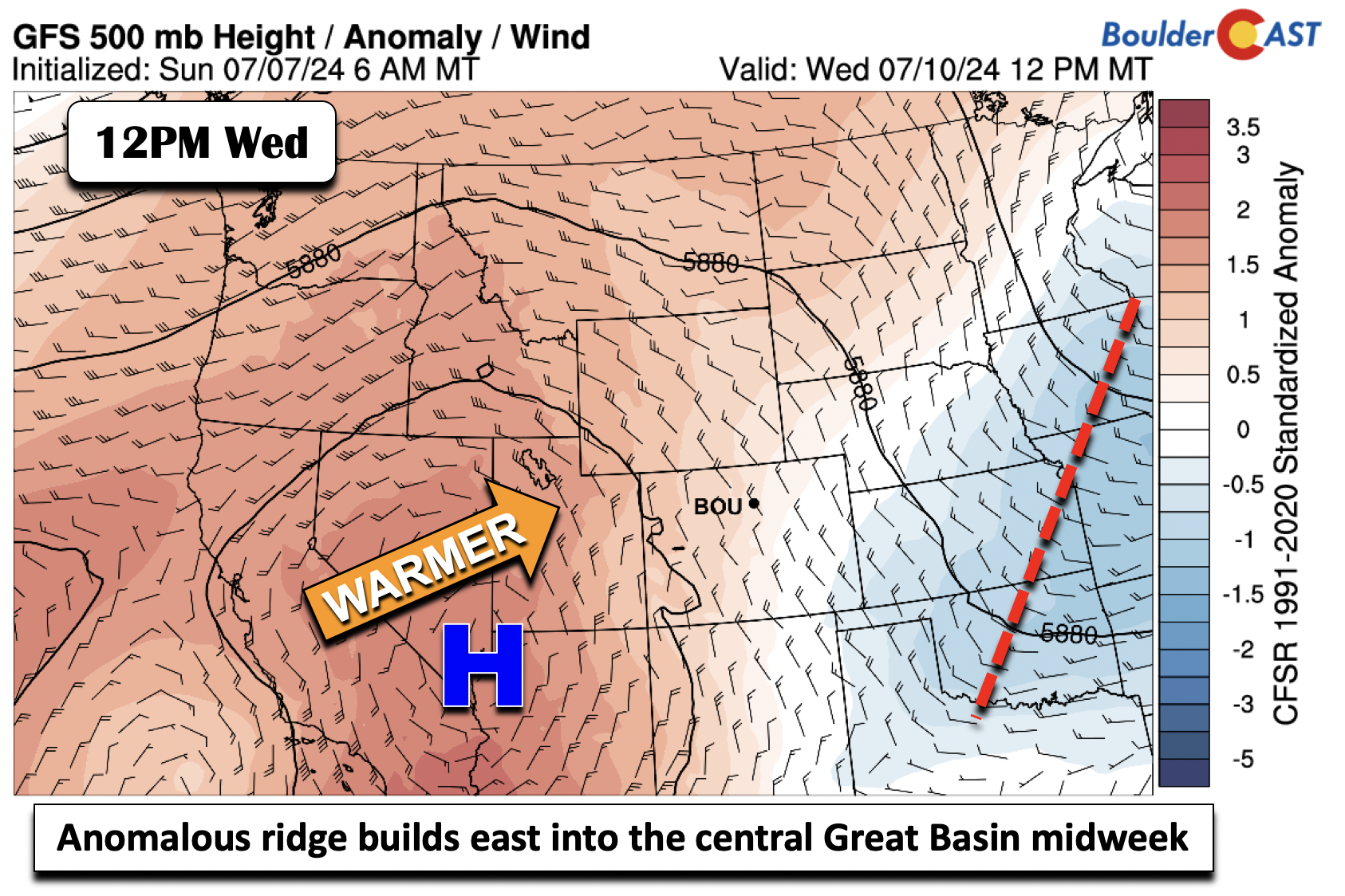
This will favor rising low-level temperatures via a warming airmass. Highs Tuesday and Wednesday should range from the upper 80s to lower 90s. There will be some very low-end rain chances, but they will be hard to come by. The Foothills and Mountains will again see the best chance with isolated to widely scattered late-day storms Tuesday through Thursday. It’s conceivable that one or two weak showers or storms may spread off the higher terrain into the Boulder area, but any of these showers would be more wind than rain.
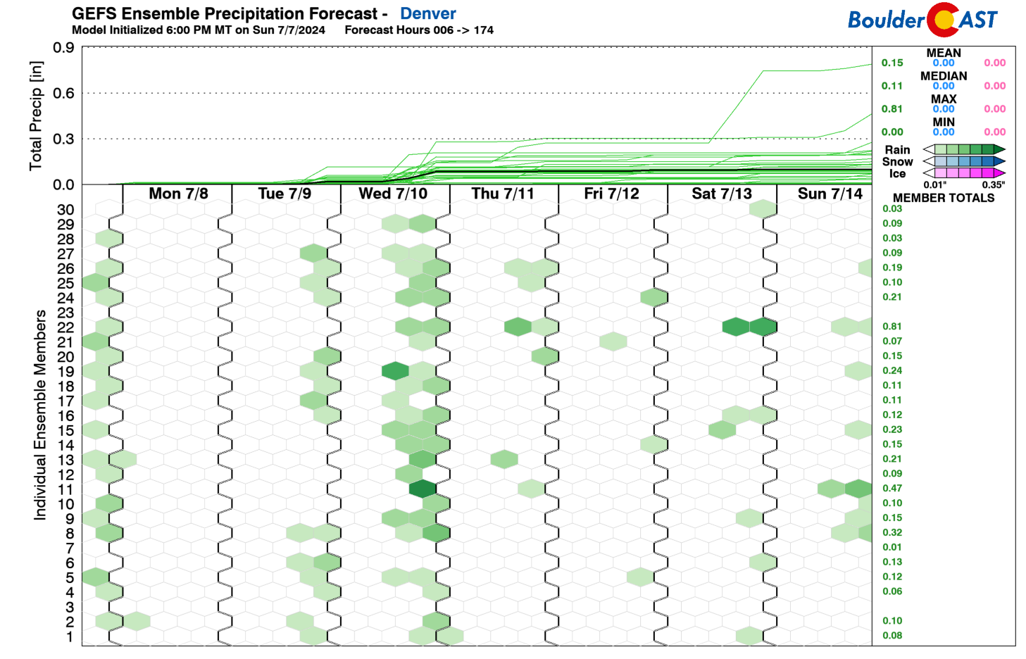
Speaking of that rain chance, below shows the GEFS precipitation outlook through the week and weekend. A select few of members show rain chances Tuesday and Wednesday, but the pattern is not very supportive, as we indicated just above. It would appear these chances may be tied to weak upslope flow and a few subtle surface boundaries. Nonetheless, these rain chances Tuesday and Wednesday will be 10% or less, at best. Even lower rain chances are expected for the tail-end of the week and upcoming weekend. We’ll discuss why that is in a bit.
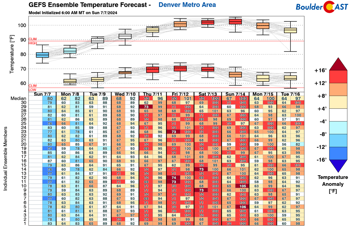
On a similar note as the previous figure, the image below shows the ensemble temperature forecast from the GFS for the Metro area. Note the steady rise in high temperatures each successive day. By the time we get to Friday, high temperatures will approach record levels in the lower 100s. The record high temperature in Boulder on Friday is 103°F — we’ll be in that ballpark but likely will come up short.
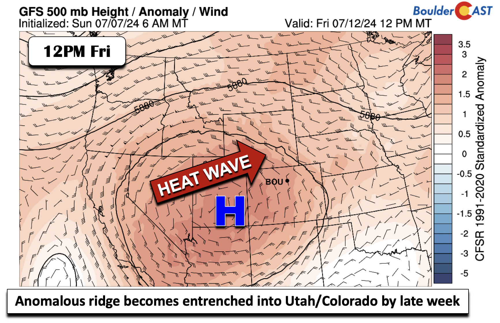
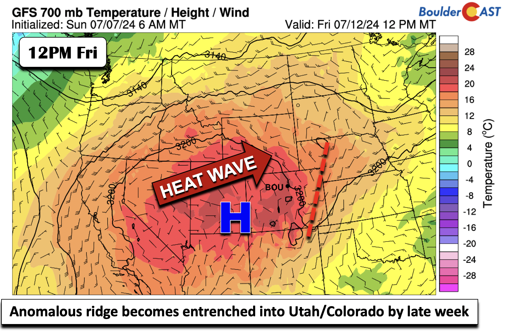
Those rising temperatures are due to the aforementioned potent ridge building into Utah and Colorado by the end of the week. Note its location midday Friday in the figure below — with 500mb height close to 6000 meters in parts of Colorado. This pattern is not at all conducive to monsoon moisture given the northerly mid-level flow. Any moisture with the monsoon would be shunted to our south and west — further supporting our recent post discussing how this year’s monsoon will tragically underperform.
Low-level temperatures by Friday may approach 20°C, easily supporting our temperatures spiking close to 100 degrees. In fact, our current forecast high for Friday is 101°F!
Here’s a look at the forecast for the week. As promised, temperatures will be trending up each day with our best (but still a tiny) chance of raindrops coming late-day Wednesday. The oven really heats up by the end of the week! One positive side effect of the big ridge being directly over Colorado will be lighter winds. This will allow for lessened fire danger in the extended, despite extremely dry fuels regionwide.
Temperatures during the upcoming weekend will be very similar to Friday, if unfortunately not a degree or two warmer. Almost every Front Range city is expected the eclipse 100 degrees this weekend, if not several days in a row. The only new record high that we are predicting in Boulder is on Sunday which has a more attainable 99°F existing record.
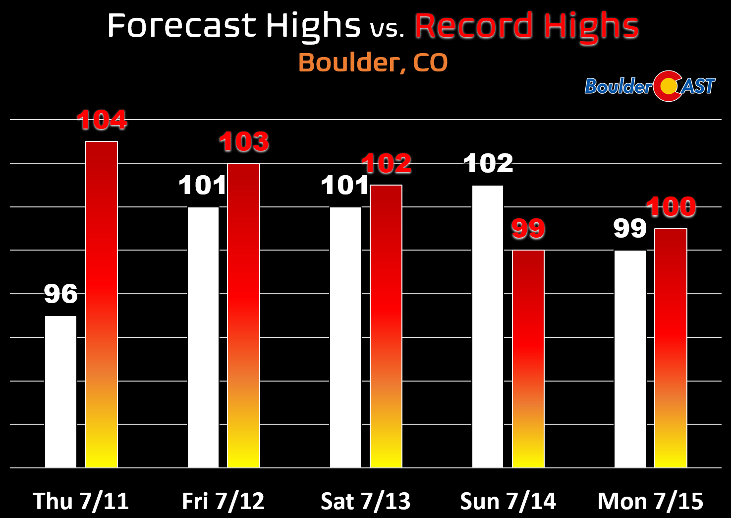
Regardless of exactly how hot we get during the looming heatwave, these will be the hottest temperatures since July 2022 for the area. In fact, Boulder hasn’t seen a temperature above 100°F since the blistering and fiery summer of 2012 — twelve years ago. It is likely this streak will come to an end this weekend. Heat Advisories be posted in the Denver Metro area Friday through Monday at minimum — maybe even longer. Plan now for an extended period of scorching and potentially dangerous heat!

That’s all for now. Try to get outside and enjoy the cooler weather on Monday as it will unfortunately not last! Stay cool out there!
🎆 Air quality this evening before sunset and just in #Denver. Not surprisingly ots of smoke fills the air now. Breathe deep #cowx pic.twitter.com/rPb52meFUO
— BoulderCAST Weather 🏔️❄️ (@BoulderCAST) July 5, 2024
Get BoulderCAST updates delivered to your inbox:
Forecast Specifics:
Monday: Sunny and cool with highs in the lower 80s on the Plains and lower 70s in the Foothills.
Tuesday and Wednesday: Mostly sunny with a 5-10% chance or less of isolated late-day storms, mainly across the Foothills and Palmer Divide. Highs in the upper 80s to low 90s for the Plains and upper 70s to near 80 in the Foothills.
Thursday: Mostly sunny but temperature start to become uncomfortably hot. Highs will reach the middle to upper 90s on the Plains with lower 80s in the Foothills.
Friday: Very hot with temperatures pushing into the lower 100s, especially in downtown Denver. Highs over the Foothills in the mid to upper 80s. No chance of rain.
Weekend: More of the same weather is expected with very limited rain chances and temperatures close to record values in the lower 100s.
DISCLAIMER: This weekly outlook forecast is created Monday morning and covers the entire upcoming week. Accuracy will decrease as the week progresses as this post is NOT updated. To receive daily updated forecasts from our team, among many other perks, subscribe to BoulderCAST Premium.
Go Premium, get all the perks.
Daily Forecast Updates
Get our daily forecast discussion every morning delivered to your inbox.
All Our Model Data
Access to all our Colorado-centric high-resolution weather model graphics. Seriously — every one!
Ski & Hiking Forecasts
6-day forecasts for all the Colorado ski resorts, plus more than 120 hiking trails, including every 14er.
Smoke Forecasts
Wildfire smoke concentration predictions up to 72 hours into the future.
Exclusive Content
Weekend outlooks every Thursday, bonus storm updates, historical data and much more!
No Advertisements
Enjoy ad-free viewing on the entire site.
Enjoy our content? Give it a share!


Fantastic write up! So glad I subscribed, literally feel like I know what’s going on in the state for the first time in decades – thank you for your hard work!!
Thanks Jenny for the kind note. We appreciate you back!