A quick round of overnight snow is already over and done with in the area as of Monday morning, but it’s just the opening act in a busy week of weather across the Front Range. Several cold fronts are lined up to keep temperatures bouncing around, including a late‑week Arctic surge that could deliver the coldest air of the season and a chance for additional snow. Read on as we break down the timing of at least three different cold fronts, the associated wind and fire‑weather concerns, and what to expect as that Arctic air barrels in later this week.
This week’s highlights include:
- ❄️ Monday morning snow exits — Light snow wraps up by mid‑morning; slick roads linger for the commute.
- 🌤️ Sun returns quickly Monday— Clearing skies boost temps into the upper 30s to low 40s.
- 💨 Windy & warmer Tuesday — WNW gusts 20–30 MPH, lower 50s, and elevated fire danger (highest in far northern Colorado).
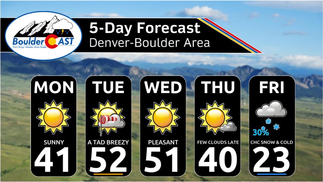
- 🌡️ Parade of fronts — Several cold fronts Tuesday–Thursday keep temps bouncing between 30s to lower 50s
- 🥶 Arctic blast late week — A strong Arctic front Thursday night/Friday could drop highs into the teens/20s, possibly colder if the air pushes farther west. Exact timing is still uncertain.
- 🌨️ Snow chances return — Light snow possible Friday–Saturday; early odds show ~30% for 1–2″ on the Front Range, higher in the Foothills/High Country.
DISCLAIMER: This weekly outlook forecast is created Monday morning and covers the entire upcoming week. Accuracy will decrease as the week progresses as this post is NOT updated. To receive daily updated forecasts from our team, among many other perks, subscribe to BoulderCAST Premium.

Go Premium, get all the perks.
Daily Forecast Updates
Get our daily forecast discussion every morning delivered to your inbox.
All Our Model Data
Access to all our Colorado-centric high-resolution weather model graphics. Seriously — every one!
Ski & Hiking Forecasts
6-day forecasts for all the Colorado ski resorts, plus more than 120 hiking trails, including every 14er.
Smoke Forecasts
Wildfire smoke concentration predictions up to 72 hours into the future.
Exclusive Content
Weekend outlooks every Thursday, bonus storm updates, historical data and much more!
No Advertisements
Enjoy ad-free viewing on the entire site.
A parade of cold fronts, culminating with a late-week Arctic blast
Sunday night’s light snow is already packing its bags and heading out, with flurries tapering off around sunrise. Snow totals of 1 to 2 inches were common overnight, with surprising totals over 3 inches in parts of the high Foothills.
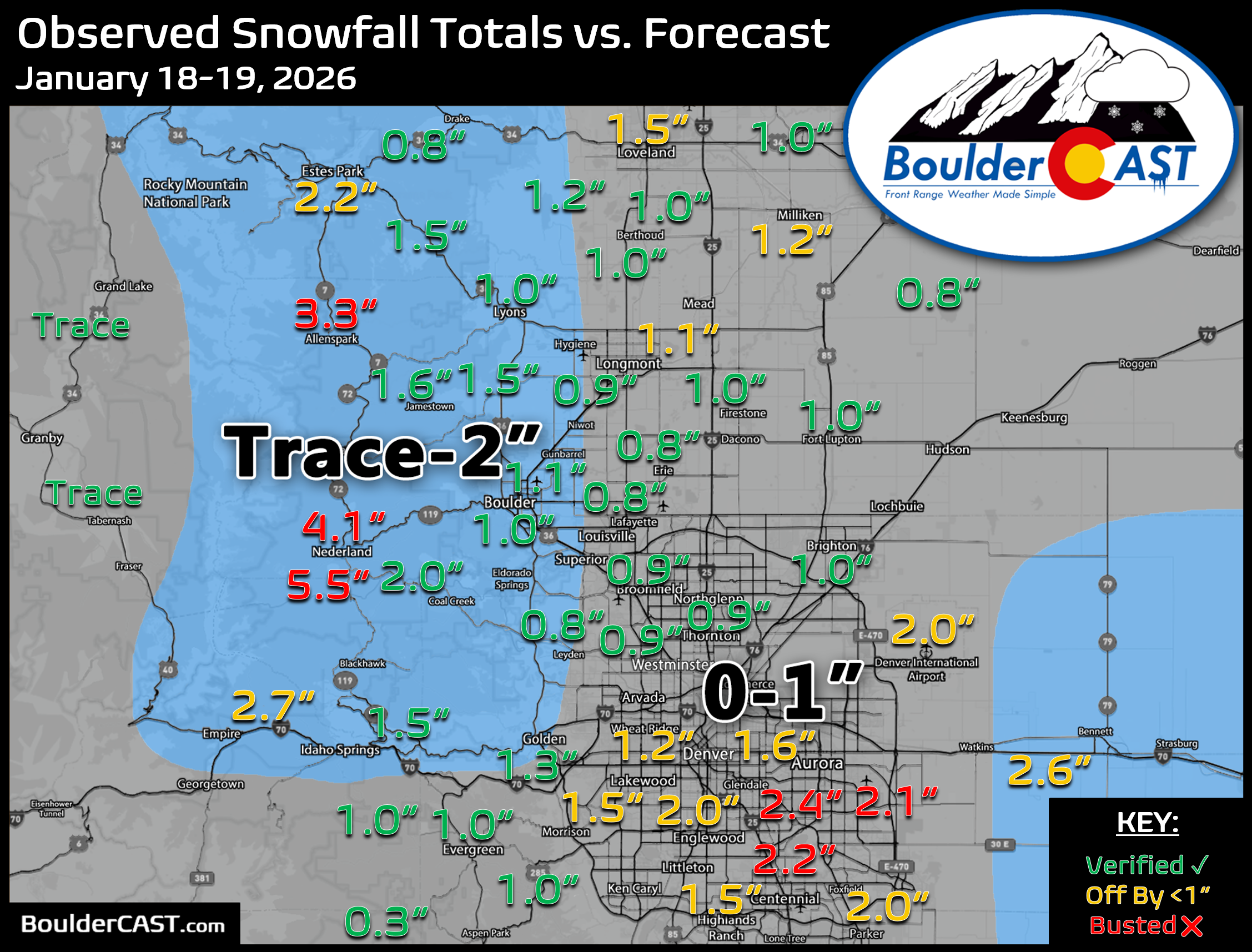
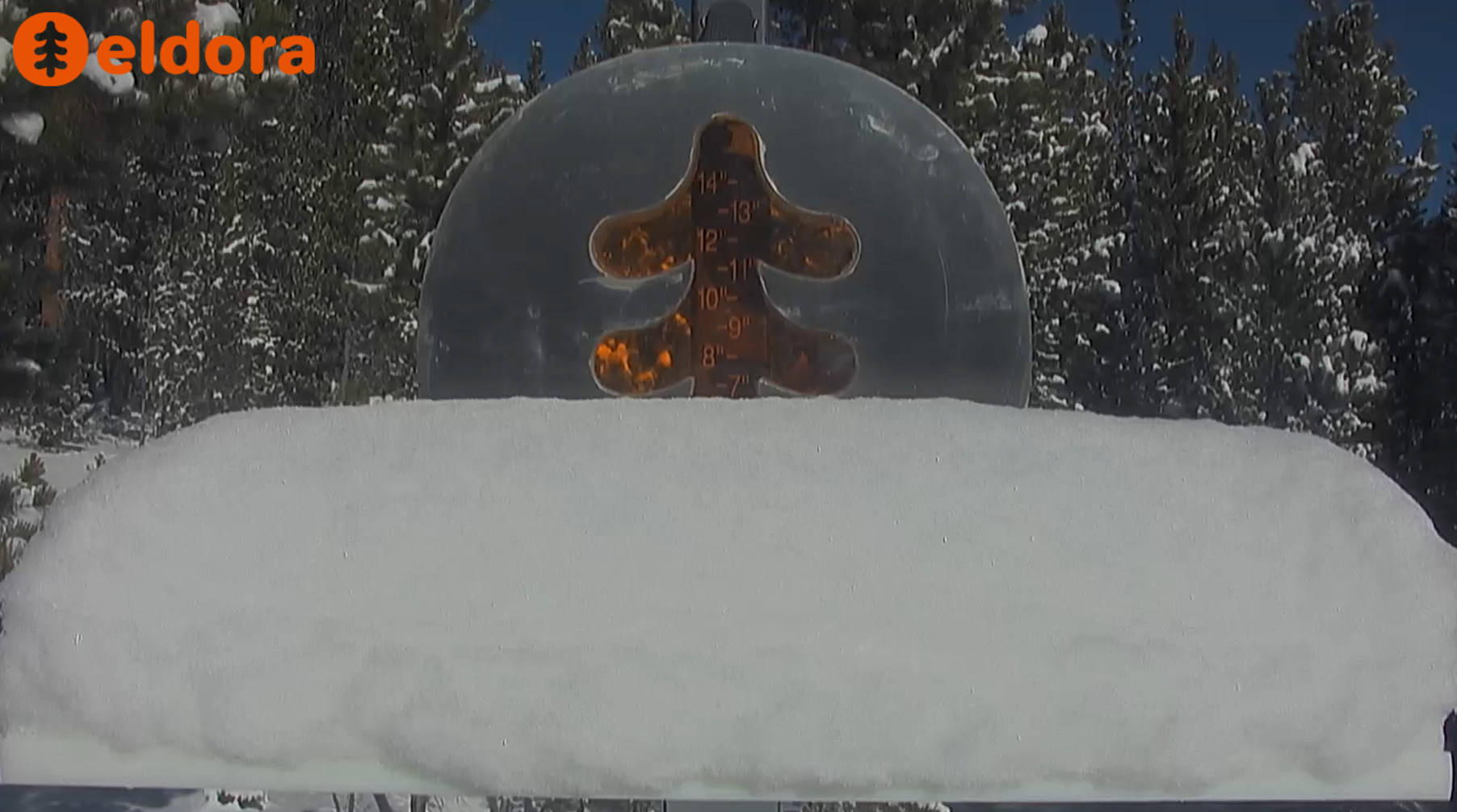
Eldora was the big winner, with 6 inches falling overnight — and yes the parking lots are already full there!
Roads across the Denver Metro are slick thanks to that widespread overnight flakes, so take it easy on your A.M. commute.

CU snow table view, Monday morning
Once the sun breaks through later this morning, we’ll warm into the the lower 40s…cool, but perfectly serviceable for a January Monday.

If last week felt like a parade of cold fronts, well…welcome to the sequel. We’ve got another series of fronts lined up for the days ahead. Before each one arrives, temperatures will bounce back to near‑normal levels in the upper 40s to lower 50s. After each one passes, we dip below average again. The real attention‑grabber is a late‑week Arctic boundary that could deliver the coldest air we’ve seen so far this season with highs potentially stuck in the teens and 20s.
Once Monday’s system exits, the atmosphere catches its breath briefly. But by Tuesday afternoon and evening, another mid‑level trough digs southeast across the northern Plains.
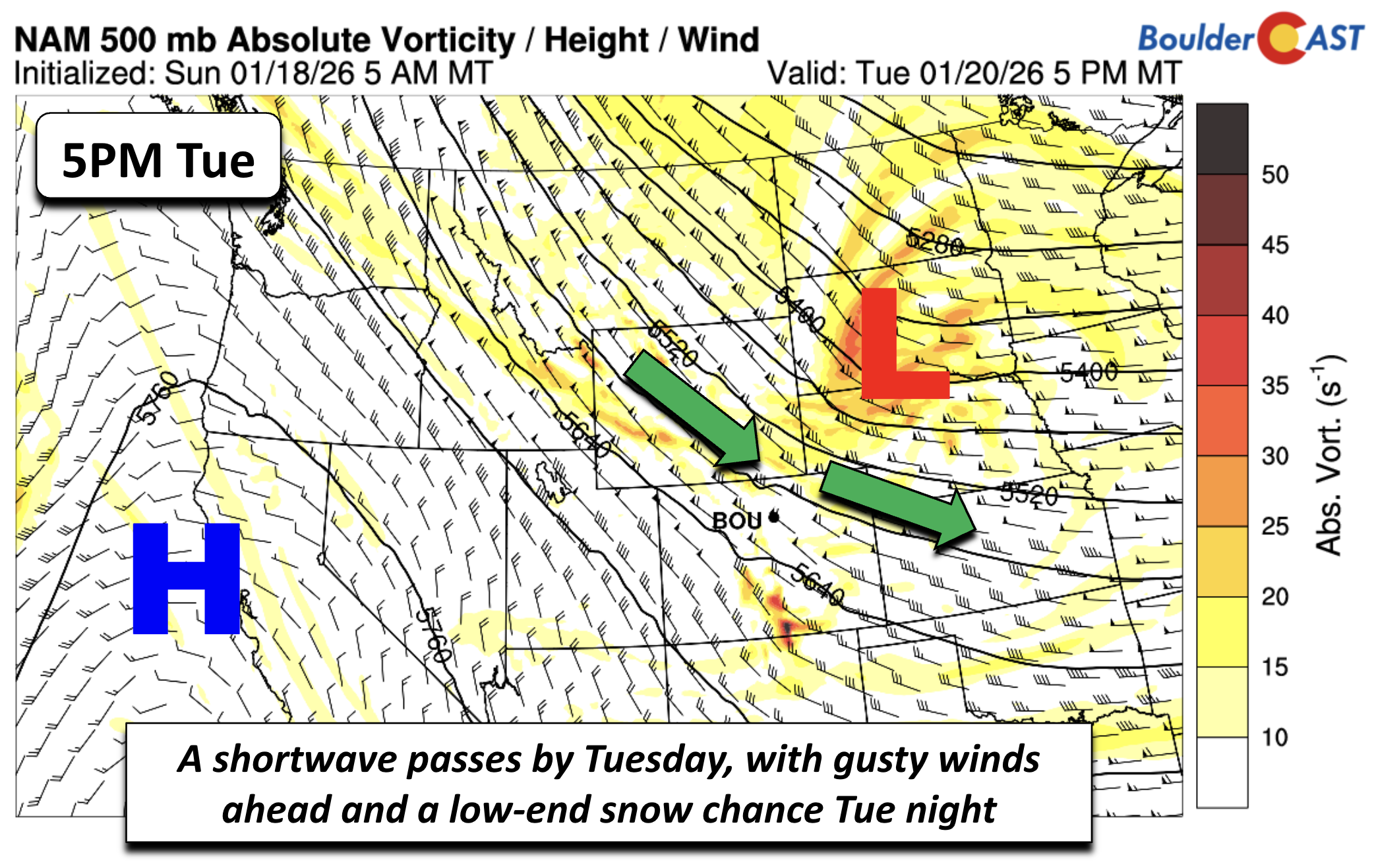
Ahead of it, expect a burst of WNW winds gusting 20–30 MPH. With low humidity and highs climbing into the lower 50s on the Plains, fire danger will tick upward—especially across the Wyoming Border area, where conditions look most concerning and snowflakes largely missed Sunday night. We’ll be watching for any fire‑weather headlines, but are optimistic we’ll dodge most of that risk.
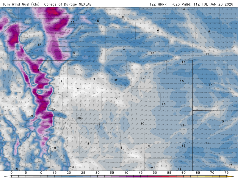
HRRR forecast wind gusts for Tuesday in the Front Range. The strongest gusts will be found in the Foothills and along the Wyoming Border area.
By Tuesday evening, yet another cold front starts sliding south, fully clearing the area by early Wednesday as the shortwave races into the Midwest. Highs Wednesday should land just shy of Tuesday’s numbers—upper 40s to near 50—as return flow sets up quickly behind the front.
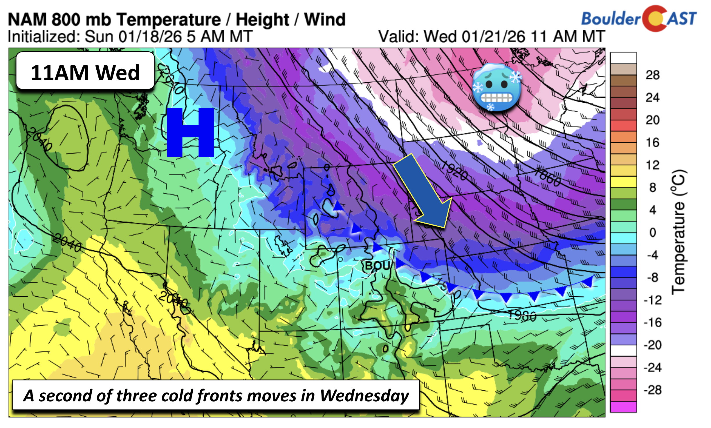
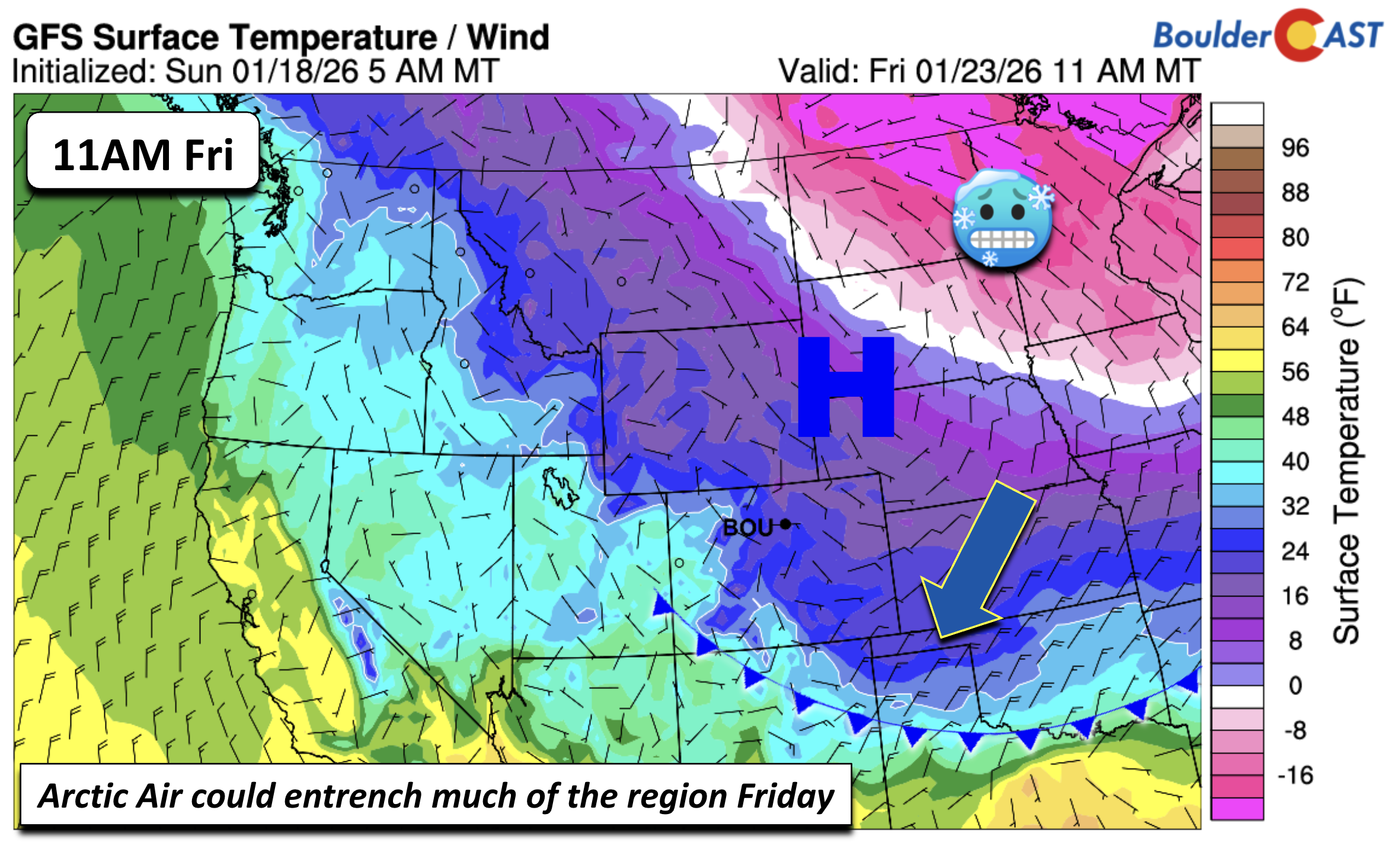
Front number three arrives Wednesday night, and number four—our Arctic one—follows sometime Thursday night into early Friday. This final boundary is the one to watch: it’s loaded with true Arctic air, and our currently forecasted Friday highs in the 20s may be too optimistic. If the cold air spills west faster than modeled (which it often does), Thursday could get swept into the deep‑freeze as well.
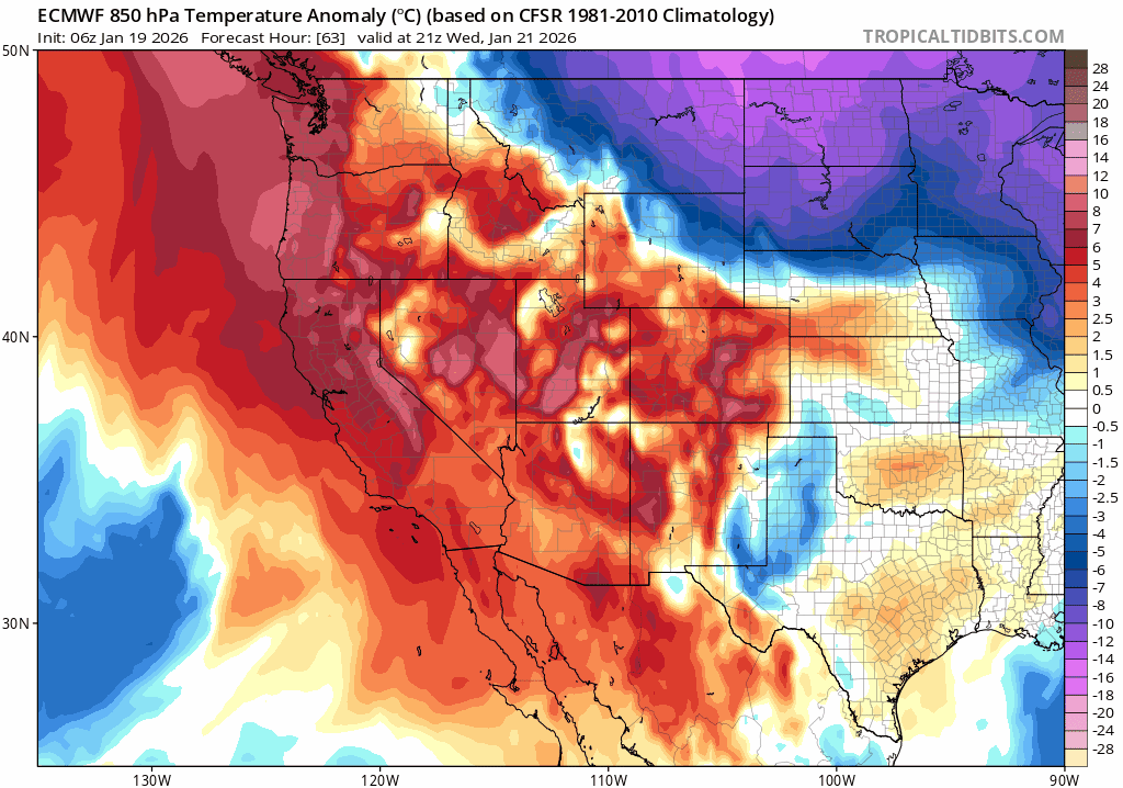
850mb temperature anomaly forecast from the Euro model for the late week period showing Arctic air spilling into eastern Colorado
The Arctic air is expected to surge all the way into the Southern Plains by midday Friday, with the coldest core centered over the Upper Mississippi Valley. For Boulder and Denver, teens aren’t off the table if the cold air undercuts the Rockies more aggressively than shown.
Attached to that late‑week Arctic front is a developing system that models are still in disagreement about. Some guidance (like the GFS) hints at a semi‑split flow with a trough near the Four Corners. Others place the energy farther north into Utah. Regardless of the exact track, the setup supports at least some chance for snow Friday, possibly lingering into Saturday.
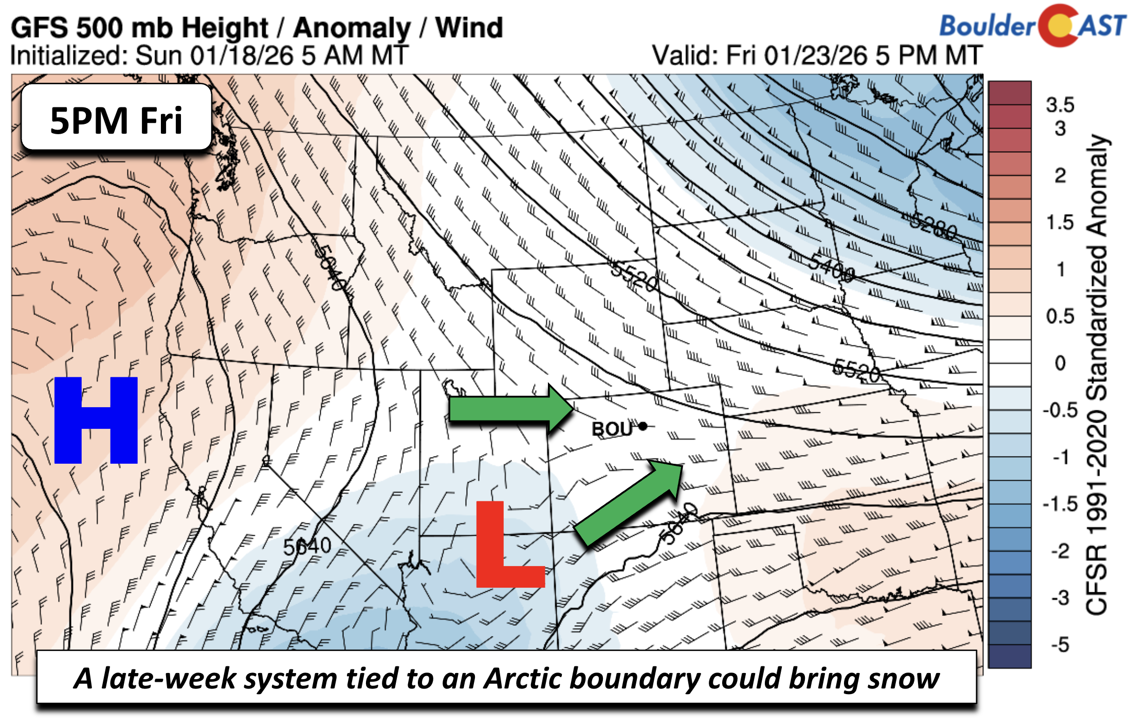
As for snow amount potential, the GEFS ensemble isn’t overly excited—only a subset of members produce meaningful snow Friday into Saturday. But other ensemble suites show a bit more promise.
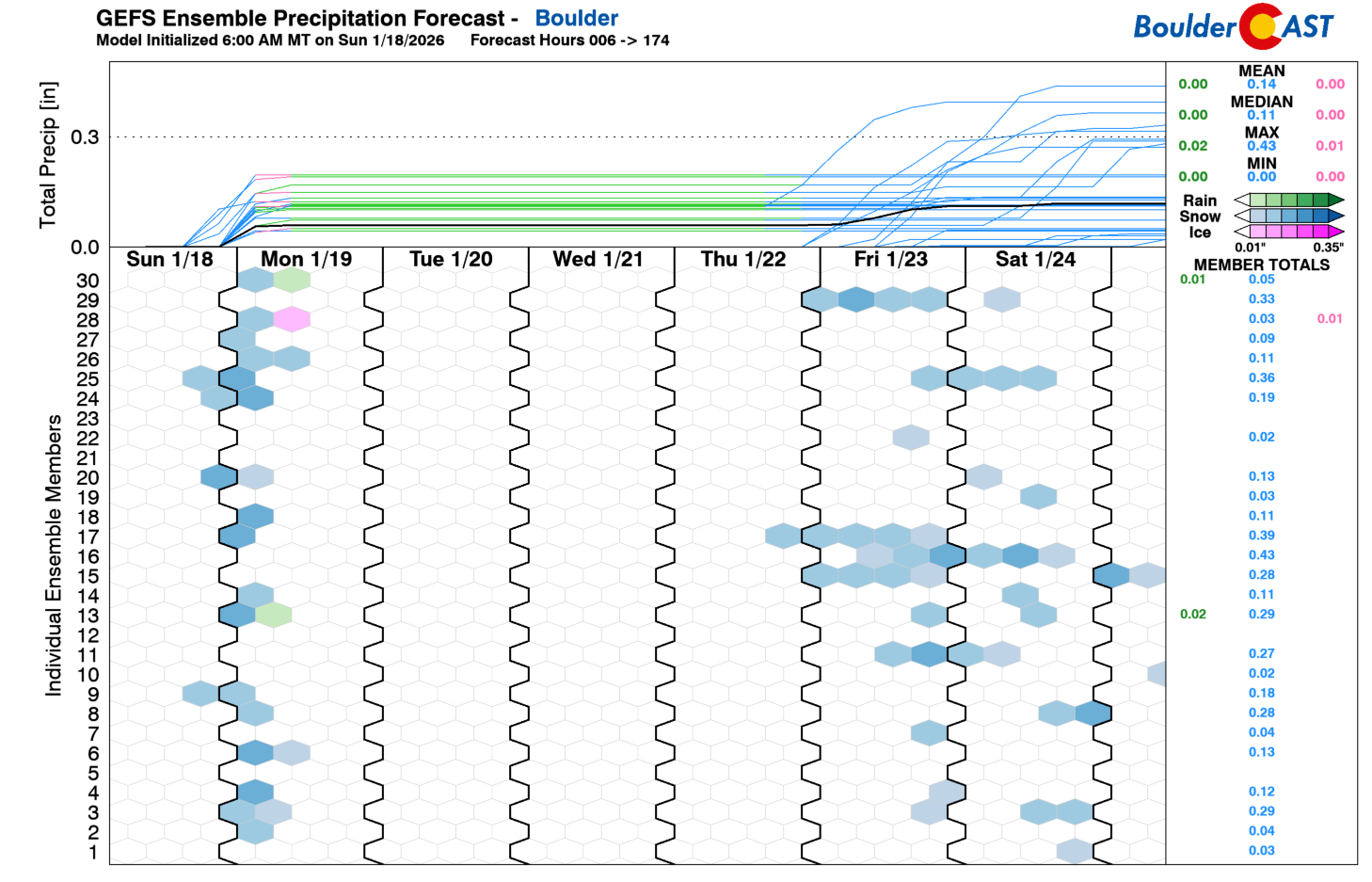
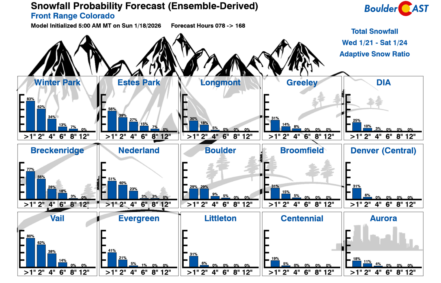
Early snowfall probabilities suggest around a 30% chance of 1–2 inches along the Front Range, with higher odds (40–70%) in the Foothills and High Country. With Artic air settling it, we’d be surprised if we end up completely dry to end the week — a little light snow or freezing drizzle would certainly seem likely from a pattern recognition standpoint.
More of those late-week details will come into focus as we get closer. For now, enjoy the relatively pleasant weather through the week while you can—the Arctic blast eyeing the Front Range at the end of the week will mean business.
Forecast Specifics:
Monday: Cooler, snow ending around dawn, and then quickly becoming sunny. Highs in the low 40s on the Plains and low 30s in the Foothills.
Tuesday: Gusty, warmer, and dry, with an elevated fire danger threat. Highs in the low 50s on the Plains and low 40s in the Foothills, with WNW winds gusting up to 30 MPH on the lower elevations and up to 60 MPH in the Foothills.
Wednesday: A touch cooler but near normal in the upper 40s to near 50 on the Plains and low 40s in the Foothills.
Thursday: Some uncertainty regarding late-week frontal movement means Thursday highs are uncertain. Likely we see highs in the 30s to mid 40s, but it could be much colder if the front is faster.
Friday: Much colder with a chance of light snow. Highs in the 20s in the Denver Metro and the Foothills. The model trend has been colder so highs in the teens are not out of the question, if not likely.
Weekend: An unsettled pattern for the first half of the weekend is possible with snow again Saturday, with below normal highs. A moderating trend may take hold late in the weekend or early the following week with highs returning above normal.
DISCLAIMER: This weekly outlook forecast is created Monday morning and covers the entire upcoming week. Accuracy will decrease as the week progresses as this post is NOT updated. To receive daily updated forecasts from our team, among many other perks, subscribe to BoulderCAST Premium.
Go Premium, get all the perks.
Daily Forecast Updates
Get our daily forecast discussion every morning delivered to your inbox.
All Our Model Data
Access to all our Colorado-centric high-resolution weather model graphics. Seriously — every one!
Ski & Hiking Forecasts
6-day forecasts for all the Colorado ski resorts, plus more than 120 hiking trails, including every 14er.
Smoke Forecasts
Wildfire smoke concentration predictions up to 72 hours into the future.
Exclusive Content
Weekend outlooks every Thursday, bonus storm updates, historical data and much more!
No Advertisements
Enjoy ad-free viewing on the entire site.
Enjoy our content? Give it a share!


Leave a Reply
You must be logged in to post a comment.