The week starts out mild and at times breezy under a split-flow regime aloft combined with downslope flow at the surface. A deep and highly anomalous trough digs across the western US, Colorado, and Great Plains Wednesday and Thursday, bringing snowfall and record cold for late February. Confidence is increasing for several inches of snow to accompany the cold over portions of the Plains Wednesday, primarily from Boulder northward. The Arctic air slowly retreats by week’s end as a ridge in the southeast US builds westward.
This week’s highlights include:
- A strong dipole pattern develops this week across the nation — highly negative height anomalies in the western US (4-5 standard deviations) combine with highly positive height anomalies in the southeast US (3-4 standard deviations)
- The anomalous pattern sets the stage for record cold/warmth across the United States with an Arctic front moving in
- Mild and at times breezy start our week, but we trend much colder Wednesday into Thursday with below zero record lows likely
- Confidence is increasing on several inches of snow on the Plains, especially along/north of Boulder Wednesday
- The Arctic air slowly retreats by week’s end as a ridge in the southeast US builds westward
DISCLAIMER: This weekly outlook forecast is created Monday morning and covers the entire upcoming week. Accuracy will decrease as the week progresses as this post is NOT updated. To receive daily updated forecasts from our team, among many other perks, subscribe to BoulderCAST Premium.
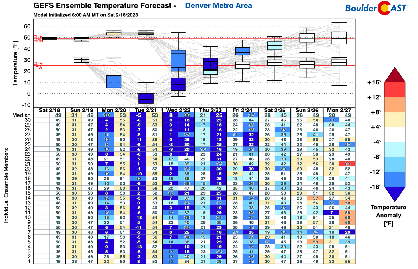
Undoubtedly the big story for the week is the trend from rather mild temperatures to a plunge of record cold Arctic air midweek combined with a decent shot of snowfall. The GEFS temperature forecasts indicate the highs in the 50s Monday and Tuesday. The bottom falls out Wednesday, however, with an anomalous late-season Arctic front and only slowly recovers by week’s end into the upcoming weekend!
Mild and breezy to start the week
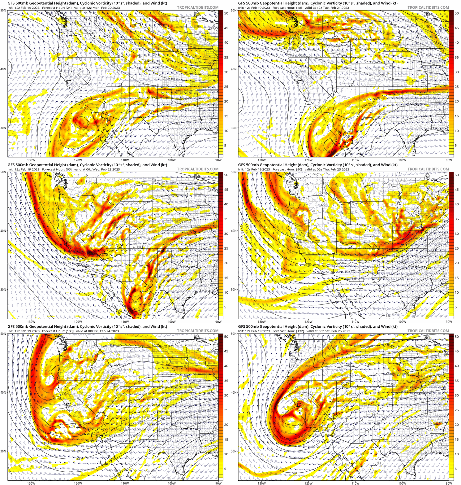
The animation below shows the rough track/pattern of the mid-level flow this week. A split-flow regime to start with downslope flow and a cutoff system near Baja trends toward a large and anomalous trough tracking from the Pacific Northwest into the western/southwest US midweek. This kicks the Baja system into the central Plains and eastern US. At the same time, a larger trough to our west sends deep lift/energy into our region Wednesday and Wednesday night, after which the pattern stays active by week’s end with southwest flow and embedded shortwaves pushing across Colorado. In shorter words, this will be a fun week in Colorado weather!
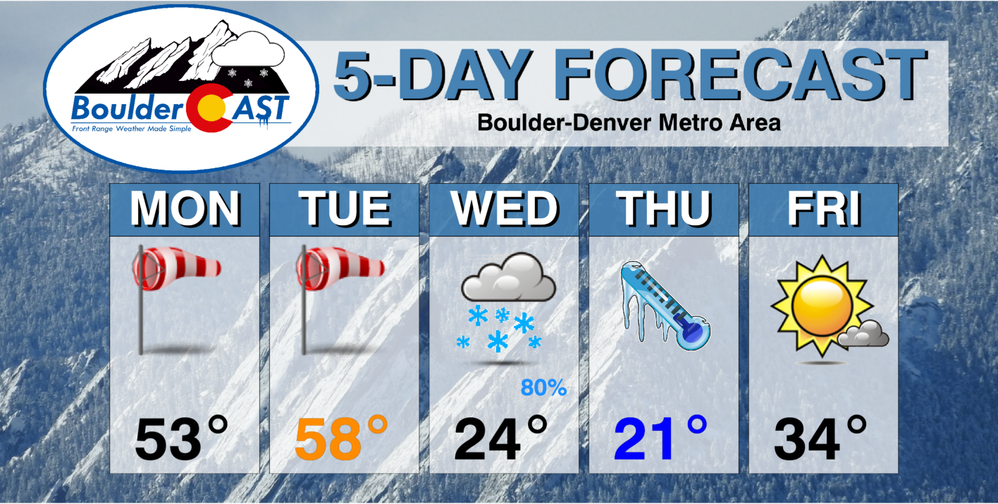
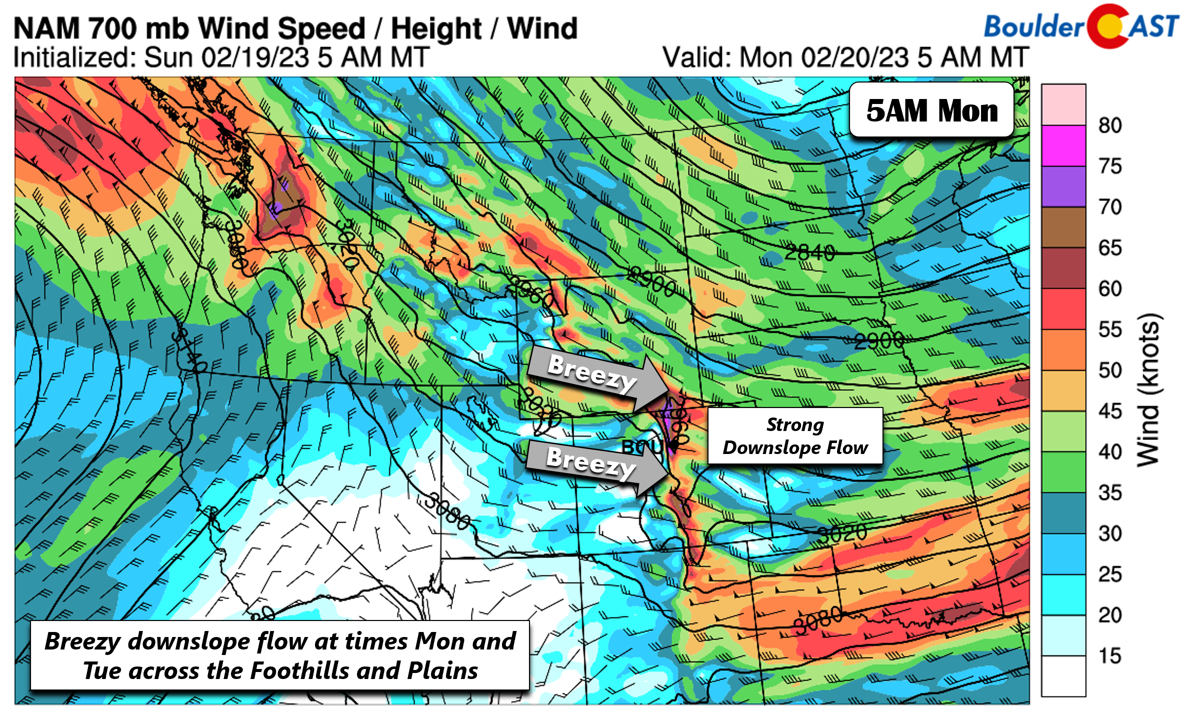
First and foremost — we start the first two days of the week mild and breezy at times. Monday will be the more windy day relative to Tuesday, though both days will have the potential for 30-40 mph gusts on the Plains. A strong downslope flow is largely responsible for this Monday and Tuesday. Wind speeds at 5000 feet up range from 50-80 mph and some of that flow will mix down to the surface for breezy conditions and downslope warming. Gusts of 30-40 mph are favored in the Denver Metro, though in the Foothills, gusts could easily reach 60 and at times exceed 70 MPH during period of mountain wave amplification (which are not easy to pindown this week). So be careful driving along north/south oriented highways for the fear or the cross-barrier flow. This could favor an increased fire danger as well.
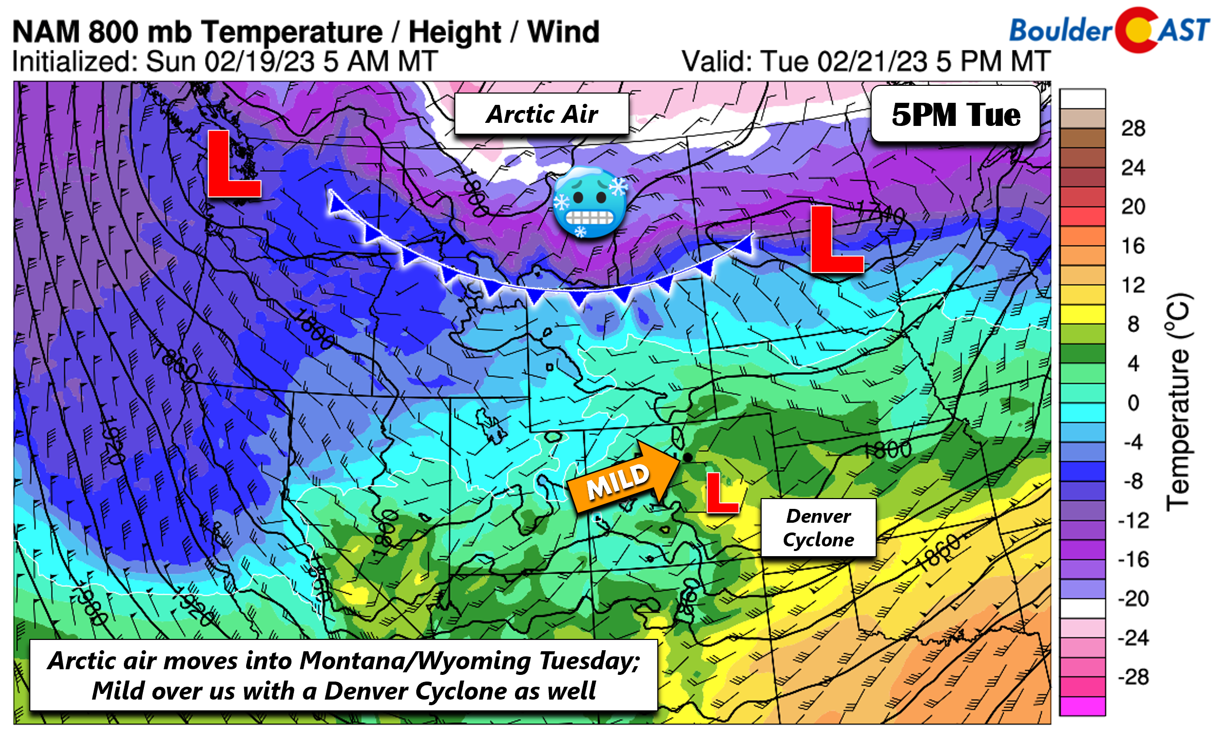
At the surface, downslope warming will push highs in the low to middle 50s today and middle to upper 50s Tuesday. Models are indicating a Denver Cyclone will form just south/east of Denver the first two days of the week, which could also lead to some microclimate variation in high temperatures with varying upslope/downslope flow. Southern parts of the Metro could hit 60 degrees perhaps both days. Overall, though, it’s mild and breezy to start with only wave clouds to be concerned with — outside of that strong wind of course! Arctic air begins to encroach into Wyoming from Montana by Tuesday evening….a sign of things to come for the Front Range!
Highly anomalous pattern brings record cold and snow Wednesday into Thursday
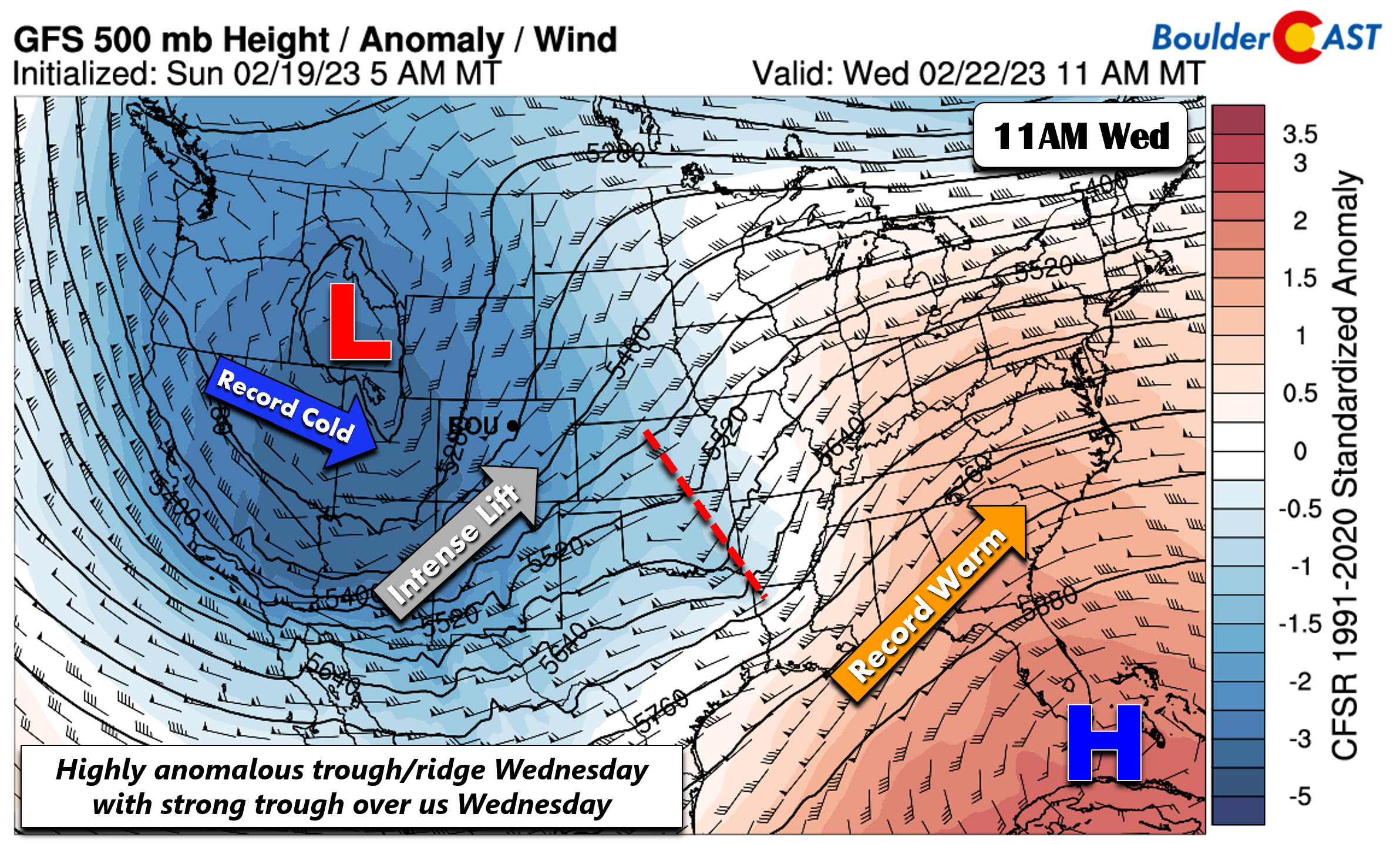
Now for what you are probably most interested in reading…a look at snow chance and that record cold Arctic air moving in later this week. We should preface this by saying that the midweek Arctic Blast will be the result of a highly anomalous pattern, something rarely seen and which will have impacts on the sensible weather across not just our area but the entire nation eventually. Below shows the height anomalies midday Wednesday at 500 mb. Notice the dipole pattern, with highly negative height anomalies tied to our trough in the Intermountain West (some 4-5 standard deviations; 522 dm trough) and a 3-4 positive standardized anomaly tied to a 594 dm ridge near southern Florida. This pattern will lead to record cold in the western US and record warmth in the eastern US. Intense lift will be found over Colorado with the trough on Wednesday. The Baja system at this time is centered near Oklahoma, becoming an open wave with energy streaming into Missouri.
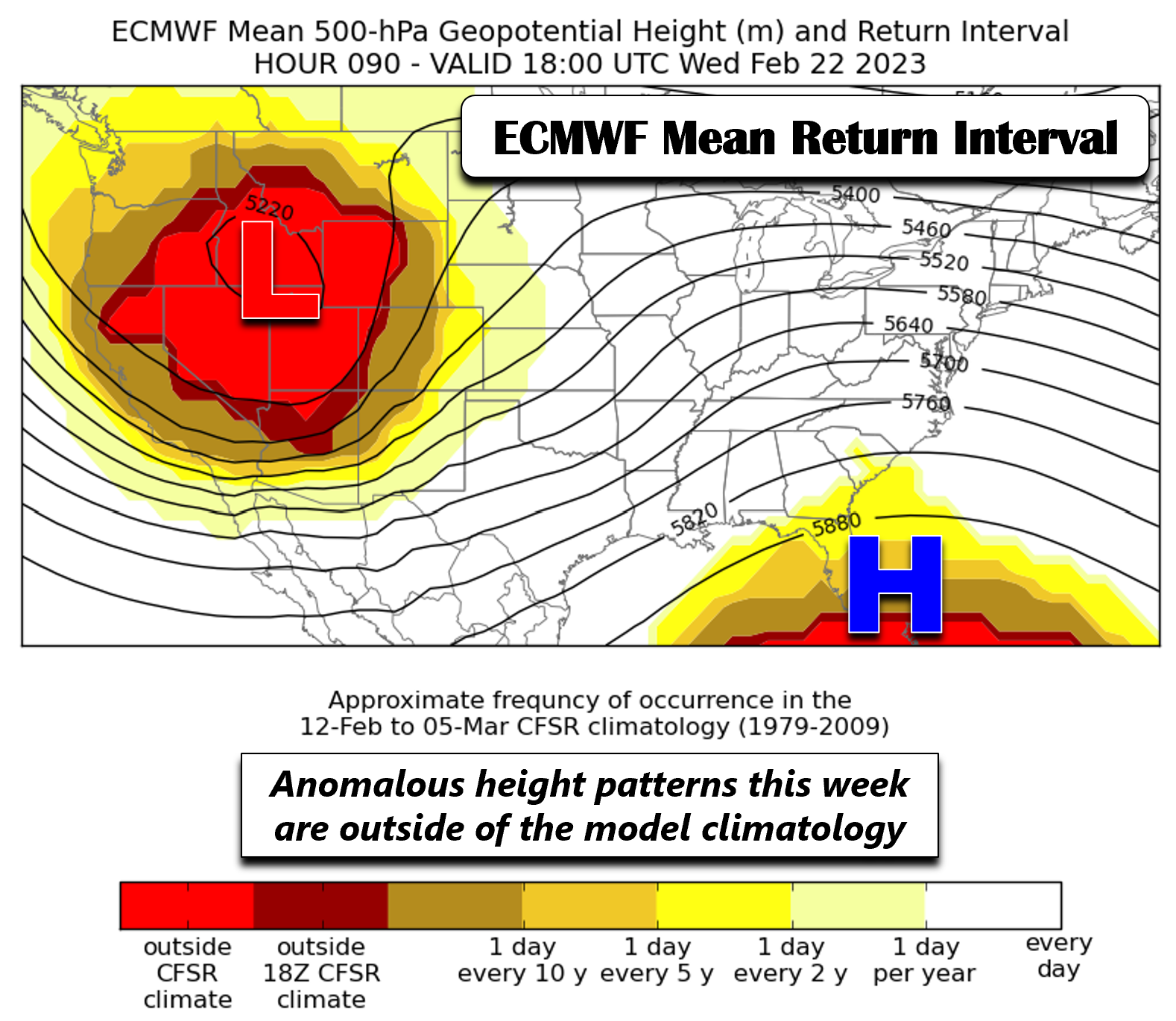
The image below depicts another way to look at the highly anomalous pattern, showing ECMWF ensemble mean return interval of 500-mb heights. The shading denotes how often this pattern of height anomalies occurs. The bright red smeared over the trough/ridge centers suggests these anomalies have not occurred in the ensemble climatology — thus this kind of pattern and trough/ridge strength is very rare!
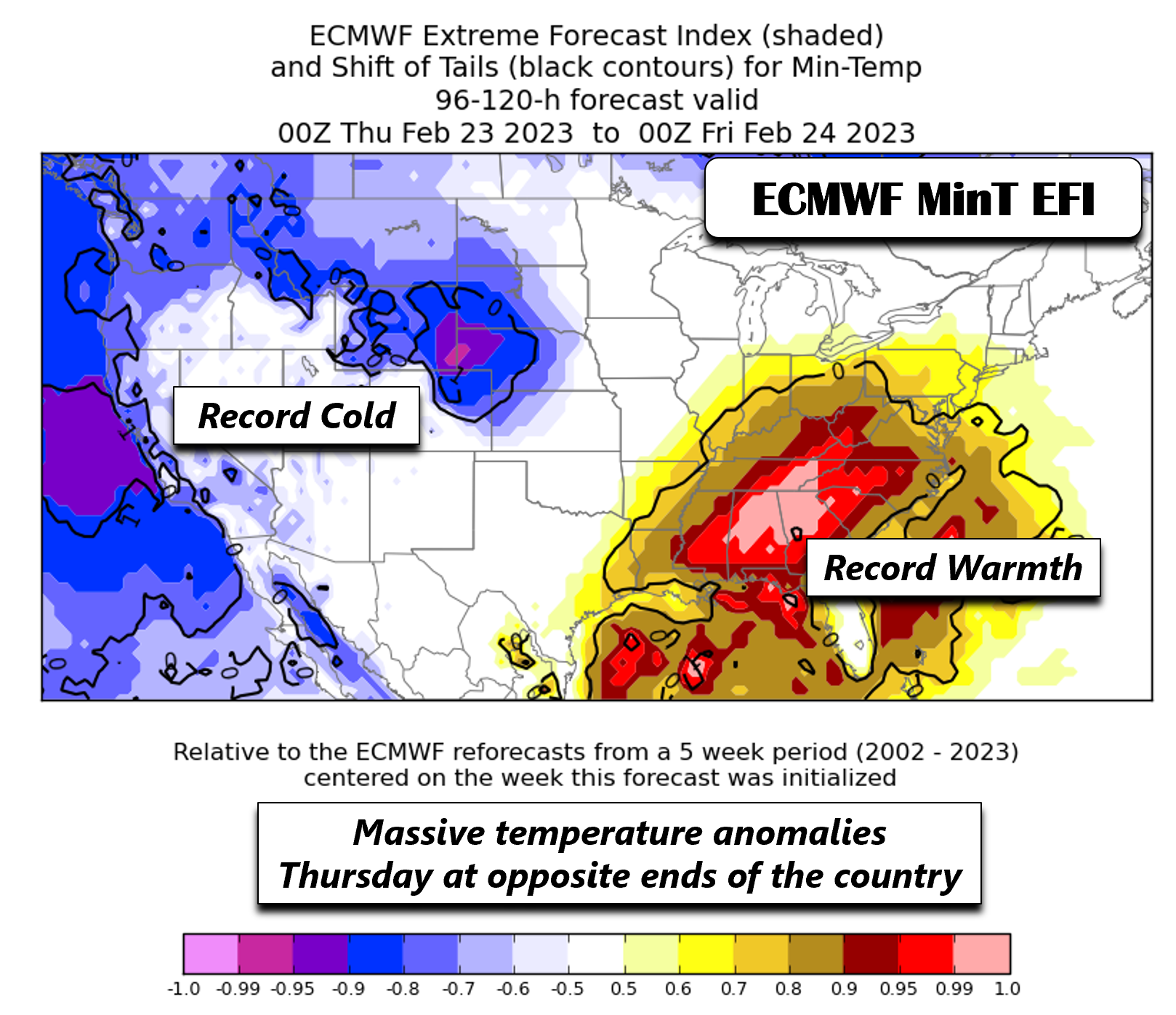
As a result of these opposing height patterns from west to east across the nation, there is going to be record warmth/cold no doubt! The ECMWF extreme forecast index aims to pinpoint regions of the CONUS where anomalous patterns in weather variables could occur. It looks at all 50 members of the ECMWF ensemble. The image below is for minimum temperature. The shaded blue/pink and red/orange colors denote highly anomalous minimum temperatures for Thursday morning. Record lows over us are likely to be broken at this time, with likely sub-zero temperatures. Meanwhile, record warmth is forecast in the southeast US with temperatures in the 60s! Quite the contrast, wouldn’t you say?!
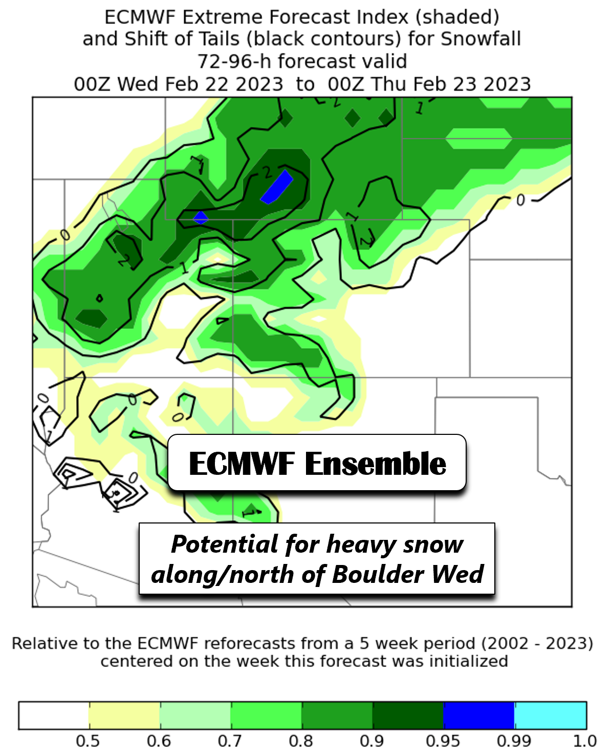
The ECMWF extreme forecast index also looks at snowfall. The dark green shading tell us that many of the ensemble members are forecasting anomalous snow potential Wednesday into Thursday tied to the trough. This parameter is most prominent over Wyoming and Nebraska, which we’ll get to in a second. Still, Boulder/Denver are in the region of concern as well.
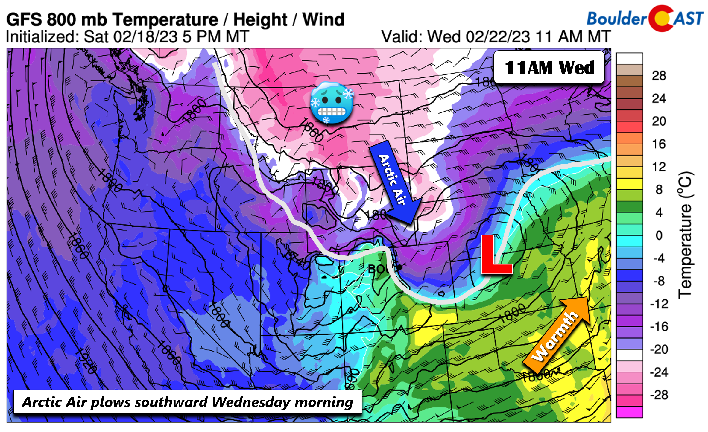
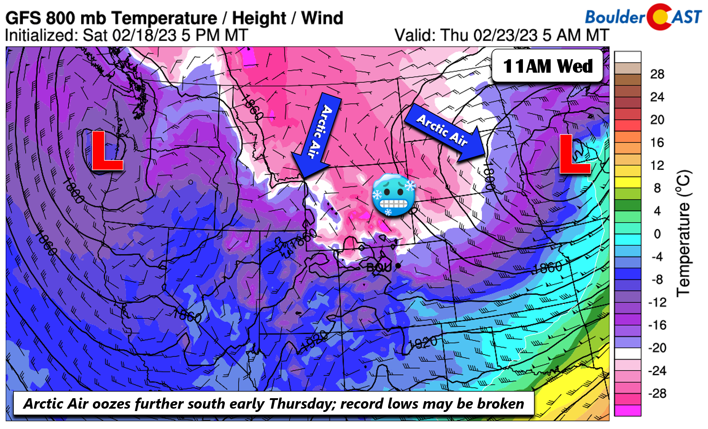
The Arctic front over Montana/Wyoming Tuesday is forecast in nearly all guidance to plow through the Front Range Wednesday morning, as early as 5 AM and as late as 11 AM. That said, you can expect a much different feel to the air Wednesday compared to Tuesday, a nearly 30-40 degree drop from the 50s Tuesday to the 30s and eventually the 20s and teens Wednesday. Upslope flow will ensue behind the front and persist well into Thursday. Our snow chance will develop Wednesday morning and persist into early Thursday morning.
At the 700mb level, or ~5000 feet up, the flow turns more south-southeasterly as models are indicating an area of low pressure forming over the Wyoming/Colorado border in response to the digging mid-level trough. The surface low tracks east into the Plains states so stays to our north. This means there is little upslope aloft, which usually isn’t the best for accumulating snow. However, we still have surface upslope combined with deep lift (aided by difluence) and some potential frontal and jet forcing.
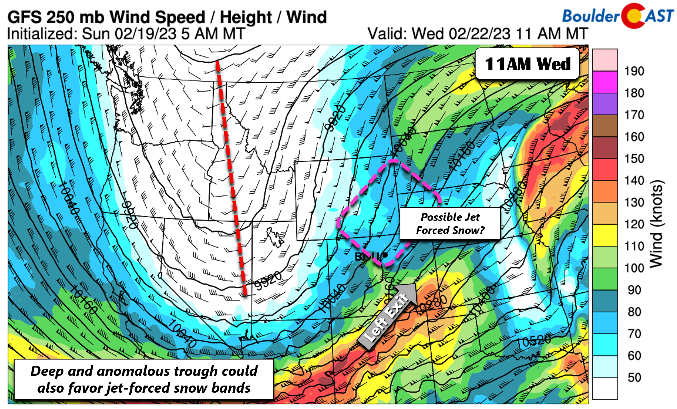
The ECMWF/GFS show that the left exit region of a 120+ kt jet streak over New Mexico and southeastern Colorado, on the southern end of the trough, creep up into northeast Colorado. This could certainly favor jet-forced snow bands, especially along the Wyoming Border and along/north of Boulder. As you go further south into Denver and into Centennial/Castle Rock, the influence from this jet should become less pronounced.
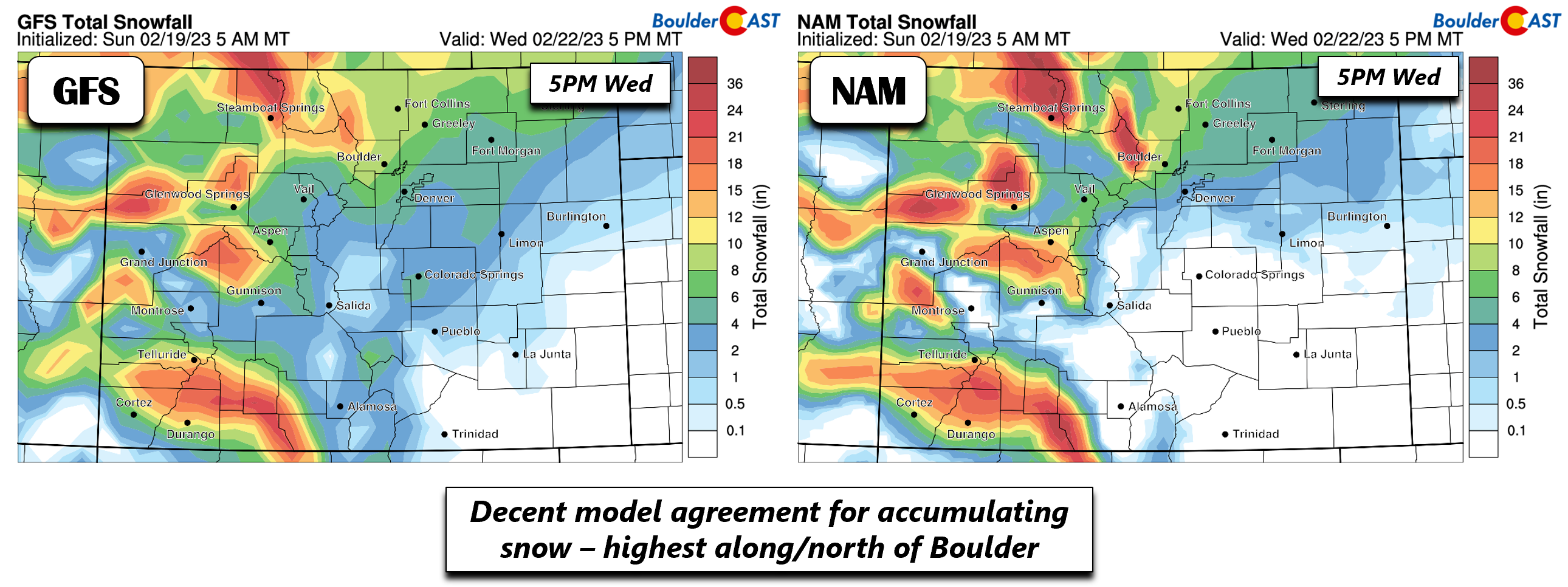
It’s no surprise, then, that the operational GFS/NAM are in fairly good agreement that the highest snowfall amounts will be found along and northwest of Boulder, especially across Ft. Collins and towards the border with Wyoming, near the Cheyenne ridge (influence from upslope along the ridge with southeast winds 5,000 feet up). This heavier snow also includes the Foothills west/northwest of Boulder and RMNP. In the Denver Metro area, however, confidence on amounts is somewhat lower, given the lesser influence from the jet and only shallow less-favorable upslope in this area. The NAM thus indicates a swath of a trace to 4 inches, while the GFS ranges from 2 to 6 inches. In Boulder, we have generally higher confidence of 6-8 inches, with isolated higher totals, especially in closer proximity to the Foothills and toward Loveland/Longmont and near the Cheyenne ridge. Of course we are still 3 days out so things can certainly change. If the trough takes a slightly more north track, it could further shift the heavier snow away from the Boulder area. The GEFS snowfall probabilities are also highest in Boulder of 6 to perhaps 8+ inches. We will update you as it gets closer and provide a snowfall map sometime Tuesday. Any snow would end by early Thursday with clearing skies.
The Arctic air moves little on Thursday, with our coldest temperatures expected Thursday morning, as the bitter cold oozes further south. Record lows will likely be broken in Boulder/Denver. The record lows are only a few degrees below zero and we should easily get into the -5 to -10 degree range, especially under fresh snow cover. We’ll just need to wait and see if the clouds fully clear out by Thursday morning or not.
Thawing out slowly by week’s end
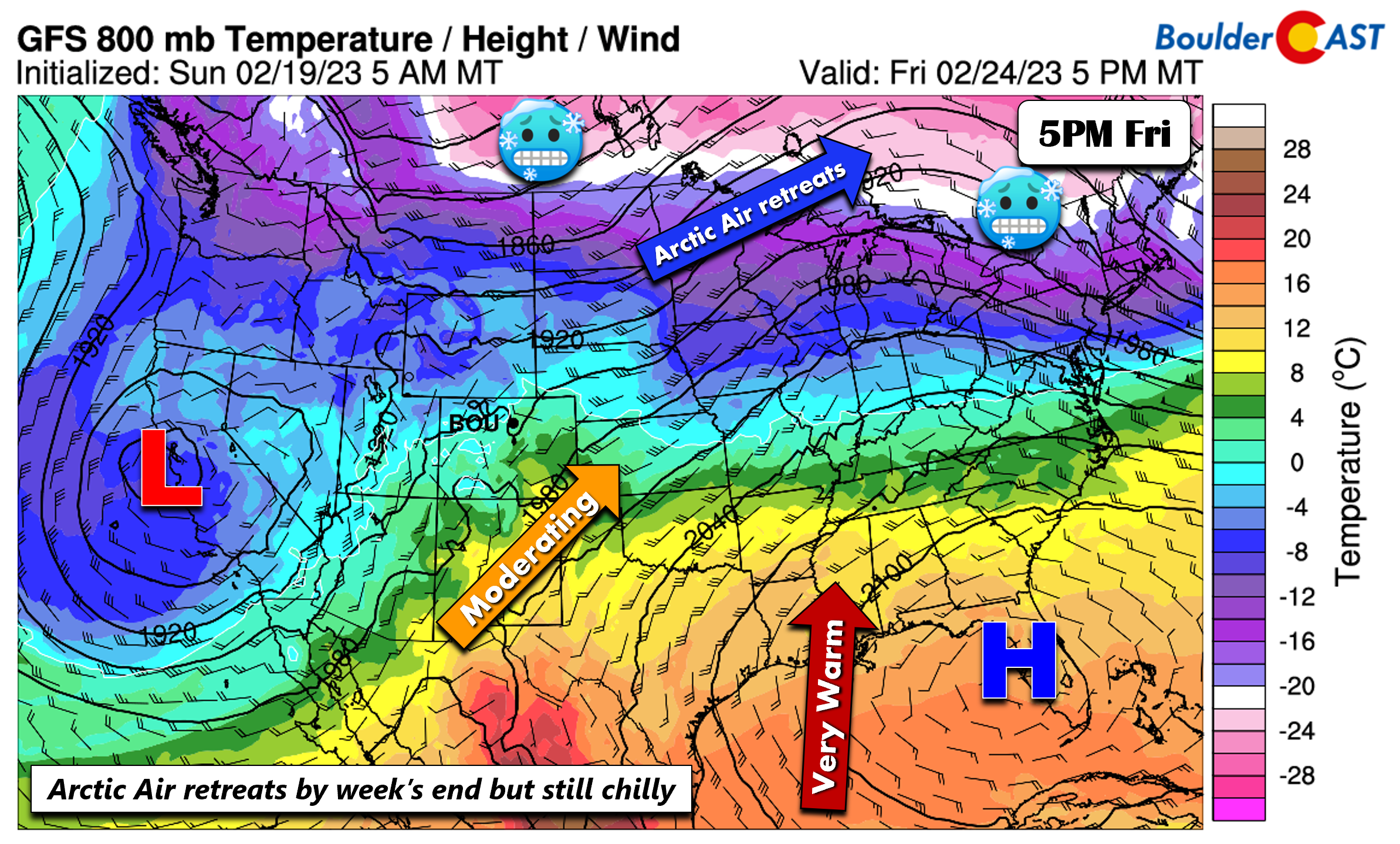
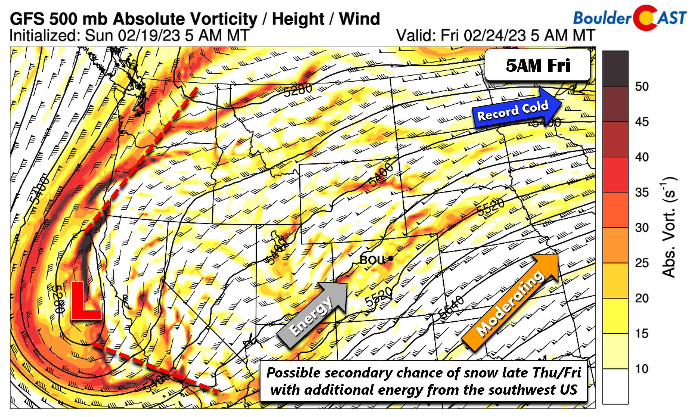
By Friday, models indicate that the anomalous ridge in the southeast US will edge north and west into the southern Plains. At the same time, another cutoff system sets up over southern California, which when combined with the ridge will help to bring in southwest flow near the surface. The Arctic air then should retreat back into Canada and over the Great Lakes. We are somewhat skeptical regarding how fast the models are eroding the cold air as it seems this magnitude of cold usually holds on longer than anticipated. However, given the highly anomalous and transient pattern, this certainly is not out of the question. Our highs in the teens or 20s Thursday may reach the 30s by Friday — model spread with respect to temperatures though remains very high at this point for Friday.
Even with the retreating cold air, the aforementioned cutoff system developing late in the week is forecast to be a nuisance, sending ripples of energy into the state from Arizona. This could favor another low-end chance of snow late Thursday into Friday. Confidence on this event is lower than the one Wednesday, though, given the split-flow regime setting up Friday. This will be something to keep an eye on for sure. A continued moderating trend with temperatures closer to normal is forecasted by the ensembles for the upcoming weekend.
Have a great week!
Forecast Specifics:
Monday: Partly cloudy skies, windy, and mild. Highs in the low to middle 50s on the Plains and low to mid 40s in the Foothills. West-northwest winds may gust between 30-40 mph in the Metro area and exceed 60 mph in the Foothills.
Tuesday: Mild and breezy with increasing clouds. Highs in the mid to upper 50s for the Plains and mid to upper 40s in the Foothills. West winds may gust to 20-25 mph on the Plains and up to 40 mph in the Foothills.
Wednesday: Much colder behind an Arctic front with likely snowfall producing several inches of snow over portions of the Denver Metro and Foothills. Highs in the 20s to lower 30s early in the morning dropping into the teens by the afternoon/evening.
Thursday: Possibly a few lingering morning clouds/flurries giving way to partly sunny skies. Very cold with highs only ranging from the teens to the lower 20s in the Foothills and Plains.
Friday: Moderating temperatures but remaining below normal with highs possibly near the low 30s for the Plains and lower 20s in the Foothills.
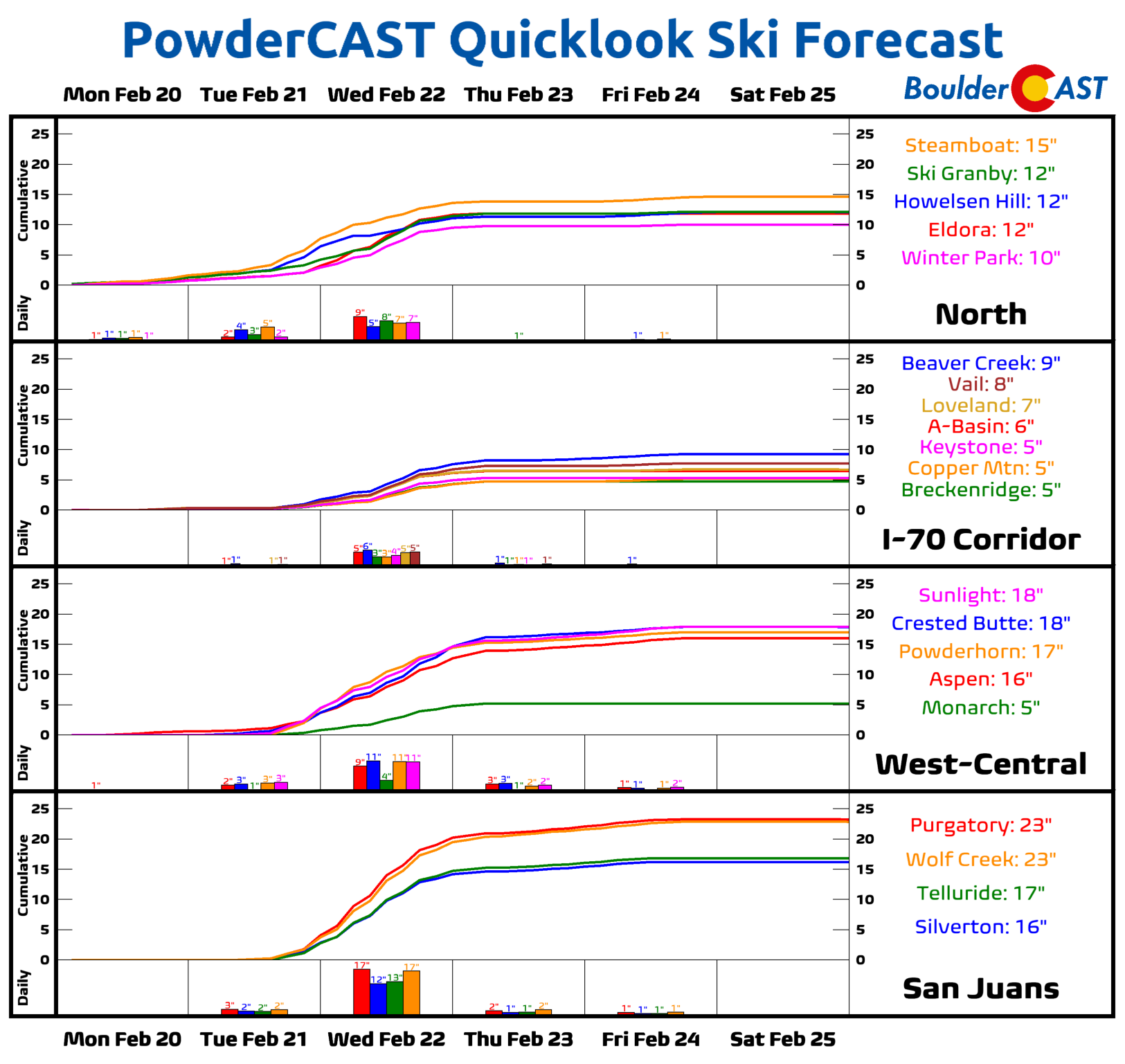
PowderCAST: Windy conditions will be likely Monday and Tuesday, at times exceeding 60 mph over the higher and more exposed peaks/terrain. Accumulating snowfall is likely across the entire High Country, ranging from 6-12 inches and isolated locations of 1-2 feet possible Wednesday into Thursday. Additional light snow is possible Thursday and Friday with another shortwave system. Temperatures near/above average will trend anomalously cold by midweek.
Help support our team of Front Range weather forecasters by joining BoulderCAST Premium. We talk Boulder and Denver weather every single day. Sign up now to get access to our daily forecast discussion email each morning, complete six-day skiing and hiking forecasts powered by machine learning, first-class access to all our Colorado-centric high-resolution weather graphics, bonus storm updates and much more! Or not, we just appreciate your readership!
Spread the word, share the BoulderCAST forecast!





You must be logged in to post a comment.