
After a nearly two week hiatus in accumulating snowfall, the white stuff returns to the Front Range Tuesday night into Wednesday with a long-duration light snowfall event knocking on the door. Let’s take a look at the latest timing, snowfall amounts, and impacts of the impending winter storm.
Premium Storm Update (2/14/23 3:00PM): Things are coming together nicely with our storm and the snowfall developing late Tuesday evening remains on-track. We run through a final check of the models regarding snow amounts, including a discussion of low and high-end potential for this storm and when it will finally wrap-up on Wednesday! READ HERE
Snow finally returns to the Front Range
As on storm system departs southeast Colorado, another approaches from the Pacific Northwest. This advancing storm admittedly looks rather disorganized on satellite this morning, visible as a handful of weak shortwave disturbances across the northwestern United States.

GOES-East mid-level water vapor satellite animation from early Tuesday morning
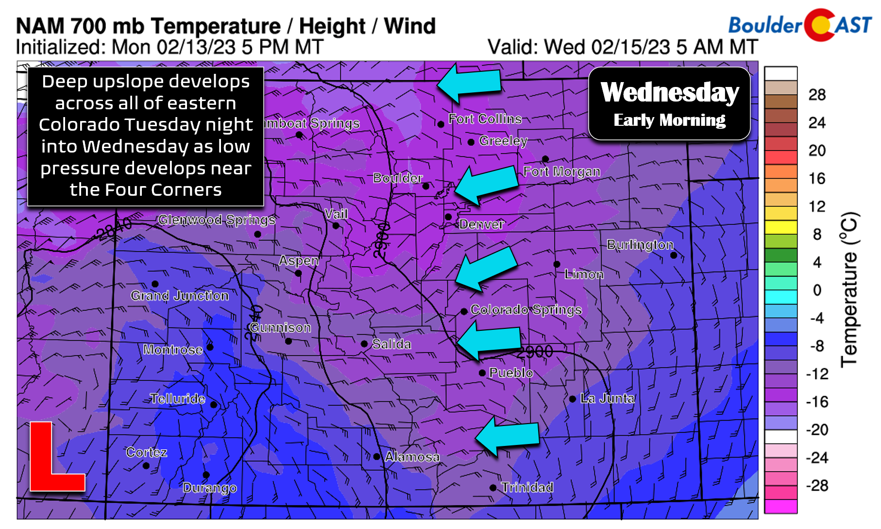
This jumbled mess will consolidate into a single mid-level closed-low pressure system by Wednesday morning very near to the Four Corners. It will then weaken as it passes along the Colorado-New Mexico border on Wednesday — but by that point the wintry damage will have already been done here.
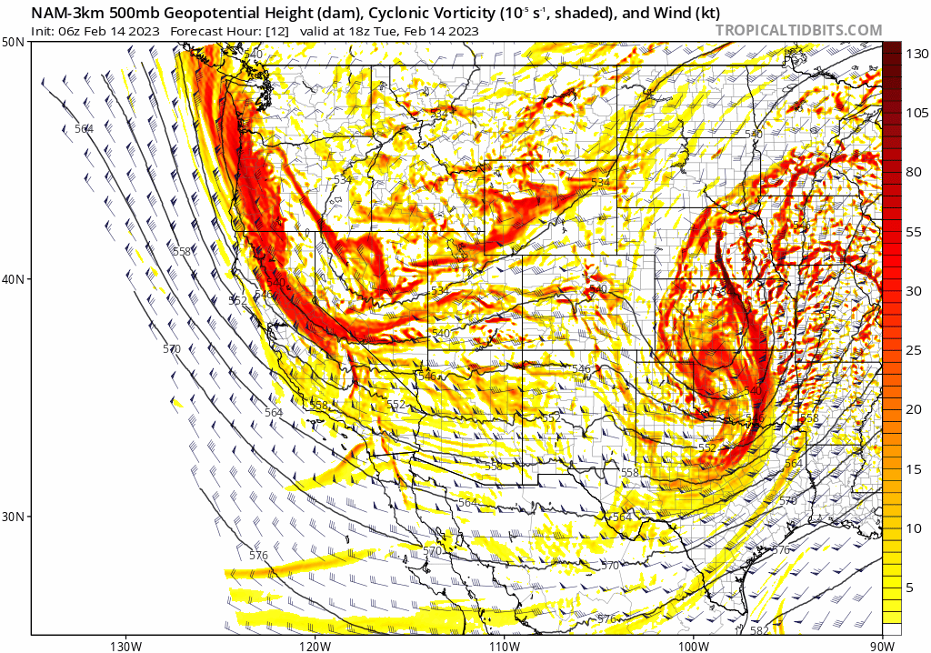
This evolution of the storm will produce a lengthy period of deep upslope and weak large-scale lift across almost all of eastern Colorado allowing for widespread snow to develop. It takes a very specific setup to support upslope coexisting from the Wyoming to New Mexico borders — that is exactly what will be unfolding tonight! Nonetheless, the magnitude of the upslope won’t be that strong, but it will help to focus the snow in the Metro area towards the terrain.
Since our last update Monday morning, we have seen models trend just a hair further northeast with the storm’s track and a tad slower overall, which perhaps is a good sign for those that want more snow here. However, the best forcings for snowfall are still expected to be across the southern tier of our state — the area that has largely been spared this winter and desperately needs the moisture!

The southern bias with this particular storm is evident in the latest Euro and GFS precipitation forecasts below. Northern Colorado is definitely on the fringe of things for this event, with places like Fort Collins and Greeley not likely to see more than 1-3″ of snow at best.

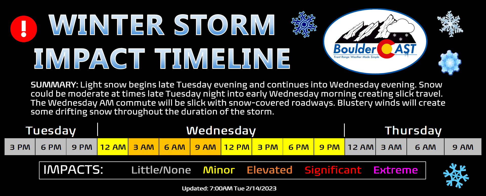
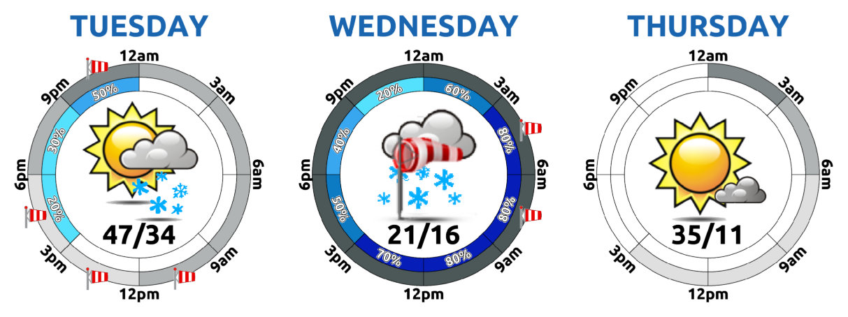
Here in Boulder and Denver, snow will begin late Tuesday evening with most models showing the action beginning sometime between 9PM and midnight. Prolonged northeasterly upslope and weak lift, combined with fluffy snow ratios around 15:1, should produce several inches of snow for all of us by the time things wrap-up Wednesday evening. However, as usual, we are expecting a decent gradient in snowfall totals with amounts highest south and southwest and lowest northeast across the Front Range. This spatial pattern is shown nicely by the latest high-resolution HRRR model run’s snowfall forecast:

Our snowfall forecast map for the impending event is shown below, covering all snowflakes falling late Tuesday evening through Wednesday evening. We’ve made only tiny changes from our preliminary forecast map issued on Monday, mainly just upping totals an inch or so across the board due to recent model trends. The Foothills of Jefferson and Boulder County will see the most snow, up to 9″ in some cases. Remember, this is a long duration snowfall event! You won’t see all of this accumulation on the ground by sunrise Wednesday! Light snowfall — with rates ~1/4″ per hour — is expected to persist all day, fully wrapping up sometime Wednesday evening.
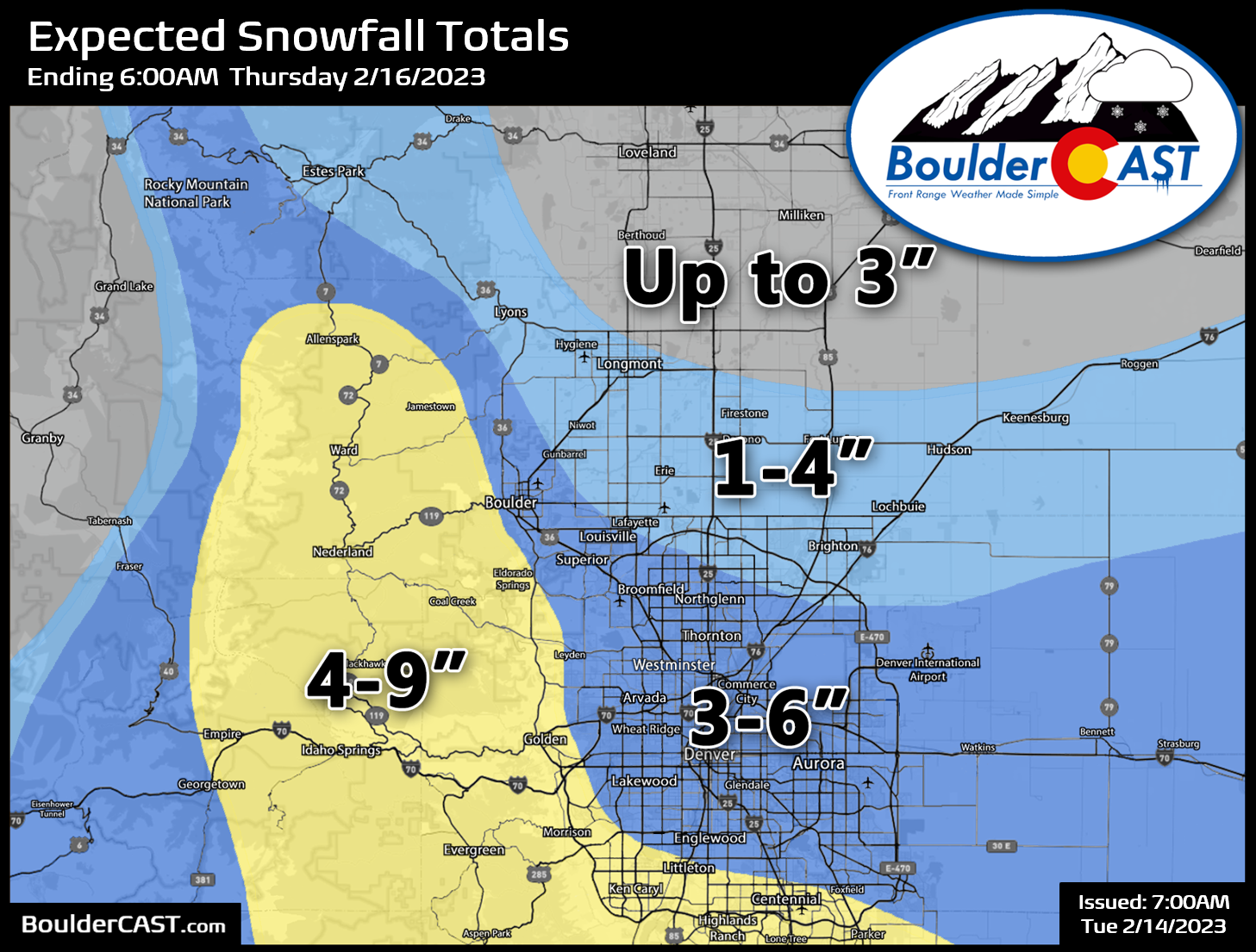
Our latest Snowfall Probabilities show almost a guaranteed 2″ of snow, with just a slight chance to exceed 6″. Our gut feeling for Boulder will land somewhere between 4 to 6″ from this one.

The greatest impact on travel will occur late Tuesday night into early Wednesday, making for a slick and snow-covered morning commute in many areas. Plan for a little extra time getting the kids to school or heading to work Wednesday morning. Though snow will continue through the day, road conditions should improve helped along by the mid-February sun angle. Blustery north-northeast winds much of Wednesday will create areas of blowing and drifting snow, especially out east of Denver. Definitely expect some problems if flying in and out of DIA on Wednesday, but nothing too bad!
Don’t forget the cold! The persistent gusts and cold temperatures will plummet wind chills into the single digits or even slightly below zero much of the day on Wednesday. Bundle up if spending significant time outdoors.
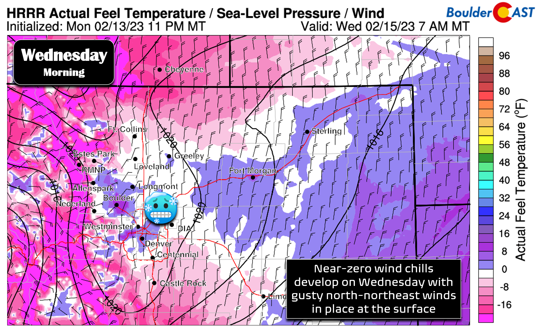
As of writing, Winter Weather Advisories have been posted for portions of the Metro area, including both Denver and the “flat” part of Boulder County.
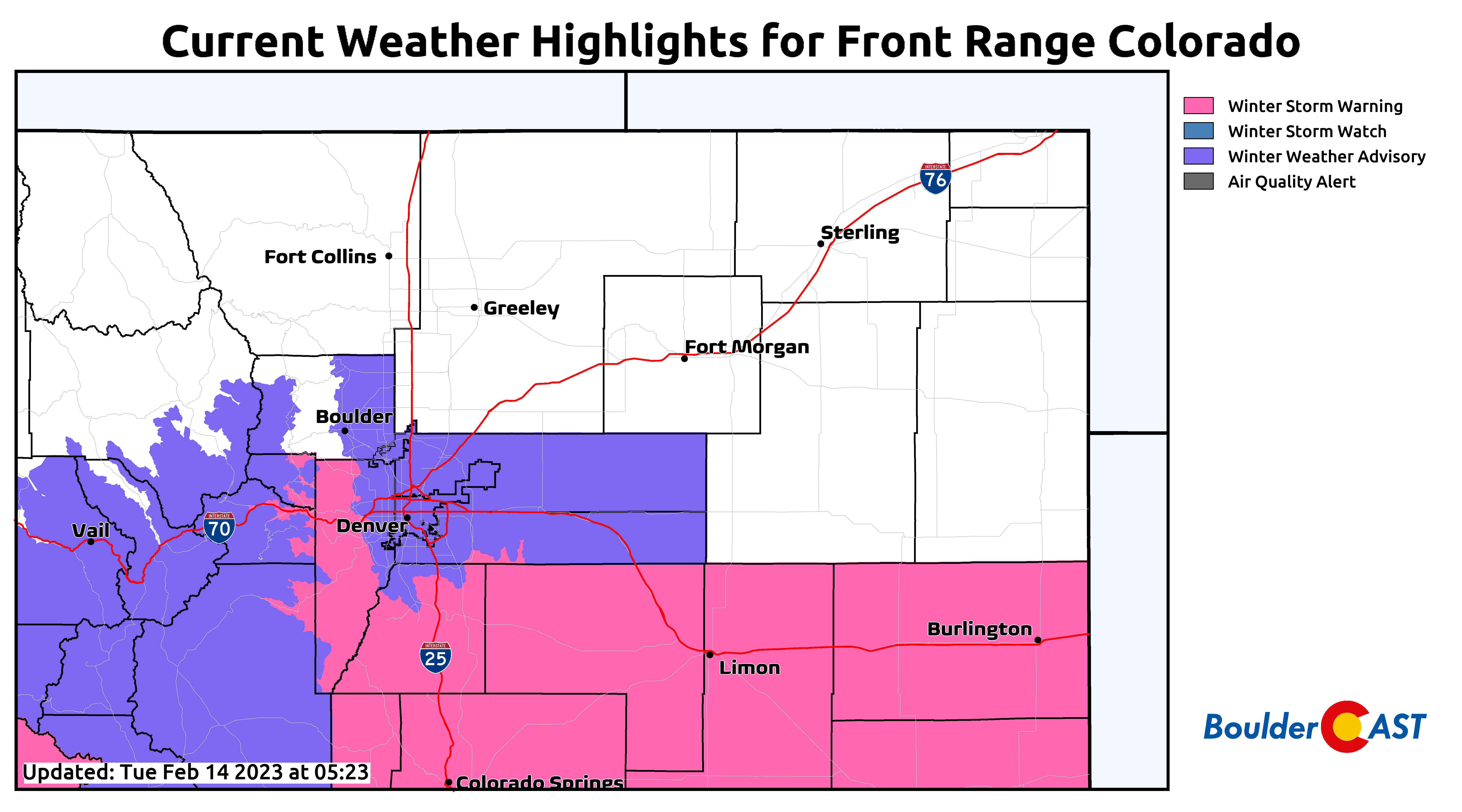
Zooming out, the storm’s heightened impact on the southern tier of the state is evident with a cornucopia of Winter Storm Warnings to our south, including the Palmer Divide and Jefferson County Foothills.

All in all, this should be an interesting snow event accompanied by pretty cold air. Despite the weak dynamics, the shear length of the storm will help get us several inches of snow. We’ll post one final discussion of the updated model data later today on BoulderCAST Premium. Otherwise, enjoy the return of the snow!
Get BoulderCAST updates delivered to your inbox:
Enjoy our content? Give it a share!


You must be logged in to post a comment.