
Mother Nature does some of her best work this of year! No other place and time can offer the extremely rapid changes in weather like Front Range Colorado can during the month of April. We take a look at how Boulder went from near 80 degrees on Sunday afternoon to a blanket of snow in just over 24 hours.
Winter’s last gasp?
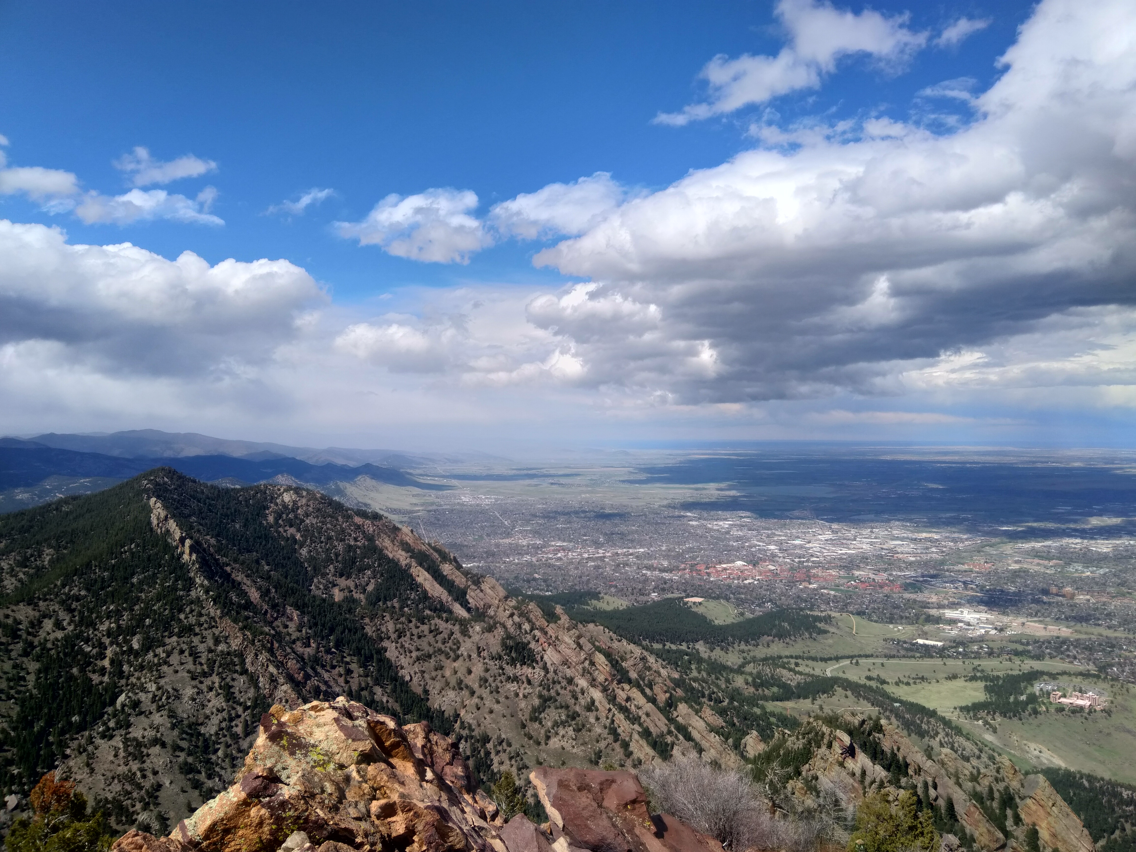
Can you believe that the photo below is from a hike we did in Boulder Sunday afternoon? What a change one day can make!
The highest temperature we reported at BoulderCAST Station was 77°F Sunday afternoon around 1:00 PM. By 5:00 PM Monday, the temperature had plummeted to a chilly 30°F with moderate snow falling across the city. That’s a 47°F drop in only 28 hours!

Weather observations from BoulderCAST Station on Sunday and Monday.
The atmospheric set-up that brought snow back into our forecast was well-advertised by the global weather models, though the devil was definitely in the details as the storm didn’t necessarily play-out as expected.
- Initially it looked as though moist southwesterly flow in the mid-levels would be a major factor for the event, over-running the cold air across the Metro area. This was the result of two storm systems that were shown to merge across the state of Colorado.
- However, as the commencement approached, models backed away from this outcome and instead favored two discrete, non-merging disturbances. This ultimately led to a warmer trend in the models and was the reason we expected some areas to struggle changing over to snow.
- Overall, Monday was a major bust on most accounts by all the major weather models. Some of the missteps worked to increase snow totals, while others hurt totals
- Temperatures were shown to climb into the mid to upper 40’s (which we knew was unreasonable). However, extensive cloud cover and even some spotty showers Monday morning helped keep temperatures very cold across the lower elevations. Boulder’s daytime high was only 35 degrees (30 degrees below normal and very nearly a record for the date)
- Temperatures remained so cold for most areas that rain wasn’t even a possibility. Our predicted downsloping into south and east Denver did verify and allow for rain there, though.
- Snow began earlier than expected which definitely had some of you upset and convinced it was going to be huge snowstorm based on the emails we received!
- The final model runs before the heavier snow began Monday afternoon had reduced the extent of deep upslope into our area and replaced it with due southerly winds. This cut precipitation totals by at least 25% and as much as 50%, depending on the model. We discussed these changes in our Premium storm update Monday evening

Observations of wind with time and height from Platteville, CO. The top of the upslope is indicated by the red line. Period of falling snow are outlined in pink.
- High-resolution models began to show that energy from the jet would indeed impact the area north of Interstate 70. This was something we thought would happen, but there was really no agreement until the final hours. The target was clearly on Fort Collins and Cheyenne, but Boulder was less certain.

Radar images of jet-forced heavy snow bands across the Boulder area Monday afternoon (left) and night (right)
So as it happened, despite the flop on upslope, moist over-running and precipitation amounts, the combination of colder temperatures and spotty jet-forced snow bands made up the difference and our snowfall forecast turned out surprisingly well. As they say, even a blind squirrel finds a nut once in a while!

So how much snow fell? Shown below is our snowfall forecast map issued Monday morning with storm totals overlaid in boxes. Green ones indicate that our forecast verified to within one inch of the observed snowfall. Red did not. Overall, the forecast turned out good for the entire Plains, but Foothills locations came up short. This is ironic considering our confidence in the forecast was much higher in the Foothills, and rather low for the Plains. As you can see, 2 to 4″ of snow fell around Boulder, 1 to 2″ in Denver, and less than 1″ southeast of Denver. This is exactly that pattern we outlined in our forecast. The big winner, a city not very familiar with the snowfall winners podium, Estes Park! A series of those slow-moving heavy snow bands dumped 10″ of wet snow there.
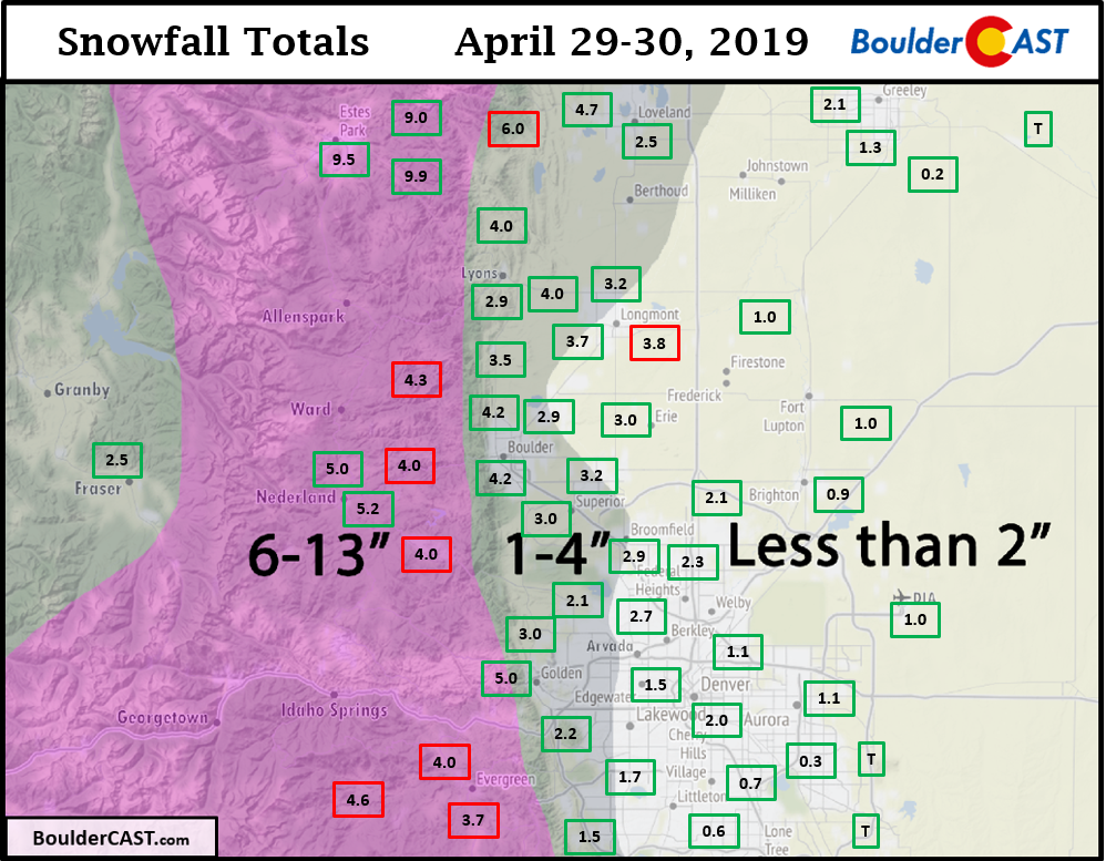
Officially, 4.2″ of snow was reported in Boulder and 1.0″ in Denver.
| Seasonal Snow Totals (Updated Apr 30 2019) |
|---|
| Boulder | Denver |
|---|---|
| 86.6" | 43.9" |
The rest of the week remains relatively cool and unsettled with a pesky trough lingering across the northern Rockies.

We’ll have a chance of primarily afternoon and evening rain showers with some snow possibly mixing in, especially Tuesday and Wednesday. Friday and Saturday are looking quieter and warmer with temperatures getting back to near or slightly above normal. 70’s sound amazing right about now, don’t you think?
Share this post:
.


You must be logged in to post a comment.