This week will begin and end rather mild, but sandwiched in between will be the return of bitter cold temperatures and widespread snowfall. Though models have trended further south with the midweek snowstorm, everyone should pick up some of the white stuff. Let’s take a look at the roller-coaster of weather set to unfold this week in the Front Range.
This week’s highlights include:
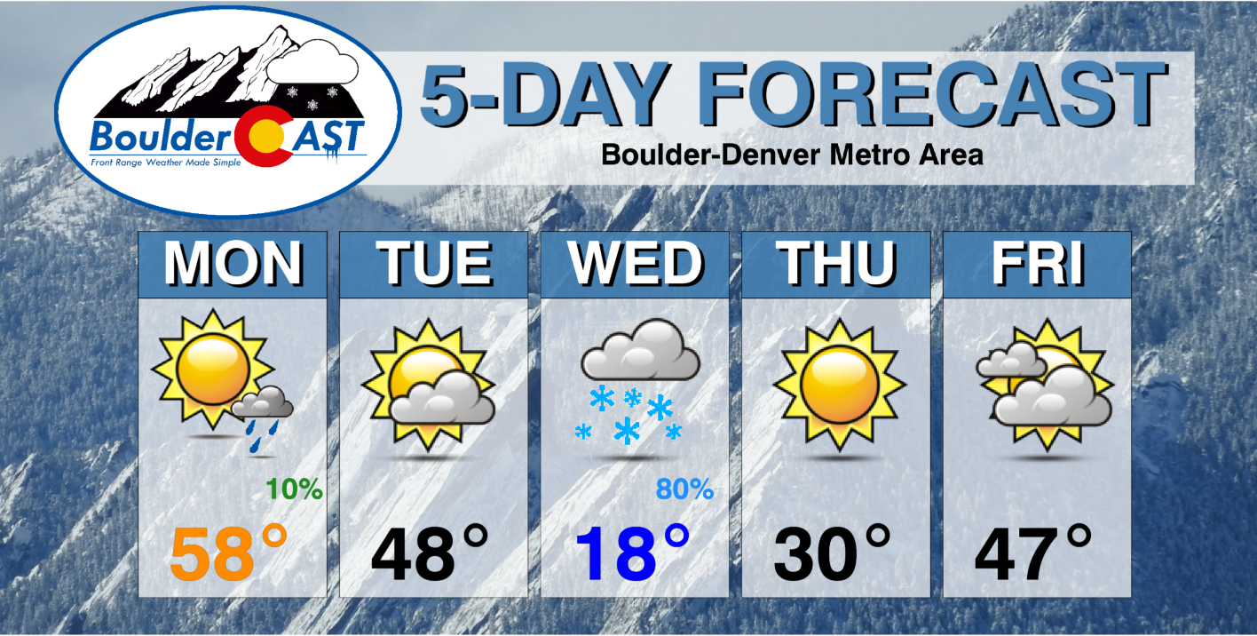
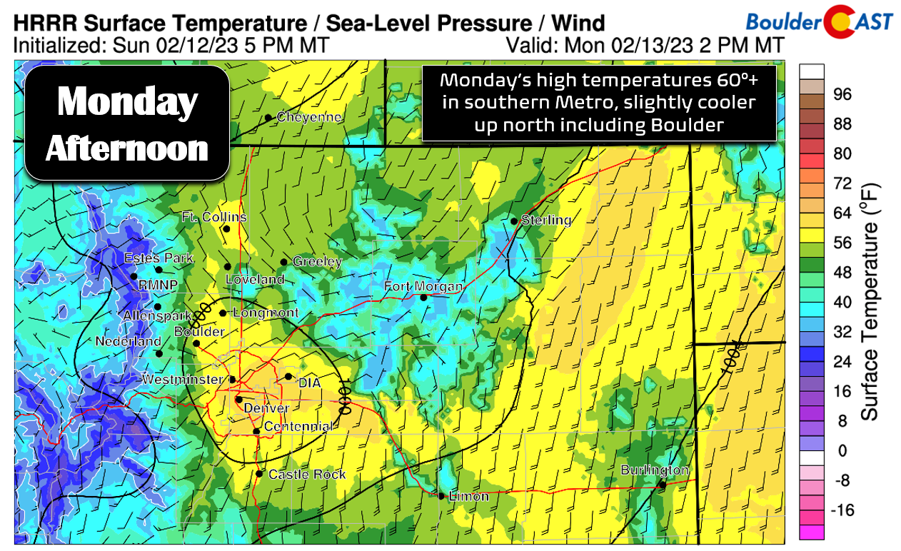
- Close to 60 degrees on Monday under mostly sunny skies
- A weak system scoots south of the area Monday night bringing a slight chance of showers followed by cooler temperatures for Tuesday
- The incoming snowstorm has shifted track slightly south taking the heaviest snow with it
- Still expecting a prolonged period of light snow in the Denver Metro area Tuesday evening through much of the day Wednesday
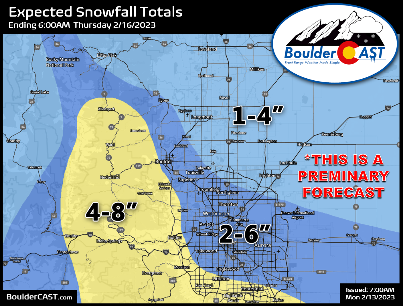
- Snow totals, while not overly impressive, look to be 2-6″ for our area, highest south and southwest
- The week ends tranquil and seasonal with high pressure building in from the west
DISCLAIMER: This weekly outlook forecast is created Monday morning and covers the entire upcoming week. Accuracy will decrease as the week progresses as this post is NOT updated. To receive daily updated forecasts from our team, among many other perks, subscribe to BoulderCAST Premium.
A pleasant start to the week
Undoubtedly the hottest topic on everyone’s mind this week is the approaching snowstorm set to move into the area Tuesday night. It’s likely not going to be a huge event for us, but we’ll get to those details in a moment…
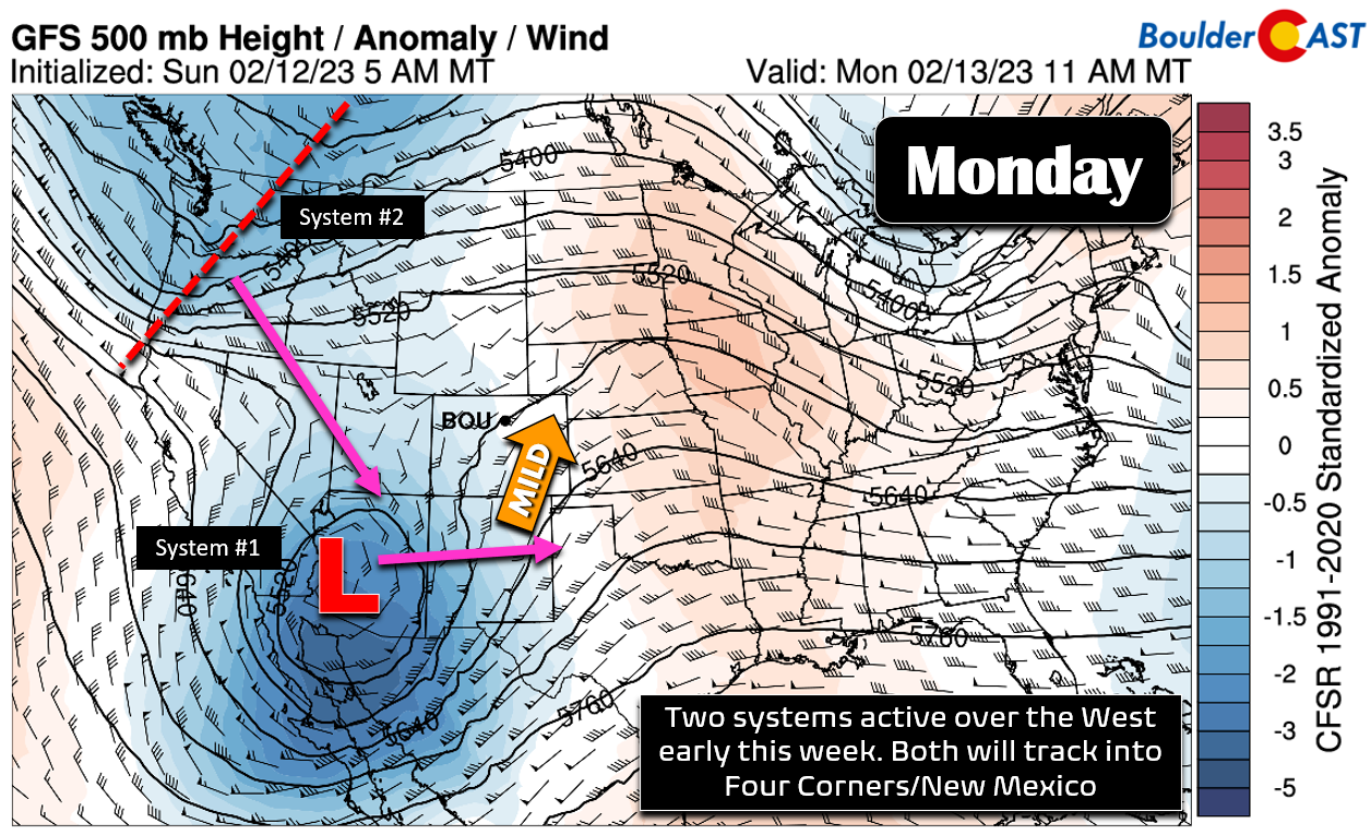
First and foremost— before things ultimately trend colder and snowier — Monday and Tuesday will be rather pleasant across our area under a broad southwest flow pushing into Colorado. The pattern across the West is far from benign, however. As of Monday morning, there’s a cut-off low spinning in Arizona which will track across New Mexico in the next day or so — this low is enhancing that southwest flow on Monday. A secondary system dropping out of western Canada will enter the fold Tuesday into Wednesday. That one will end up being our snow-maker.
Monday will be quite mild in the Metro area with highs approaching the rare 60-degree mark, plus or minus a few degrees depending on how much of a Denver Cyclone sets up. For those that are counting, officially Boulder has recorded just two 60-degree days in 2023. Denver has had ZERO thus far!
Our daily planner shows increasing clouds through the day Monday. There is a slight chance of a brief rain or snow shower this evening after dark as some upper-level energy passes through (~5-10% chance). Most of us remain dry, but a few areas could see sprinkles or flurries depending on elevation.
That first system will scoot past us Monday night well to our south with next to no precipitation for us, but it in the process it will bring a slight windshift drawing in cooler air to the Metro area for Tuesday. This will drop our highs back into the 40s with more cloud cover around. The approaching snowstorm should hold off until after sunset Tuesday evening.
Snow & cold return by midweek
Now on to the snowstorm targeting the Front Range Tuesday evening into Wednesday — you know, the one that has been hyped-up already by the media in typical fashion despite significant uncertainty! We first casually mentioned this system in our Premium weekend outlook back on Thursday in which we said… “On Tuesday a stronger, colder trough is projected to be entering the picture from the northwest. That one should have a better track for us (compared to the Monday storm), but of course is still somewhat uncertain as it is five to six days out. Nonetheless, there is fairly good ensemble support for accumulating snowfall in our area with that secondary system.”
As of now, things are not looking quite as favorable as the preliminary global modeling suites were showing a few days ago. The incoming storm is projected to take track more south- and westward and the entire trough weakens as it comes down off the Rockies. The result has been a southward shift in the heaviest precipitation — which once did favor the Denver area but now lines up some 150 miles to the south near the New Mexico border.
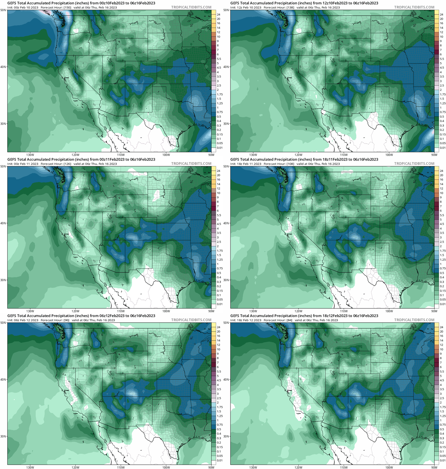
GFS ensemble mean precipitation trend forecast from the last 12 runs. Over time the heaviest precipitation has shifted southward in this modeling suite.
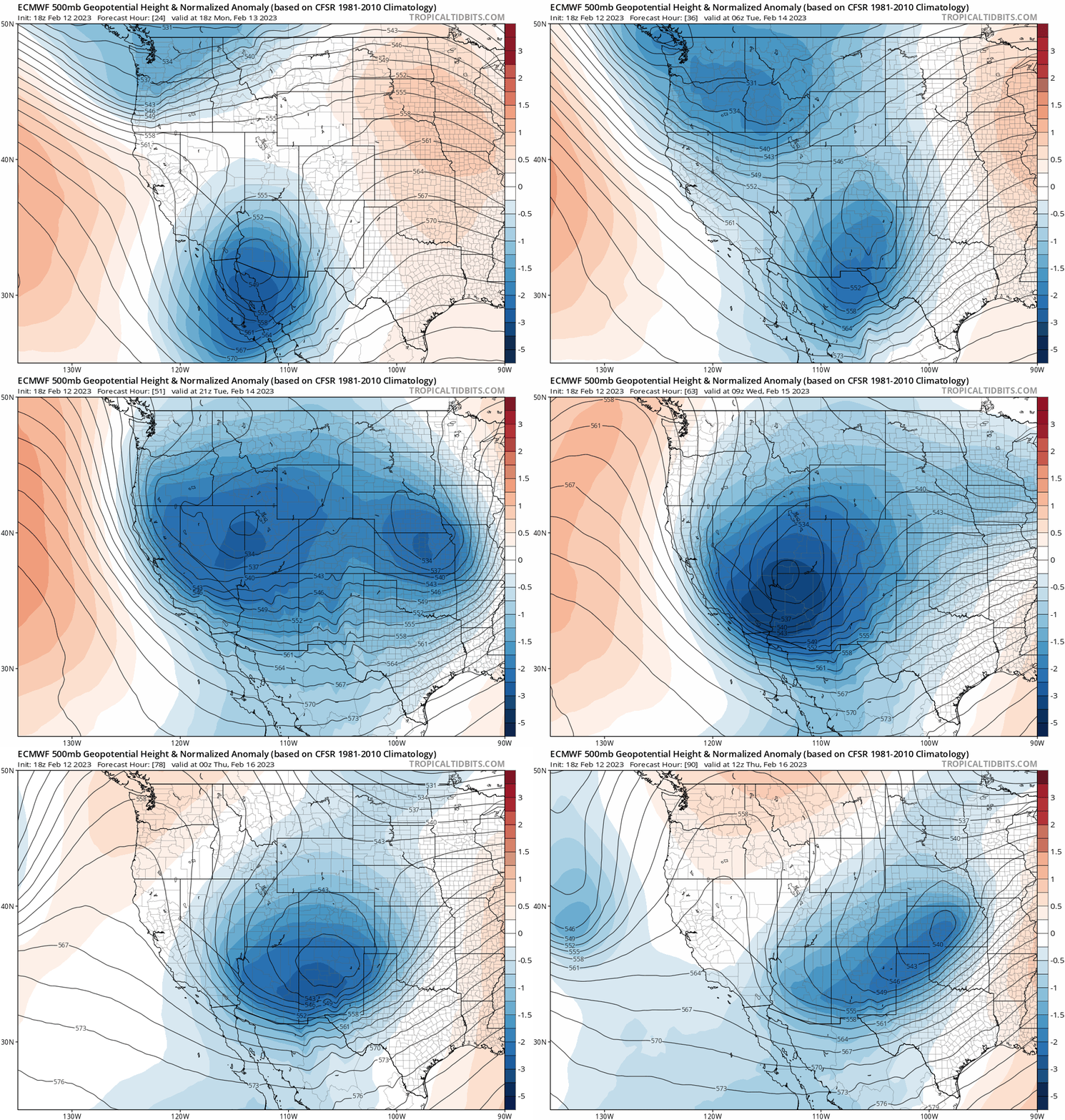
The European model’s 500mb height anomaly forecast below shows our storm — it’s the secondary one that drops from the Great Basin into Arizona and then eastward. Notice how it forms a sizable closed circulation across northern Arizona by Wednesday morning before weakening in New Mexico Wednesday night.
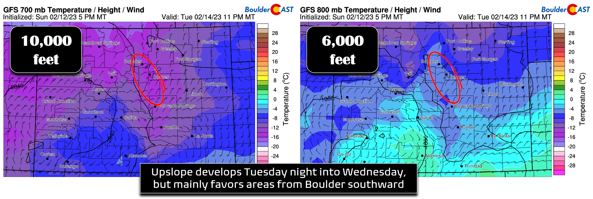
Unfortunately the way this low sets up will not favor extensive upslope across the Front Range, though there will certainly still be a period of easterly(-ish) flow nonetheless as well as weak large-scale lift from the trough. The GFS model forecasted winds and temperatures at ~10,000 and ~6,000 feet elevation are shown below for Tuesday night. With the track of the storm being way down in Arizona, the resulting upslope with mainly be from Boulder southward. Fort Collins and possibly even Longmont will be outside of the snow globe looking in for this event resting too far north. All hope is not lost though — we continue to see strong support in the models for widespread accumulating snow across our area, just less snow than was once advertised. This type of shift is no surprise — and is the main reason you should not put too much stake into snowfall forecasts so far out. The general pattern was recognizable more than a week in advance — but the finer details like snowfall amounts are still being worked out even now.
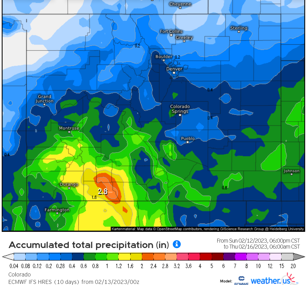
The good news is that models are starting to come into fairly good agreement overall with this event. The precipitation forecast from the Euro model lines up with our expectations that the most snow will fall in the higher terrain south and southwest of the Metro area — this coincides with the region of upslope above. Boulder County being on the far northern fringe of things is a concern — a slight track shift further south could wither away our snowfall chances further. This is something we will be watching closely over the next 24 hours.
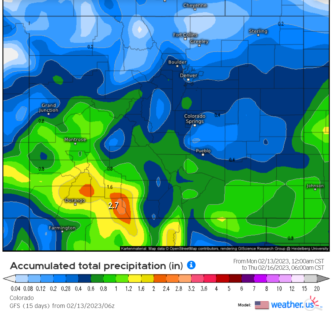
Surprisingly the GFS model is coming in very similar to the Euro in its latest run. Clearly the focus of this midweek storm will be across southwest Colorado which will see feet of snow. There will also be a swath of heavier snow extending out across the Plains. That is most likely to occur down closer to the New Mexico border.
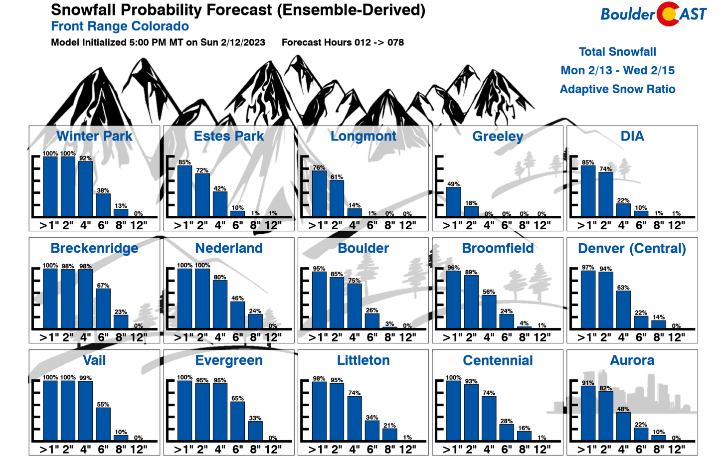
Our latest Snowfall Probabilities point to this being a 2-6″ snowfall event for the Boulder-Denver area, with more like 1-4″ further north and east and 4-8″ in the Foothills. Where does your location fall on the spectrum?
The onset of the snow likely comes sometime Tuesday evening — probably just shortly after sunset for the upslope-favored areas. Light to at times moderate snowfall will continue through Tuesday night and most of Wednesday. Yes this will be a long duration snowfall event — snow may not fully wrap-up until Wednesday evening for the Front Range. This long duration for snow will help secure at least some snow for everyone — though it won’t be coming down in a hurry. The Wednesday morning commute is shaping up to be the most risky at the moment, while Tuesday’s evening commute appears mostly safe for now.
Our preliminary snowfall forecast map for the event is shown below covering all snow falling Tuesday evening through Wednesday night. As we have discussed already, the highest totals will be across the Foothills of Jefferson County and the Palmer Divide. We’re likely to fine-tune this forecast map Tuesday morning so do check back!
In addition to the snow, Wednesday will be bitter cold across the area with highs staying in the teens under overcast skies as light snow continues to fall. Those colder temperatures will mean fluffier snow ratios as well. This event should land somewhere near 15:1 for the area. Blustery winds through the day gusting up to 25 MPH on Wednesday will create wind chills down around zero. Overall, we do not recommend Wednesday!
It’s also worth mentioning that skiers should have a fun time this week — the further south and west you go the better!
Drying out & warming up late week
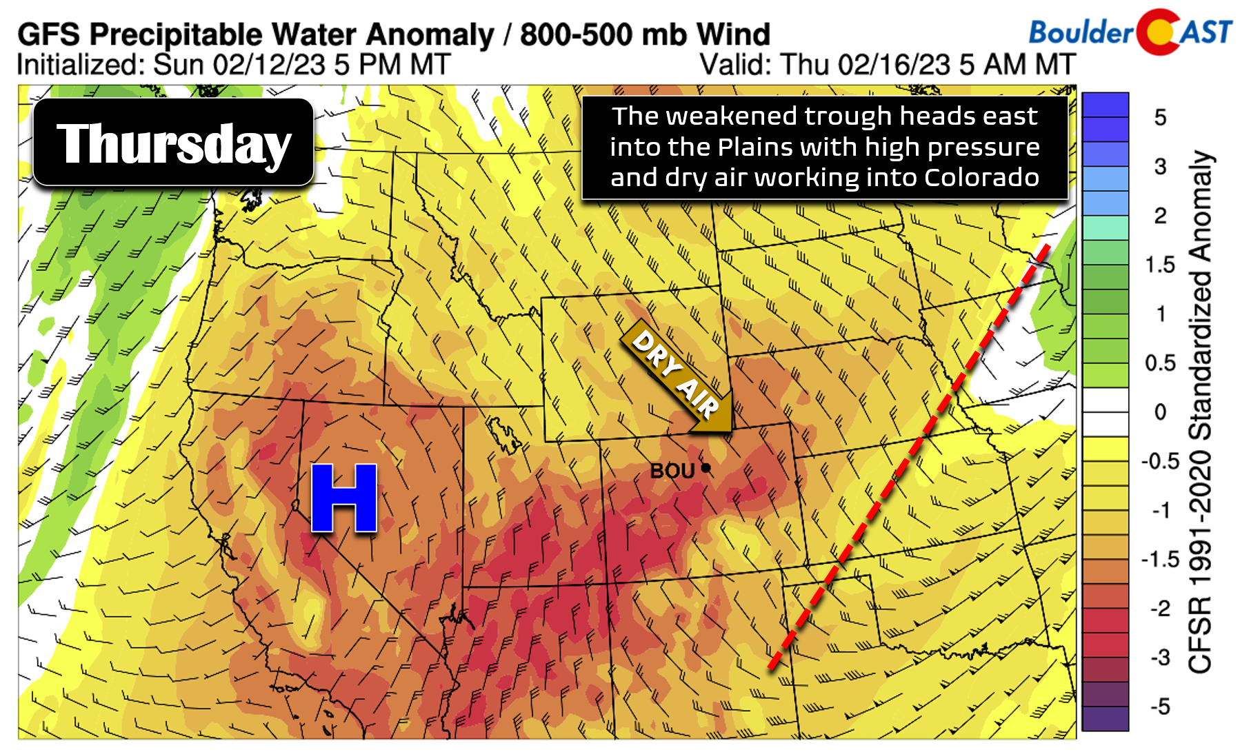
By Wednesday night into Thursday morning, what’s left of the weakened storm will head out into the Great Plains and depart Colorado. In its wake, high pressure and dry air will filter into the Front Range rather quickly from the northwest leading to rapid clearing. Thursday will be beautifully sunny but still cold with fresh snow on the ground everywhere. Despite the sun, highs will only be around the freezing mark on Thursday allowing the feel of winter to accompany the looks.
By Friday, the ridge of high pressure will be directly over Colorado if not just slightly to the east allowing for warm air advection and downslope flow from the west or southwest. This should lead to a nice warm-up to end the week with just a few wave clouds to contend with. Highs return well into the 40s or even the lower 50s by week’s end.
Stay safe, stay warm and enjoy the return of winter to the Front Range this week! We will be putting out a forecast update Tuesday morning so be sure to check back or subscribe to our email list.
Forecast Specifics:
Monday: Increasing late-day clouds and quite mild with highs in the upper 50s to lower 60s on the Plains and in the upper 40s in the Foothills. A very slight chance of rain/snow showers arrives after dark in the evening, but most of us remain dry.
Tuesday: More cloud cover and cooler with temperatures in the 40s on the Plains and in the 30s in the Foothills. Breezy west winds reach 20 MPH by afternoon. Snow should hold off until after sunset, but will become widespread across the area late Tuesday evening into Wednesday.
Wednesday: Blustery with light snow continuing through the day with bitter cold air locked in across the area. Highs stay in the upper teens on the Plains with single digits in the Foothills. Additional snow accumulations through the day should be light with improving road conditions. Snow fully ends by evening.
Thursday: A few lingering morning low clouds possible, then sunny skies. Temperatures remain well below normal with highs close to 30 degrees on the Plains and in the 20s in the Foothills.
Friday: Wave clouds develop through the day but otherwise dry and seasonal. Highs reach the middle 40s on the Plains with middle 30s in the Foothills.
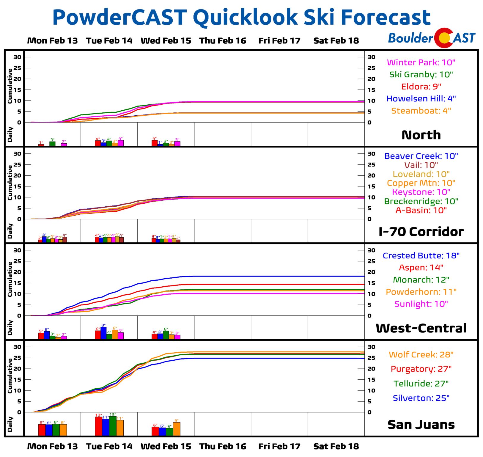
PowderCAST: It will be a busy powder week in the Mountains, especially across southern Colorado which will catch significant snow from both low pressure systems passing through. The northern Mountains will see lower totals of 4-10″, most of which falls Tuesday into Wednesday. The San Juans however stand a good chance to see more than 2 feet of snow in spots.
Help support our team of Front Range weather forecasters by joining BoulderCAST Premium. We talk Boulder and Denver weather every single day. Sign up now to get access to our daily forecast discussion email each morning, complete six-day skiing and hiking forecasts powered by machine learning, first-class access to all our Colorado-centric high-resolution weather graphics, bonus storm updates and much more! Or not, we just appreciate your readership!
Spread the word, share the BoulderCAST forecast!





You must be logged in to post a comment.