For the first time in many years, thundersnow rumbled within the city of Boulder Sunday evening! Snow totals from the storm varied from a dusting up to nearly 12″ across the region. We discuss the evolution of the storm and recap the snowfall totals.
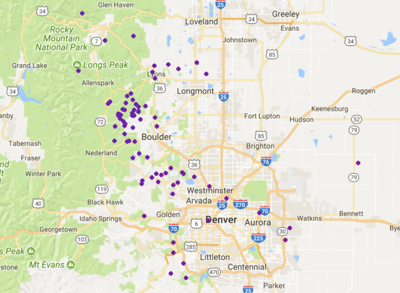
An impressive amount of convection was present in Sunday’s rain-changing-to-snow storm across the Boulder/Denver area! The map below shows all of the lightning strikes observed across the Front Range. There were a couple in Boulder and near downtown Denver. The largest clustering, however, was in the Foothills just a few miles west of Boulder.
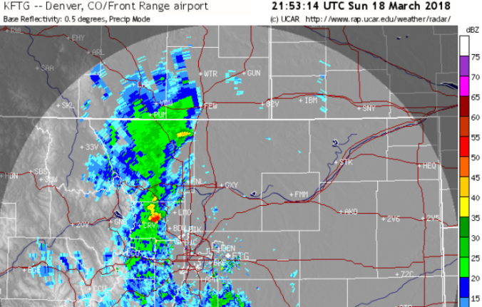
More than two dozen lightning strikes occurred in a two-hour period as a thunder-snowstorm remained stationary near Jamestown late Sunday afternoon. The radar image below shows the storm as of 3:53 PM Sunday. With reflectivity values near 60 dBZ, there was likely nickel sized hail falling alongside the big juicy dendrites. Due to a few hours of 2 to 3″ per hour snowfall rates, Jamestown recorded nearly a foot of snow, just about the largest total reported in the entire state yesterday.
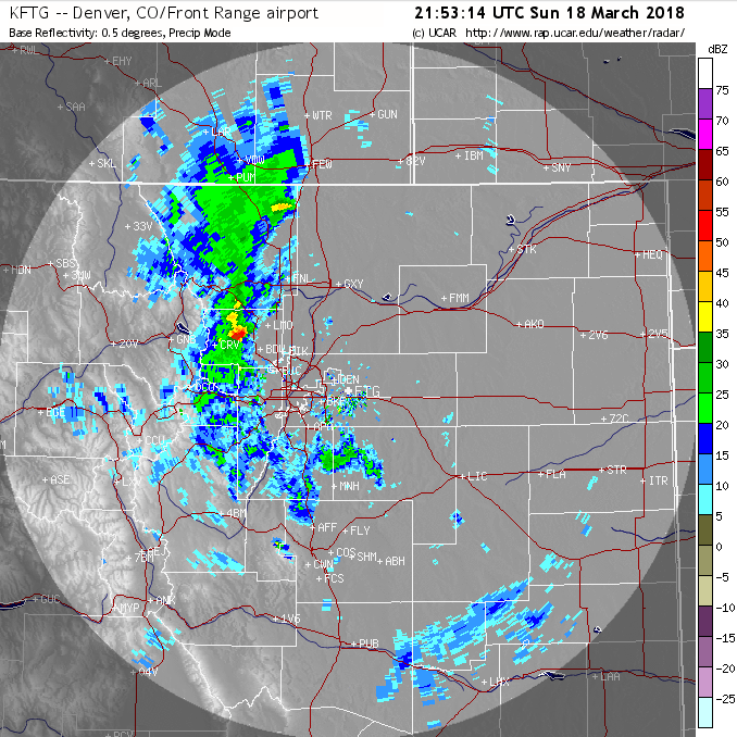
Radar image of the Denver Metro area from 4:00 PM Sunday March 18, 2018. A hail-filled thundersnow event was underway just west of Boulder.
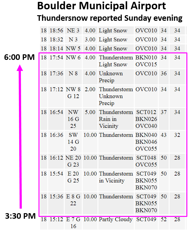
Observations from Boulder Airport show two hours of thunder activity nearby with temperatures falling from 52 degrees to 34 degrees and rain changing to (thunder)snow! The aggregated snowflakes I witnessed during this time were some of the biggest I have seen in Colorado. They were easily between half-dollar and golf ball sized in diameter. Snowflakes this large rarely form, requiring an atmospheric column with near-freezing temperatures and strong vertical motion. The near-freezing temperatures cause the snowflakes to partially melt which allows them to stick together more easily. Similar to hail formation, convective updrafts help suspend the snowflakes while they grow massive in size before falling to the ground.
Hooray! We call all check thundersnow and giant snowflakes off the list of Front Range weather to witness in our lives!
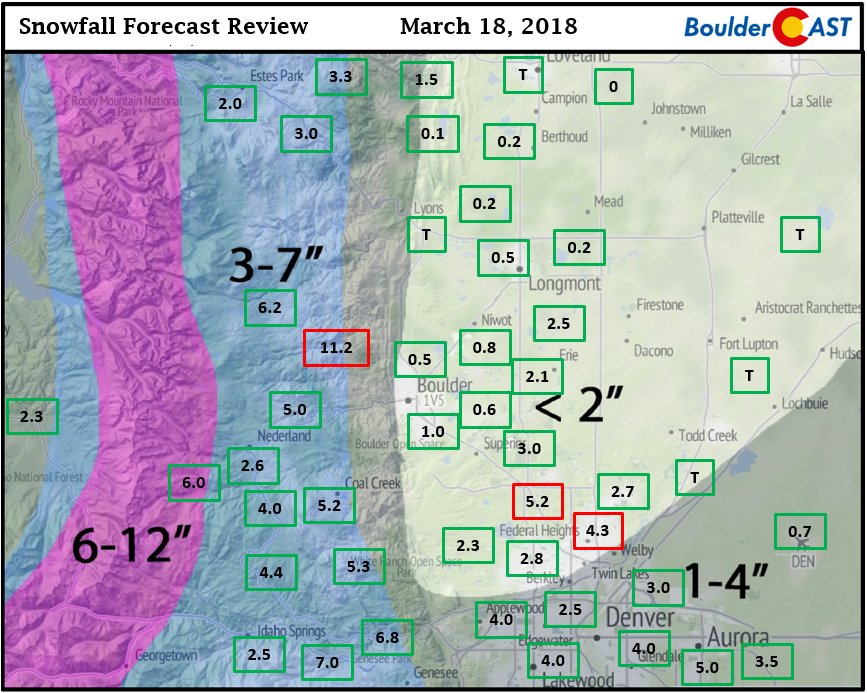
Shown below is our original snowfall forecast map (issued Sunday morning), with the observed storm totals per location contained in boxes. Green ones indicate that the observed snowfall was within one inch of the given forecast range, while red was outside the scope of our forecast.
Despite the large amount of uncertainty in how snow totals would materialize across the Metro area, most locations ended-up within our snowfall forecast ranges. The official report in Boulder was 1.0″, with 0.7″ reported at Denver International Airport.
One wrench in the system was a much earlier than expected change-over to snow in parts of the western and southern suburbs. Models were all indicating rain would turn to snow around 8:00 PM, or even later. In reality, snow was falling in many locations as early as 5:00 or 6:00 PM. The additional cooling must have been provided by dynamic cooling fueled by strong lift, which jives with the more widespread thunderstorm activity. For these reasons, snow totals were near the upper bounds of our forecast for areas around Denver proper, generally 2 to 5″. Travel at times became tricky with several inches of thick slush accumulating on the roadways. BoulderCAST team member Andy reported that his RTD bus got stuck several times near the Park-n-Ride in Broomfield!
On the flip side, as we outlined in our forecast, warmer air resulting from Cheyenne Ridge downsloping allowed rain or a rain/snow mix to linger in the northern part of the Metro area, including Boulder and Longmont. Snow totals in these areas we’re generally a dusting to 1″. Furthermore, the lack of much upslope overall led to good verification of our 3-7″ forecast in the Foothills. Our only true busted forecasts were in and around Broomfield/Westminster where 4 to 5″ of wet snow fell, and in Jamestown thanks to that stationary thunderstorm mentioned earlier. Snowfall wrapped-up around midnight Sunday night..all-in-all only about 6 to 8 hours of precipitation. This speaks to how intense the storm really was.
With drought expanding, the storm also delivered much needed moisture to the region (0.4 to 1.0″ of liquid).
NWS check: The NWS eventually issued a Winter Weather Advisory for both Boulder (busted) and Denver around 7:00 PM Sunday evening. Their forecast of 4-10″ in the Foothills largely verified, though totals were generally on the low-end of their forecast range for the higher elevations.
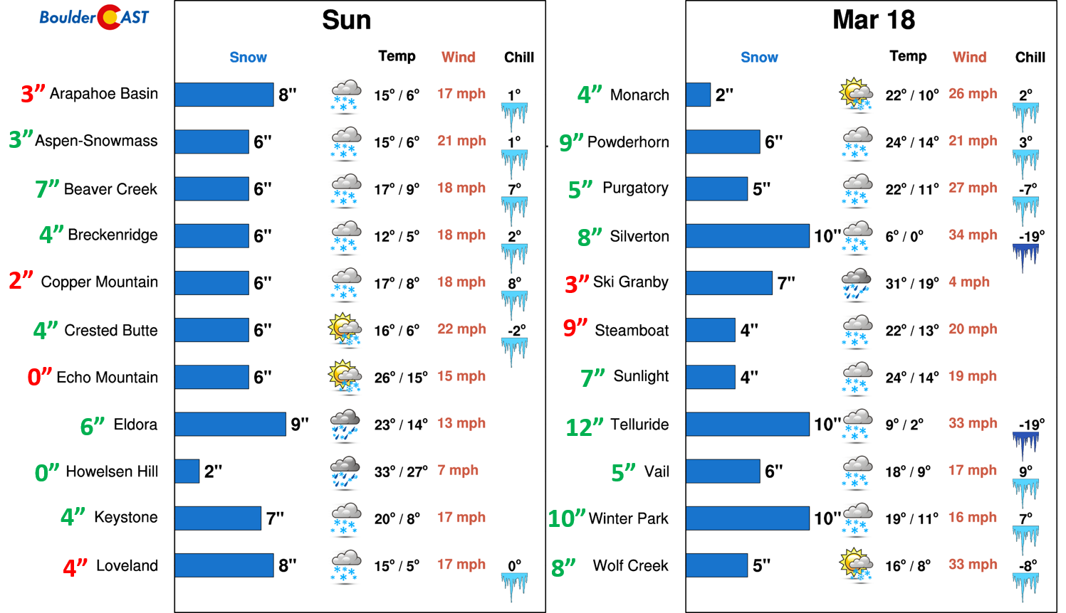
Finally, let’s take a quick look at snow totals from the ski resorts. Our PowderCAST forecast is automated, but it correctly predicted within 3″ of the observed snow total for 16 out of 22 Colorado ski resorts. Actual totals are shown below in large green/red text to the left of the resort names.
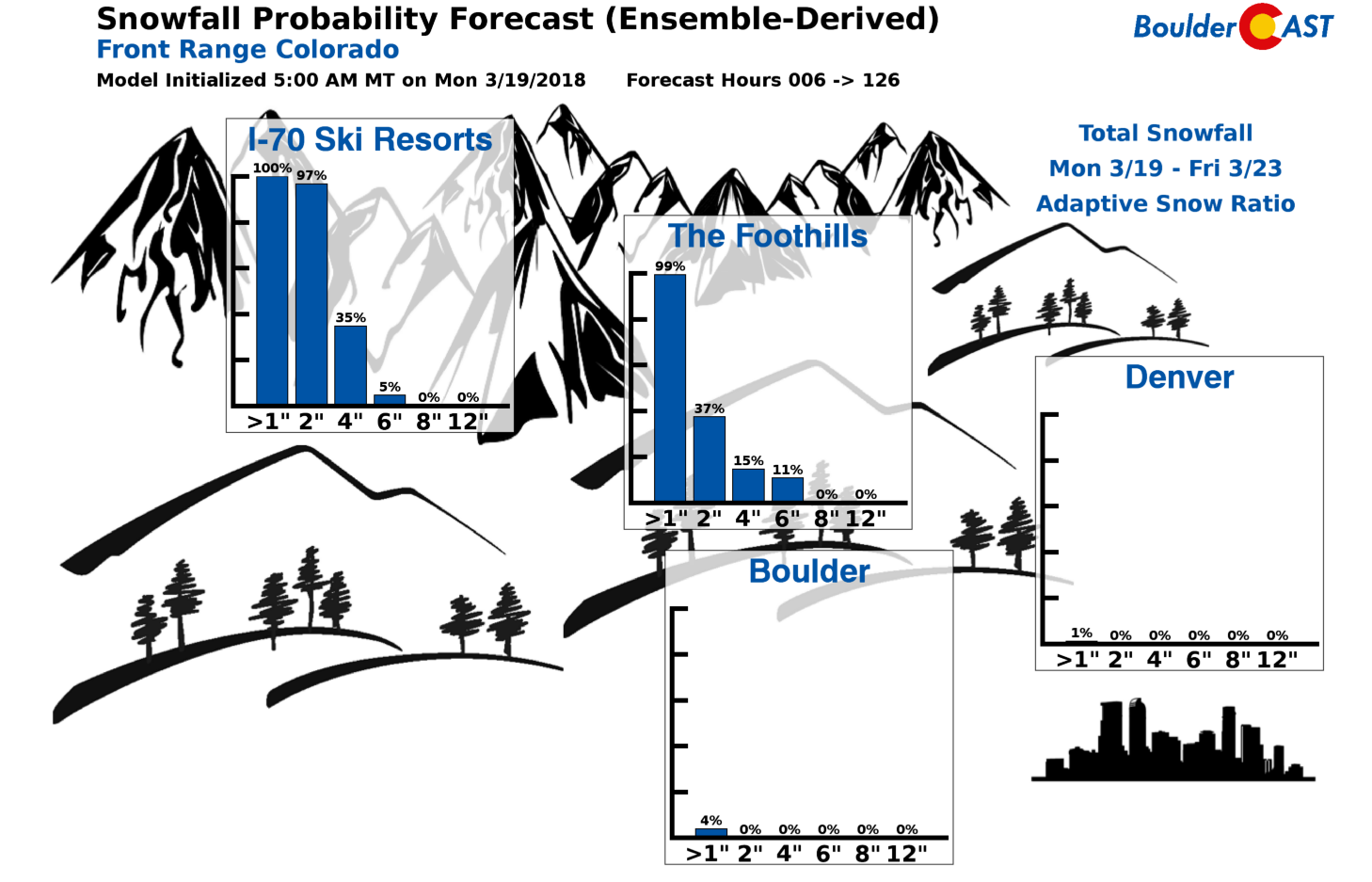
We hope you had a chance to ski that fresh powder Sunday afternoon or today. If you didn’t, don’t worry. Models are indicating another decent dumping of Mountain snow late in the week. This should produce favorable ski conditions for both Friday and Saturday. Nothing wintry is yet on the horizon for the lower elevations…
Share this stormy recap:



You must be logged in to post a comment.