Snow is on the way as a speedy winter storm is set to impact the area Wednesday evening and night. We discuss the tricky set-up that is making for a difficult snow forecast in some areas. Of course, we do give our initial expectations for snowfall amounts as well!
We discuss Boulder and Denver weather every single day on BoulderCAST Premium. Sign up today to get access to our daily forecast discussions every morning, complete six-day skiing and hiking forecasts powered by machine learning, access to all our Front Range specific weather models, additional storm updates and much more!

UPDATE: Just an FYI, we have published a more up-to-date forecast, found HERE.
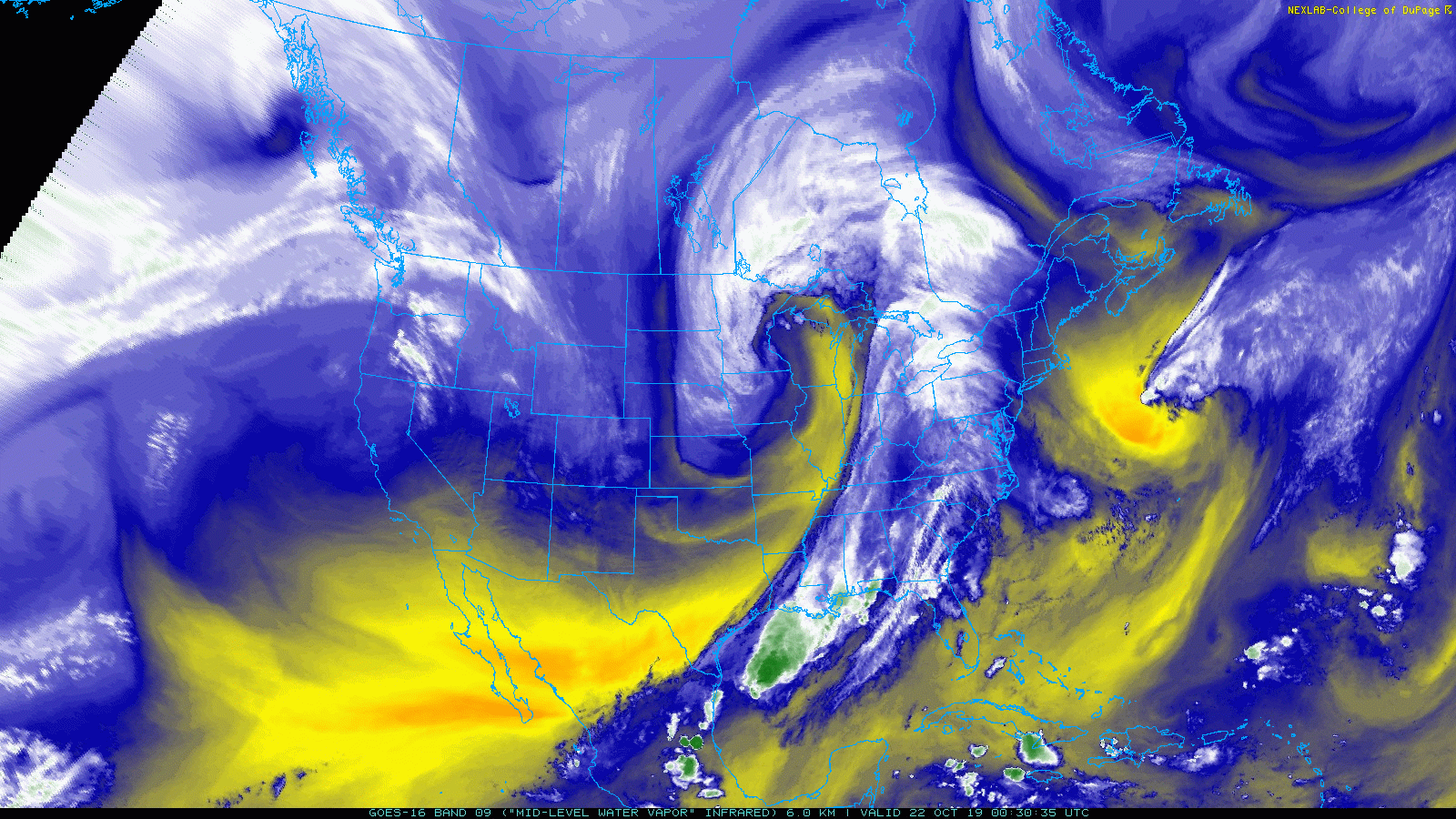
It has been nearly two weeks since our first snowfall of the season, but Mother Nature is right back at it with a quick-moving wintry storm system headed our way. In the current GOES-East water vapor animation below, the storm of focus can be seen as a swirl of clouds coming ashore into British Columbia. If you mind the gusty downslope winds, conditions are rather pleasant across Colorado on this Tuesday afternoon, but this will change quickly tomorrow as the incoming disturbance screams southward out of Canada.
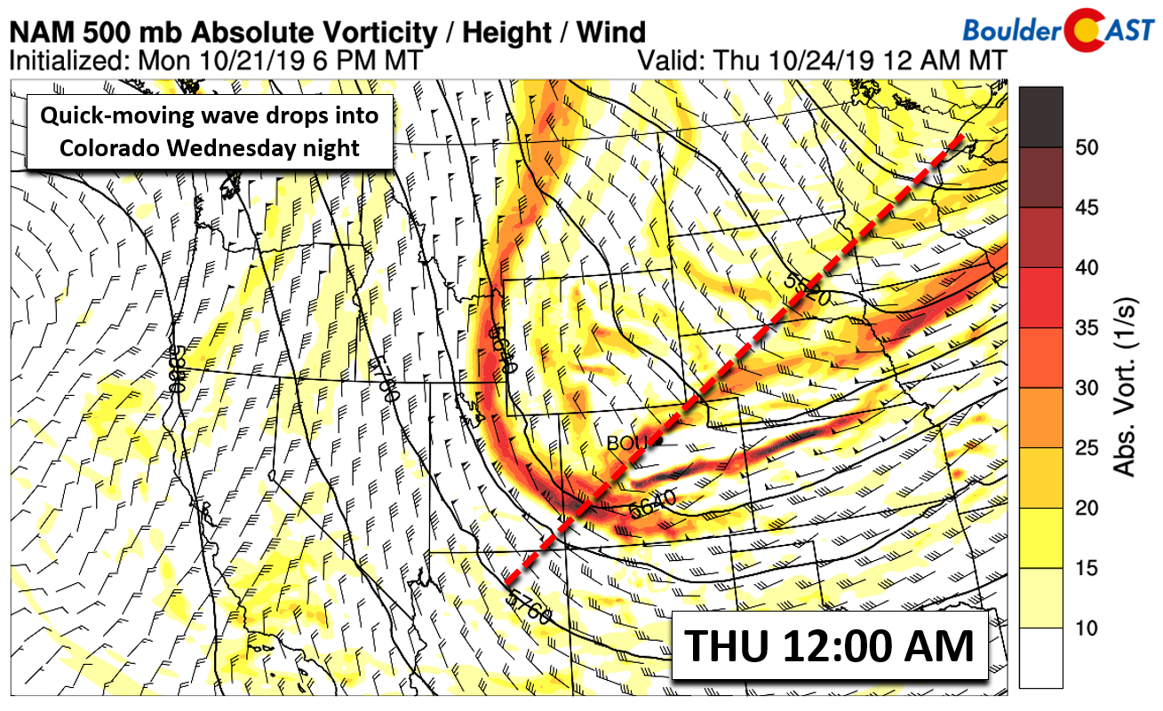
By Wednesday afternoon a cold front will push through the Front Range. This comes after early-day highs in the 50’s. By evening, the associated trough axis will be knocking on the door with a favorable set-up for large-scale lift across most of eastern and southern Colorado.
Despite being just over a day away, models still show considerable and important differences regarding exactly how the trough will pass across the area. The GFS and NAM models are in relatively good agreement of a weaker and progressive open wave system, while the Euro remains an outlier forming a stronger, completely cut-off low pressure near the Four Corners (see below). The European model’s solution allows for the development of stronger counter-clockwise flow and therefore better easterly upslope for all of eastern Colorado. The Euro solution is also a slower one which would favor a slightly longer duration of snowfall as well.
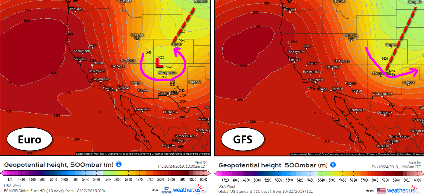
Over the last day or so, we have seen the GFS and NAM trend closer towards the Euro, but they aren’t fully on-board with the optimistically snowy outcome just yet. Thus, while our confidence in the forecast is increasing overall, it’s still going to be a tricky one, especially for the Denver Metro area as the best dynamics are targeting east-central and southeast Colorado, just slightly too far south. For a handful of reasons, we’re likely to see a large gradient in snow totals across our area.
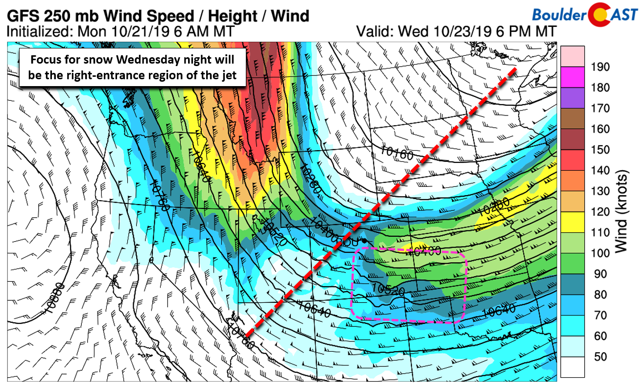
For the first part of the storm, an overhead jet streak will help to enhance snowfall and produce scattered moderate to heavy snow bands in our area. We will be nestled in the right-entrance region of this jet for just a handful of hours beginning around early evening Wednesday. Unfortunately, the onset of these snow bands may conflict with the evening commute in some locations, but just barely. Temperatures should be warm enough that some of this will fall as rain initially or a mix that melts easily on road surfaces.
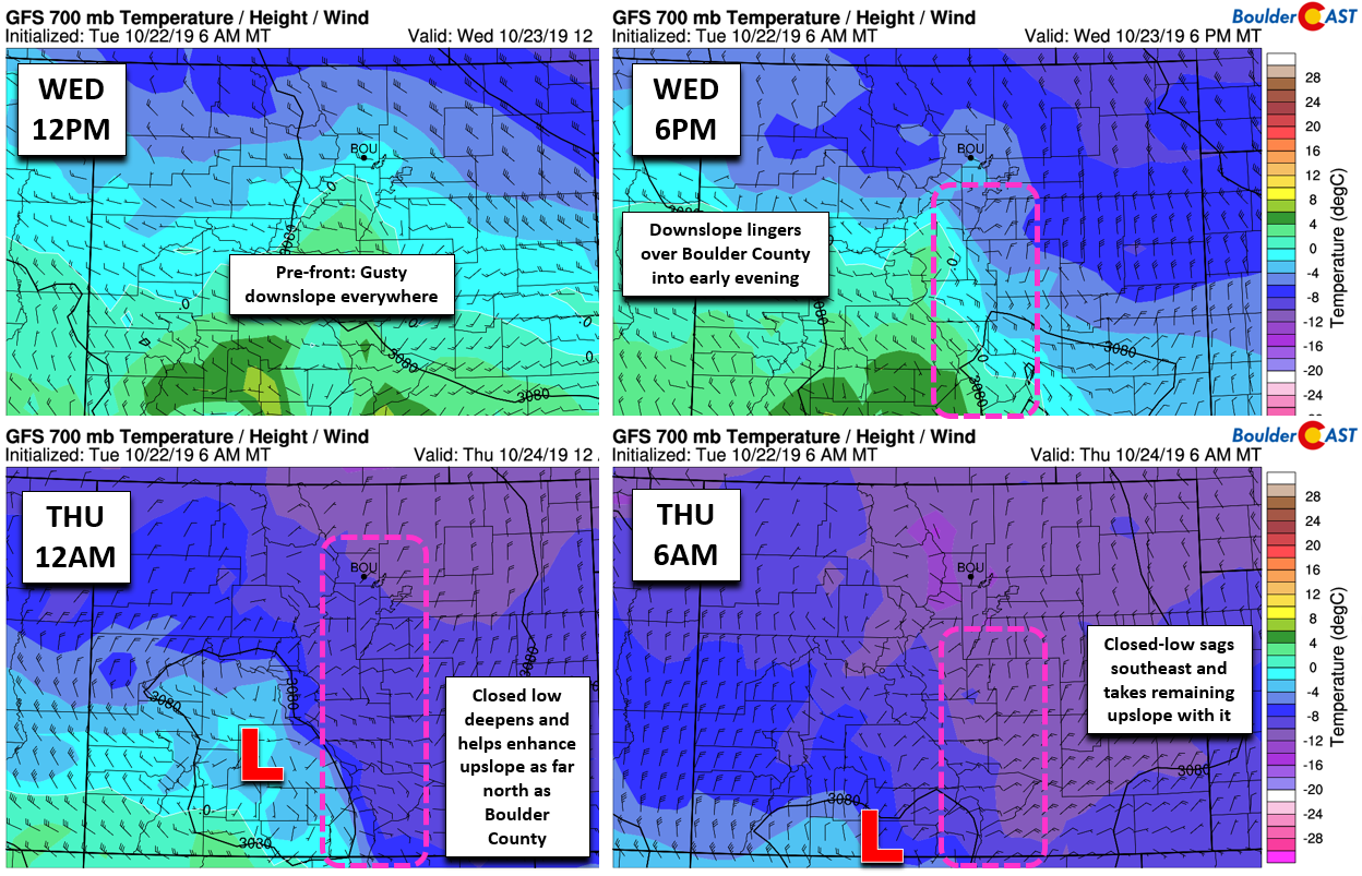
As the night wears on, the aforementioned jet will sag south taking the most dynamic lift with it. Temperatures slowly cool into the mid to upper 20’s with that chance of rain at the onset fully transitioning to snow. Upslope and weaker large-scale lift ahead of the trough will kick-in as the primary forcings for snowfall across the Front Range. If the closed-low solution we mentioned earlier verifies, we’re looking at consistent and fairly deep upslope from Boulder southward throughout a good chunk of the overnight hours. The graphic below shows the evolution of winds and temperatures at 700 mb throughout the event from the GFS model. The pink boxes highlight the easterly upslope winds. Notice how they begin too far south (top right panel), but as the closed-low takes shape overnight, upslope intensifies and spreads back northward to include Boulder as well (bottom left panel).
Further north, upslope will be more limited, actually bordering on non-existent, in areas like Loveland and Fort Collins. These locations will likely be stuck on the “outside-of-the-snow-globe-looking-in” for this snow event.
Our current thoughts are to blend the GFS and European model solutions, factoring in the high-resolution NAM model as well. While we may not see the low fully close-off at the mid-levels, it appears probable (if not likely) that it will at least close-off in the lower atmosphere helping to enhance low-level upslope from Boulder County southward, perhaps up to 700 mb. This will help to boost snowfall rates through the evening and overnight hours, particularly for the southern and southwestern suburbs. The Palmer Divide, JeffCo Foothills, and Pikes Peak area will be the winners with this storm. Travel Wednesday night heading south out of Denver on I-25 or Highway 285 will become treacherous. Elsewhere, the storm won’t be as bad, but still plan ahead for certain snow. If the upslope holds as promised, soundings indicate a good window for dendritic snow growth late Wednesday evening into the early morning hours Thursday. Snow should taper off quickly from north to south within a few hours on either side of Thursday’s sunrise.
Our preliminary forecast snowfall totals for the event are given below.
- Boulder area: 2-5″
- Denver, west and south: 3-7″
- Denver, north and east, including DIA: 1-3″
- Loveland, Greeley, Ft. Collins: Trace-2″
- Foothills and Mountains: 4-10″, highest south
We’re not quite ready to give our “stamp of approval” for an official snowfall forecast map; there is just too much uncertainty in key aspects of the storm system right now. We’ll continue to monitor the situation and provide an update early Wednesday, including our snowfall forecast map. Stay tuned!
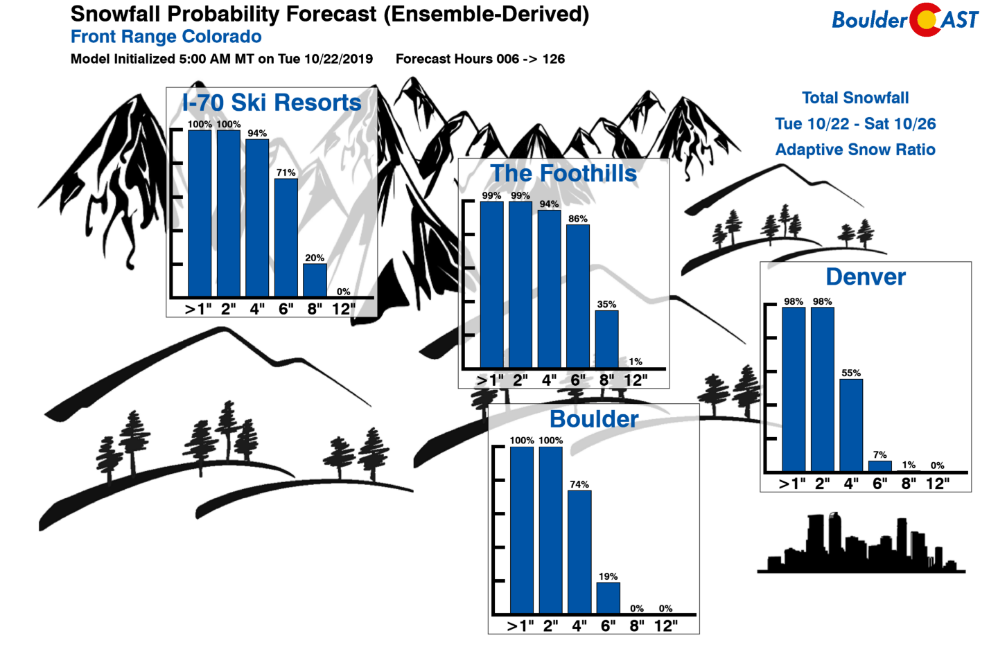
BoulderCAST Snowfall Probability Charts for the event
We discuss Boulder and Denver weather every single day on BoulderCAST Premium. Sign up today to get access to our daily forecast discussions every morning, complete six-day skiing and hiking forecasts powered by machine learning, access to all our Front Range specific weather models, additional storm updates and much more!
.
Spread the word, share the BoulderCAST snow forecast!


You must be logged in to post a comment.