After several dry summers in a row, the 2022 monsoon season has been a breath of fresh air for most of the Front Range, thanks mainly to the recent soggy weather culminating in localized flash flooding earlier this week. As monsoon season begins to wind down across Colorado, we discuss the recent and seasonal rainfall totals, why this year’s monsoon has been atypical, and how climate change may impact future monsoons.
We discuss Boulder and Denver weather every single day on BoulderCAST Premium. Sign up today to get access to our daily forecast discussions every morning, complete six-day skiing and hiking forecasts powered by machine learning, access to all our Front Range specific weather models (including smoke forecasts), additional storm updates and much more!
The 2022 Monsoon has delivered!
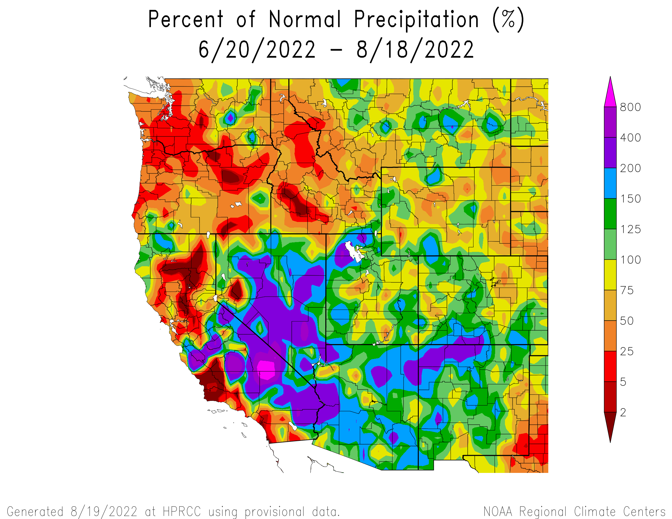
In our last monsoon update at the beginning of August, we discussed how the dry summer pattern in Colorado was finally starting to show signs of change. Since then, Mother Nature has really turned up the dial on monsoon season across the Desert Southwest and in the Front Range. The graphic below shows percent of normal precipitation over the last two months. The Southwest has clearly been under-the-gun from an intense monsoon.
We’ve seen historic, unprecedented flooding unfold in Death Valley with the area receiving a year’s worth of rain in just a couple hours. This is the view from the National Park’s visitor center:
This is indeed a Death Valley. Floods everywhere 🤦🏾♂️🤦🏾♂️🤦🏾♂️ pic.twitter.com/TPvHa50pCm
— Vince (@vincekakooza) August 6, 2022
On two occasions, heavy rainfall in Las Vegas caused urban flooding, including water damage to some of the city’s iconic casinos:
Las Vegas Thursday; wettest monsoon season in decade causes heavy rainfall that hit the city & flood casinos and hotels’ parking lots.
Water crashed through the ceilings of some of Las Vegas’s famous casinos as torrential rain flooded the sites for the second time in few weeks. pic.twitter.com/acnhHUYnsZ
— @KassMedefer (@KMedefer) August 12, 2022
Here in the Denver area, monsoon-fueled thunderstorms produced flash flooding earlier this week on Monday and Tuesday in parts of Broomfield and Aurora.
Watching for flooding in this area where 1 to 2" of rain has fallen in the last 45 minutes #cowx pic.twitter.com/wEbPMDytSF
— BoulderCAST Weather (@BoulderCAST) August 16, 2022
Colorado is not done with the flooding, unfortunately.
A pocket of heavy rain caused flooding on the roads in Broomfield, CO this morning.#COwx #flood #monsoon pic.twitter.com/0WZ4u6MRsO
— WeatherNation (@WeatherNation) August 16, 2022
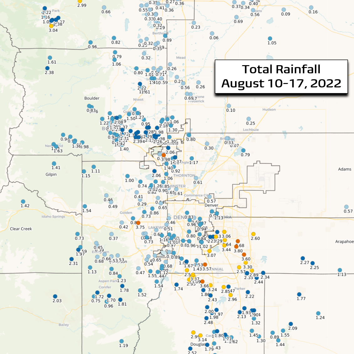
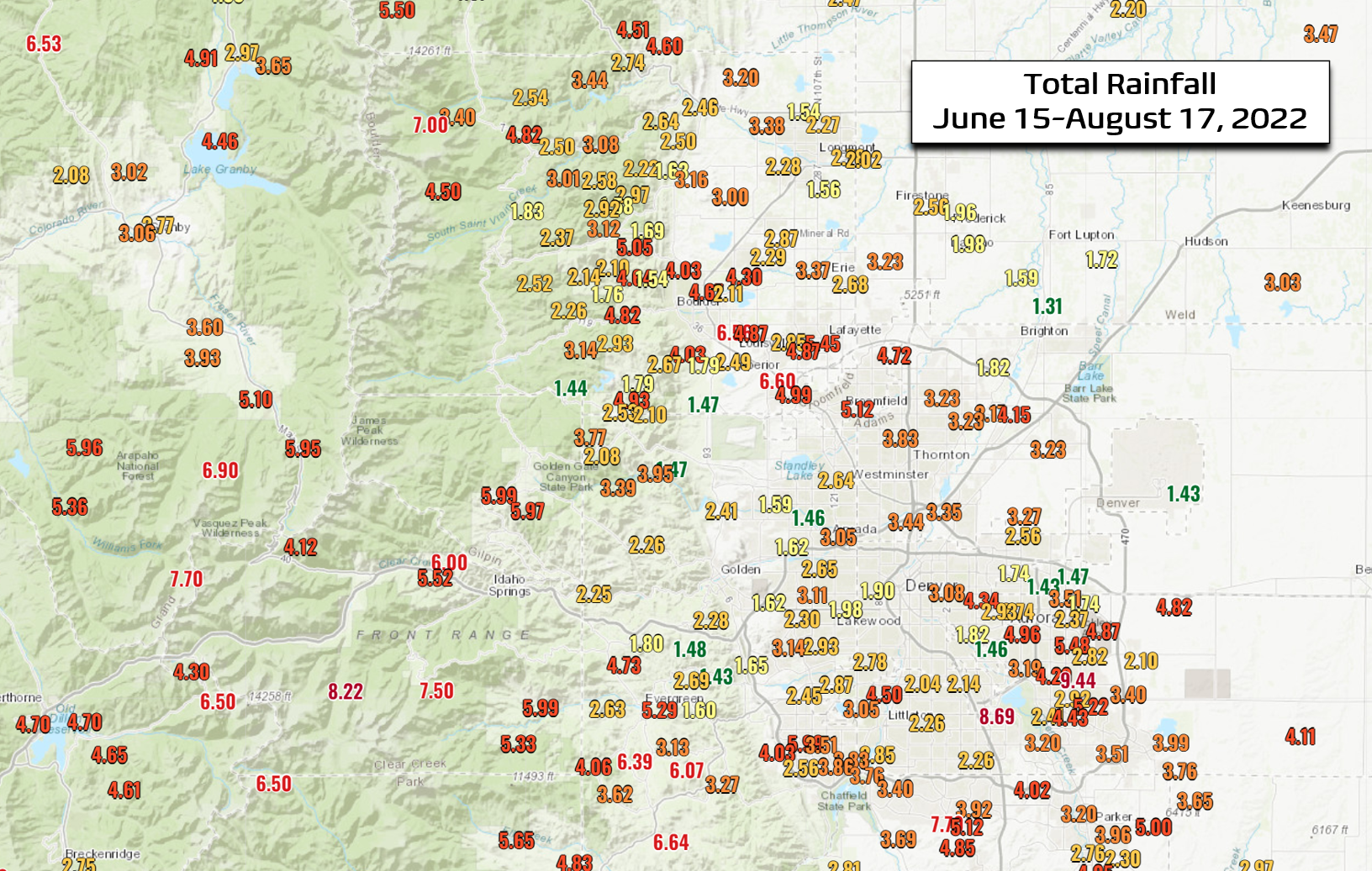
This week certainly was one of our wetter ones in recent memory. Much of the Denver Metro area picked up more than 1″ of rainfall, with the hardest hit locations seeing more than 3.5″! For perspective, that equates to about 20% of the annual precipitation budget for these areas!
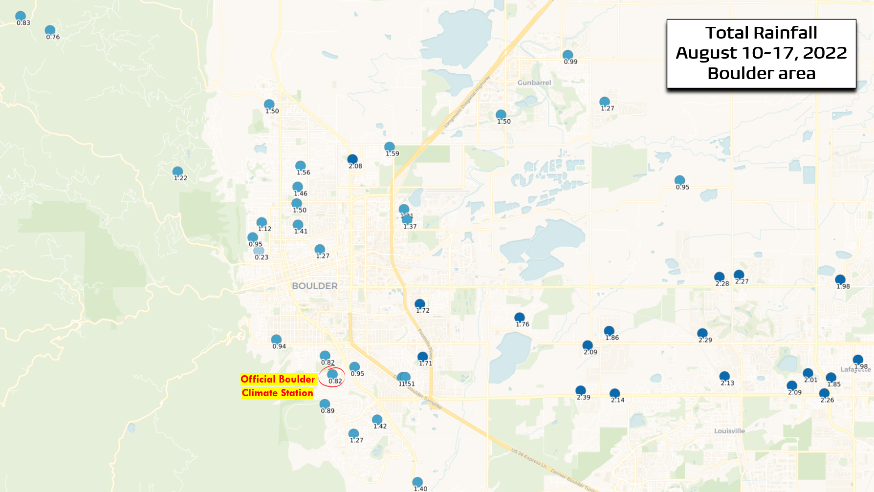
Boulder didn’t quite see that much rainfall, but the moisture dump didn’t spare the area either. The city officially reported 0.82″ of rain this week, but some sectors around town got closer to 2″.
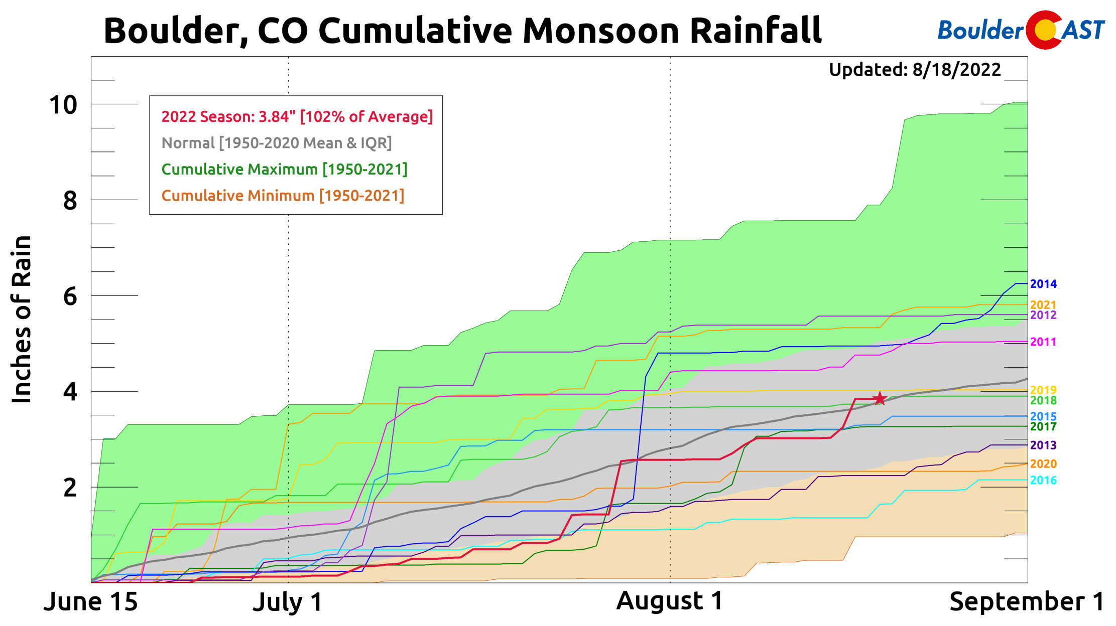
After a lackluster beginning to monsoon season in the Front Range, things started to pick up in late July and that has only continued during the month of August. With the recent rains, Boulder has now pushed above normal for the 2022 monsoon season at 3.84″ — 102% of average as of August 18th. It has no doubt been a capricious season thus far (see the red line below), but things are starting to green up a little out there!
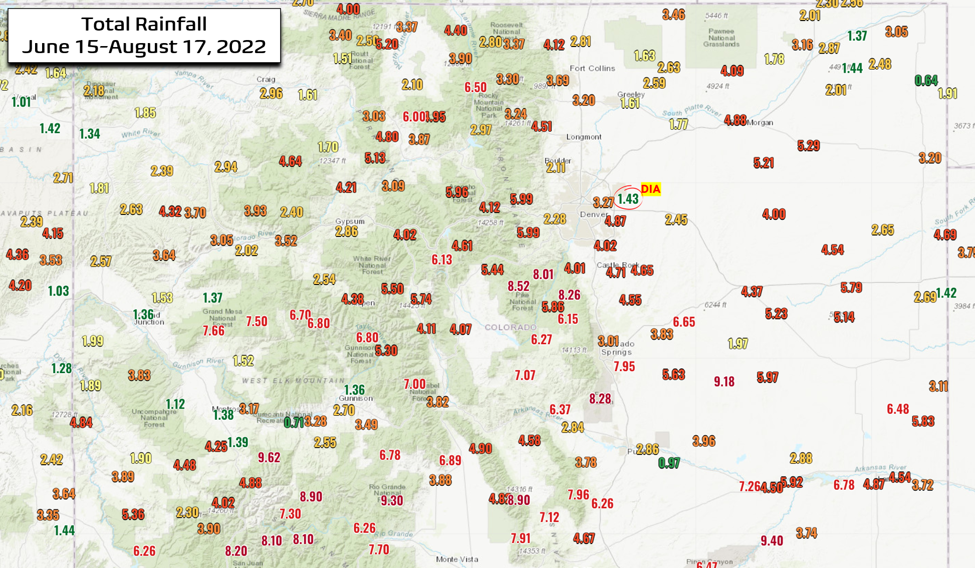
Looking more broadly across the region, it’s clear that not everyone has benefitted from the monsoon equally. Some areas have received more than 6″ of rain this summer — much of that falling in the last two to four weeks. On the other end of the spectrum, a few spots have seen only 1.5″ of rain or even less. Denver International Airport, for example, has recorded a meager 1.43″ in the 2022 monsoon season. The sporadic nature of the rainfall this week and all summer is very typical— monsoon thunderstorms often develop with brutal discrimination. The disparity tends to mostly even itself out over the course of the summer — but that’s not always the case.
Denver’s 1.43″ is one of the lowest rainfall amounts observed in all of Colorado this summer! Only a few select locations like Grand Junction, Montrose, and Holyoke have received less than Denver’s official yet poorly-located climate station!
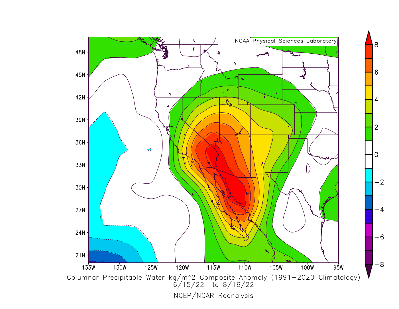
The American Southwest Monsoon has been particularly active all summer long, including an unusually strong westward and northward extension of the subtropical moisture plume a times. The graphic below shows a composite of atmospheric moisture anomalies during the 2022 monsoon season so far. Look at that huge elongated bullseye pushing into Arizona, California and Nevada. The more prevalent push of moisture to the west is the reason the best rains were kept away from Front Range Colorado during June and most of July.
The monsoon on occasion has surged all the way into the Pacific Northwest this summer, something that is fairly rare. Rainy Seattle is usually drier than Phoenix in July and August! Ironically it’s those very same monsoon-enhanced thunderstorms and their lightning bolts that spawned a bulk of the large wildfires currently burning across the Pacific Northwest — those fires which are supplying lofted smoke to the Denver area today!
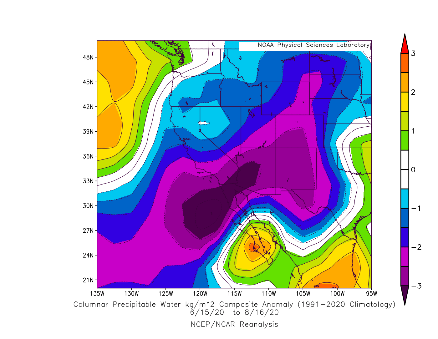
Of course, the monsoon is not nearly this active every year. Just two years ago was one of the most dismal monsoon seasons of the last decade across the southwestern United States and for the Front Range. 2020’s moisture anomaly graphic shows a world of difference compared with the one for this year!
The American Southwest is one of the few places in the United States projected to see declining precipitation in a warming climate. However, much of that decrease is tied to a shifting winter storm track. The impact of climate change on the summer-time monsoon is less understood with conflicting research results. Some studies suggest the monsoon will intensify while others point towards an overall weakening. The nebulous outlook is not surprising considering that thunderstorms and convective processes make up the foundation of the monsoon, facets which are particularly under-developed in current climate models. Thus, the monsoonal outlook for the decades to come in the Southwest is still an open question.
The 2022 Monsoon is coming to an end…
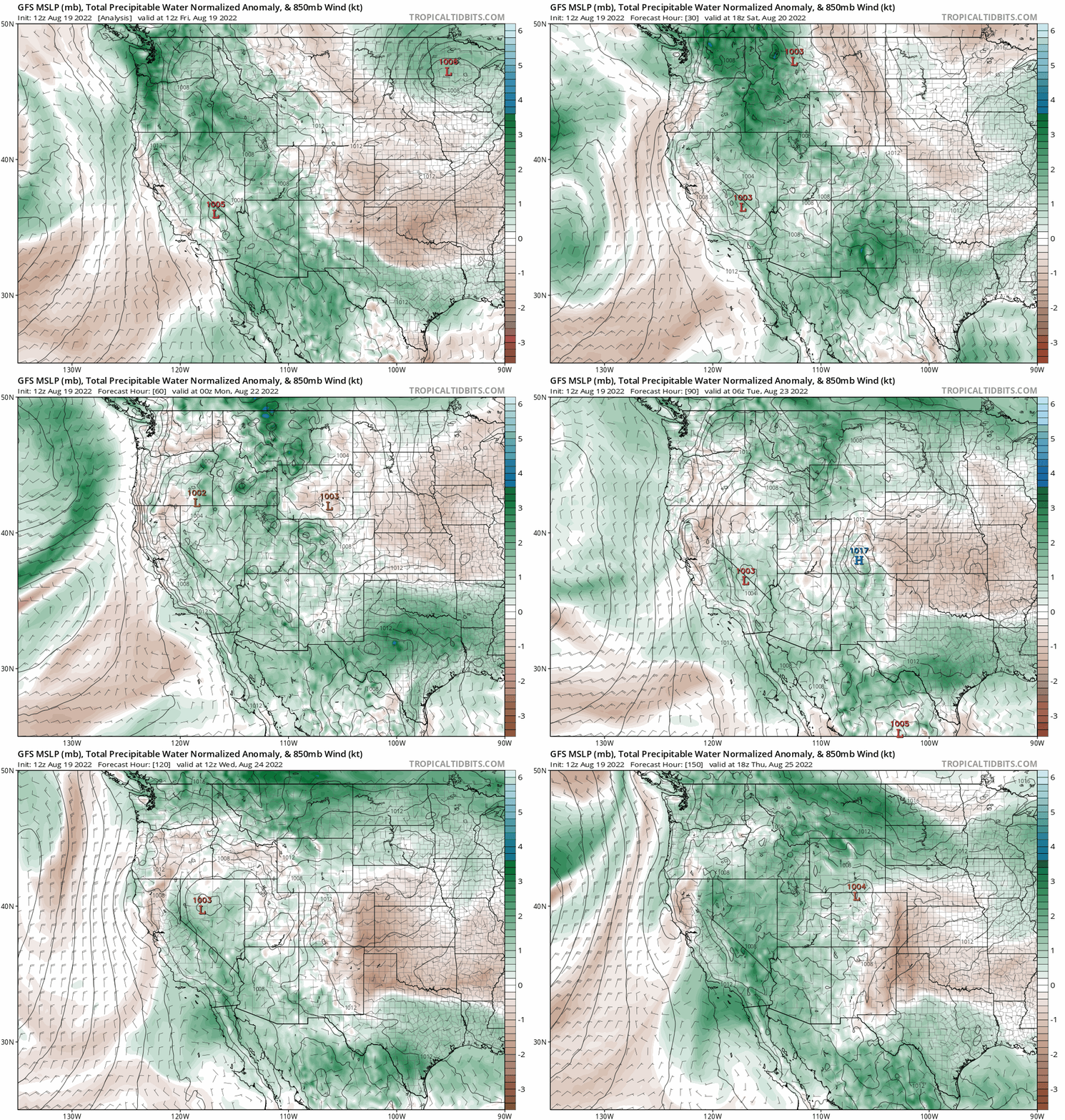
The next week or so doesn’t look all that exciting for northeast Colorado as monsoon moisture largely remains confined to our south and/or west. Sure, there will be a chance of storms some of the days ahead, but nothing looks too widespread or intense. Most of the Front Range will likely be fairly dry heading through at least the middle of next week with temperatures staying near or even below normal. Woohoo!
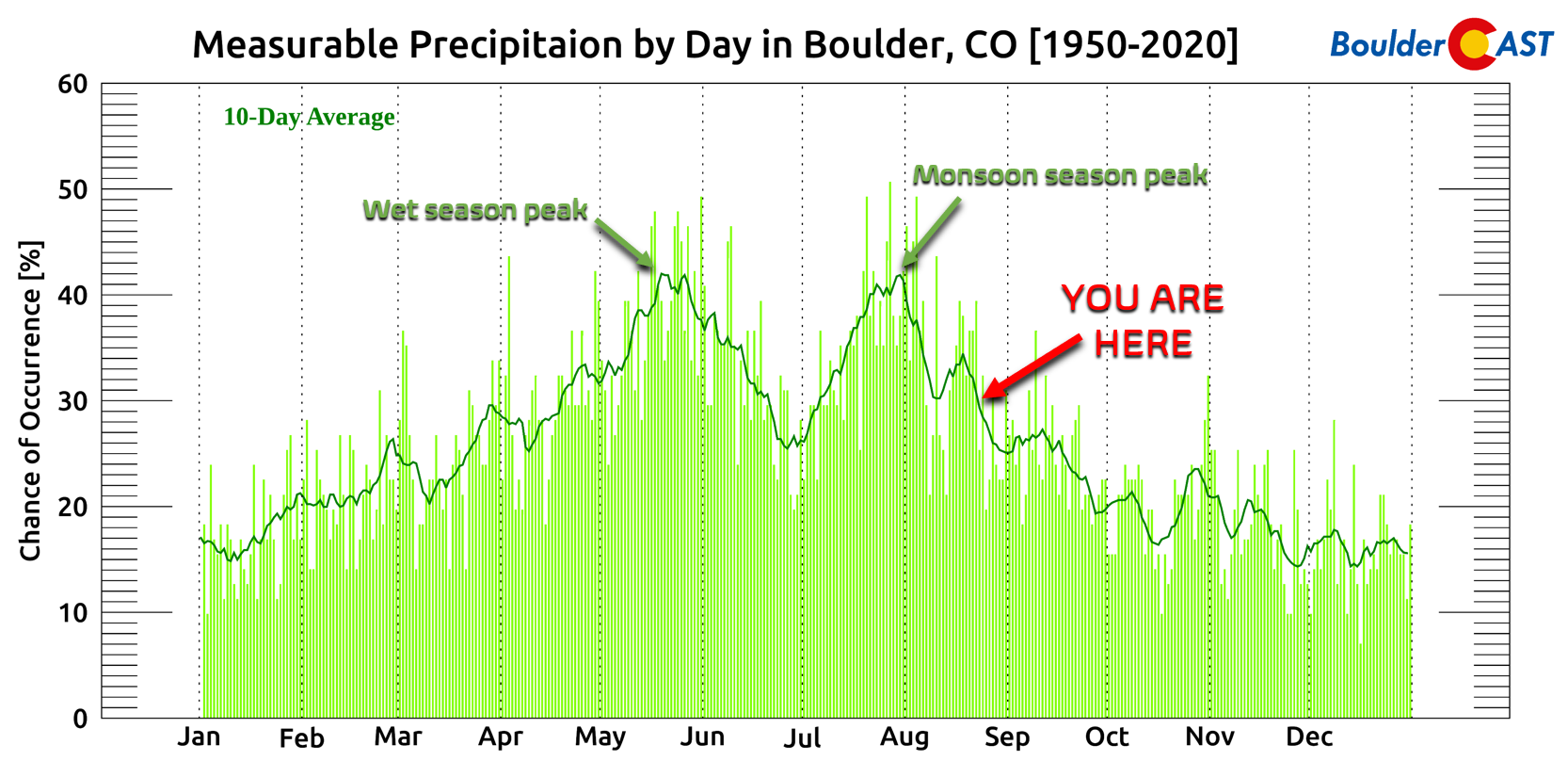
As we head towards the homestretch of August, monsoon season will wind down in Colorado — though it often remains active in the Deserts for a few additional weeks. With this seasonal transition away from the monsoon, our focus will begin to gaze northward, instead of to the southwest, as mid-latitude low pressure systems dropping out of Canada become the primary weather-maker for our area September and beyond…
Finally, now through the end of August use promo code MONSOON to save 25% on BoulderCAST Premium. Sign up HERE!
Get BoulderCAST updates delivered to your inbox:
Enjoy our content? Give it a share!




You must be logged in to post a comment.