After a rather quiet month of December, our first “major” snow event in four weeks is taking shape for late Friday night into early Saturday. The bulk of the snow will bypass the Denver area, but we’re still looking at some accumulation. Read on for details on the falling temperatures, when the snowfall will begin and end, and how much white stuff to expect.
FORECAST UPDATE (Friday Dec 27 3:00 PM): Models are still having trouble with this storm, and so are we. Read our latest forecast and get our latest snowfall forecast map.
LIMITED TIME OFFER: Use the promo code HAPPYHOLIDAYS to save 33% on BoulderCAST Premium.
We discuss Boulder and Denver weather every single day on BoulderCAST Premium. Sign up today to get access to our daily forecast discussions every morning, complete six-day skiing and hiking forecasts powered by machine learning, access to all our Front Range specific weather models, additional storm updates and much more!
W
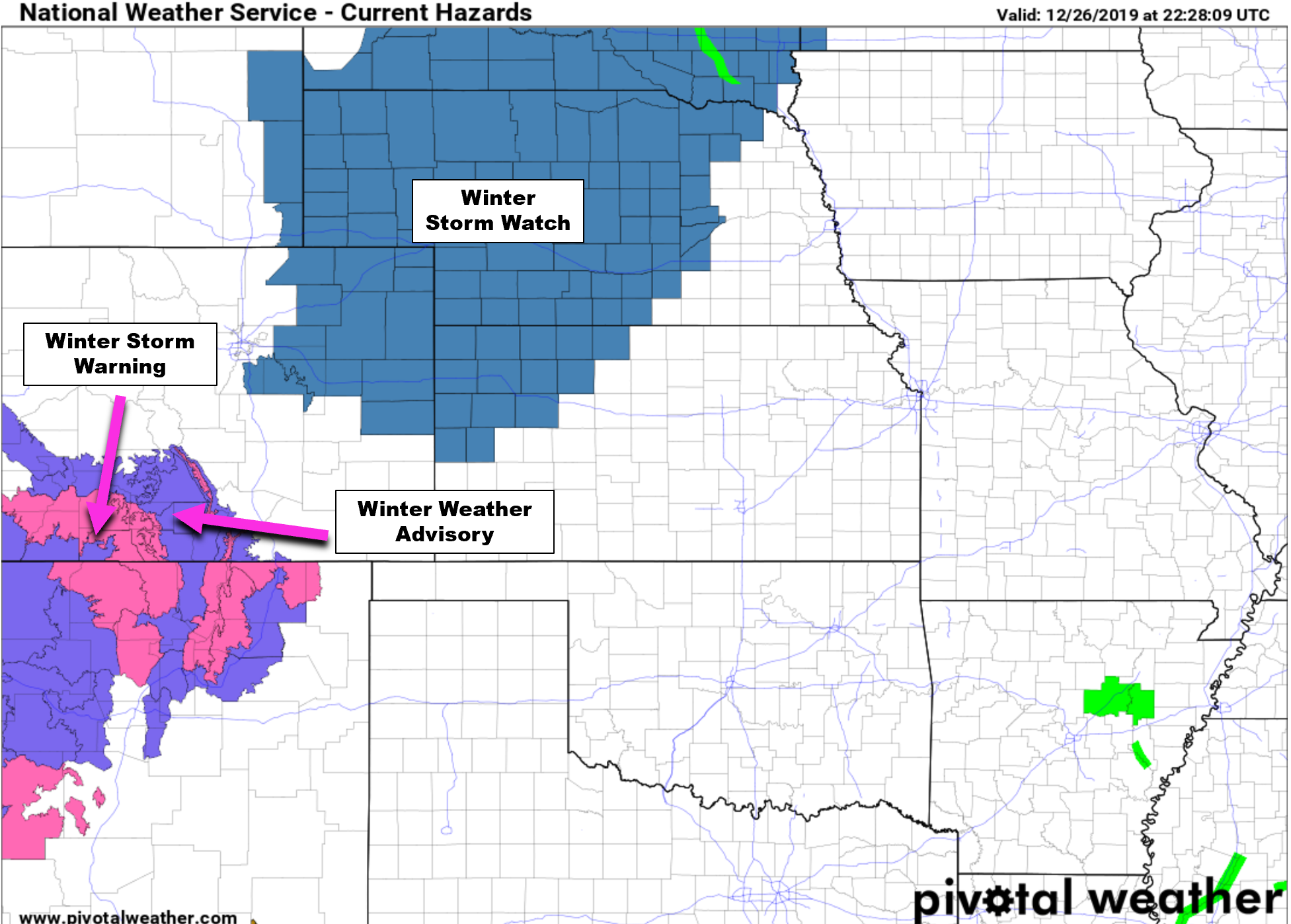
e’ll keep this forecast update (relatively) short, not only because of the holiday, but also our belief that the incoming winter storm will largely be a “swing and a miss” for the immediate Denver Metro area. This is particularly true for the northwest Metro area where downslope will be a factor. More on this in a moment. As it stands Thursday afternoon, the National Weather Service has issued Winter Storm Watches for most of northeast Colorado. This does NOT include Boulder or Denver!
We’ve been discussing the large-scale set-up and developing wintry impacts for the Front Range with our Premium members for the last several days as this complicated forecast has continued to evolve. In our weekly outlook on Monday, we gave you the heads-up about this storm and the potential for heavy snow, but also set expectations for this system as we believed it would track too far south and east to bring much to the Denver/Boulder area. This remains a center-piece of our mindset today with everything seemingly not coming together until after it will have already passed the Metro area.
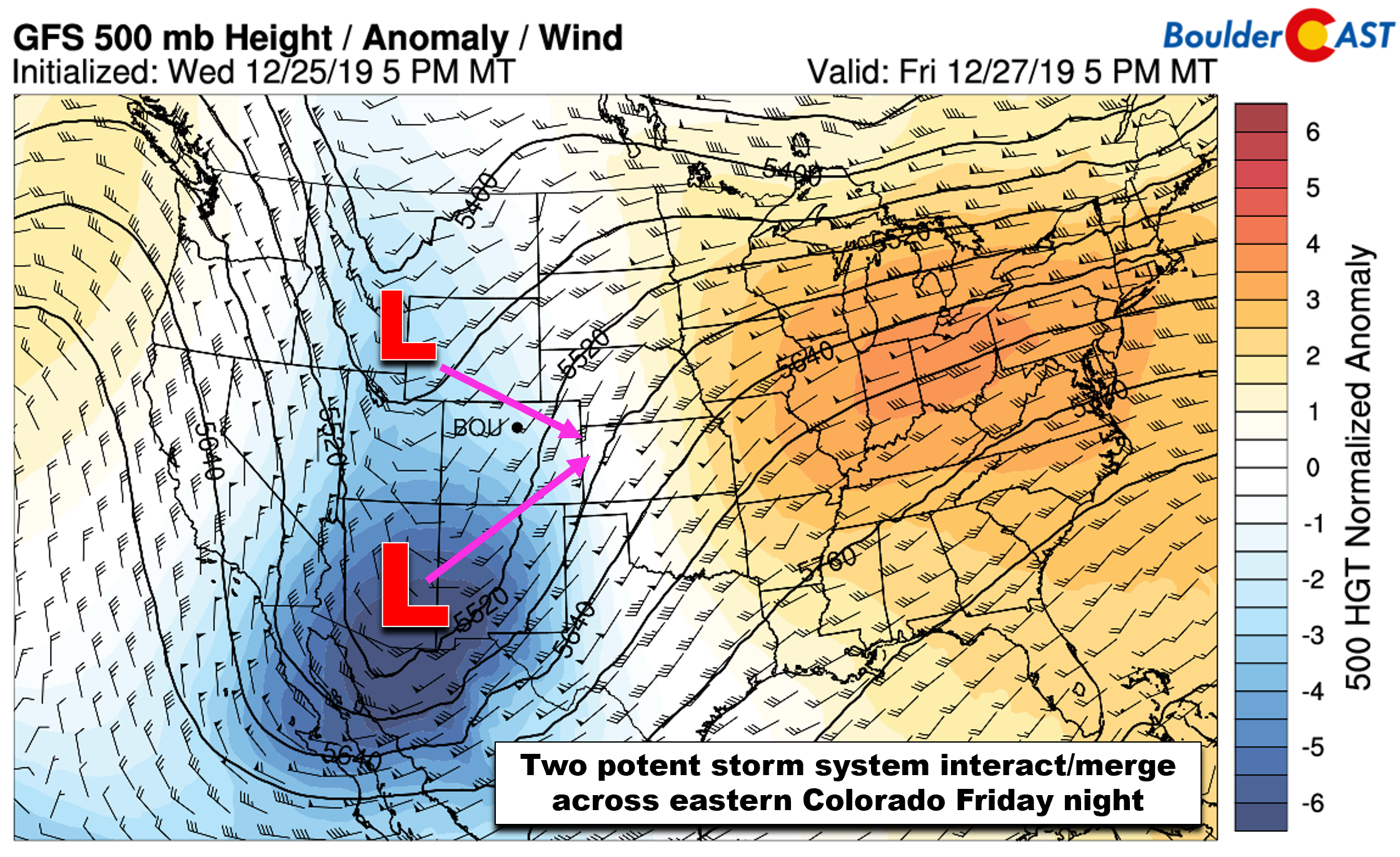
The large-scale players this time around consist of two potent systems with differing origins that will more-or-less merge over eastern Colorado or western Kansas Friday night into early Saturday:
- The first player is a slow-moving cut-off low pressure system sliding northeastward from extreme southern Arizona. This low was the spawn of a very disorganized and sluggish trough that has been holding across the West Coast since Sunday. It is expected to track into southeast Colorado in the next 24 to 36 hours.
- The second player is a strong but small shortwave dropping almost due south out of western Canada. This system has colder air and is moving faster than the other.
These two systems will essentially merge just east of Denver Friday night (see animation below), combining their energy into a strong winter storm that will then push into the Great Lakes as the weekend progresses.
The forecast itself is challenging due to the fact that the two storm systems are merging, but also because one of them is a cut-off low. Weather models notoriously struggle with both of these scenarios. Because we are dealing with both here, uncertainty in the snow potential is higher than normal. Lucky for us, right?!
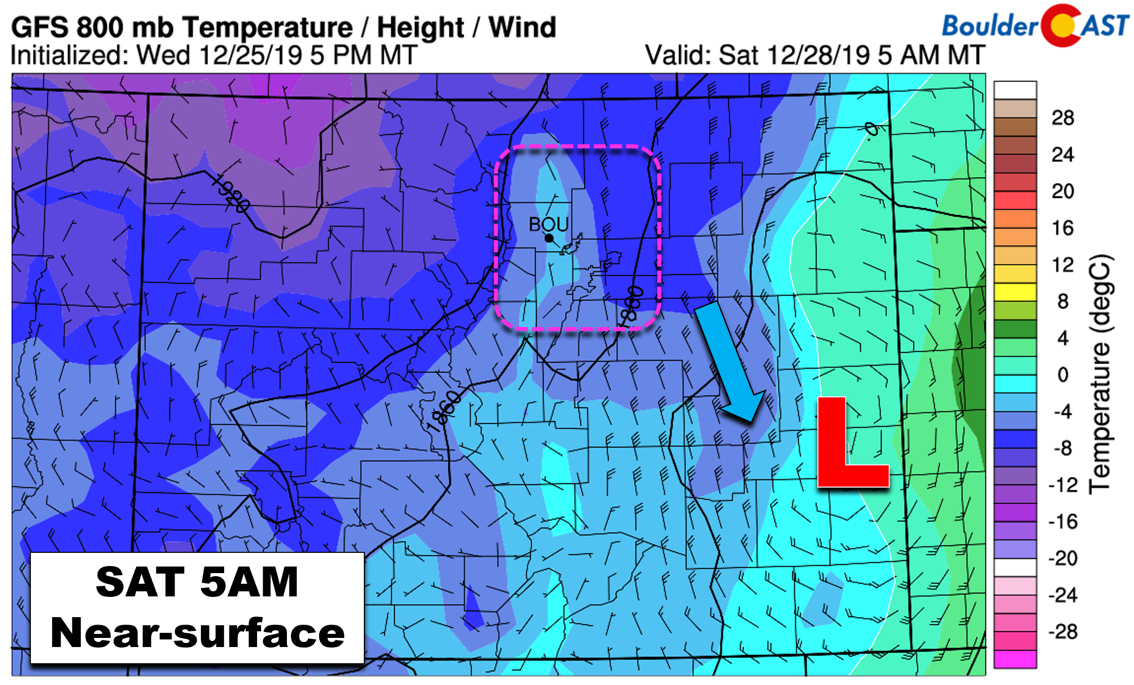
In any case, the ingredients for snowfall will start to come together across eastern Colorado Friday evening (decent moisture, mid-level lift, the overhead jet, cold air). A rapidly developing surface low in southeast Colorado will begin to intensify and draw cold air southward due to the pressure drop at the surface Friday evening. The two panels below show near-surface height (pressure), temperature and winds for Friday evening (left) and Saturday morning (right). Notice how the winds intensity around the low and help funnel the colder air southward into the Front Range.
The problem, however, is that the low pressure is projected to quickly develop quite far to the east and south of Denver. The growing pressure gradient will force the resulting wind fields to be northerly at best or closer to northwesterly at worst around Boulder and Denver. Here’s a look at GFS forecast near-surface winds in Colorado early Saturday morning during what should be the worst of the storm for us. Can you find any upslope? We sure can’t!
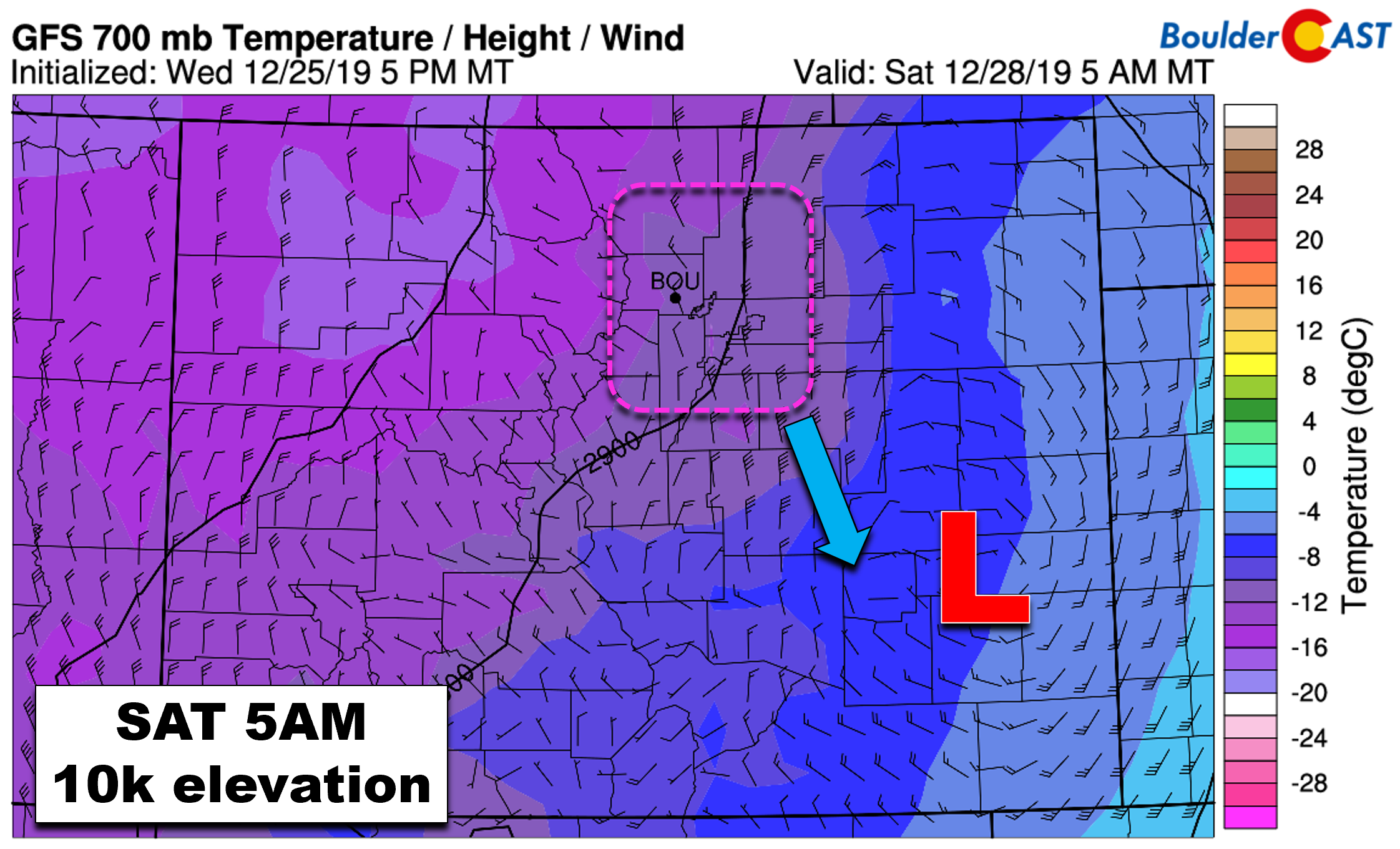
How about at the 700 mb level (approximately 10,000 feet elevation)? Sure, it’s a little colder, but we have no upslope here either. Not good for snow…not good at all!
As you might expect, snow totals resulting from a “mostly downslope” event for us won’t be anywhere near impressive.
Timeline
Highs on Friday will top out in the mid to upper 30’s with patchy morning fog, then partly cloudy skies becoming overcast through the day. There may be a few snow showers around in the afternoon and evening hours, but the bulk of the more widespread snowfall won’t begin until the pre-dawn hours Saturday morning. Given the downslope, snow will be focused east of Interstate 25 across the Metro area where it could be moderate to heavy at times. Winds will intensify with gusts up to 35 mph near and east of DIA Saturday. This could cause some minor travel impacts at the airport and also on roadways due to blizzard-like conditions. Light snow will taper off Saturday afternoon or early evening for most areas, possibly lingering into Saturday night across far northeast Colorado. Temperatures on Saturday (and maybe Sunday as well) won’t make it out of the 20’s!
Snow Amounts
With the track of the low remaining somewhat of a mystery, the weather models have been swirling back and forth on snow amounts these last few days (and still are looking the same way today!). In general, this is what we are seeing in the models right now:
- GFS: 3-5″ Boulder, 5-9″ Denver, more than a foot along I-76 northeast of Denver to Nebraska state-line
- NAM: 1-3″ Boulder, 2-5″ in Denver and northeast
- Euro: 1-3″ Boulder and Denver, 3-7″ well east of Denver
Despite having no upslope at all, the GFS model is the most bullish on snow amounts. This seems massively overdone considering the dismal wind direction indicated by every model. All things considered, our forecast will lean towards the less snowy European and NAM models at this time. We do remind you that confidence in the way this particular snowstorm will play out remains somewhat marginal given the poor model agreement and many moving parts in-play.
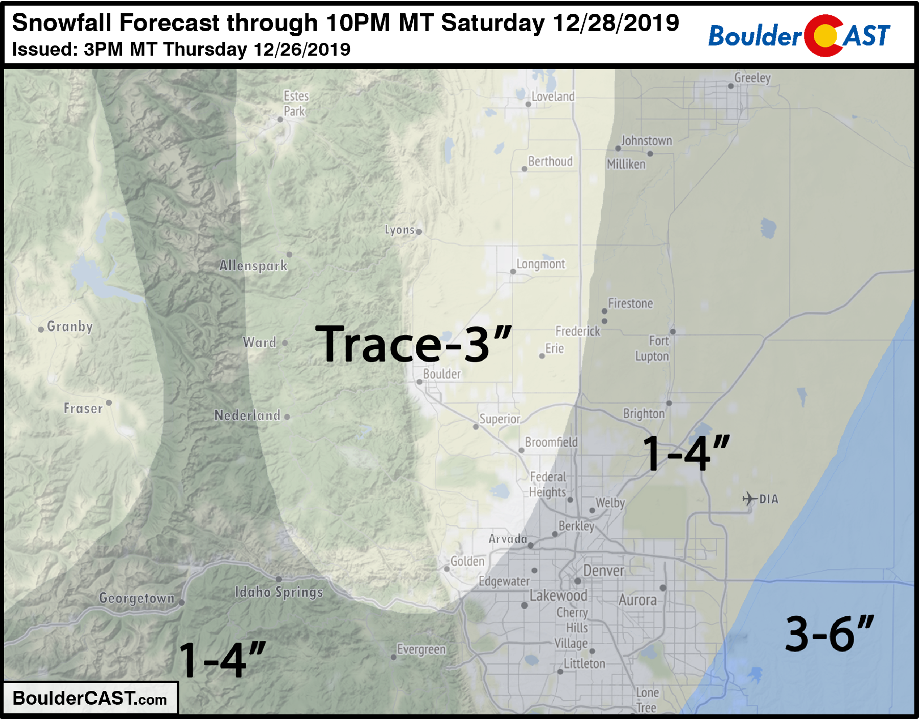
Our snowfall forecast map for the event is shown below. Amounts will be highest east of Denver and lowest from Boulder north to Fort Collins.
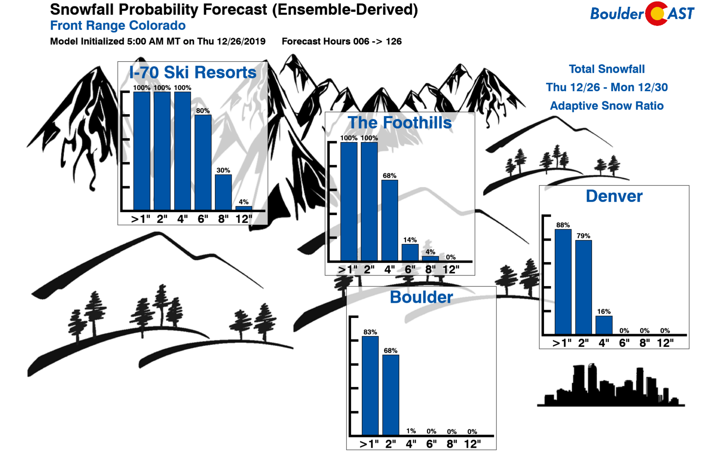
Here are our latest Snowfall Probabilities…a rare situation where they are higher in Denver than in Boulder.
Giving the uncertainty we’re still seeing, there may be some tweaks needed to the forecast before the worst of the snow begins. We’ll pass along any updates to the forecast if needed on Friday. Be sure to stay tuned…
Subscribe to receive email notifications for BoulderCAST updates:
We respect your privacy. You can unsubscribe at any time.
.
LIMITED TIME OFFER: Use the promo code HAPPYHOLIDAYS to save 33% on BoulderCAST Premium.
We discuss Boulder and Denver weather every single day on BoulderCAST Premium. Sign up today to get access to our daily forecast discussions every morning, complete six-day skiing and hiking forecasts powered by machine learning, access to all our Front Range specific weather models, additional storm updates and much more!
.
Spread the word, share the BoulderCAST snow forecast!






You must be logged in to post a comment.