Monday evening’s wet snow brings us closer to normal precipitation for the month of March. We review the snow totals from across the region and discuss our next chance of snow.

GOES-16 water vapor loop for Monday evening and night during the height of the storm.
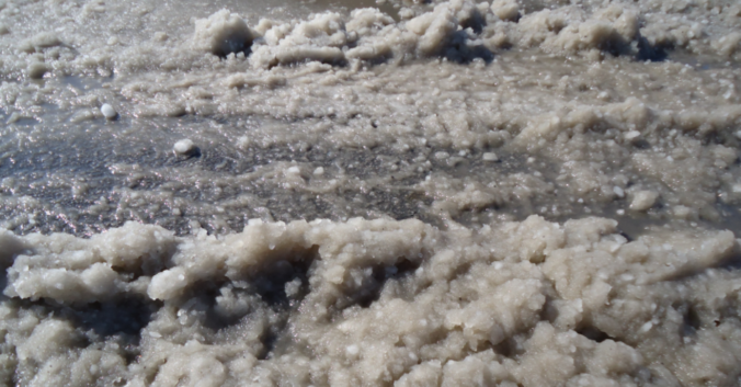
Widespread rain developed during the early evening on Monday across the Metro area, changing to snow for most folks between 6:00 and 9:00 PM. In Boulder, the change-over was around 7:30 PM. You could just tell from the mix bag of precipitation Monday evening how much moisture and warmth the storm was packing. Snowflakes were big and wet, accumulating on the ground in a layer of slush.
Radar and regional temperatures at 11:00PM Monday evening. Snow across all of the Metro area, with rain still falling to the north. (Weather Underground).
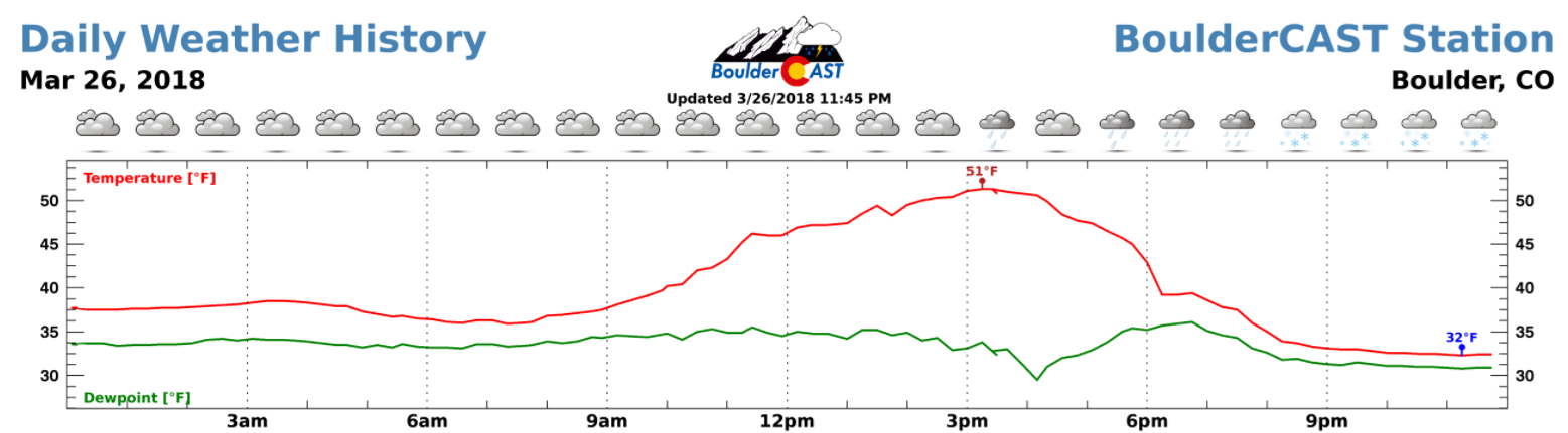
At BoulderCAST Station, we recorded a high temperature of 51 degrees Monday afternoon, dropping into the low 30’s with moderate snow falling during the evening hours and overnight.
Precipitation totals across the Metro area ranged from 0.5″ to 1.0″, with lower amounts to the north towards Longmont. This moisture brings us closer to normal for the month of March, but not quite there. Most areas will still end-up below average when the month closes out this weekend.

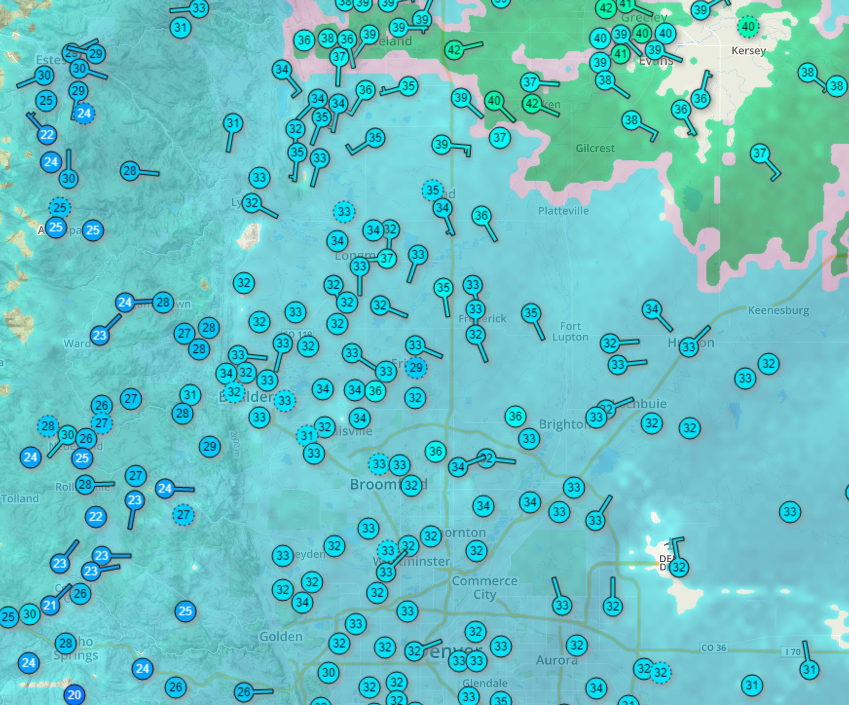
Precipitation totals from across the region for the storm. 0.5 to 1.0″ was common.
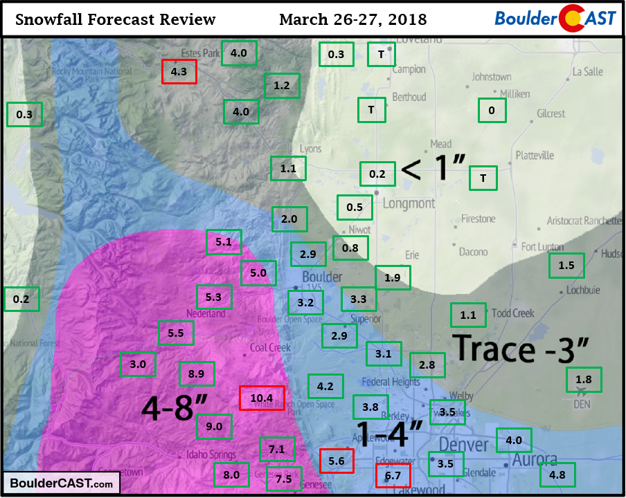
Snow totals were generally inline with our forecast… some 1-4″ across the Plains, with 4-8″ in the Foothills. A few southwestern suburbs of Denver, like Lakewood, hit closer to 6″. The official snowfall total in Boulder was 3.2″ and in Denver, 1.8″. Our respective seasonal totals now stand at 53.2″ in Boulder and 20.8″ in Denver.
Shown below is our original snowfall forecast map (issued Sunday afternoon), with the observed storm totals per location contained in boxes. Green ones indicate that the observed snowfall was within one inch of the given forecast range, while red was outside the scope of our forecast.
The storm largely behaved as expected on all fronts, in terms of total liquid precipitation, rain to snow change-over time, temperatures throughout the evening, and overall snow ratios. This was not an easy forecast by any means. We’re happy with the outcome, and you likely are, too!
NWS check: Their forecast of 2-6″ in the Foothills was generally too low, though they did add the caveat that some spots could see up to 8″ (many locations landed in the 5 to 8″ range). For the lower elevations, their forecast evolved from 0-3″ to 1-4″, with thoughts very similar to our thinking which turned out well.
For the ski resorts, this morning’s reports indicate the storm performed about as expected , with PowderCAST correctly predicting within 2″ for all 22 Colorado ski resorts. Actual totals are shown below in large green/red text to the left of the resort names.

Our next weather system will be riding the northwest flow, and will drop out of Canada into northern Colorado by Wednesday afternoon. This storm will be weaker than the prior storm, and also lacks moisture and upslope. We expect isolated to widely scattered showers during the afternoon and evening, with a focus north of Denver to the Wyoming border. This will be mainly rain for the Plains, with the chance of some snow after sunset as the precipitation wraps-up. At this time, any snow accumulations on the Plains should be a dusting or less and fairly isolated. In the higher Foothills along Peak-to-Peak highway, a couple of inches of snow are possible resulting from convective daytime snow showers and spill-over from the Continental Divide Wednesday evening.
Friday will be the nicest day in the near-term with partly cloudy skies and temperatures in the 60’s. Plan any outdoor activities accordingly. Have a good rest of the week!
Subscribe if you want email updates from us.
Share this winter storm recap:
.


You must be logged in to post a comment.