BoulderCAST
  • Home
  • Home
  • Weather Now
  • Forecasts
    • Hourly Planner
    • Daily Weather
      Discussions
    • Forecast Products
      • Ski Forecast
      • SummitCAST
      • Smoke Forecast
      • SnowTracker
    • Models
      • Model Browsers
        • GFS & NAM
      • Ensembles
        • 15-day Precipitation
        • 10-day Temperature
        • Snowfall Probability Charts
    • Severe Weather
      • 3-Day Severe Outlook
      • Recent Storm Reports
  • Climate Hub
  • Snow
    • Snowfall Probabilities
    • Snowpack
    • Ski Forecast
    • Snow Reports
  • About
    • Meet the Team
    • Help Support Us
    • Consulting Services
    • Merch Store
    • Contact Us
  • Premium
    • Learn More
    • Log in
  • Home
  • Home
  • Weather Now
  • Forecasts
    • Hourly Planner
    • Daily Weather
      Discussions
    • Forecast Products
      • Ski Forecast
      • SummitCAST
      • Smoke Forecast
      • SnowTracker
    • Models
      • Model Browsers
        • GFS & NAM
      • Ensembles
        • 15-day Precipitation
        • 10-day Temperature
        • Snowfall Probability Charts
    • Severe Weather
      • 3-Day Severe Outlook
      • Recent Storm Reports
  • Climate Hub
  • Snow
    • Snowfall Probabilities
    • Snowpack
    • Ski Forecast
    • Snow Reports
  • About
    • Meet the Team
    • Help Support Us
    • Consulting Services
    • Merch Store
    • Contact Us
  • Premium
    • Learn More
    • Log in

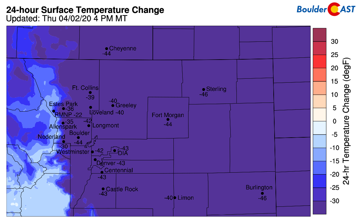
It’s MUCH colder today than it was yesterday!

April 2, 2020 / Ben Castellani

About the author
Ben CastellaniM.S.
BoulderCAST Meteorologist·2,509 posts since 2015
Spent nearly a year living in central Greenland, measuring clouds and snowfall at −80°F.
Ben grew up in southwestern Pennsylvania and holds both a bachelor's and a master's degree in Meteorology, the latter being from CU Boulder. His hometown received nearly three feet of snow from the Storm of the Century back in March of 1993, sparking his initial interest in impactful weather. Ben currently works on remote sensing and data analysis software at NV5 Geospatial Software in Boulder.

  • Winter storms
  • Polar clouds & snowfall
  • Front Range topography
More from Ben Meet the team

Verification, Winter Weather

Previous post
Premium Storm Update – Thu 04/02/20 8:30 AM | Some (freezing) drizzle early, snow arrives this afternoon
Next post
BoulderCAST Daily – Fri 04/03/20 | Foggy but turning sunny
BoulderCAST Premium
Never get caught off guard by Colorado weather.
Go Premium for the forecasts locals plan their days around.
  • Daily Forecast DiscussionOur take on the day's weather every morning, with an optional email to your inbox.
  • All Our Forecast & Climate GraphicsExpanded access to every map, chart and dataset we offer. A must for weather enthusiasts and data nerds alike.
  • Ask Our MeteorologistsRequest a custom forecast for your hike, race, wedding or road trip.
Plus
  • Full 6-day hike & ski forecastsEvery Colorado ski resort and 120+ hiking trails, including every 14er
  • Exclusive content & site featuresBonus high-impact storm updates, weekend outlooks every Thursday and plenty of other extras
  • Wildfire smoke forecastsSmoke concentration predictions up to 84 hours out
  • Chat room accessTalk weather with fellow members and our team
  • No ads anywhereA cleaner, faster BoulderCAST
$3.33/month, billed yearly
or $6.99 month to month · cancel anytime
Get Premium Now
Supports independent, local weather forecasting
Already a member? Log in

Live Radar

Follow Us

Did You Know?

Up until the New Year’s Eve snowstorm on December 31 2021, Boulder and Denver were rocking their all-time lowest cumulative snowfall for any season. This snow came one day too late to prevent the Marshall Fire.

Search BoulderCAST

Trending Content

  • Our 2025-26 Front Range Snow Forecast Report Card: 16 Storms, 30 Towns and a Winter Unlike Any Other
    Our 2025-26 Front Range Snow Forecast Report Card: 16 Storms, 30 Towns and a Winter Unlike Any Other
  • Mid-November Super El Niño Update: Wetter Spring Signals Emerging for Colorado
    Mid-November Super El Niño Update: Wetter Spring Signals Emerging for Colorado
  • BoulderCAST Daily – Wed 11/18/26 | The Mountain Wave Has Arrived (Mostly Up High), Plus the Increasing Chance for Snowflakes This Weekend
    BoulderCAST Daily – Wed 11/18/26 | The Mountain Wave Has Arrived (Mostly Up High), Plus the Increasing Chance for Snowflakes This Weekend
  • Colorado Snowfall Probabilities
    Colorado Snowfall Probabilities

Privacy Policy

© 2026 Front Range Weather, LLC

Up ↑

Loading Comments...

You must be logged in to post a comment.