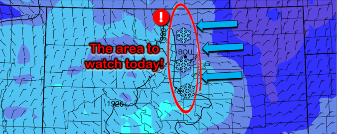
An intriguing weather setup is developing today that will bring a high likelihood of scattered heavy snow showers to the Front Range Wednesday afternoon and evening. The focus will be across the western Denver Metro area, but everyone stands a chance at some snow. We discuss potential snowfall amounts and the impacts to the Wednesday evening commute.
At a Glance:
- A combination of cold air moving in aloft and weak but efficient upslope will produce heavy convective snow showers on Wednesday
- The focus most of the snow will be west of Interstate 25, particularly in and near the Foothills
- Snow amounts of up to 6″ possible, decreasing the further east you are
- Quieter weather the next few days before more snow this weekend
D
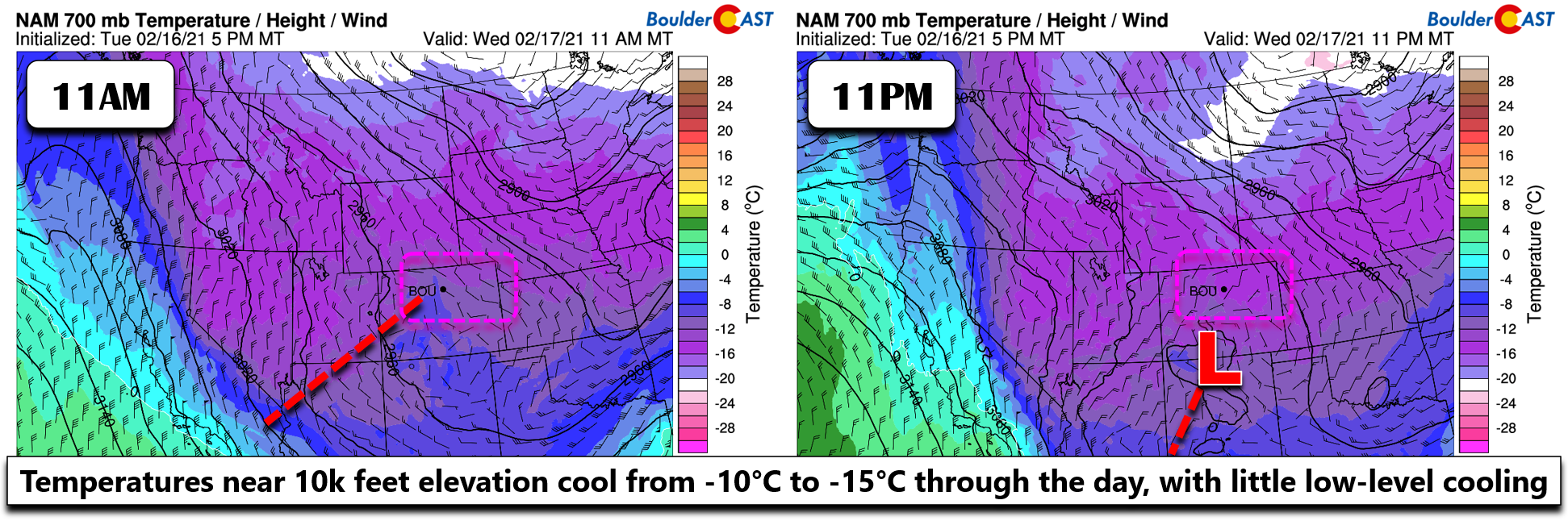
espite the coldest of the Arctic air having exited eastward out of Colorado, an interesting winter weather setup is developing for Wednesday across the Front Range! A weak storm system is progressing through the Four Corners region during the day. While this won’t provide much direct lift to our area, colder air is funneling southward aloft in association to that distant trough. This is shown in the two-panel graphic below. Temperatures at 10,000 feet elevation will cool from -10°C to -15°C through the day. This cooling aloft will help to destabilize and prime the atmosphere. It’s not always intuitive to understand why cold air aloft forces convection, but just think about it. If you put cold air right above, the air below suddenly becomes comparatively warmer and can easily rise up. This is the basic setup today for our area.
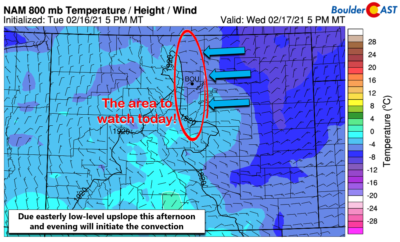
With the atmosphere primed for convection from the cold air, all we need now is a trigger. Today that initiator will be low-level upslope arriving behind a weak frontal push. Models are in agreement for a 10 to 15 MPH due easterly wind flow into the Denver area this afternoon just above the surface, turning more northeasterly by evening. Also, don’t forget that we’re now closer to the Equinox than the Solstice and as such, solar heating is becoming more of a factor in our precipitation events to further enhance convective instability. Given the atmospheric setup, the upslope will be enough to kick-off scattered to numerous snow showers in the Foothills and adjacent Plains through the day.
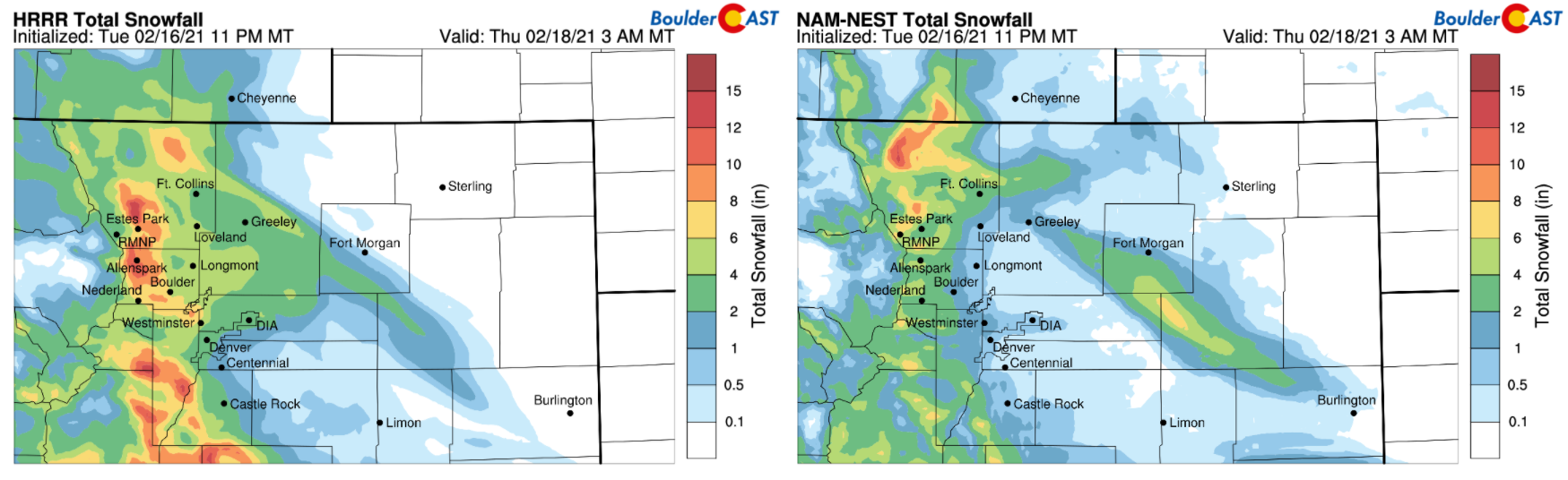
The high-resolution HRRR model precipitation forecast animation below shows the rapid increase in convective activity this afternoon through the evening predominantly west of Interstate 25. This model is probably a little over-zealous on how widespread the snow showers will be, but nonetheless it does confirm the ingredients are coming together.
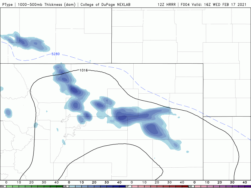
HRRR model simulated precipitation forecast animation for today and tonight
This setup is one that is often poorly probed by the models, which shrouds the situation that will develop later today in a tad of uncertainty. We are quite confident in the location of where the snow showers will form….in the Foothills and in the western Denver Metro area. However, exactly how widespread and intense the snow showers will be remains difficult to predict. This will of course play a large role in how much snow everyone picks up today…so keep that in mind.
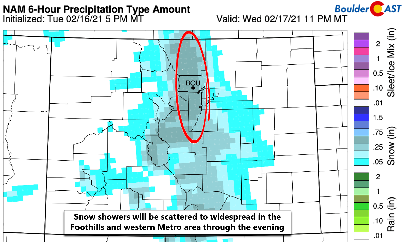
The high-resolution models, those that allow for explicit convection in their algorithms, are showing an agreeable pattern with the highest potential snow amounts in the Foothills and western Metro area.
Global and regional models show this very same pattern as well with a focus on the Foothills. This is not surprising. Notice the sharp gradient with decreasing snowfall amounts heading away from the terrain. This is the result of the snow showers dissipating as they move eastward.
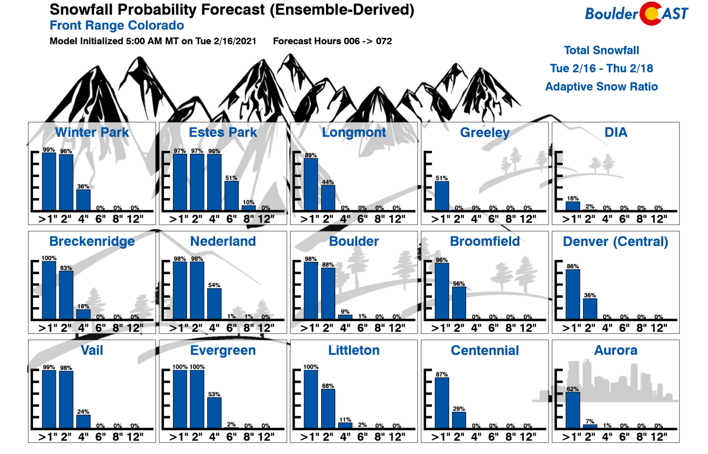
Finally, just as a sanity check, let’s look at some of our Snowfall Probabilities which are derived from ensemble forecast models. Everything looks as it should, with the highest accumulation potential in the Foothills and amounts dropping off quickly heading east away from the terrain. Sorry, DIA…you’re not going to see much snow today!
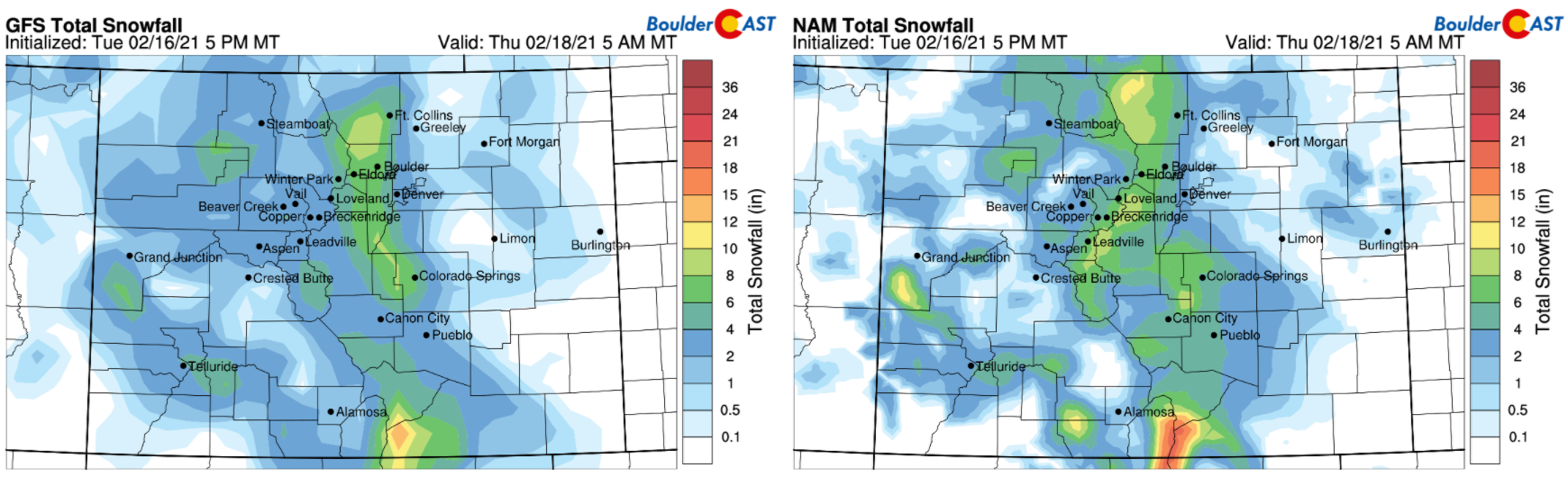
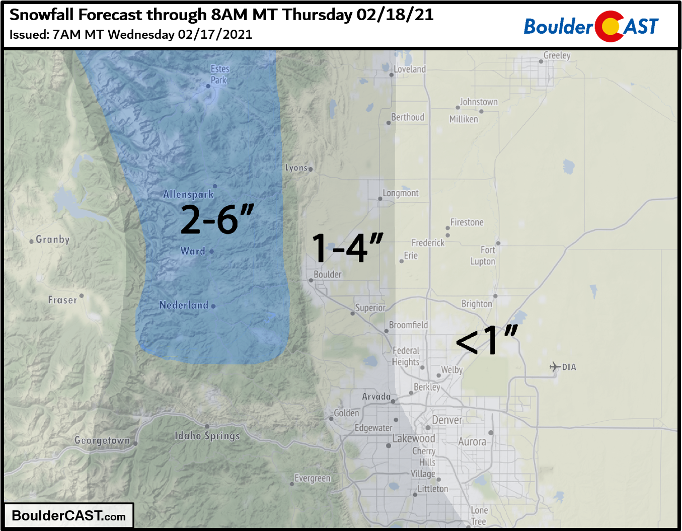
Our snowfall forecast map for this unique convective event is shown below. This covers snow falling through Wednesday night. Again, we stress that amounts may vary somewhat within these ranges. Certainly localized areas could see more or less than their given forecast range. That’s just how these type of events tend to play out. It’s important to note that these snow showers are not jet-forced, so they won’t appear as clear linear features on radar. They should be more discrete, smaller, and circular in appearance so do keep an eye out!
Before the snow, Wednesday will be mostly cloudy with highs in the upper 20’s to near 30 degrees. Convective snow showers will begin to develop around mid-day over the Foothills and Divide, and then slide eastward through the afternoon and evening. Convection will cease by late evening with colder air settling in at the surface as well. Winds will shift to northeasterly and we could see a few hours of lighter more widespread upslope snow before things fully wrap-up after midnight. If you’re traveling in the Foothills or western Denver Metro area this afternoon and evening, be aware of rapidly changing conditions and pockets of heavier snow coating the roadways. The evening commute could be impacted in locations from Longmont, to Boulder, to Golden.
Thursday and Friday will be quieter with a warming trend expected. Our next chance of light snow comes late Saturday and Saturday night. Still too early for specifics on that one. Stay tuned.
Help support BoulderCAST and save 25% with promo code FRIGID
Help support our team of Front Range weather bloggers by joining BoulderCAST Premium. We talk Boulder and Denver weather every single day. Sign up now to get access to our daily forecast discussions each morning, complete six-day skiing and hiking forecasts powered by machine learning, first-class access to all our Colorado-centric high-resolution weather graphics, bonus storm updates and much more! Or not, we just appreciate your readership!

.
Spread the word, share the BoulderCAST forecast:
.


You must be logged in to post a comment.