In typical fashion, September 2020 was a relatively quiet month. Of course, that is with the exception of the unprecedented wild swing in weather that began Labor Day Weekend that ended in our earliest snowfall and earliest freeze on record. Here’s a quick and colorful recap of our weather during September and how it relates to climatology.
Help support our team of Front Range weather bloggers by joining BoulderCAST Premium. We talk Boulder and Denver weather every single day. Sign up now to get access to our daily forecast discussions each morning, complete six-day skiing and hiking forecasts powered by machine learning, first-class access to all our Colorado-centric high-resolution weather graphics, bonus storm updates and much more! Or not, we just appreciate your readership!

Top Weather Highlights of September 2020:
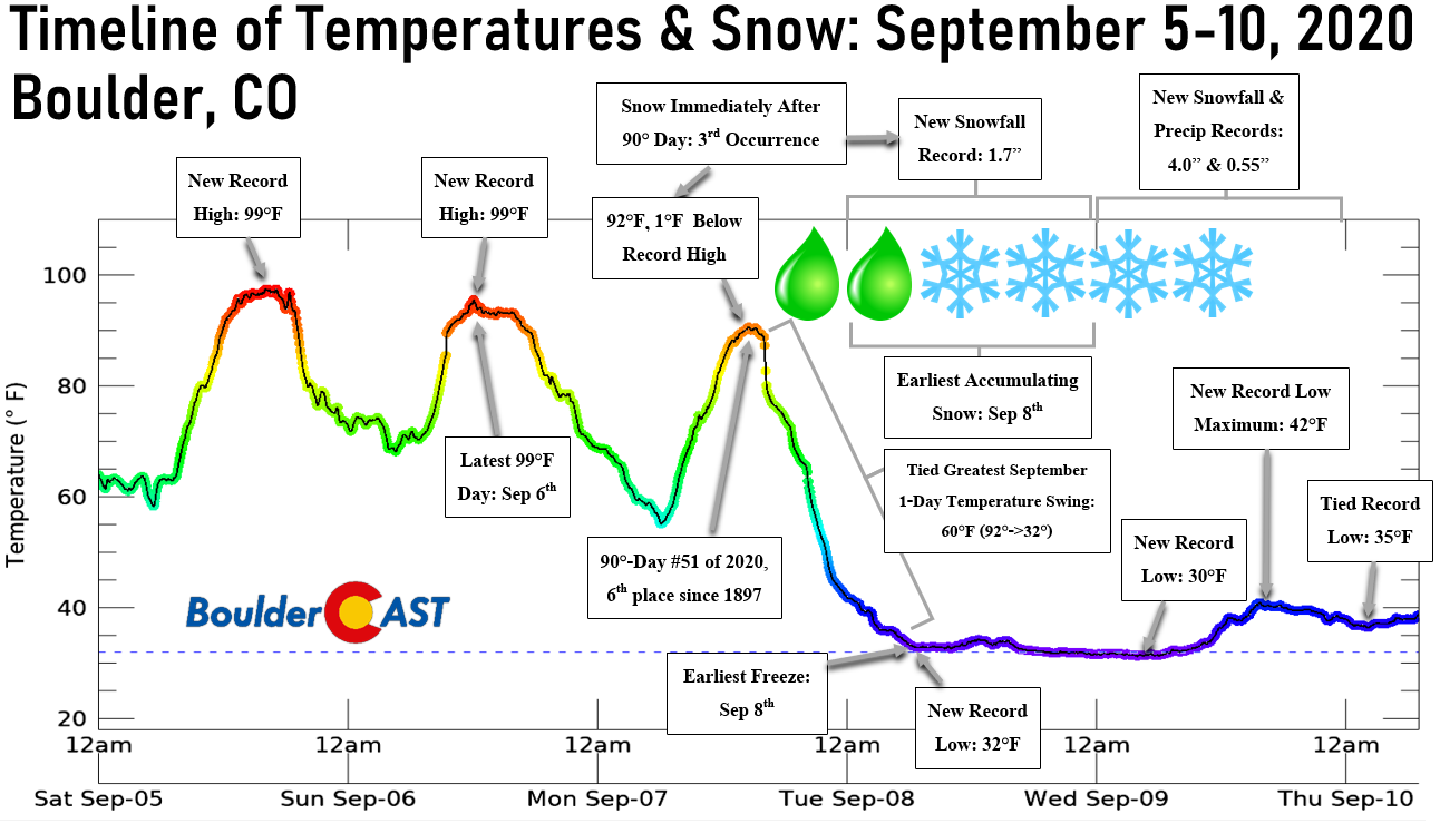
THAT WAS JUST CRAZY! Those are the exact words uttered by many earlier in September to describe the rapid and drastic change in our weather. After three consecutive days of record or near-record heat during the long holiday weekend, the rug got pulled out from under us as a well-forecasted cold front blew through Labor Day night with rain changing to snow and temperatures falling nearly sixty degrees in just 15 hours.
Welcome to Colorado, where the temperature drops 59°F in about ~15 hours and it snows in the summer! #COwx
92°F (4PM Monday) –> 33°F (7AM Tuesday)
More regional graphics: https://t.co/bg05MB0SxZ pic.twitter.com/KAWWtMG2B0
— BoulderCAST Weather (@BoulderCAST) September 8, 2020
Heavy wet snow eventually accumulated on the fully-leafed vegetation across the Denver Metro area leading to downed tree branches and power outages in some locations.
Coming up on 3" in Boulder so far as of 8PM. Lots of melting. New records set for low temperature (32°F) and snowfall amount (1.7") on September 8th #COWx #Boulderwx pic.twitter.com/x0Nghio4yo
— BoulderCAST Weather (@BoulderCAST) September 9, 2020
There was quite the mess to clean-up here in Boulder, which without question got the worst of the storm. The storm total was nearly 6″ in Boulder, with just an inch or so around Denver.
PINPOINT WX: Big cleanup underway in Boulder. Details #KDVR #KWGN pic.twitter.com/BVBIIfZieo
— jimhooley (@jimhooley) September 9, 2020
When it was all said and done, Boulder broke more than dozen records in just five days, with said records incredibly coming from complete opposite ends of the seasonal spectrum. That truly was one of the wildest weeks in Colorado weather we’ve seen in the last decade, and we lived through the 2013 Flood. Don’t forgot to read our recap post for more on this historic weather week if you missed it!
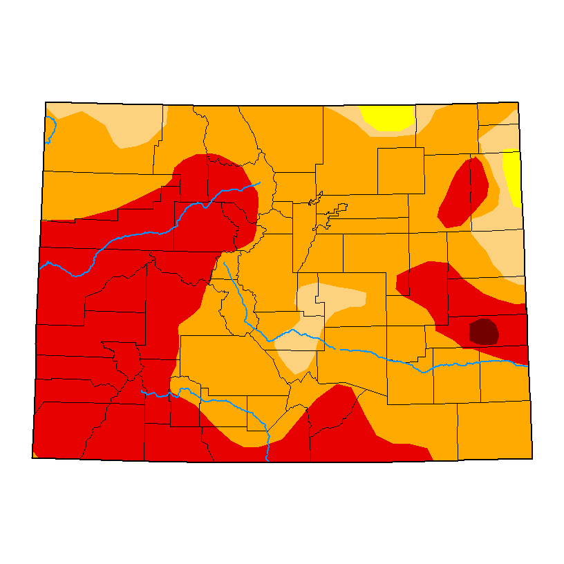
WARM & SMOKY THE REST OF THE MONTH: Beyond that wild week in weather, the remainder of the month was tame across the Front Range. There were only a few isolated rain showers on a couple occasions over the final three weeks. All but one of the last 18 days in the month saw above normal temperatures. Drought only intensified throughout September, as shown in the slider below from the United States Drought Monitor.


Of course these conditions did not help contain the already expansive wildfires across the region. The burn scars from 2020’s wildfires are shown below. The Cameron Peak Fire west of Ft. Collins and the Mullen Fire mostly over the Wyoming border have been the main culprits for spreading smoke into the Denver area the last few weeks.

Current 2020 burn scars in Colorado as of 10/1/20
While the smoke has been intermittent for Boulder and Denver, there have been very few if any “good” air quality days of late and this trend will continue into early October with two of the largest fires in state history raging less than 200 miles away and located unfortunately upstream in the atmosphere.
The drought-stricken and smoke-engulfed prairie of Front Range Colorado 😢 #cowx #smoke #drought #boulderwx pic.twitter.com/4MhndNYOwC
— BoulderCAST Weather (@BoulderCAST) September 20, 2020
September 2020 Recap Graphics:
.


Spread the word, share Colorado weather:
We discuss Boulder and Denver weather every single day on BoulderCAST Premium. Sign up today to get access to our daily forecast discussions every morning, complete six-day skiing and hiking forecasts powered by machine learning, access to all our Front Range specific weather models, additional storm updates and much more!


You must be logged in to post a comment.