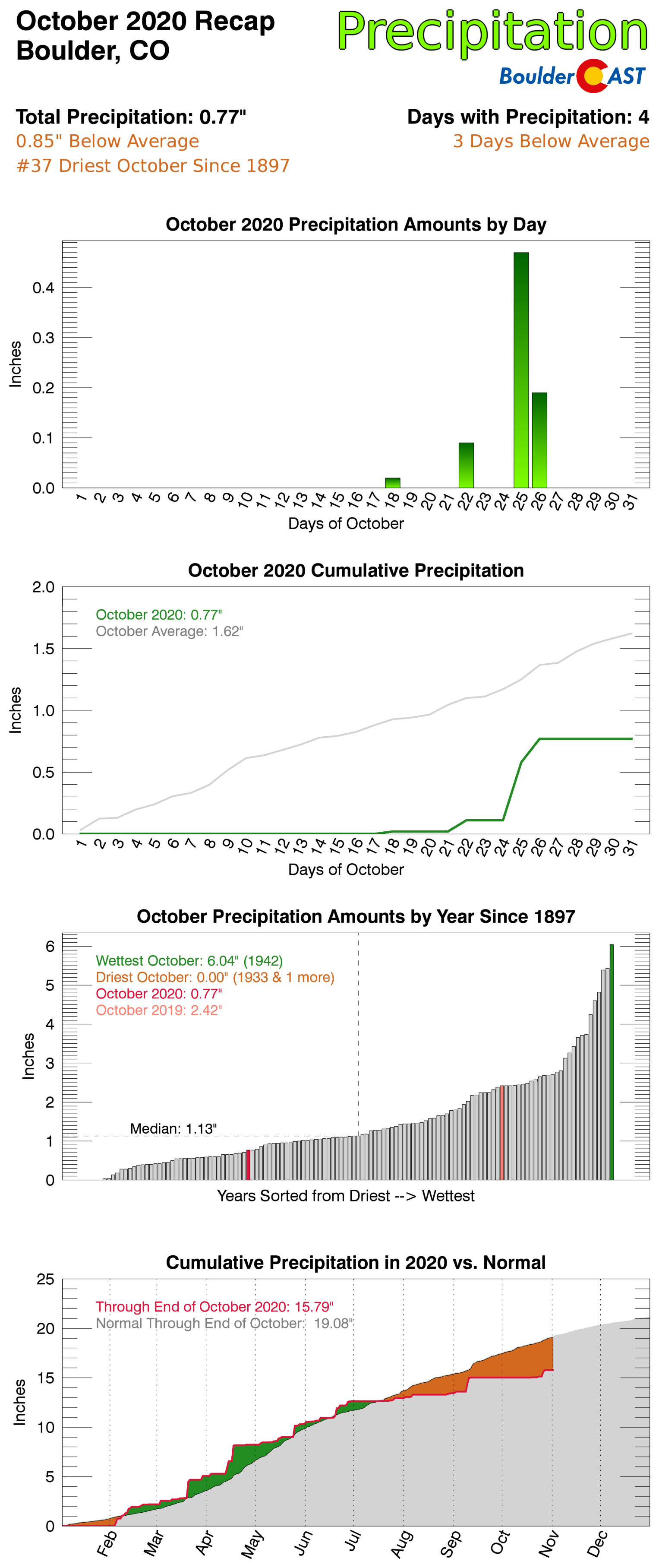
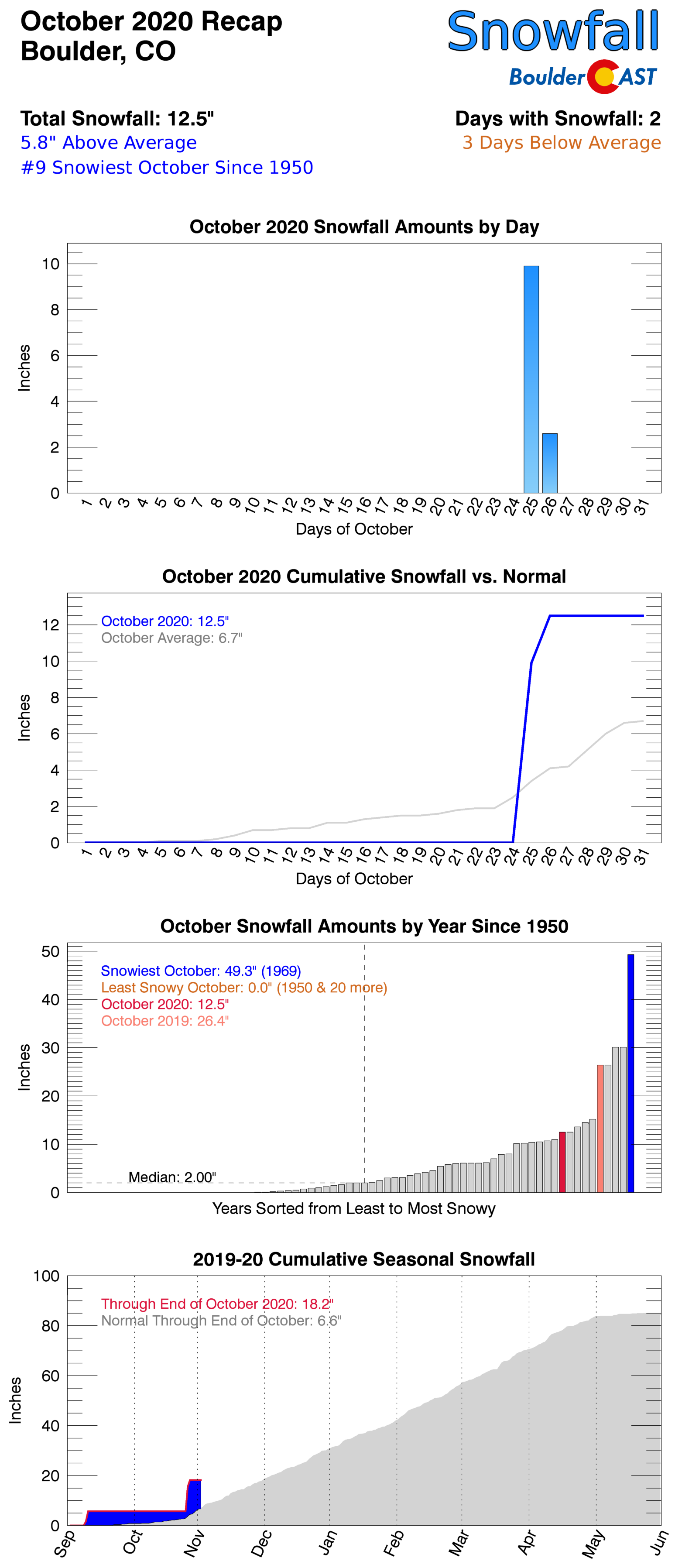
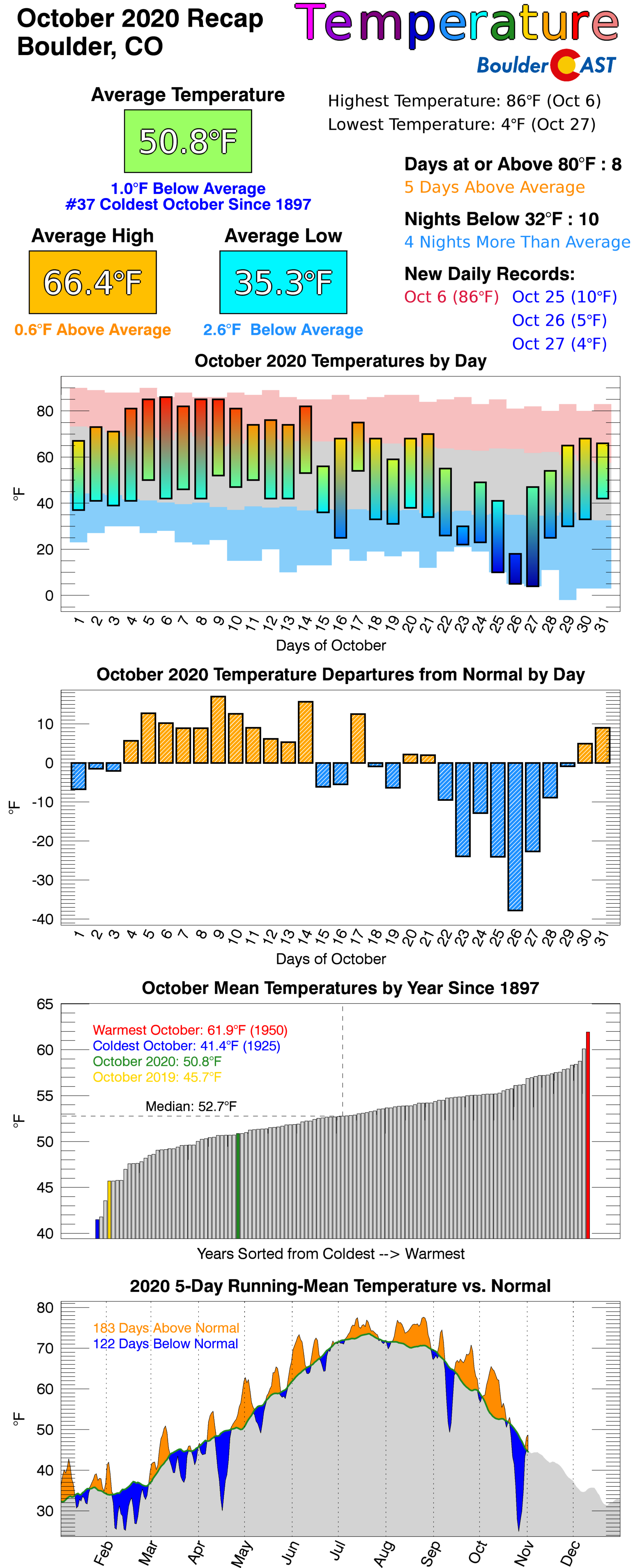
October 2020 checked most of the weather boxes, with record warmth, persistent drought, a dumping of snow, explosive wildfire growth, a dust storm, freezing drizzle, and historic cold. Here’s a quick and colorful rundown of our weather during October and how it relates to climatology.
Help support our team of Front Range weather bloggers by joining BoulderCAST Premium. We talk Boulder and Denver weather every single day. Sign up now to get access to our daily forecast discussions each morning, complete six-day skiing and hiking forecasts powered by machine learning, first-class access to all our Colorado-centric high-resolution weather graphics, bonus storm updates and much more! Or not, we just appreciate your readership!
Top Weather Highlights of October 2020:
80’S TO START OCTOBER! We began the month of October with weather more akin to August, something that has been par for the course since mid-June.
Boulder hit the 80-degree mark on seven consecutive days which was one shy of an October record.
Sunday's cold front arrived just in time to prevent yet another 2020 warmth record in Boulder… #COwx #Boulderwx #ColdFront #OctoberHeat pic.twitter.com/LFTrGg1xSt
— BoulderCAST Weather (@BoulderCAST) October 12, 2020
HEAT TURNS TO SNOW & DUST: The warm stretch came abruptly to an end with a strong Pacific cold front blowing through on October 11th. This front produced blowing dust, smoke, strong downslope winds, high fire danger, and even snow in the Mountains.
That's an organized dust storm out by Wild Horse, Colorado today. #Haboob #9wx 📷: Mark Werts #COwx pic.twitter.com/YLurjwKIxA
— Cory Reppenhagen (@CReppWx) October 11, 2020
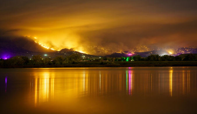
ANOTHER, CLOSER FIRE: On October 17th, during another period of strong downslope winds, the CalWood Fire ignited in western Boulder County.
BOULDER COUNTY — 5min time-lapse of #CalwoodFire burning near Jamestown, CO (as viewed from Niwot.)#FOX31 #cowx pic.twitter.com/Rpd0cDrBk5
— Brooks (@BrooksWeather) October 17, 2020
Later that evening, Mother Nature delivered a cold front quelling the fire below 7000 feet elevation.
A cold front will arrive to the area around 9PM this evening w/ a much needed jolt of moisture and low clouds. The problem is, it's a shallow front and likely will only reach up to ~8000 feet elevation. Hopefully this will help slow the fires down #COwx #CalWoodFire #Boulderwx pic.twitter.com/7CeBCcmDaH
— BoulderCAST Weather (@BoulderCAST) October 18, 2020
The damage had already been done with dozens of structures lost in the Foothills and nearly 9000 acres burned.
This is HWY 36 between Boulder & Lyons last night (left) and this morning (right). The first precipitation we've had in nearly six weeks could not have come at a better time.. Thank you Mother Nature!
More regional webcams: https://t.co/L0VLejKuY3#COwx #CalWoodFire #Boulderwx pic.twitter.com/IoJ2iHWjvk
— BoulderCAST Weather (@BoulderCAST) October 18, 2020
100K ACRES IN ONE DAY? IS THAT EVEN POSSIBLE? The East Troublesome Fire ignited on October 14th, grew somewhat on the 16th, but absolutely exploded on the 21st as strong westerly winds increased in the Mountains. The fire quickly forced the evacuation of Grand Lake, Granby and eventually Estes Peak as the wildfire jumped across the tundra of the Continental Divide and starting coming down into Rocky Mountain National Park towards Estes.
Quite the nocturnal smoke plume coming of the #EastTroublesomeFire right now on radar…It is burning very hot: https://t.co/p2MzBiunVq#COwx pic.twitter.com/U9PlS4ZDk8
— BoulderCAST Weather (@BoulderCAST) October 22, 2020
The fire grew more than 100,000 acres in a single day and became the 2nd largest fire in state history, just behind the still active and growing (at the time) Cameron Peak Fire.
Lots of incredibly scary and sad videos coming from home security cameras of evacuees in Grand County #EastTroublesomeFire https://t.co/sVifnlGFY5
— BoulderCAST Weather (@BoulderCAST) October 22, 2020
FIRST WINTER WEATHER OF OCTOBER: The first wintry weather of the month wasn’t snow, but instead freezing drizzle on October 22nd. Most areas below 7000 feet elevation saw a light coating of freezing drizzle on this day.
Radar tonight is an interesting mix of smoke from the #EastTroublesomeFire aloft & freezining falling east of the Continental Divide. 28°F now. Watch for a few travel slick spots overnight with light snow mixing in at times.
Dont miss our full forecast: https://t.co/KN49kFzt9w pic.twitter.com/vqtk0sUhYg
— BoulderCAST Weather (@BoulderCAST) October 23, 2020
WIDESPREAD SNOW HELPS WITH THE FIRES: Our first snowfall event in nearly eight weeks occurred on October 25-26 and produced up to 18″ of snow in the active burn zones of Cameron Peak, Calwood, and East Troublesome Fires. Snow also fell across the entire Denver Metro area, heaviest from Boulder to Fort Collins where up to a foot was reported.
WINTER STORM RECAP: We take a look back at what was a mostly jet-driven snowfall event across the Front Range, go over the snowfall totals, the potential impact on the fire zones, & look ahead to warmer times: https://t.co/4A3fCP7b7x#COwx #EastTroublesomeFire #CameronPeakFire pic.twitter.com/oGqCEuW4Pd
— BoulderCAST Weather (@BoulderCAST) October 26, 2020
The 12.5″ of snow that fell in Boulder is a rarity during La Niña conditions.
The official storm snowfall total this week in Boulder was 12.5 inches! "Foot of snow" events are comparatively uncommon during La Niña conditions. This event could very well end up being our biggest of the 2020-21 season… #Cowx #LaNina #Boulderwx pic.twitter.com/NIg24b3AeB
— BoulderCAST Weather (@BoulderCAST) October 27, 2020
RECORD OCTOBER COLD: In many ways, the record-shattering cold that accompanied the snow event was just as impressive. Boulder set back-to-back-to-back daily record low temperatures, including the earliest ever single digit temperature and the 2nd coldest ever October temperature reading.
Today was one of the coldest October mornings in Colorado state history. Temperatures sub-zero over a large portion of the Plains, as cold as -33°F in the high Mountain valleys. Boulder's third straight record low at +4°F this AM #COwx
Current conditions: https://t.co/bg05MB0SxZ pic.twitter.com/TrvUQwZvbn
— BoulderCAST Weather (@BoulderCAST) October 27, 2020
#SeaIce extent in the Arctic is at an all-time record low for late October right now (not a joke). Makes sense since all the Arctic air is over Colorado (joke) #cowx
Source NSIDC: https://t.co/FFuhIwpLrS pic.twitter.com/o0PDbUrAyC
— BoulderCAST Weather (@BoulderCAST) October 27, 2020
CONGRATS! We announced the winners of our 6th Annual “Second’ Snowfall Contest following the highly-anticipated wallop of snow. How did you do?
October 2020 Recap Graphics:
.
Featured image of CalWood Fire by Julian (/u/pacard on Reddit)
Spread the word, share Colorado weather:
We discuss Boulder and Denver weather every single day on BoulderCAST Premium. Sign up today to get access to our daily forecast discussions every morning, complete six-day skiing and hiking forecasts powered by machine learning, access to all our Front Range specific weather models, additional storm updates and much more!


You must be logged in to post a comment.